17:
130:
The
Northern Harz Boundary Fault forms the southern border of the Northeast German Basin, a part of the Central European Basin. The Subhercynian Basin, also known as the Harz Foreland, is a small sub-basin of the Northeast German Basin. This intracontinental basin that has been subsided since the
185:
Paleozoic rocks. The Harz was partly thrust over the layers of
Mesozoic rock to the north. Here, the Mesozoic strata were tilted steeply (70-80 degrees) or even overturned. A good example is at the Langenberg Quarry, but there are also many other outcrops that show the steeply sloping strata. In
41:
344:
Zeitliche und genetische
Einordnung von tertiären Sedimentvorkommen im Mittelharz und im Harzvorland: Ein Beitrag zur Reliefentwicklung und zur Karstmorphogenese im Harz
135:
period was formed from the
Hercynian foreland basins and accumulated sediments of the Mesozoic era. The basin was formed by a deformation or bulging of the
273:
252:
177:
Along the western part of the fault, the Harz was lifted by at least 5 to 7 km, which can be estimated from the thickness of the
333:
290:
377:
136:
362:
69:
25:
158:
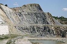
strata. The most intensive phase of uplift occurred in a period of about 2 million years from the middle of the
170:
lie at a much shallower angle than those of the Lower
Cretaceous, and that, in some places, they overlap
73:
190:
are steeply inclined. Near
Blankenburg and Ballenstedt there are rocks lying at steep angles from the
154:. The Harz Block was thrust over the Mesozoic strata of the Subhercynian Basin, steeply tilting its
196:
16:
211:
Springs rise along the entire fault system, both those with low quantities of minerals as well as
367:
224:
112:
80:. The fault is also known in English as the Harz North Rim Fault or Harznordrand Thrust (Fault).
329:
269:
248:
182:
167:
147:
84:
57:
151:
45:
215:
springs. The mineral waters are used, for example, in Bad
Harzburg, by the spa industry.
29:
342:
König W. (2008), Dissertation an der Martin-Luther-Universität Halle-Wittenberg (ed.),
140:
372:
356:
212:
171:
77:
100:
307:
124:
108:
92:
266:
Dynamics of complex intracontinental basins: the
Central European Basin System.
205:
191:
65:
61:
163:
159:
104:
187:
178:
155:
120:
88:
21:
132:
166:. The completion of uplift is shown by the fact that the rocks of the
96:
116:
15:
20:
Steeply inclined strata, overturned towards the south, of the
324:
Mohr K. (1998), M. Gwinner (ed.), "Harz- Westlicher Teil",
328:(in German), vol. 58, Berlin-Stuttgart: Borntraeger,
146:
The
Northern Harz Boundary Fault was activated in the
264:
Littke, Ralf; Bayer, Ulf and
Gajewski, Dirk (2008).
245:
The Geology of Central Europe: Mesozoic and Cenozoic
289:, Society for Geology Applied to Mineral Deposits,
150:and the Harz was uplifted along the line of the
83:The northern edge of the Harz is oriented in a
139:. In the Cretaceous the basin was squeezed by
8:
64:, which consists of rocks formed during the
194:, which form the so-called Devil's Wall or
87:(WNW-ESE) direction and runs from Neuekrug-
181:rocks deposited in the Harz Foreland and
247:, Geological Society, London, p. 1255.
236:
174:. The uplift is still going on today.
7:
143:which also uplifted the Harz Block.
204:, rocks of Heidelberg Sandstone, a
14:
68:Era and folded in the course of
287:SGA Web Mineral Deposit Archive
1:
291:Presentation at www.e-sga.org
326:Sammlung Geologischer Führer
37:Northern Harz Boundary Fault
268:, Springer, Berlin, p. 48.
186:these strata, rocks of the
70:Hercynian mountain building
394:
310:. Accessed on 28 Nov 2010.
346:(in German), p. 151
293:Accessed on 28 Nov 2010.
378:Regions of Lower Saxony
285:Mueller, A;G. (2008).
54:Harznordrandverwerfung
49:
32:
302:Nielsen, Ole (2008).
19:
243:McCann, Tom (2008).
50:Harznordrandstörung
363:Geology of Germany
225:Geology of Germany
208:quartz sandstone.
74:Subhercynian Basin
33:
274:978-3-540-85085-4
253:978-1-86239-264-9
162:age to the lower
72:, borders on the
26:Langenberg quarry
385:
347:
338:
311:
300:
294:
283:
277:
262:
256:
241:
200:. They include,
168:Upper Cretaceous
148:Early Cretaceous
58:geological fault
44:
393:
392:
388:
387:
386:
384:
383:
382:
353:
352:
341:
336:
323:
320:
315:
314:
301:
297:
284:
280:
263:
259:
242:
238:
233:
221:
123:to the area of
40:
12:
11:
5:
391:
389:
381:
380:
375:
370:
365:
355:
354:
349:
348:
339:
334:
319:
316:
313:
312:
304:Salt tectonics
295:
278:
257:
235:
234:
232:
229:
228:
227:
220:
217:
141:Alpine orogeny
13:
10:
9:
6:
4:
3:
2:
390:
379:
376:
374:
371:
369:
366:
364:
361:
360:
358:
351:
345:
340:
337:
335:3-443-15071-3
331:
327:
322:
321:
317:
309:
305:
299:
296:
292:
288:
282:
279:
275:
271:
267:
261:
258:
254:
250:
246:
240:
237:
230:
226:
223:
222:
218:
216:
214:
213:mineral water
209:
207:
203:
199:
198:
193:
189:
184:
180:
175:
173:
169:
165:
161:
157:
153:
149:
144:
142:
138:
134:
128:
126:
122:
118:
114:
110:
106:
102:
98:
94:
90:
86:
81:
79:
78:Harz Foreland
75:
71:
67:
63:
59:
55:
51:
47:
43:
38:
31:
27:
23:
18:
350:
343:
325:
308:my.opera,com
303:
298:
286:
281:
265:
260:
244:
239:
210:
201:
197:Teufelsmauer
195:
176:
172:discordantly
145:
129:
101:Bad Harzburg
82:
53:
36:
34:
30:Göttingerode
125:Ballenstedt
113:Blankenburg
109:Wernigerode
93:Langelsheim
357:Categories
231:References
206:silicified
202:inter alia
192:Cretaceous
66:Palaeozoic
62:Harz Block
60:where the
368:Tectonics
164:Campanian
160:Santonian
105:Ilsenburg
85:Hercynian
42:‹See Tfd›
219:See also
188:Jurassic
179:Mesozoic
156:Mesozoic
121:Gernrode
89:Hahausen
22:Jurassic
318:Sources
133:Permian
56:) is a
24:in the
332:
272:
251:
183:eroded
97:Goslar
46:German
152:fault
117:Thale
28:near
373:Harz
330:ISBN
270:ISBN
249:ISBN
137:Moho
119:and
91:via
35:The
306:at
76:or
52:or
359::
127:.
115:,
111:,
107:,
103:,
99:,
95:,
48::
276:.
255:.
39:(
Text is available under the Creative Commons Attribution-ShareAlike License. Additional terms may apply.