33:
50:
78:
487:
85:
57:
412:
Helton Creek, Chestnut Cove, Spiva Branch, Allison Branch, Wolf Creek, Fortenberry Creek, Morgan Branch, Anderson Creek, Kiutuestia Creek, Brackett Creek, Wash Branch, Youngcane Creek, Jack Creek, Camp Creek, Poteete Creek, Dooley Creek, Butler Creek, Owenby Creek, Rapier Mill Creek, Dickey Branch,
423:
Left Fork, Noah Branch, Polly Branch, Big Branch, Stink Creek, Town Creek, Arkaqua Creek, Atkins Creek, Lawrence Branch, Fields Branch, Laurel Branch, Bony Branch, Butternut Creek, Wellburn Creek, Stephens Branch, Casteel Branch, Ivylog Creek, Chastain Branch, Conley Creek, Thomas Branch, Moccasin
440:
Old Bald
Mountain Road, NC 180, Litton Lane, US 120 (Gainesville Highway), Spiva Bridge Way, Jimmy Nicholson Road, Hutson Road, Lower Owltown Road, Wiles Bridge Road, Blue Ridge Highway, US 76-NC 515, Pat Cowell Road, NC 325, Tate Road, Cook Bridge Road, Raper Road, NC 60, US
1569:
698:
597:
1361:
1441:
1115:
892:
49:
807:
691:
1549:
567:
1130:
1125:
77:
1564:
1554:
1461:
802:
684:
1528:
1263:
1110:
862:
867:
757:
1391:
1268:
1100:
797:
1456:
1431:
1288:
933:
918:
500:
1559:
259:
589:
142:
32:
1055:
1426:
1293:
530:
1487:
1492:
184:
1343:
1223:
1193:
737:
490:
The
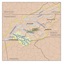
Hiwassee drainage basin, which includes the Nottely River, located within the upper Tennessee drainage basin
1213:
1120:
1105:
671:
559:
1248:
1218:
1198:
1183:
998:
812:
1466:
1338:
1333:
1278:
1228:
1085:
968:
948:
897:
817:
1518:
1386:
1381:
1023:
928:
747:
137:
1401:
1313:
1203:
1178:
708:
460:
456:
127:
1513:
1298:
1283:
1145:
1075:
1013:
752:
1436:
1396:
1160:
1050:
882:
1366:
1258:
1070:
827:
376:
1523:
1446:
1135:
877:
622:
1421:
1371:
1303:
1238:
1208:
1028:
923:
772:
767:
762:
655:
651:
368:
364:
235:
1497:
1416:
1406:
1376:
1318:
1243:
1150:
1060:
953:
913:
887:
872:
857:
842:
832:
792:
732:
468:
388:
380:
334:
123:
1543:
1482:
1411:
1155:
1080:
1065:
1045:
1008:
1003:
963:
852:
847:
742:
722:
480:
464:
452:
113:
647:
U.S. Geological Survey. National
Hydrography Dataset high-resolution flowline data.
1451:
1328:
1308:
1273:
1233:
1095:
978:
958:
938:
837:
782:
727:
676:
476:
1188:
1170:
1140:
1090:
1018:
988:
983:
973:
943:
787:
777:
472:
230:
486:
1323:
1253:
993:
372:
274:
261:
199:
186:
672:
U.S. Geological Survey
Geographic Names Information System: Nottely River
648:
347:
699.33 cu ft/s (19.803 m/s) at mouth with
Hiawassee River
463:. The river flows for 51.1 miles (82.2 km) into the artificial
485:
680:
424:
Creek, Cobb Creek, Rominger Creek, Cane Creek, Sneed Branch
560:"Nottely River Topo Map, Cherokee County NC (Murphy Area)"
1506:
1475:
1352:
1169:
1037:
906:
715:
436:
428:
417:
406:
398:
386:
360:
355:
341:
328:
320:
308:
300:
290:
251:
241:
229:
215:
176:
166:
158:
149:
133:
119:
109:
104:
21:
1570:Bodies of water of Cherokee County, North Carolina
172:about 1.5 miles northeast of Double Top Mountain
692:
8:
554:
552:
503:, it has also been known historically as:
617:
615:
699:
685:
677:
517:
525:
523:
521:
162:confluence of Right Fork and Left Fork
18:
84:
56:
7:
570:from the original on 17 October 2019
501:Geographic Names Information System
312:287.93 square miles (745.7 km)
14:
1550:Tributaries of the Hiwassee River
1362:Alligator (Little Ocmulgee River)
600:from the original on 1 April 2019
92:Nottely River (the United States)
1442:Sweetwater (Chattahoochee River)
1111:Little Ogeechee (Hancock County)
623:"Nottely River Watershed Report"
413:Walker Mill Creek, Laurel Branch
83:
76:
55:
48:
37:The river in Cherokee County, NC
31:
1565:Rivers of Union County, Georgia
1269:Little Satilla (Atlantic Ocean)
1264:Little Ogechee (Chatham County)
64:Location of Nottely River mouth
1555:Rivers of Georgia (U.S. state)
1116:Little Satilla (Satilla River)
455:. The river originates in the
253: • coordinates
178: • coordinates
1:
531:"GNIS Detail - Nottely River"
304:49.12 mi (79.05 km)
150:Physical characteristics
95:Show map of the United States
16:Stream in North Carolina, USA
808:Little (Withlacoochee River)
432:Nottely Lake, Hiawassee Lake
292: • elevation
217: • elevation
330: • location
243: • location
168: • location
25:Tributary to Hiwassee River
1586:
1289:North River (Darien River)
343: • average
296:1,525 ft (465 m)
221:2,398 ft (731 m)
67:Show map of North Carolina
1131:New (Withlacoochee River)
1126:New (Chattahoochee River)
763:Chattooga (Tugaloo River)
707:Significant waterways of
658:, accessed April 27, 2011
351:
316:
225:
154:
42:
30:
1560:Rivers of North Carolina
1488:Brunswick–Altamaha Canal
1056:Black (Okefenokee Swamp)
590:"ArcGIS Web Application"
471:. The Nottely River is
419: • right
1493:Savannah–Ogeechee Canal
1462:Walnut (Ocmulgee River)
1294:North (St. Marys River)
803:Little (Savannah River)
758:Chattooga (Coosa River)
408: • left
1529:List of Georgia rivers
863:South (Ocmulgee River)
537:. US Geological Survey
491:
1519:Intracoastal Waterway
1101:Little (Etowah River)
798:Little (Oconee River)
489:
475:in Georgia, creating
275:35.08972°N 84.07639°W
200:34.74972°N 83.84639°W
1457:Walnut (South River)
1432:Spring (Flint River)
457:Blue Ridge Mountains
594:epa.maps.arcgis.com
356:Basin features
280:35.08972; -84.07639
271: /
205:34.74972; -83.84639
196: /
1106:Little Ochlockonee
999:Richard B. Russell
654:2012-03-29 at the
492:
465:Hiwassee Reservoir
451:is a river in the
1537:
1536:
949:George W. Andrews
813:Little Tallapoosa
566:. Locality, LLC.
535:geonames.usgs.gov
499:According to the
445:
444:
377:Mississippi River
1577:
1524:Okefenokee Swamp
1467:Williamson Swamp
1024:Walter F. George
818:Little Tennessee
701:
694:
687:
678:
659:
649:The National Map
645:
639:
638:
636:
634:
627:Waters Geoviewer
619:
610:
609:
607:
605:
586:
580:
579:
577:
575:
556:
547:
546:
544:
542:
527:
483:is a tributary.
420:
409:
391:
344:
337:(Hiawassee Lake)
331:
286:
285:
283:
282:
281:
276:
272:
269:
268:
267:
264:
218:
211:
210:
208:
207:
206:
201:
197:
194:
193:
192:
189:
179:
169:
96:
87:
86:
80:
68:
59:
58:
52:
35:
19:
1585:
1584:
1580:
1579:
1578:
1576:
1575:
1574:
1540:
1539:
1538:
1533:
1502:
1471:
1387:Ichawaynochaway
1354:
1348:
1165:
1039:
1033:
902:
711:
705:
668:
663:
662:
656:Wayback Machine
646:
642:
632:
630:
621:
620:
613:
603:
601:
588:
587:
583:
573:
571:
558:
557:
550:
540:
538:
529:
528:
519:
514:
497:
418:
407:
394:Hiawassee River
387:
369:Tennessee River
365:Hiawassee River
342:
329:
293:
279:
277:
273:
270:
265:
262:
260:
258:
257:
254:
244:
236:Hiawassee River
216:
204:
202:
198:
195:
190:
187:
185:
183:
182:
177:
167:
141:
126:
100:
99:
98:
97:
94:
93:
90:
89:
88:
71:
70:
69:
66:
65:
62:
61:
60:
38:
26:
23:
17:
12:
11:
5:
1583:
1581:
1573:
1572:
1567:
1562:
1557:
1552:
1542:
1541:
1535:
1534:
1532:
1531:
1526:
1521:
1516:
1510:
1508:
1504:
1503:
1501:
1500:
1498:Suwannee Canal
1495:
1490:
1485:
1479:
1477:
1473:
1472:
1470:
1469:
1464:
1459:
1454:
1449:
1444:
1439:
1434:
1429:
1424:
1419:
1414:
1409:
1404:
1402:Little Satilla
1399:
1394:
1389:
1384:
1379:
1374:
1369:
1364:
1358:
1356:
1350:
1349:
1347:
1346:
1341:
1336:
1331:
1326:
1321:
1316:
1311:
1306:
1301:
1296:
1291:
1286:
1281:
1276:
1271:
1266:
1261:
1256:
1251:
1246:
1241:
1236:
1231:
1226:
1221:
1216:
1211:
1206:
1201:
1196:
1191:
1186:
1181:
1175:
1173:
1167:
1166:
1164:
1163:
1158:
1153:
1148:
1143:
1138:
1133:
1128:
1123:
1121:Mulberry River
1118:
1113:
1108:
1103:
1098:
1093:
1088:
1083:
1078:
1073:
1068:
1063:
1058:
1053:
1048:
1042:
1040:
1038:Smaller rivers
1035:
1034:
1032:
1031:
1026:
1021:
1016:
1014:Strom Thurmond
1011:
1006:
1001:
996:
991:
986:
981:
976:
971:
966:
961:
956:
951:
946:
941:
936:
931:
926:
921:
916:
910:
908:
904:
903:
901:
900:
895:
890:
885:
880:
875:
870:
865:
860:
855:
850:
845:
843:Ogeechee River
840:
835:
830:
825:
820:
815:
810:
805:
800:
795:
790:
785:
780:
775:
770:
765:
760:
755:
750:
745:
740:
735:
730:
725:
719:
717:
713:
712:
706:
704:
703:
696:
689:
681:
675:
674:
667:
666:External links
664:
661:
660:
640:
611:
581:
548:
516:
515:
513:
510:
509:
508:
496:
493:
469:North Carolina
443:
442:
438:
434:
433:
430:
426:
425:
421:
415:
414:
410:
404:
403:
400:
396:
395:
392:
384:
383:
381:Gulf of Mexico
362:
358:
357:
353:
352:
349:
348:
345:
339:
338:
335:Hiwassee River
332:
326:
325:
322:
318:
317:
314:
313:
310:
306:
305:
302:
298:
297:
294:
291:
288:
287:
255:
252:
249:
248:
247:Hiawassee Lake
245:
242:
239:
238:
233:
227:
226:
223:
222:
219:
213:
212:
180:
174:
173:
170:
164:
163:
160:
156:
155:
152:
151:
147:
146:
135:
131:
130:
124:North Carolina
121:
117:
116:
111:
107:
106:
102:
101:
91:
82:
81:
75:
74:
73:
72:
63:
54:
53:
47:
46:
45:
44:
43:
40:
39:
36:
28:
27:
24:
15:
13:
10:
9:
6:
4:
3:
2:
1582:
1571:
1568:
1566:
1563:
1561:
1558:
1556:
1553:
1551:
1548:
1547:
1545:
1530:
1527:
1525:
1522:
1520:
1517:
1515:
1512:
1511:
1509:
1505:
1499:
1496:
1494:
1491:
1489:
1486:
1484:
1483:Augusta Canal
1481:
1480:
1478:
1474:
1468:
1465:
1463:
1460:
1458:
1455:
1453:
1450:
1448:
1445:
1443:
1440:
1438:
1435:
1433:
1430:
1428:
1427:Rocky Comfort
1425:
1423:
1420:
1418:
1415:
1413:
1410:
1408:
1405:
1403:
1400:
1398:
1395:
1393:
1390:
1388:
1385:
1383:
1380:
1378:
1375:
1373:
1370:
1368:
1365:
1363:
1360:
1359:
1357:
1351:
1345:
1342:
1340:
1337:
1335:
1332:
1330:
1327:
1325:
1322:
1320:
1317:
1315:
1312:
1310:
1307:
1305:
1302:
1300:
1299:North Newport
1297:
1295:
1292:
1290:
1287:
1285:
1282:
1280:
1277:
1275:
1272:
1270:
1267:
1265:
1262:
1260:
1257:
1255:
1252:
1250:
1247:
1245:
1242:
1240:
1237:
1235:
1232:
1230:
1227:
1225:
1222:
1220:
1217:
1215:
1212:
1210:
1207:
1205:
1202:
1200:
1197:
1195:
1192:
1190:
1187:
1185:
1182:
1180:
1177:
1176:
1174:
1172:
1168:
1162:
1159:
1157:
1154:
1152:
1149:
1147:
1146:South Newport
1144:
1142:
1139:
1137:
1134:
1132:
1129:
1127:
1124:
1122:
1119:
1117:
1114:
1112:
1109:
1107:
1104:
1102:
1099:
1097:
1094:
1092:
1089:
1087:
1084:
1082:
1079:
1077:
1074:
1072:
1069:
1067:
1064:
1062:
1059:
1057:
1054:
1052:
1049:
1047:
1044:
1043:
1041:
1036:
1030:
1027:
1025:
1022:
1020:
1017:
1015:
1012:
1010:
1007:
1005:
1002:
1000:
997:
995:
992:
990:
987:
985:
982:
980:
977:
975:
972:
970:
967:
965:
962:
960:
957:
955:
952:
950:
947:
945:
942:
940:
937:
935:
932:
930:
927:
925:
922:
920:
917:
915:
912:
911:
909:
905:
899:
896:
894:
893:Withlacoochee
891:
889:
886:
884:
881:
879:
876:
874:
871:
869:
866:
864:
861:
859:
856:
854:
851:
849:
846:
844:
841:
839:
836:
834:
831:
829:
826:
824:
821:
819:
816:
814:
811:
809:
806:
804:
801:
799:
796:
794:
791:
789:
786:
784:
781:
779:
776:
774:
771:
769:
766:
764:
761:
759:
756:
754:
753:Chattahoochee
751:
749:
746:
744:
741:
739:
736:
734:
731:
729:
726:
724:
721:
720:
718:
716:Larger rivers
714:
710:
702:
697:
695:
690:
688:
683:
682:
679:
673:
670:
669:
665:
657:
653:
650:
644:
641:
628:
624:
618:
616:
612:
599:
595:
591:
585:
582:
569:
565:
561:
555:
553:
549:
536:
532:
526:
524:
522:
518:
511:
506:
505:
504:
502:
495:Variant names
494:
488:
484:
482:
481:Arkaqua Creek
478:
474:
470:
466:
462:
458:
454:
453:United States
450:
449:Nottely River
439:
435:
431:
427:
422:
416:
411:
405:
401:
397:
393:
390:
385:
382:
378:
374:
370:
366:
363:
359:
354:
350:
346:
340:
336:
333:
327:
323:
319:
315:
311:
307:
303:
299:
295:
289:
284:
256:
250:
246:
240:
237:
234:
232:
228:
224:
220:
214:
209:
181:
175:
171:
165:
161:
157:
153:
148:
144:
139:
136:
132:
129:
125:
122:
118:
115:
114:United States
112:
108:
103:
79:
51:
41:
34:
29:
22:Nottely River
20:
1437:Suwannoochee
1397:Kinchafoonee
1171:Tidal rivers
1161:Willacoochee
1051:Alapahoochee
883:Toccoa/Ocoee
822:
643:
631:. Retrieved
626:
602:. Retrieved
593:
584:
572:. Retrieved
563:
539:. Retrieved
534:
507:Notley River
498:
477:Lake Nottely
459:in northern
448:
446:
389:River system
1367:Big Satilla
1259:Laurel View
1071:Coosawattee
828:Ochlockonee
429:Waterbodies
399:Tributaries
361:Progression
278: /
266:084°04′35″W
203: /
191:083°50′47″W
1544:Categories
1447:Tobesofkee
1353:Creeks and
1344:Wilmington
1224:Cumberland
1136:Oostanaula
1029:West Point
924:Blackshear
919:Banks Lake
878:Tallapoosa
633:17 October
604:17 October
596:. US EPA.
574:17 October
541:17 October
512:References
373:Ohio River
309:Basin size
263:35°05′23″N
188:34°44′59″N
1514:Grand Bay
1422:Peachtree
1372:Brasstown
1304:Odingsell
1239:Frederica
1209:Chestatee
1194:Brunswick
954:Goat Rock
914:Allatoona
868:St. Marys
773:Conasauga
768:Canoochee
738:Apalachee
321:Discharge
1507:See also
1417:Okapilco
1407:Muckalee
1377:Ebenezer
1319:Skidaway
1244:Halfmoon
1214:Crescent
1151:Tallulah
1061:Cartecay
1009:Sinclair
1004:Seminole
964:Hartwell
888:Towaliga
873:Suwannee
858:Savannah
833:Ocmulgee
793:Hiwassee
733:Altamaha
652:Archived
629:. US EPA
598:Archived
568:Archived
564:TopoZone
143:Cherokee
105:Location
1412:Noonday
1355:streams
1249:Hampton
1219:Crooked
1199:Buffalo
1184:Belfast
1156:Tugaloo
1081:Ellijay
1066:Coleman
1046:Alabaha
979:Nottely
969:Jackson
959:Harding
939:Chatuge
934:Carters
853:Satilla
848:Ohoopee
823:Nottely
743:Aucilla
723:Alapaha
709:Georgia
461:Georgia
437:Bridges
128:Georgia
110:Country
1476:Canals
1452:Toccoa
1392:Kettle
1382:Euchee
1339:Vernon
1334:Turtle
1329:Tivoli
1309:Sapelo
1279:Medway
1274:Mackay
1234:Duplin
1229:Darien
1096:Jerico
1086:Hudson
1019:Tugalo
989:Oliver
984:Oconee
974:Lanier
944:Chehaw
929:Burton
898:Yellow
838:Oconee
783:Etowah
728:Alcovy
473:dammed
402:
324:
301:Length
159:Source
134:County
1189:Broro
1141:Soque
1091:Jacks
994:Rabun
907:Lakes
788:Flint
778:Coosa
748:Broad
231:Mouth
138:Union
120:State
1324:Sope
1314:Shad
1254:Herb
1204:Bull
1179:Bear
635:2019
606:2019
576:2019
543:2019
447:The
145:(NC)
140:(GA)
1284:Mud
1076:Dog
467:in
1546::
625:.
614:^
592:.
562:.
551:^
533:.
520:^
479:.
441:64
379:→
375:→
371:→
367:→
700:e
693:t
686:v
637:.
608:.
578:.
545:.
Text is available under the Creative Commons Attribution-ShareAlike License. Additional terms may apply.