90:
26:
223:
208:
95:
1252:
456:
118:
69:
442:
240:
44:
1313:
540:
1289:
1308:
296:. For the first while in the town it is known as Pugwash Road. It then turns to the west and is known as Water Street. Most of Water Street is also
549:
475:
463:
183:
499:
331:
533:
1282:
561:
191:
1318:
1166:
526:
262:
164:
1275:
1226:
300:. Near the centre of Oxford the route turns southward and is known as Main Street where it has an interchange with
341:
309:
1201:
336:
634:
629:
624:
619:
614:
609:
604:
599:
594:
584:
579:
574:
569:
415:
362:
325:
301:
266:
98:
76:
367:
285:
274:
125:
1181:
1150:
1145:
1140:
1135:
1130:
1125:
1120:
1115:
1110:
1105:
1100:
1095:
1090:
1085:
1080:
1075:
1070:
1065:
1060:
1055:
1050:
1045:
1040:
1035:
1030:
1025:
1020:
1015:
1010:
1005:
1000:
995:
985:
980:
975:
970:
965:
960:
955:
950:
945:
940:
935:
930:
925:
920:
915:
910:
905:
900:
895:
890:
885:
880:
875:
870:
865:
860:
855:
850:
845:
840:
835:
830:
825:
820:
815:
810:
805:
800:
795:
790:
785:
780:
775:
770:
765:
760:
755:
750:
406:
402:
395:
297:
226:
211:
102:
715:
710:
705:
700:
695:
690:
685:
419:
357:
305:
1211:
1196:
680:
675:
670:
665:
660:
655:
650:
449:
429:
352:
346:
313:
293:
278:
270:
121:
106:
72:
1191:
495:
1259:
510:
1216:
1186:
726:
1206:
733:
25:
1302:
1231:
1221:
1176:
588:
518:
289:
448:
The section of
Collector Highway 321 from Springhill to Oxford was designated as
1251:
1171:
720:
553:
255:
154:
455:
441:
462:
The section of
Highway 321 from Oxford to Port Phillip was designated as
239:
1258:
This Nova Scotia road, road transport or highway-related article is a
378:
Major
Intersections/Junctions in order from Port Howe to Springhill.
251:
144:
45:
Nova Scotia
Department of Transportation and Infrastructure Renewal
522:
454:
440:
349:(known as Water Street, Main Street and Upper Main Street)
1263:
288:
it travels southward following the eastern banks of
1159:
743:
643:
560:
316:in Springhill and is known locally as Main Street.
174:
160:
150:
140:
135:
112:
82:
63:
58:
50:
37:
21:
1283:
534:
8:
1290:
1276:
541:
527:
519:
200:
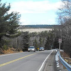
243:Route 321 outside Springhill, Nova Scotia
238:
1314:Roads in Cumberland County, Nova Scotia
487:
476:List of Nova Scotia provincial highways
308:). From there it travels southward to
18:
312:where it turns westward and heads to
7:
1248:
1246:
1182:Digby Neck and Islands Scenic Drive
1262:. You can help Knowledge (XXG) by
184:Provincial highways in Nova Scotia
14:
401:Upper/Lower Main Street, Oxford (
1250:
494:Atlantic Canada Back Road Atlas
221:
206:
116:
93:
88:
67:
24:
1309:Nova Scotia provincial highways
16:Highway in Nova Scotia, Canada
1:
1167:Bras d'Or Lakes Scenic Drive
54:38 km (24 mi)
428:Junction Road, Springhill (
250:is a collector road in the
1335:
1245:
199:
179:
170:
131:
42:
1202:Fundy Shore Scenic Drive
412:Black River Road, Oxford
394:Birchwood Road, Oxford (
1212:Kejimkujik Scenic Drive
1319:Nova Scotia road stubs
459:
445:
328:(known as Main Street)
244:
458:
444:
242:
420:Trans Canada Highway
391:Water Street, Oxford
385:Hansford Siding Road
306:Trans Canada Highway
1197:Fundy Shore Ecotour
374:Major intersections
84:Major intersections
1192:Fleur-de-lis Trail
550:Roads and highways
511:Map of Nova Scotia
460:
452:before the 1960s.
446:
245:
1271:
1270:
1240:
1239:
500:978-1-55368-618-7
263:Cumberland County
261:It is located in
237:
236:
233:
232:
38:Route information
1326:
1292:
1285:
1278:
1254:
1247:
1217:Lighthouse Route
1187:Evangeline Trail
543:
536:
529:
520:
503:
492:
464:Trunk Highway 21
229:
225:
224:
214:
210:
209:
201:
120:
119:
97:
96:
92:
91:
85:
71:
70:
28:
19:
1334:
1333:
1329:
1328:
1327:
1325:
1324:
1323:
1299:
1298:
1297:
1296:
1243:
1241:
1236:
1155:
744:Collector roads
739:
727:Dunbrack Street
639:
556:
547:
516:
507:
506:
493:
489:
484:
472:
450:Trunk Highway 4
439:
376:
322:
292:to the town of
222:
220:
207:
205:
117:
94:
89:
83:
68:
59:Major junctions
33:
32:
29:
17:
12:
11:
5:
1332:
1330:
1322:
1321:
1316:
1311:
1301:
1300:
1295:
1294:
1287:
1280:
1272:
1269:
1268:
1255:
1238:
1237:
1235:
1234:
1229:
1224:
1219:
1214:
1209:
1207:Glooscap Trail
1204:
1199:
1194:
1189:
1184:
1179:
1174:
1169:
1163:
1161:
1157:
1156:
1154:
1153:
1148:
1143:
1138:
1133:
1128:
1123:
1118:
1113:
1108:
1103:
1098:
1093:
1088:
1083:
1078:
1073:
1068:
1063:
1058:
1053:
1048:
1043:
1038:
1033:
1028:
1023:
1018:
1013:
1008:
1003:
998:
993:
988:
983:
978:
973:
968:
963:
958:
953:
948:
943:
938:
933:
928:
923:
918:
913:
908:
903:
898:
893:
888:
883:
878:
873:
868:
863:
858:
853:
848:
843:
838:
833:
828:
823:
818:
813:
808:
803:
798:
793:
788:
783:
778:
773:
768:
763:
758:
753:
747:
745:
741:
740:
738:
737:
734:Bedford Bypass
730:
723:
718:
713:
708:
703:
698:
693:
688:
683:
678:
673:
668:
663:
658:
653:
647:
645:
641:
640:
638:
637:
632:
627:
622:
617:
612:
607:
602:
597:
592:
582:
577:
572:
566:
564:
558:
557:
548:
546:
545:
538:
531:
523:
514:
513:
505:
504:
486:
485:
483:
480:
479:
478:
471:
468:
438:
435:
434:
433:
426:
423:
413:
410:
399:
392:
389:
386:
383:
375:
372:
371:
370:
365:
360:
355:
350:
344:
339:
334:
329:
321:
318:
235:
234:
231:
230:
217:
215:
197:
196:
195:
194:
188:
187:
177:
176:
175:Highway system
172:
171:
168:
167:
162:
158:
157:
152:
148:
147:
142:
138:
137:
133:
132:
129:
128:
114:
113:North end
110:
109:
86:
80:
79:
65:
64:South end
61:
60:
56:
55:
52:
48:
47:
43:Maintained by
40:
39:
35:
34:
30:
23:
22:
15:
13:
10:
9:
6:
4:
3:
2:
1331:
1320:
1317:
1315:
1312:
1310:
1307:
1306:
1304:
1293:
1288:
1286:
1281:
1279:
1274:
1273:
1267:
1265:
1261:
1256:
1253:
1249:
1244:
1233:
1232:Sunrise Trail
1230:
1228:
1225:
1223:
1222:Marconi Trail
1220:
1218:
1215:
1213:
1210:
1208:
1205:
1203:
1200:
1198:
1195:
1193:
1190:
1188:
1185:
1183:
1180:
1178:
1177:Ceilidh Trail
1175:
1173:
1170:
1168:
1165:
1164:
1162:
1160:Scenic routes
1158:
1152:
1149:
1147:
1144:
1142:
1139:
1137:
1134:
1132:
1129:
1127:
1124:
1122:
1119:
1117:
1114:
1112:
1109:
1107:
1104:
1102:
1099:
1097:
1094:
1092:
1089:
1087:
1084:
1082:
1079:
1077:
1074:
1072:
1069:
1067:
1064:
1062:
1059:
1057:
1054:
1052:
1049:
1047:
1044:
1042:
1039:
1037:
1034:
1032:
1029:
1027:
1024:
1022:
1019:
1017:
1014:
1012:
1009:
1007:
1004:
1002:
999:
997:
994:
992:
989:
987:
984:
982:
979:
977:
974:
972:
969:
967:
964:
962:
959:
957:
954:
952:
949:
947:
944:
942:
939:
937:
934:
932:
929:
927:
924:
922:
919:
917:
914:
912:
909:
907:
904:
902:
899:
897:
894:
892:
889:
887:
884:
882:
879:
877:
874:
872:
869:
867:
864:
862:
859:
857:
854:
852:
849:
847:
844:
842:
839:
837:
834:
832:
829:
827:
824:
822:
819:
817:
814:
812:
809:
807:
804:
802:
799:
797:
794:
792:
789:
787:
784:
782:
779:
777:
774:
772:
769:
767:
764:
762:
759:
757:
754:
752:
749:
748:
746:
742:
735:
731:
728:
724:
722:
719:
717:
714:
712:
709:
707:
704:
702:
699:
697:
694:
692:
689:
687:
684:
682:
679:
677:
674:
672:
669:
667:
664:
662:
659:
657:
654:
652:
649:
648:
646:
642:
636:
633:
631:
628:
626:
623:
621:
618:
616:
613:
611:
608:
606:
603:
601:
598:
596:
593:
590:
589:Cobequid Pass
586:
583:
581:
578:
576:
573:
571:
568:
567:
565:
563:
559:
555:
551:
544:
539:
537:
532:
530:
525:
524:
521:
517:
512:
509:
508:
501:
497:
491:
488:
481:
477:
474:
473:
469:
467:
465:
457:
453:
451:
443:
436:
431:
427:
424:
421:
417:
414:
411:
408:
404:
400:
397:
393:
390:
388:Hansford Road
387:
384:
381:
380:
379:
373:
369:
366:
364:
361:
359:
356:
354:
351:
348:
345:
343:
340:
338:
335:
333:
330:
327:
324:
323:
319:
317:
315:
311:
307:
303:
299:
295:
291:
287:
282:
280:
276:
272:
268:
265:and connects
264:
259:
257:
253:
249:
241:
228:
218:
216:
213:
203:
202:
198:
193:
190:
189:
186:
185:
181:
180:
178:
173:
169:
166:
163:
159:
156:
153:
149:
146:
143:
139:
134:
130:
127:
123:
115:
111:
108:
104:
100:
99:Hwy 104 (TCH)
87:
81:
78:
74:
66:
62:
57:
53:
49:
46:
41:
36:
27:
20:
1264:expanding it
1257:
1242:
1227:Marine Drive
990:
644:Trunk routes
515:
490:
461:
447:
377:
342:River Philip
332:Salt Springs
310:River Philip
290:River Philip
283:
260:
254:province of
247:
246:
182:
1172:Cabot Trail
554:Nova Scotia
425:Wyvern Road
416:Highway 104
382:Murray Road
337:Valley Road
320:Communities
302:Highway 104
256:Nova Scotia
155:Nova Scotia
1303:Categories
562:100-series
482:References
326:Springhill
267:Springhill
192:100-series
165:Cumberland
77:Springhill
407:Route 204
403:Route 301
396:Route 204
368:Port Howe
363:Riverview
298:Route 204
286:Port Howe
275:Port Howe
248:Route 321
227:Route 322
212:Route 320
126:Port Howe
103:Route 204
31:Route 321
470:See also
418:Exit 6 (
252:Canadian
161:Counties
151:Province
136:Location
101: /
502:Page 51
437:History
430:Route 2
358:Rockley
314:Trunk 2
279:Trunk 6
271:Route 2
141:Country
122:Trunk 6
73:Trunk 2
498:
405:, and
353:Kolbec
347:Oxford
294:Oxford
145:Canada
107:Oxford
51:Length
284:From
273:with
1260:stub
732:33 (
725:32 (
496:ISBN
1151:395
1146:376
1141:374
1136:368
1131:366
1126:362
1121:360
1116:359
1111:358
1106:357
1101:354
1096:349
1091:348
1086:347
1081:344
1076:341
1071:340
1066:337
1061:336
1056:335
1051:334
1046:333
1041:332
1036:331
1031:330
1026:329
1021:328
1016:327
1011:326
1006:325
1001:324
996:322
991:321
986:320
981:318
976:316
971:312
966:311
961:309
956:308
951:307
946:306
941:305
936:304
931:303
926:302
921:301
916:289
911:277
906:276
901:256
896:255
891:253
886:252
881:247
876:246
871:245
866:242
861:239
856:236
851:224
846:223
841:221
836:219
831:217
826:216
821:215
816:214
811:213
806:212
801:211
796:210
791:209
786:208
781:207
776:206
771:205
766:204
761:203
756:202
751:201
635:162
630:142
625:125
620:118
615:113
610:111
605:107
600:106
595:105
585:104
580:103
575:102
570:101
552:in
277:at
269:at
124:in
105:in
75:in
1305::
721:30
716:28
711:22
706:19
701:16
696:14
691:12
686:10
466:.
422:).
281:.
258:.
219:→
204:←
1291:e
1284:t
1277:v
1266:.
736:)
729:)
681:8
676:7
671:6
666:4
661:3
656:2
651:1
591:)
587:(
542:e
535:t
528:v
432:)
409:)
398:)
304:(
Text is available under the Creative Commons Attribution-ShareAlike License. Additional terms may apply.