334:
362:
348:
311:. Water from the Delta–Mendota Canal is lifted a vertical distance of 8 feet (2.4 m) into a channel running 2,200 feet (670 m) into the forebay. The peak inflow to the forebay is 15,600 cubic feet (440 m) per second, from both the San Luis Dam and the Delta–Mendota Canal. Drainage area of the reservoir downstream of the San Luis Dam is only 18 acres (7.3 ha).
40:
292:
of the reservoir. At 87.5 feet (26.7 m) high, with a maximum reservoir depth of 57 feet (17 m), the crest of the dam is 14,300 feet (4,400 m) long, at an elevation of 223 feet (68 m). The spillway is, as mentioned before, a morning-glory (inverted bell) design, capacity 3,250
319:
The O'Neill
Pumping-Generating Plant produces 28 megawatts (38,000 hp). Irregular water releases from the San Luis Dam and William R. Gianelli Powerplant are collected in the reservoir of the O'Neill Dam, which has a capacity of 56,400 acre-feet (69,600 dam).
511:
1934:
846:
504:
1959:
1939:
497:
1653:
1450:
1949:
832:
284:
Built from 1963 to 1967, the dam is an earthfill and rockfill construction stretching over 3 miles (4.8 km) across the valley of San Luis Creek. A
377:
1841:
475:
1717:
1094:
1079:
77:
1008:
855:
1810:
466:
1311:
960:
839:
1443:
1316:
1815:
1227:
1954:
1924:
1377:
1217:
1084:
1003:
988:
908:
471:
1459:
1296:
1276:
1189:
1099:
767:
1281:
813:
1436:
1367:
1362:
1184:
1119:
1109:
1089:
1929:
1851:
1800:
1722:
1613:
1515:
1407:
1261:
792:
245:
1321:
1306:
1271:
1253:
1212:
1028:
993:
965:
1525:
1775:
1588:
1475:
1331:
1286:
1049:
1033:
556:
261:
61:
1944:
1836:
1790:
1417:
1023:
918:
886:
148:
1785:
1638:
1565:
716:
308:
1530:
461:
1820:
1795:
1732:
1570:
1560:
1412:
1402:
1397:
1018:
934:
684:
576:
367:
257:
1505:
1291:
1074:
983:
520:
1805:
1643:
1673:
1603:
1013:
913:
741:
696:
249:
1510:
1372:
1341:
1266:
1169:
1134:
881:
659:
17:
1555:
736:
401:
1780:
1770:
1744:
1678:
1207:
998:
950:
746:
711:
706:
1754:
1749:
1683:
1663:
1608:
1520:
1485:
1326:
721:
701:
654:
269:
1648:
649:
435:
302:
265:
200:
1593:
1495:
1144:
1139:
787:
726:
339:
1846:
1712:
1346:
1124:
797:
782:
772:
674:
644:
596:
307:
The O'Neill
Forebay reservoir is fed by releases from the San Luis Dam as well as from the
1668:
1301:
1149:
611:
561:
293:
cubic feet (92 m) per second, and with a circumference of 641.5 feet (195.5 m).
489:
1876:
US Bureau of
Reclamation / Projects & Facilities / Powerplants / O`Neill Powerplant
1623:
762:
634:
601:
215:
1918:
1702:
1628:
1500:
1164:
581:
253:
65:
1598:
1540:
1480:
1232:
1154:
1129:
731:
669:
591:
541:
353:
273:
1895:
1871:
1428:
1633:
1550:
1490:
1179:
1114:
955:
664:
639:
629:
606:
361:
824:
1707:
1658:
1618:
1545:
1336:
1174:
1159:
1104:
859:
777:
586:
566:
551:
546:
536:
329:
289:
233:
92:
79:
1580:
621:
347:
234:
U.S. Geological Survey
Geographic Names Information System: O'Neill Dam
39:
1900:
US Bureau of
Reclamation / Projects & Facilities / Dams / O`Neill Dam
899:
872:
285:
1736:
1693:
688:
1432:
828:
493:
1467:
528:
272:, it is roughly 2.5 miles (4.0 km) downstream from the
1935:
Buildings and structures in Merced County, California
1829:
1763:
1731:
1692:
1579:
1466:
1390:
1355:
1252:
1245:
1198:
1067:
1058:
1042:
974:
943:
927:
895:
866:
806:
755:
683:
620:
527:
224:
214:
206:
196:
191:
183:
175:
167:
159:
154:
144:
126:
108:
71:
57:
49:
32:
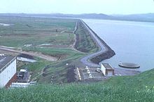
44:O'Neill Forebay and Dam as seen from left bank.
1444:
840:
505:
8:
314:
1451:
1437:
1429:
1249:
1064:
847:
833:
825:
512:
498:
490:
436:"Station Meta Data: O'Neill Forebay (ONF)"
38:
29:
378:List of dams and reservoirs in California
1960:Hydroelectric power plants in California
1940:United States Bureau of Reclamation dams
1842:California Department of Water Resources
476:United States Department of the Interior
1863:
389:
434:Department of Water Resources (2009).
395:
393:
521:Central Valley Project Infrastructure
296:
210:56,400 acre⋅ft (69,600 dam)
18:O'Neill Pumping-Generating Plant
7:
1950:Dams in the San Joaquin River basin
467:Geographic Names Information System
1718:Sacramento–San Joaquin River Delta
1312:Imperial Solar Energy Center South
1085:Big Creek No. 1, 2, 2A, 3, 4 and 8
1009:Los Esteros Critical Energy Center
25:
1317:Imperial Solar Energy Center West
408:. U.S. Department of the Interior
1811:O'Neill Pumping-Generating Plant
406:Projects and Facilities Database
360:
346:
332:
315:O'Neill Pumping-Generating Plant
248:, 12 miles (19 km) west of
1378:Solar Energy Generating Systems
1302:Desert Stateline Solar Facility
1004:Huntington Beach Energy Project
989:Donald Von Raesfeld Power Plant
472:United States Geological Survey
440:California Data Exchange Center
256:, on the eastern slopes of the
220:18 sq mi (47 km)
1460:California State Water Project
1297:Centinela Solar Energy Project
1277:California Flats Solar Project
400:Bureau of Reclamation (2009).
1:
1282:California Valley Solar Ranch
814:C.W. Bill Jones Pumping Plant
179:14,300 ft (4,400 m)
1368:Ivanpah Solar Power Facility
1363:Genesis Solar Energy Project
914:Puente Hills Energy Recovery
1852:Bay Delta Conservation Plan
1816:Oroville–Thermalito Complex
1801:Feather River Fish Hatchery
1408:San Gorgonio Pass Wind Farm
1262:Antelope Valley Solar Ranch
286:morning-glory type spillway
132:; 57 years ago
114:; 61 years ago
1976:
1322:McCoy Solar Energy Project
1307:Desert Sunlight Solar Farm
1272:Blythe Solar Power Project
1029:Russell City Energy Center
994:Gateway Generating Station
300:
171:87.5 ft (26.7 m)
1776:Buena Vista Pumping Plant
1332:Panoche Valley Solar Farm
1287:Campo Verde Solar Project
297:O'Neill Forebay reservoir
232:
228:2,250 acres (910 ha)
62:Merced County, California
37:
1837:CALFED Bay-Delta Program
1791:Dos Amigos Pumping Plant
1786:Devil Canyon Power Plant
1639:Little Panoche Reservoir
1418:Tehachapi Pass Wind Farm
1024:Moss Landing Power Plant
935:Argus Cogeneration Plant
149:US Bureau of Reclamation
1821:South Bay Pumping Plant
1796:Edmonston Pumping Plant
1413:Shiloh Wind Power Plant
1403:Altamont Pass Wind Farm
1398:Alta Wind Energy Center
1125:Mammoth Pool Powerhouse
577:Red Bluff Diversion Dam
368:Renewable energy portal
244:is an earthfill dam on
187:124 ft (38 m)
109:Construction began
27:Dam in California, U.S.
1955:Central Valley Project
1925:Dams completed in 1967
1292:Catalina Solar Project
1170:San Francisquito No. 1
984:Alamitos Energy Center
919:Sunshine Gas Producers
1604:Clifton Court Forebay
1185:White Rock Powerhouse
1014:Metcalf Energy Center
742:Stockton Ship Channel
442:. State of California
250:Los Banos, California
1872:"O'Neill Powerplant"
1566:Thermalito Diversion
1373:Mojave Solar Project
1342:Springbok Solar Farm
1267:Beacon Solar Project
1135:New Bullards Bar Dam
1120:Loon Lake Powerhouse
660:Sugar Pine Reservoir
258:Pacific Coast Ranges
93:37.0805°N 121.0472°W
1806:Kern River Intertie
1781:Castaic Power Plant
1771:Banks Pumping Plant
1745:California Aqueduct
1696:and bodies of water
1679:Thermalito Afterbay
1644:Los Banos Reservoir
1561:Thermalito Afterbay
1233:William R. Gianelli
1130:Moccasin Powerhouse
1095:Caribou No. 1 and 2
999:Glenarm Power Plant
747:Tehama-Colusa Canal
717:Delta–Mendota Canal
712:Delta Cross Channel
309:Delta–Mendota Canal
268:, a forebay to the
216:Catchment area
207:Total capacity
89: /
1930:Dams in California
1755:South Bay Aqueduct
1750:North Bay Aqueduct
1684:Thermalito Forebay
1674:Tehachapi Afterbay
1664:San Luis Reservoir
1609:Elderberry Forebay
1571:Thermalito Forebay
1506:Elderberry Forebay
1327:Mount Signal Solar
1110:Jaybird Powerhouse
722:Folsom South Canal
702:Contra Costa Canal
697:Clear Creek Tunnel
655:San Luis Reservoir
270:San Luis Reservoir
98:37.0805; -121.0472
1860:
1859:
1594:Bethany Reservoir
1426:
1425:
1386:
1385:
1241:
1240:
1145:New Exchequer Dam
1140:New Don Pedro Dam
1090:Camino Powerhouse
1080:Belden Powerhouse
822:
821:
788:San Joaquin River
727:Friant-Kern Canal
462:"O'Neill Forebay"
340:California portal
239:
238:
225:Surface area
184:Width (base)
155:Dam and spillways
127:Opening date
16:(Redirected from
1967:
1910:
1909:
1907:
1906:
1892:
1886:
1885:
1883:
1882:
1868:
1847:Peripheral Canal
1764:Other facilities
1713:Sacramento River
1453:
1446:
1439:
1430:
1347:Topaz Solar Farm
1250:
1190:William E. Warne
1075:Balch Powerhouse
1065:
849:
842:
835:
826:
807:Other facilities
798:Stanislaus River
783:Sacramento River
773:Chowchilla River
675:Whiskeytown Lake
645:New Melones Lake
597:Spring Creek Dam
514:
507:
500:
491:
486:
484:
483:
450:
448:
447:
417:
416:
414:
413:
397:
370:
365:
364:
356:
351:
350:
342:
337:
336:
335:
140:
138:
133:
122:
120:
115:
104:
103:
101:
100:
99:
94:
90:
87:
86:
85:
82:
42:
30:
21:
1975:
1974:
1970:
1969:
1968:
1966:
1965:
1964:
1945:Embankment dams
1915:
1914:
1913:
1904:
1902:
1894:
1893:
1889:
1880:
1878:
1870:
1869:
1865:
1861:
1856:
1825:
1759:
1727:
1688:
1669:Silverwood Lake
1649:O'Neill Forebay
1575:
1462:
1457:
1427:
1422:
1382:
1351:
1237:
1200:
1194:
1150:New Melones Dam
1060:
1054:
1038:
976:
970:
961:Imperial Valley
939:
923:
897:
891:
887:Elkhorn Battery
870:
868:
862:
853:
823:
818:
802:
751:
679:
650:O'Neill Forebay
616:
612:Whiskeytown Dam
562:New Melones Dam
523:
518:
481:
479:
460:
457:
445:
443:
433:
430:
421:
420:
411:
409:
399:
398:
391:
386:
374:
373:
366:
359:
352:
345:
338:
333:
331:
326:
317:
305:
303:O'Neill Forebay
299:
282:
266:O'Neill Forebay
201:O'Neill Forebay
136:
134:
131:
118:
116:
113:
97:
95:
91:
88:
83:
80:
78:
76:
75:
45:
33:O'Neill Dam
28:
23:
22:
15:
12:
11:
5:
1973:
1971:
1963:
1962:
1957:
1952:
1947:
1942:
1937:
1932:
1927:
1917:
1916:
1912:
1911:
1887:
1862:
1858:
1857:
1855:
1854:
1849:
1844:
1839:
1833:
1831:
1827:
1826:
1824:
1823:
1818:
1813:
1808:
1803:
1798:
1793:
1788:
1783:
1778:
1773:
1767:
1765:
1761:
1760:
1758:
1757:
1752:
1747:
1741:
1739:
1729:
1728:
1726:
1725:
1723:San Luis Creek
1720:
1715:
1710:
1705:
1699:
1697:
1690:
1689:
1687:
1686:
1681:
1676:
1671:
1666:
1661:
1656:
1651:
1646:
1641:
1636:
1631:
1626:
1624:Lake Del Valle
1621:
1616:
1614:Frenchman Lake
1611:
1606:
1601:
1596:
1591:
1585:
1583:
1577:
1576:
1574:
1573:
1568:
1563:
1558:
1553:
1548:
1543:
1538:
1533:
1528:
1526:Little Panoche
1523:
1521:Grizzly Valley
1518:
1513:
1508:
1503:
1498:
1493:
1488:
1483:
1478:
1472:
1470:
1464:
1463:
1458:
1456:
1455:
1448:
1441:
1433:
1424:
1423:
1421:
1420:
1415:
1410:
1405:
1400:
1394:
1392:
1388:
1387:
1384:
1383:
1381:
1380:
1375:
1370:
1365:
1359:
1357:
1353:
1352:
1350:
1349:
1344:
1339:
1334:
1329:
1324:
1319:
1314:
1309:
1304:
1299:
1294:
1289:
1284:
1279:
1274:
1269:
1264:
1258:
1256:
1247:
1243:
1242:
1239:
1238:
1236:
1235:
1230:
1225:
1220:
1215:
1210:
1204:
1202:
1196:
1195:
1193:
1192:
1187:
1182:
1177:
1172:
1167:
1162:
1157:
1152:
1147:
1142:
1137:
1132:
1127:
1122:
1117:
1112:
1107:
1102:
1097:
1092:
1087:
1082:
1077:
1071:
1069:
1062:
1056:
1055:
1053:
1052:
1046:
1044:
1040:
1039:
1037:
1036:
1031:
1026:
1021:
1016:
1011:
1006:
1001:
996:
991:
986:
980:
978:
972:
971:
969:
968:
963:
958:
953:
947:
945:
941:
940:
938:
937:
931:
929:
925:
924:
922:
921:
916:
911:
905:
903:
893:
892:
890:
889:
884:
878:
876:
864:
863:
856:Power stations
854:
852:
851:
844:
837:
829:
820:
819:
817:
816:
810:
808:
804:
803:
801:
800:
795:
793:San Luis Creek
790:
785:
780:
775:
770:
765:
763:American River
759:
757:
753:
752:
750:
749:
744:
739:
737:San Luis Canal
734:
729:
724:
719:
714:
709:
704:
699:
693:
691:
681:
680:
678:
677:
672:
667:
662:
657:
652:
647:
642:
637:
635:Millerton Lake
632:
626:
624:
618:
617:
615:
614:
609:
604:
602:Sugar Pine Dam
599:
594:
589:
584:
579:
574:
569:
564:
559:
554:
549:
544:
539:
533:
531:
525:
524:
519:
517:
516:
509:
502:
494:
488:
487:
456:
455:External links
453:
452:
451:
429:
426:
419:
418:
388:
387:
385:
382:
381:
380:
372:
371:
357:
343:
328:
327:
325:
322:
316:
313:
301:Main article:
298:
295:
281:
278:
264:. Forming the
246:San Luis Creek
237:
236:
230:
229:
226:
222:
221:
218:
212:
211:
208:
204:
203:
198:
194:
193:
189:
188:
185:
181:
180:
177:
173:
172:
169:
165:
164:
163:San Luis Creek
161:
157:
156:
152:
151:
146:
142:
141:
128:
124:
123:
110:
106:
105:
73:
69:
68:
59:
55:
54:
51:
47:
46:
43:
35:
34:
26:
24:
14:
13:
10:
9:
6:
4:
3:
2:
1972:
1961:
1958:
1956:
1953:
1951:
1948:
1946:
1943:
1941:
1938:
1936:
1933:
1931:
1928:
1926:
1923:
1922:
1920:
1901:
1897:
1896:"O'Neill Dam"
1891:
1888:
1877:
1873:
1867:
1864:
1853:
1850:
1848:
1845:
1843:
1840:
1838:
1835:
1834:
1832:
1828:
1822:
1819:
1817:
1814:
1812:
1809:
1807:
1804:
1802:
1799:
1797:
1794:
1792:
1789:
1787:
1784:
1782:
1779:
1777:
1774:
1772:
1769:
1768:
1766:
1762:
1756:
1753:
1751:
1748:
1746:
1743:
1742:
1740:
1738:
1734:
1730:
1724:
1721:
1719:
1716:
1714:
1711:
1709:
1706:
1704:
1703:Feather River
1701:
1700:
1698:
1695:
1691:
1685:
1682:
1680:
1677:
1675:
1672:
1670:
1667:
1665:
1662:
1660:
1657:
1655:
1652:
1650:
1647:
1645:
1642:
1640:
1637:
1635:
1632:
1630:
1629:Lake Oroville
1627:
1625:
1622:
1620:
1617:
1615:
1612:
1610:
1607:
1605:
1602:
1600:
1597:
1595:
1592:
1590:
1589:Antelope Lake
1587:
1586:
1584:
1582:
1578:
1572:
1569:
1567:
1564:
1562:
1559:
1557:
1554:
1552:
1549:
1547:
1544:
1542:
1539:
1537:
1534:
1532:
1531:Los Banos Dam
1529:
1527:
1524:
1522:
1519:
1517:
1514:
1512:
1509:
1507:
1504:
1502:
1499:
1497:
1496:Cedar Springs
1494:
1492:
1489:
1487:
1484:
1482:
1479:
1477:
1474:
1473:
1471:
1469:
1465:
1461:
1454:
1449:
1447:
1442:
1440:
1435:
1434:
1431:
1419:
1416:
1414:
1411:
1409:
1406:
1404:
1401:
1399:
1396:
1395:
1393:
1389:
1379:
1376:
1374:
1371:
1369:
1366:
1364:
1361:
1360:
1358:
1354:
1348:
1345:
1343:
1340:
1338:
1335:
1333:
1330:
1328:
1325:
1323:
1320:
1318:
1315:
1313:
1310:
1308:
1305:
1303:
1300:
1298:
1295:
1293:
1290:
1288:
1285:
1283:
1280:
1278:
1275:
1273:
1270:
1268:
1265:
1263:
1260:
1259:
1257:
1255:
1251:
1248:
1244:
1234:
1231:
1229:
1226:
1224:
1221:
1219:
1218:J.S. Eastwood
1216:
1214:
1211:
1209:
1206:
1205:
1203:
1197:
1191:
1188:
1186:
1183:
1181:
1178:
1176:
1173:
1171:
1168:
1166:
1165:Pine Flat Dam
1163:
1161:
1158:
1156:
1153:
1151:
1148:
1146:
1143:
1141:
1138:
1136:
1133:
1131:
1128:
1126:
1123:
1121:
1118:
1116:
1113:
1111:
1108:
1106:
1103:
1101:
1098:
1096:
1093:
1091:
1088:
1086:
1083:
1081:
1078:
1076:
1073:
1072:
1070:
1066:
1063:
1057:
1051:
1050:Diablo Canyon
1048:
1047:
1045:
1041:
1035:
1032:
1030:
1027:
1025:
1022:
1020:
1019:Midway Sunset
1017:
1015:
1012:
1010:
1007:
1005:
1002:
1000:
997:
995:
992:
990:
987:
985:
982:
981:
979:
973:
967:
964:
962:
959:
957:
954:
952:
949:
948:
946:
942:
936:
933:
932:
930:
926:
920:
917:
915:
912:
910:
909:Hyperion DGUP
907:
906:
904:
901:
894:
888:
885:
883:
882:Beacon BESS 1
880:
879:
877:
874:
865:
861:
857:
850:
845:
843:
838:
836:
831:
830:
827:
815:
812:
811:
809:
805:
799:
796:
794:
791:
789:
786:
784:
781:
779:
776:
774:
771:
769:
766:
764:
761:
760:
758:
754:
748:
745:
743:
740:
738:
735:
733:
730:
728:
725:
723:
720:
718:
715:
713:
710:
708:
707:Corning Canal
705:
703:
700:
698:
695:
694:
692:
690:
686:
682:
676:
673:
671:
668:
666:
663:
661:
658:
656:
653:
651:
648:
646:
643:
641:
638:
636:
633:
631:
628:
627:
625:
623:
619:
613:
610:
608:
605:
603:
600:
598:
595:
593:
590:
588:
585:
583:
582:San Justo Dam
580:
578:
575:
573:
570:
568:
565:
563:
560:
558:
555:
553:
550:
548:
545:
543:
542:B.F. Sisk Dam
540:
538:
535:
534:
532:
530:
526:
522:
515:
510:
508:
503:
501:
496:
495:
492:
478:. 19 Jan 1981
477:
473:
469:
468:
463:
459:
458:
454:
441:
437:
432:
431:
427:
425:
423:
407:
403:
402:"O'Neill Dam"
396:
394:
390:
383:
379:
376:
375:
369:
363:
358:
355:
349:
344:
341:
330:
323:
321:
312:
310:
304:
294:
291:
287:
279:
277:
275:
271:
267:
263:
262:Merced County
259:
255:
254:United States
251:
247:
243:
235:
231:
227:
223:
219:
217:
213:
209:
205:
202:
199:
195:
190:
186:
182:
178:
174:
170:
166:
162:
158:
153:
150:
147:
143:
129:
125:
111:
107:
102:
74:
70:
67:
63:
60:
56:
52:
50:Official name
48:
41:
36:
31:
19:
1903:. Retrieved
1899:
1890:
1879:. Retrieved
1875:
1866:
1654:Pyramid Lake
1599:Castaic Lake
1535:
1511:Fish Barrier
1222:
1155:Oroville Dam
1100:Devil Canyon
1068:Conventional
732:Madera Canal
670:Trinity Lake
592:Sly Park Dam
571:
557:Lewiston Dam
480:. Retrieved
465:
444:. Retrieved
439:
424:
422:
410:. Retrieved
405:
354:Water portal
318:
306:
288:lies at the
283:
274:San Luis Dam
241:
240:
1634:Lake Perris
1180:Trinity Dam
1115:Keswick Dam
956:The Geysers
768:Clear Creek
665:Shasta Lake
640:Lake Natoma
630:Folsom Lake
607:Trinity Dam
572:O'Neill Dam
242:O'Neill Dam
145:Operator(s)
96: /
84:121°02′50″W
72:Coordinates
53:O'Neill Dam
1919:Categories
1905:2019-10-19
1881:2019-10-19
1708:Piru Creek
1659:Quail Lake
1619:Lake Davis
1581:Reservoirs
1556:Quail Lake
1337:Solar Star
1228:Thermalito
1175:Shasta Dam
1160:Parker Dam
1105:Folsom Dam
944:Geothermal
860:California
778:Kern River
622:Reservoirs
587:Shasta Dam
567:Nimbus Dam
552:Friant Dam
547:Folsom Dam
537:Auburn Dam
482:2009-06-15
446:2009-04-01
428:References
412:2009-04-28
280:Background
81:37°04′50″N
1733:Aqueducts
1516:Frenchman
1501:Del Valle
1481:B.F. Sisk
685:Aqueducts
290:left bank
192:Reservoir
1541:Oroville
1476:Antelope
1199:Pumped-
1061:electric
975:Natural
896:Biomass
869:storage
867:Battery
324:See also
160:Impounds
58:Location
1830:Related
1551:Pyramid
1536:O'Neill
1491:Castaic
1486:Bethany
1356:Thermal
1223:O'Neill
1208:Castaic
1201:storage
1059:Hydro-
1043:Nuclear
966:Mammoth
197:Creates
135: (
117: (
1737:canals
1694:Rivers
1546:Perris
1034:Valley
756:Rivers
689:canals
176:Length
168:Height
1246:Solar
1213:Helms
384:Notes
1735:and
1468:Dams
1391:Wind
951:Coso
928:Coal
898:(≥10
871:(≥10
687:and
529:Dams
137:1967
130:1967
119:1963
112:1963
66:U.S.
977:gas
858:in
260:of
1921::
1898:.
1874:.
1254:PV
900:MW
873:MW
474:,
470:.
464:.
438:.
404:.
392:^
276:.
252:,
64:,
1908:.
1884:.
1452:e
1445:t
1438:v
902:)
875:)
848:e
841:t
834:v
513:e
506:t
499:v
485:.
449:.
415:.
139:)
121:)
20:)
Text is available under the Creative Commons Attribution-ShareAlike License. Additional terms may apply.