362:
40:
684:. There are 4,768 bodies of water in the basin area; the largest of them is the Labuť pond with an area of 101 ha (250 acres), built on the stream of Kostratecký potok. In the area of the confluence of the Vltava and the Otava, the extensive
609:
688:
is built on the Vltava, which also extends into the lower course of the Otava. Apart from this reservoir, no other reservoir or pond is built directly on the river.
862:
857:
318:
317:
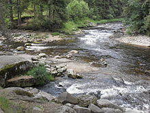
and Křemelná rivers. Together with the Vydra, which is its main source, the Otava is 134.8 km (83.8 mi) long, which makes it the
832:
847:
333:
literally means "second harvest of grass", but the name of the river is probably of pre-Slavic origin and the resemblance to the word
573:
389:, where it enters the Vltava River at the elevation of 348 m (1,142 ft). It is 134.8 km (83.8 mi) long. Its
169:
681:
385:, by the confluence of the Modravský potok, Filipohuťský potok and Roklanský potok at 975 m (3,199 ft) and flows to
730:
700:. It is still possible to find flakes of gold here. The sand panned for gold also gave the name to Písek (literally "sand").
653:
565:
374:
68:
377:, and is 111.7 km (69.4 mi) long. In a broader point of view, the Otava (as Vydra) arises in the territory of
669:
386:
759:
605:
867:
369:
From a water management point of view, the Otava and Vydra are two different rivers with separate numbering of
852:
310:
81:
432:
621:
593:
685:
641:
601:
396:
The Otava has many relatively significant tributaries, the following being the longest ones:
373:. The Otava itself is formed by the confluence of the Vydra and Křemelná in the territory of
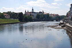
828:
709:
342:
341:, meaning "quick water". According to one theory, the name of the river is derived from the
361:
416:
382:
350:
282:
119:
625:
306:
76:
390:
294:
61:
783:
841:
520:
314:
103:
804:
581:
697:
712:. The course of the river is lined with many campsites for tourists and paddlers.
589:
665:
649:
637:
629:
597:
569:
140:
561:
448:
370:
184:
171:
298:
269:
734:
617:
577:
39:
17:
337:
is only coincidental. A possible but unproven origin is the
Germanic word
657:
645:
613:
557:
45:
680:
The drainage basin is rich in fishponds, especially in the area of the
585:
378:
115:
302:
261:
155:
661:
633:
360:
290:
265:
365:
Confluence of the Vydra and Křemelná rivers, forming the Otava
321:. Without the Vydra, it is 111.7 km (69.4 mi) long.
760:"Otava – skvělá řeka, kde vodácká doprava není příliš hustá"
696:
In earlier times, the banks of the Otava were popular for
393:
has an area of 3,826.9 km (1,477.6 sq mi).
564:. The river flows through the municipal territories of
556:
The largest settlements on the river are the towns of
784:"Základní charakteristiky toku Otava a jeho povodí"
257:
252:
238:
230:
218:
210:
200:
161:
149:
139:
125:
109:
99:
90:
67:
57:
52:
32:
786:(in Czech). T. G. Masaryk Water Research Institute
244:26.0 m/s (920 cu ft/s) near estuary
831:– Flood Warning and Forecasting Service of the
313:regions. It is formed by the confluence of the
8:
329:The origin of the name is unclear. The word
778:
776:
222:3,826.9 km (1,477.6 sq mi)
398:
721:
27:River in South Bohemian, Czech Republic
29:
7:
754:
752:
750:
863:Rivers of the South Bohemian Region
833:Czech Hydrometeorological Institute
25:
319:13th longest river in the country
38:
349:, which meant "river with many
163: • coordinates
1:
731:"Řeky si pojmenovali nejdřív"
91:Physical characteristics
729:Loucká, Pavla (1997-09-05).
305:River. It flows through the
214:134.8 km (83.8 mi)
202: • elevation
127: • elevation
829:River flow at Písek station
151: • location
111: • location
884:
858:Rivers of the Plzeň Region
708:The Otava is suitable for
240: • average
206:348 m (1,142 ft)
131:975 m (3,199 ft)
848:Tributaries of the Vltava
248:
226:
135:
95:
37:
762:(in Czech). CzechTourism
807:(in Czech). Město Písek
682:České Budějovice Basin
366:
286:
364:
185:49.02500°N 13.49639°E
253:Basin features
181: /
670:Zvíkovské Podhradí
506:Novosedelský potok
387:Zvíkovské Podhradí
367:
190:49.02500; 13.49639
549:
548:
275:
274:
16:(Redirected from
875:
816:
815:
813:
812:
805:"Historie města"
801:
795:
794:
792:
791:
780:
771:
770:
768:
767:
756:
745:
744:
742:
741:
726:
606:Střelské Hoštice
399:
371:river kilometres
241:
196:
195:
193:
192:
191:
186:
182:
179:
178:
177:
174:
128:
112:
42:
30:
21:
883:
882:
878:
877:
876:
874:
873:
872:
868:Bohemian Forest
838:
837:
825:
820:
819:
810:
808:
803:
802:
798:
789:
787:
782:
781:
774:
765:
763:
758:
757:
748:
739:
737:
728:
727:
723:
718:
706:
694:
686:Orlík Reservoir
678:
676:Bodies of water
554:
383:Bohemian Forest
359:
327:
239:
203:
189:
187:
183:
180:
175:
172:
170:
168:
167:
164:
152:
126:
120:Bohemian Forest
110:
86:
48:
28:
23:
22:
15:
12:
11:
5:
881:
879:
871:
870:
865:
860:
855:
850:
840:
839:
836:
835:
824:
823:External links
821:
818:
817:
796:
772:
746:
720:
719:
717:
714:
705:
702:
693:
690:
677:
674:
616:, Strakonice,
553:
550:
547:
546:
543:
540:
537:
533:
532:
529:
526:
523:
517:
516:
513:
510:
507:
503:
502:
499:
496:
493:
492:Brložský potok
489:
488:
485:
482:
479:
475:
474:
471:
468:
465:
461:
460:
457:
454:
451:
445:
444:
441:
438:
435:
429:
428:
425:
422:
419:
413:
412:
409:
406:
403:
391:drainage basin
358:
357:Characteristic
355:
326:
323:
311:South Bohemian
295:Czech Republic
273:
272:
259:
255:
254:
250:
249:
246:
245:
242:
236:
235:
232:
228:
227:
224:
223:
220:
216:
215:
212:
208:
207:
204:
201:
198:
197:
165:
162:
159:
158:
153:
150:
147:
146:
143:
137:
136:
133:
132:
129:
123:
122:
113:
107:
106:
101:
97:
96:
93:
92:
88:
87:
85:
84:
82:South Bohemian
79:
73:
71:
65:
64:
62:Czech Republic
59:
55:
54:
50:
49:
43:
35:
34:
26:
24:
14:
13:
10:
9:
6:
4:
3:
2:
880:
869:
866:
864:
861:
859:
856:
854:
853:Otava (river)
851:
849:
846:
845:
843:
834:
830:
827:
826:
822:
806:
800:
797:
785:
779:
777:
773:
761:
755:
753:
751:
747:
736:
732:
725:
722:
715:
713:
711:
710:river tourism
703:
701:
699:
691:
689:
687:
683:
675:
673:
671:
667:
663:
659:
655:
651:
647:
643:
639:
635:
631:
627:
623:
619:
615:
611:
607:
603:
599:
595:
594:Velké Hydčice
591:
587:
583:
579:
575:
571:
567:
563:
559:
551:
544:
541:
538:
536:Březový potok
535:
534:
530:
527:
524:
522:
519:
518:
514:
511:
508:
505:
504:
500:
497:
494:
491:
490:
486:
483:
480:
477:
476:
472:
469:
466:
463:
462:
458:
455:
452:
450:
447:
446:
442:
439:
436:
434:
431:
430:
426:
423:
420:
418:
415:
414:
410:
407:
404:
401:
400:
397:
394:
392:
388:
384:
380:
376:
372:
363:
356:
354:
352:
348:
344:
340:
336:
332:
324:
322:
320:
316:
312:
308:
304:
300:
296:
292:
288:
284:
280:
271:
267:
263:
260:
256:
251:
247:
243:
237:
233:
229:
225:
221:
217:
213:
209:
205:
199:
194:
166:
160:
157:
154:
148:
144:
142:
138:
134:
130:
124:
121:
117:
114:
108:
105:
102:
98:
94:
89:
83:
80:
78:
75:
74:
72:
70:
66:
63:
60:
56:
51:
47:
44:The Otava in
41:
36:
31:
19:
809:. Retrieved
799:
788:. Retrieved
764:. Retrieved
738:. Retrieved
733:(in Czech).
724:
707:
698:gold panning
695:
679:
610:Horní Poříčí
555:
395:
368:
346:
338:
334:
330:
328:
278:
276:
602:Horažďovice
552:Settlements
405:Length (km)
258:Progression
188: /
18:Otava river
842:Categories
811:2023-10-12
790:2023-10-12
766:2023-10-12
740:2023-10-12
716:References
622:Přešťovice
574:Dlouhá Ves
566:Hartmanice
562:Strakonice
375:Hartmanice
219:Basin size
176:13°29′47″E
640:, Písek,
590:Žichovice
402:Tributary
347:áth a ava
325:Etymology
299:tributary
297:, a left
270:North Sea
231:Discharge
173:49°1′30″N
58:Countries
666:Varvažov
658:Ostrovec
650:Vojníkov
646:Vrcovice
638:Kestřany
630:Čejetice
614:Katovice
598:Malý Bor
570:Rejštejn
478:Křemelná
464:Ostružná
408:River km
53:Location
704:Tourism
692:History
582:Dobršín
449:Volyňka
433:Lomnice
417:Blanice
381:in the
379:Modrava
339:Vatahva
301:of the
293:in the
289:) is a
287:Wottawa
116:Modrava
69:Regions
735:Vesmír
642:Čížová
626:Štěkeň
618:Slaník
578:Sušice
515:right
459:right
427:right
345:words
343:Celtic
303:Vltava
283:German
262:Vltava
234:
211:Length
156:Vltava
145:
100:Source
662:Oslov
634:Putim
558:Písek
545:left
528:111.7
521:Vydra
501:left
487:left
484:111.7
473:left
443:left
411:Side
351:fords
335:otava
331:otava
315:Vydra
307:Plzeň
291:river
279:Otava
141:Mouth
104:Vydra
77:Plzeň
46:Písek
33:Otava
668:and
654:Vráž
586:Rabí
560:and
542:62.9
539:21.3
525:23.1
512:60.5
509:24.3
498:35.5
495:27.0
481:30.3
470:88.9
467:41.3
456:54.6
453:46.1
440:24.9
437:59.3
424:32.8
421:94.7
309:and
277:The
266:Elbe
353:".
844::
775:^
749:^
672:.
664:,
660:,
656:,
652:,
648:,
644:,
636:,
632:,
628:,
624:,
620:,
612:,
608:,
604:,
600:,
596:,
592:,
588:,
584:,
580:,
576:,
572:,
568:,
531:–
285::
268:→
264:→
118:,
814:.
793:.
769:.
743:.
281:(
20:)
Text is available under the Creative Commons Attribution-ShareAlike License. Additional terms may apply.