281:
305:
269:
317:
293:
29:
245:
333:
257:
221:. The southern part was started in 1122, after the water level of the Rhine in Utrecht dropped because of the new dam at Wijk bij Duurstede. The ground excavated was used to raise the sides of the canal, to reduce the chance of flooding. When the city's system of locks was finished in 1275 the water level was constant, enabling the creation of permanently dry cellars and new quays at water level, hence the typical
217:) arrive to meet the original moat of the fortified town, and the Oudegracht goes from there into the center of town. Parts of the Oudegracht follow the original flow of the river Rhine, but there is some disagreement on what parts. The northern part is most likely an early canal (app. AD 1000) connecting the Rhine section to the river
280:
304:
268:
292:
408:
316:
418:
374:
398:
413:
233:) below street level. Warehouses used to line the canal. Today many of these warehouses have been converted into restaurants and cafés.
403:
393:
244:
367:
145:
105:
152:
112:
360:
256:
28:
38:
340:
344:
218:
332:
226:
194:
387:
210:
213:(a medieval canal reconnecting Utrecht to the newer main stream of the Rhine, the
202:
198:
49:
167:
154:
127:
114:
214:
97:
86:
34:
222:
206:
310:
View to de
Vismarkt-Choorstraat from bridge (de Maartensbrug)
348:
201:. It starts in the southeast of the city. Here the
183:
143:
103:
92:
81:
73:
68:
60:
55:
45:
21:
298:Shopping mall (de Planeet) and bridge (de Viebrug)
368:
193:, or "old canal", runs through the center of
8:
286:Bridge (de Jansbrug) with monumental houses
409:Buildings and structures in Utrecht (city)
375:
361:
18:
240:
7:
329:
327:
274:Monumental houses at the Oudegracht
419:Utrecht (province) geography stubs
347:. You can help Knowledge (XXG) by
14:
331:
315:
303:
291:
279:
267:
255:
243:
27:
205:(the original main bed of the
1:
16:Canal in Utrecht, Netherlands
399:Canals in Utrecht (province)
414:Transport in Utrecht (city)
250:Wharfs along the Oudegracht
435:
326:
322:Shop: de Winkel van Sinkel
404:History of Utrecht (city)
394:Canals in the Netherlands
26:
343:location article is a
230:
37:center, seen from the
64:2 km (1.2 miles)
262:Oudegracht by night
164: /
124: /
356:
355:
187:
186:
426:
377:
370:
363:
335:
328:
319:
307:
295:
283:
271:
259:
247:
179:
178:
176:
175:
174:
169:
168:52.097°N 5.115°E
165:
162:
161:
160:
157:
139:
138:
136:
135:
134:
129:
128:52.082°N 5.123°E
125:
122:
121:
120:
117:
31:
19:
434:
433:
429:
428:
427:
425:
424:
423:
384:
383:
382:
381:
323:
320:
311:
308:
299:
296:
287:
284:
275:
272:
263:
260:
251:
248:
239:
209:river) and the
172:
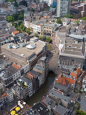
170:
166:
163:
158:
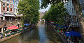
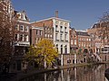
155:
153:
151:
150:
132:
130:
126:
123:
118:
115:
113:
111:
110:
41:
17:
12:
11:
5:
432:
430:
422:
421:
416:
411:
406:
401:
396:
386:
385:
380:
379:
372:
365:
357:
354:
353:
336:
325:
324:
321:
314:
312:
309:
302:
300:
297:
290:
288:
285:
278:
276:
273:
266:
264:
261:
254:
252:
249:
242:
238:
235:
185:
184:
181:
180:
148:
141:
140:
108:
101:
100:
94:
90:
89:
83:
79:
78:
75:
71:
70:
66:
65:
62:
58:
57:
56:Specifications
53:
52:
47:
43:
42:
32:
24:
23:
15:
13:
10:
9:
6:
4:
3:
2:
431:
420:
417:
415:
412:
410:
407:
405:
402:
400:
397:
395:
392:
391:
389:
378:
373:
371:
366:
364:
359:
358:
352:
350:
346:
342:
337:
334:
330:
318:
313:
306:
301:
294:
289:
282:
277:
270:
265:
258:
253:
246:
241:
236:
234:
232:
228:
224:
220:
216:
212:
208:
204:
200:
196:
192:
182:
177:
173:52.097; 5.115
149:
147:
142:
137:
133:52.082; 5.123
109:
107:
102:
99:
95:
91:
88:
84:
80:
76:
72:
67:
63:
59:
54:
51:
48:
44:
40:
36:
33:The canal in
30:
25:
20:
349:expanding it
338:
211:Vaartse Rijn
190:
188:
203:Kromme Rijn
199:Netherlands
171: /
146:coordinates
131: /
106:coordinates
82:Start point
50:Netherlands
388:Categories
191:Oudegracht
156:52°05′49″N
116:52°04′55″N
104:Beginning
22:Oudegracht
159:5°06′54″E
119:5°07′23″E
96:Northern
93:End point
85:Southern
77:Northwest
74:Direction
69:Geography
39:Dom Tower
341:Utrecht
237:Gallery
195:Utrecht
144:Ending
98:Utrecht
87:Utrecht
46:Country
35:Utrecht
231:werven
223:wharfs
197:, the
61:Length
339:This
227:Dutch
219:Vecht
207:Rhine
345:stub
189:The
215:Lek
390::
229::
376:e
369:t
362:v
351:.
225:(
Text is available under the Creative Commons Attribution-ShareAlike License. Additional terms may apply.