364:
404:
392:
380:
416:
31:
190:
The
Owendoher rises in two main branches. The larger branch flows from Glendoo / Glencullen valley, and meets the second, in turn formed from two streams, one sometimes called Kilakee Stream, from the slopes of Killakee Mountain, and the other Glendoo Stream, from west of Glendoo Mountain. The two
191:
branches merge near
Rockbrook Cemetery, along with another small stream from Woodbrook and Piperstown, and the Owendoher flows north to Ballyboden, and on to Rathfarnham, receiving the Whitechurch Stream.
209:
As the
Owendoher now passes, in its lower reaches, through heavily developed areas, it features many bridges - from where the river joins with the River Dodder to its source in the south:
534:
1002:
1046:
363:
479:
391:
502:
379:
403:
527:
415:
795:
883:
520:
868:
552:
1041:
950:
930:
925:
147:
198:
south of Bushy Park near the former settlement of
Butterfield, just south west of Rathfarnham village.
1051:
630:
990:
690:
666:
220:
171:
201:
There were historically a number of mills on the
Owendoher and its tributaries; none now operate.
780:
494:
831:
625:
543:
498:
475:
342:
986:
741:
649:
638:
823:
160:
116:
237:
Service road bridge (gated) - beside Boden Wood housing development to
Ballyboden Road
1035:
960:
917:
898:
717:
581:
167:
64:
965:
955:
945:
935:
903:
846:
836:
800:
775:
756:
746:
736:
730:
705:
700:
685:
680:
644:
370:
195:
179:
175:
126:
122:
102:
90:
878:
873:
863:
841:
790:
751:
723:
712:
695:
674:
661:
620:
615:
588:
94:
75:
30:
970:
940:
893:
858:
852:
810:
805:
767:
656:
574:
567:
98:
1017:
1004:
913:
888:
785:
607:
595:
331:
325:
319:
304:
277:
271:
267:
Service road bridge - Owendoher Haven housing development to
Ballyboden Road
261:
Service road bridge - Owendoher Lodge housing development to
Ballyboden Road
250:
243:
Service road bridge - Edenbrook Court housing development to
Ballyboden Road
214:
258:
Service road bridge - Hillside Park housing development to
Ballyboden Road
282:
Service road bridge - Springvale housing development to Edmonstown Road
240:
Service road bridge - Boden Wood housing development to Ballyboden Road
285:
Pedestrian bridge - Springvale housing development to Edmonstown Road
512:
300:
Service road bridge - Edmonstown national school to Edmonstown Road
516:
270:
Road bridge - Ballyboden Way to Taylors Lane/Ballyboden Road -
234:
Road bridge - Fairbrook Lawn to Willbrook Road/Ballyboden Road
474:. Dublin, Ireland: Rath Eanna Research. pp. 1–22 + map.
291:
Pedestrian bridge (wooden) - 2nd crossing at old clothes mill
472:
Ten Dozen Waters: The Rivers and Streams of County Dublin
288:
Pedestrian bridge (wooden) - Crossing at old clothes mill
166:, i.e. "The Little Dodder") is a small river in southern
246:
Pedestrian bridge - Willowbank Drive to Ballyboden Road
16:
River, largest tributary of the Dodder, Dublin, Ireland
276:
Road bridge - Scholarstown Road to Ballyboden Road -
231:
Pedestrian bridge - Fairbrook Lawn to Willbrook Road
228:
Service road bridge - Otterbrook housing development
225:
Pedestrian bridge - Glenbrook Park to Willbrook Road
912:
821:
765:
605:
559:
141:
133:
114:
109:
84:
74:
57:
49:
40:
23:
249:Road bridge - Ballyroan Road to Ballyboden Road -
985:indicate rivers which are partially or wholly in
397:Stone structures in the Owendoher near the M50.
528:
385:The Owendoher running under the M50 motorway.
8:
535:
521:
513:
309:Service road bridge - Kilmashogue Cemetery
324:Road bridge - Cruagh Road (upper end) -
318:Road bridge - Cruagh Road (lower end) -
435:
359:
312:Service road bridge - Private residence
297:Service road bridge - Private residence
264:Service road bridge - Private residence
63:Glendoo Mountain and Kilakee Mountain,
20:
421:The Owendoher meets the River Dodder.
7:
989:, with the rest being wholly in the
219:Road bridge - Butterfield Avenue -
497:. pp. 1–115, inc. many maps.
14:
330:Road bridge - Pine Forest Road -
213:Road bridge - Dodder View Road -
414:
409:Abandoned bridge near Ballyroan.
402:
390:
378:
362:
303:Road bridge - Edmonstown Road -
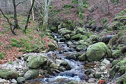
35:Owendoher River near Cruagh Wood
29:
1047:Rivers of South Dublin (county)
174:, the largest tributary of the
1:
442:
354:Photos of the Owendoher River
41:Physical characteristics
315:Road bridge - Tibradden Road
86: • location
59: • location
1068:
489:Sweeney, Clair L. (1991).
470:Doyle, Joseph W. (2010) .
453:
979:
550:
70:
45:
28:
194:The Owendoher joins the
143: • right
491:The Rivers of Dublin
373:on Glendoo Mountain.
178:, and a part of the
1014: /
991:Republic of Ireland
493:. Dublin, Ireland:
110:Basin features
495:Dublin Corporation
148:Whitechurch Stream
997:
996:
796:The Three Sisters
544:Rivers of Ireland
481:978-0-9566363-0-0
343:Rivers of Ireland
294:Road bridge - M50
153:
152:
1059:
1029:
1028:
1026:
1025:
1024:
1019:
1018:53.300°N 6.283°W
1015:
1012:
1011:
1010:
1007:
987:Northern Ireland
742:Shanganagh River
537:
530:
523:
514:
508:
485:
456:
451:
445:
440:
418:
406:
394:
382:
366:
255:Abandoned bridge
144:
119:
60:
33:
21:
1067:
1066:
1062:
1061:
1060:
1058:
1057:
1056:
1032:
1031:
1022:
1020:
1016:
1013:
1008:
1005:
1003:
1001:
1000:
998:
993:
981:River names in
975:
908:
822:Flowing to the
817:
766:Flowing to the
761:
606:Flowing to the
601:
555:
546:
541:
511:
505:
488:
482:
469:
465:
460:
459:
452:
448:
441:
437:
432:
427:
426:
425:
422:
419:
410:
407:
398:
395:
386:
383:
374:
367:
356:
355:
350:
340:
207:
188:
164:An Dothra Bheag
157:Owendoher River
142:
115:
87:
58:
36:
24:Owendoher River
17:
12:
11:
5:
1065:
1063:
1055:
1054:
1049:
1044:
1034:
1033:
1023:53.300; -6.283
995:
994:
980:
977:
976:
974:
973:
968:
963:
958:
953:
948:
943:
938:
933:
928:
922:
920:
910:
909:
907:
906:
901:
896:
891:
886:
881:
876:
871:
866:
861:
856:
849:
844:
839:
834:
828:
826:
819:
818:
816:
815:
814:
813:
808:
803:
793:
788:
783:
778:
772:
770:
763:
762:
760:
759:
754:
749:
744:
739:
734:
727:
720:
715:
710:
709:
708:
703:
698:
693:
688:
678:
671:
670:
669:
659:
654:
653:
652:
642:
635:
634:
633:
623:
618:
612:
610:
603:
602:
600:
599:
592:
585:
578:
571:
563:
561:
557:
556:
551:
548:
547:
542:
540:
539:
532:
525:
517:
510:
509:
503:
486:
480:
466:
464:
461:
458:
457:
446:
443:Sweeney (1991)
434:
433:
431:
428:
424:
423:
420:
413:
411:
408:
401:
399:
396:
389:
387:
384:
377:
375:
368:
361:
358:
357:
353:
352:
351:
349:
346:
339:
336:
335:
334:
328:
322:
316:
313:
310:
307:
301:
298:
295:
292:
289:
286:
283:
280:
274:
268:
265:
262:
259:
256:
253:
247:
244:
241:
238:
235:
232:
229:
226:
223:
217:
206:
203:
187:
184:
151:
150:
145:
139:
138:
135:
131:
130:
120:
112:
111:
107:
106:
88:
85:
82:
81:
78:
72:
71:
68:
67:
61:
55:
54:
51:
47:
46:
43:
42:
38:
37:
34:
26:
25:
15:
13:
10:
9:
6:
4:
3:
2:
1064:
1053:
1050:
1048:
1045:
1043:
1040:
1039:
1037:
1030:
1027:
992:
988:
984:
978:
972:
969:
967:
964:
962:
961:Mulkear River
959:
957:
954:
952:
949:
947:
944:
942:
939:
937:
934:
932:
929:
927:
924:
923:
921:
919:
915:
911:
905:
902:
900:
897:
895:
892:
890:
887:
885:
882:
880:
877:
875:
872:
870:
867:
865:
862:
860:
857:
855:
854:
850:
848:
845:
843:
840:
838:
835:
833:
830:
829:
827:
825:
820:
812:
809:
807:
804:
802:
799:
798:
797:
794:
792:
789:
787:
784:
782:
779:
777:
774:
773:
771:
769:
764:
758:
755:
753:
750:
748:
745:
743:
740:
738:
735:
733:
732:
728:
726:
725:
721:
719:
716:
714:
711:
707:
704:
702:
699:
697:
694:
692:
689:
687:
684:
683:
682:
679:
677:
676:
672:
668:
665:
664:
663:
660:
658:
655:
651:
648:
647:
646:
643:
641:
640:
636:
632:
629:
628:
627:
624:
622:
619:
617:
614:
613:
611:
609:
604:
598:
597:
593:
591:
590:
586:
584:
583:
579:
577:
576:
572:
570:
569:
565:
564:
562:
560:Flowing north
558:
554:
549:
545:
538:
533:
531:
526:
524:
519:
518:
515:
506:
504:0-9505301-4-X
500:
496:
492:
487:
483:
477:
473:
468:
467:
462:
455:
450:
447:
444:
439:
436:
429:
417:
412:
405:
400:
393:
388:
381:
376:
372:
365:
360:
347:
345:
344:
337:
333:
329:
327:
323:
321:
317:
314:
311:
308:
306:
302:
299:
296:
293:
290:
287:
284:
281:
279:
275:
273:
269:
266:
263:
260:
257:
254:
252:
248:
245:
242:
239:
236:
233:
230:
227:
224:
222:
218:
216:
212:
211:
210:
204:
202:
199:
197:
192:
185:
183:
181:
177:
173:
169:
168:County Dublin
165:
162:
158:
149:
146:
140:
136:
132:
128:
124:
121:
118:
113:
108:
104:
100:
97:, ultimately
96:
92:
89:
83:
79:
77:
73:
69:
66:
65:County Dublin
62:
56:
52:
48:
44:
39:
32:
27:
22:
19:
1042:River Dodder
999:
982:
966:Nenagh River
851:
729:
722:
673:
637:
594:
587:
580:
573:
566:
490:
471:
463:Bibliography
454:Doyle (2008)
449:
438:
369:The river's
341:
208:
200:
196:River Dodder
193:
189:
180:River Liffey
176:River Dodder
163:
156:
154:
127:River Dodder
123:River Liffey
117:River system
103:River Liffey
91:River Dodder
18:
1052:Rathfarnham
1021: /
931:Boyle River
926:Abbey River
914:Tributaries
832:Ballisodare
626:Broadmeadow
134:Tributaries
95:Rathfarnham
1036:Categories
781:Blackwater
768:Celtic Sea
650:Glencullen
639:Castletown
430:References
99:Dublin Bay
608:Irish Sea
824:Atlantic
338:See also
182:system.
1006:53°18′N
983:italics
918:Shannon
916:of the
899:Shannon
718:Naniken
582:Faughan
348:Gallery
205:Bridges
172:Ireland
1009:6°17′W
956:Maigue
946:Fergus
936:Brosna
904:Swilly
847:Corrib
837:Caragh
801:Barrow
776:Bandon
757:Vartry
747:Slaney
737:Santry
731:Quoile
706:Dodder
701:Poddle
686:Morell
681:Liffey
645:Dargle
501:
478:
371:source
186:Course
161:Irish:
137:
129:system
80:
53:
50:Source
884:Maine
879:Ferta
874:Laune
864:Feale
842:Clare
791:Mahon
752:Tolka
724:Newry
713:Mayne
696:Camac
675:Lagan
662:Glyde
621:Boyne
616:Avoca
589:Foyle
93:near
76:Mouth
971:Suck
951:Inny
941:Deel
894:Robe
869:Inny
859:Eske
853:Erne
811:Suir
806:Nore
657:Fane
631:Ward
575:Bush
568:Bann
553:List
499:ISBN
476:ISBN
332:R116
326:R116
320:R116
305:R116
278:R115
272:R113
251:R817
221:R114
215:R112
155:The
125:via
889:Moy
786:Lee
691:Rye
667:Dee
596:Roe
1038::
170:,
536:e
529:t
522:v
507:.
484:.
159:(
105:)
101:(
Text is available under the Creative Commons Attribution-ShareAlike License. Additional terms may apply.