49:
1071:
40:
374:. Almost all of the residents are scattered along the coast with the highlands mostly uninhabited jungle. However, there are some worker settlements in hilly areas which have mines and temporary settlements for clove farmers used during clove harvesting season. Infrastructure, especially in terms of modern medical facilities, is lacking.
349:
The population of the Obi
Islands Group was 53,182 people in mid 2023, with a population density of 17.45 people per square kilometre. All inhabitants on the Obi Island are migrants, as these islands had no indigenous population. The first groups to settle on Obi Island were the Buton, followed by
1034:
The dominant plantation products in the Obi
Islands are cloves, nutmeg, coconut, and pepper. The main economic potential of the islands s in the mining sector. The island has resources of gold, coal, nickel, cement, and petroleum. In 2016, provincial governor
254:), and often intermarried with the family of Ternate. However, at some point Obi became subject to Bacan. A decline in Bacan's population possibly caused the transfer of Obi's population to Bacan, which left the islands uninhabited by the mid-17th century.
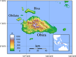
208:
is the largest island in the Obi
Islands archipelago. It is surrounded by many small islands, including Bisa Island (174.42 km), Obilatu Island (65.30 km), Gata-gata Island, Latu Island, Woka Island, and Tomini Island. Obi Island is bordered by the
225:
to the south. Obi Island's topography is generally in the form of hills with a short coastline. The hilly surface results in many springs and rivers. Lake Kapi, in the west, is its largest lake. The area was historically abundant in
301:
in the east. The total area of the main island is about 2,800 square kilometres (1,100 sq mi). Obi Island and the surrounding small islands are divided into five administrative districts (
313:), with villages further subdivided into hamlets. Of the five districts, three comprise the main Obi Island, although each district also includes neighbouring smaller islands -
191:. With a total area of 3,048.08 km, they had a population of 41,455 at the 2010 Census and 50,760 at the 2020 Census. The official estimate as at mid 2023 was 53,182.
405:), listed below with their areas and their populations at the 2020 Census. The administrative centres of the five districts are denoted by asterisks.
1418:
1677:
1672:
1293:
1266:
1205:
1167:
238:
The Obi
Islands were an independent kingdom during the 14th century, who were near-equal in importance with the other Malukuan kingdoms (
1662:
1667:
1355:
1367:
1039:
successfully negotiated for the China-based
Jinchun Group to build a 620 million dollar nickel smelter on the main island.
1411:
1283:
258:
1404:
286:
329:
includes
Obilatu and Belangbelang Islands to the west of Obi Island, together with the southern part (
1636:
1478:
386:
247:
239:
1516:
337:
includes the main part of Bisa Island to the north of Obi Island, together with the northern part (
298:
251:
164:
26:
1310:
1222:
1546:
1036:
325:
also includes Gomumu Island to the south. The other two districts include no part of Obi Island;
262:
243:
1498:
1289:
1262:
1201:
1163:
274:
257:
On May 9, 1682, Obi, Obilatu, Gomumu, Tapat, and Bisa were sold by the Sultan of Bacan to the
139:
1626:
1254:
1193:
1155:
217:
to the south, and the Obi Strait to the north and east. The major islands closest to it are
1311:"Ternate: The Residency and its Sultanate (Bijdragen tot de kennis der Residentie Ternate)"
1223:"Ternate: The Residency and its Sultanate (Bijdragen tot de kennis der Residentie Ternate)"
1631:
1606:
382:
378:
294:
270:
119:
115:
1427:
1076:
367:
64:
48:
1656:
1551:
1536:
1531:
1443:
266:
1616:
1591:
1571:
1541:
1511:
1435:
290:
222:
218:
184:
176:
100:
1621:
1556:
1458:
39:
1596:
1066:
210:
200:
143:
74:
1382:
1369:
1601:
1448:
1285:
Pirates, Ports, and Coasts in Asia: Historical and
Contemporary Perspectives
1070:
214:
188:
172:
131:
88:
1611:
1506:
1483:
1468:
1159:
351:
317:
includes the southern part of Bisa Island to the north of Obi Island,
1581:
1561:
1488:
1463:
1258:
1197:
359:
355:
1149:
1641:
1586:
1576:
1566:
1521:
1453:
1248:
1187:
363:
1396:
1151:
The World of Maluku: eastern
Indonesia in the early modern period
1526:
371:
227:
180:
1400:
1342:
1340:
1250:
The
Propagation of Islam in the Indonesian-Malay Archipelago
1189:
The
Propagation of Islam in the Indonesian-Malay Archipelago
1123:
1121:
1119:
408:
1253:. Malaysian Sociological Research Institute. p. 277.
1192:. Malaysian Sociological Research Institute. p. 255.
305:), which are sub-divided into 34 administrative villages (
273:
moved to the islands. In 1876, the islands were declared
1095:
London, George Philip and Son map 'East Indies' pp.91-92
397:
The five districts are sub-divided into villages (rural
1356:
China`s Jinchun to in vest Rp9 trillion in North Maluku
289:. The archipelago is directly bordered by the rest of
1288:. Institute of Southeast Asian Studies. p. 205.
1497:
1434:
1358:. Antara, 16 July 2016. Accessed 18 September 2017.
130:
125:
111:
106:
96:
80:
70:
60:
55:
24:
1127:Badan Pusat Statistik, Jakarta, 28 February 2024,
1282:Kleinen, John; Osseweijer, Manon (2010-08-10).
1412:
8:
1129:Kabupaten Halmahera Selatan Dalam Angka 2024
19:
1042:Some mining companies in this islands are:
16:Group of islands in North Maluku, Indonesia
1419:
1405:
1397:
1154:. University of Hawaii Press. p. 85.
705:
412:
47:
38:
18:
321:includes Tobalai Island to the east, and
377:The languages spoken on the islands are
1084:
265:. The islands became a center for the
1346:Badan Pusat Statistik, Jakarta, 2021.
1334:Badan Pusat Statistik, Jakarta, 2021.
1113:Badan Pusat Statistik, Jakarta, 2021.
7:
1181:
1179:
1143:
1141:
1139:
1137:
1104:Biro Pusat Statistik, Jakarta, 2011.
293:Province to the north and west, by
171:) are a group of 42 islands in the
14:
1069:
1091:Goodall, George (Editor)(1943)
350:immigrants from Tobelo-Galela,
1:
1678:Populated places in Indonesia
1673:Islands of the Maluku Islands
1247:Gordon, Alijah (Ed ) (2001).
1186:Gordon, Alijah (Ed ) (2001).
1093:Philips' International Atlas
285:The Obi Islands are part of
269:chiefs, and many Tobelo and
1148:Andaya, Leonard Y. (1993).
1012:
1007:
992:
989:
979:
976:
965:
962:
952:
949:
938:
935:
925:
922:
912:
909:
897:
892:
877:
874:
864:
861:
851:
848:
838:
835:
823:
818:
803:
800:
790:
787:
777:
774:
764:
761:
751:
748:
738:
735:
695:
690:
675:
672:
662:
659:
649:
646:
636:
633:
623:
620:
610:
607:
597:
594:
584:
581:
571:
568:
556:
551:
536:
533:
523:
520:
510:
507:
497:
494:
484:
481:
471:
468:
458:
455:
445:
442:
1694:
1663:Archipelagoes of Indonesia
1131:(Katalog-BPS 1102001.8204)
1668:Landforms of North Maluku
333:) of Tapat Island, while
85:
46:
37:
1049:Halmahera Jaya Feronikel
1046:Halmahera Persada Lygend
1055:Trimegah Bangun Persada
287:South Halmahera Regency
385:, which belong to the
126:Additional information
1309:De Clercq, F. T. A.
1221:De Clercq, F. T. A.
387:West Papuan language
297:in the south and by
1379: /
1052:Megah Surya Pratiwi
341:) of Tapat Island.
299:West Papua Province
21:
1037:Abdul Ghani Kasuba
335:Obi Utara District
327:Obi Barat District
323:Obi Selatan Island
319:Obi Timur District
1650:
1649:
1383:1.500°S 127.750°E
1295:978-981-4279-07-9
1268:978-983-99866-2-4
1207:978-983-99866-2-4
1169:978-0-8248-1490-8
1058:Wanatiara Persada
1026:
1025:
1019:
1018:
702:
701:
221:to the north and
213:to the west, the
153:
152:
1685:
1421:
1414:
1407:
1398:
1394:
1393:
1391:
1390:
1389:
1384:
1380:
1377:
1376:
1375:
1372:
1359:
1353:
1347:
1344:
1335:
1332:
1326:
1325:
1323:
1322:
1306:
1300:
1299:
1279:
1273:
1272:
1244:
1238:
1237:
1235:
1234:
1218:
1212:
1211:
1183:
1174:
1173:
1145:
1132:
1125:
1114:
1111:
1105:
1102:
1096:
1089:
1079:
1074:
1073:
706:
413:
409:
339:Pasir Putih desa
51:
42:
22:
1693:
1692:
1688:
1687:
1686:
1684:
1683:
1682:
1653:
1652:
1651:
1646:
1499:Maluku province
1493:
1430:
1425:
1388:-1.500; 127.750
1387:
1385:
1381:
1378:
1373:
1370:
1368:
1366:
1365:
1363:
1362:
1354:
1350:
1345:
1338:
1333:
1329:
1320:
1318:
1308:
1307:
1303:
1296:
1281:
1280:
1276:
1269:
1246:
1245:
1241:
1232:
1230:
1220:
1219:
1215:
1208:
1185:
1184:
1177:
1170:
1147:
1146:
1135:
1126:
1117:
1112:
1108:
1103:
1099:
1090:
1086:
1075:
1068:
1065:
1032:
1027:
725:
723:
718:
713:
432:
430:
425:
420:
395:
347:
295:Maluku Province
283:
236:
197:
187:, and south of
159:(also known as
149:
92:
33:
32:
17:
12:
11:
5:
1691:
1689:
1681:
1680:
1675:
1670:
1665:
1655:
1654:
1648:
1647:
1645:
1644:
1639:
1634:
1629:
1624:
1619:
1614:
1609:
1604:
1599:
1594:
1589:
1584:
1579:
1574:
1569:
1564:
1559:
1554:
1549:
1544:
1539:
1534:
1529:
1524:
1519:
1514:
1509:
1503:
1501:
1495:
1494:
1492:
1491:
1486:
1481:
1476:
1471:
1466:
1461:
1456:
1451:
1446:
1440:
1438:
1432:
1431:
1428:Maluku Islands
1426:
1424:
1423:
1416:
1409:
1401:
1361:
1360:
1348:
1336:
1327:
1315:www.sil.si.edu
1301:
1294:
1274:
1267:
1239:
1227:www.sil.si.edu
1213:
1206:
1175:
1168:
1133:
1115:
1106:
1097:
1083:
1082:
1081:
1080:
1077:Islands portal
1064:
1061:
1060:
1059:
1056:
1053:
1050:
1047:
1031:
1028:
1024:
1023:
1017:
1016:
1011:
1006:
1001:
995:
994:
991:
988:
986:
982:
981:
978:
975:
972:
971:Madapolo Timur
968:
967:
964:
961:
959:
955:
954:
951:
948:
945:
944:Madapolo Barat
941:
940:
937:
934:
932:
928:
927:
924:
921:
919:
915:
914:
911:
908:
906:
902:
901:
896:
891:
886:
880:
879:
876:
873:
871:
867:
866:
863:
860:
858:
854:
853:
850:
847:
845:
841:
840:
837:
834:
832:
828:
827:
822:
817:
812:
806:
805:
802:
799:
797:
793:
792:
789:
786:
784:
780:
779:
776:
773:
771:
767:
766:
763:
760:
758:
754:
753:
750:
747:
745:
741:
740:
737:
734:
732:
728:
727:
720:
715:
710:
703:
700:
699:
694:
689:
684:
678:
677:
674:
671:
669:
665:
664:
661:
658:
656:
652:
651:
648:
645:
643:
639:
638:
635:
632:
630:
626:
625:
622:
619:
617:
613:
612:
609:
606:
604:
600:
599:
596:
593:
591:
587:
586:
583:
580:
578:
574:
573:
570:
567:
565:
561:
560:
555:
550:
545:
539:
538:
535:
532:
530:
526:
525:
522:
519:
517:
513:
512:
509:
506:
504:
500:
499:
496:
493:
491:
487:
486:
483:
480:
478:
474:
473:
470:
467:
465:
461:
460:
457:
454:
452:
448:
447:
444:
441:
439:
435:
434:
427:
422:
417:
407:
394:
391:
368:South Sulawesi
346:
343:
282:
281:Administration
279:
235:
232:
204:, also called
196:
193:
151:
150:
148:
147:
136:
134:
128:
127:
123:
122:
113:
109:
108:
104:
103:
98:
94:
93:
86:
83:
82:
81:Administration
78:
77:
72:
68:
67:
65:Southeast Asia
62:
58:
57:
53:
52:
44:
43:
35:
34:
30:
25:
15:
13:
10:
9:
6:
4:
3:
2:
1690:
1679:
1676:
1674:
1671:
1669:
1666:
1664:
1661:
1660:
1658:
1643:
1640:
1638:
1635:
1633:
1630:
1628:
1625:
1623:
1620:
1618:
1615:
1613:
1610:
1608:
1605:
1603:
1600:
1598:
1595:
1593:
1590:
1588:
1585:
1583:
1580:
1578:
1575:
1573:
1570:
1568:
1565:
1563:
1560:
1558:
1555:
1553:
1550:
1548:
1545:
1543:
1540:
1538:
1535:
1533:
1530:
1528:
1525:
1523:
1520:
1518:
1515:
1513:
1510:
1508:
1505:
1504:
1502:
1500:
1496:
1490:
1487:
1485:
1482:
1480:
1477:
1475:
1472:
1470:
1467:
1465:
1462:
1460:
1457:
1455:
1452:
1450:
1447:
1445:
1442:
1441:
1439:
1437:
1433:
1429:
1422:
1417:
1415:
1410:
1408:
1403:
1402:
1399:
1395:
1392:
1357:
1352:
1349:
1343:
1341:
1337:
1331:
1328:
1317:. p. 134
1316:
1312:
1305:
1302:
1297:
1291:
1287:
1286:
1278:
1275:
1270:
1264:
1260:
1256:
1252:
1251:
1243:
1240:
1229:. p. 116
1228:
1224:
1217:
1214:
1209:
1203:
1199:
1195:
1191:
1190:
1182:
1180:
1176:
1171:
1165:
1161:
1157:
1153:
1152:
1144:
1142:
1140:
1138:
1134:
1130:
1124:
1122:
1120:
1116:
1110:
1107:
1101:
1098:
1094:
1088:
1085:
1078:
1072:
1067:
1062:
1057:
1054:
1051:
1048:
1045:
1044:
1043:
1040:
1038:
1029:
1022:
1015:
1010:
1005:
1002:
1000:
997:
996:
987:
984:
983:
974:East Madapolo
973:
970:
969:
960:
957:
956:
947:West Madapolo
946:
943:
942:
933:
930:
929:
920:
917:
916:
907:
904:
903:
900:
895:
890:
887:
885:
882:
881:
872:
869:
868:
859:
856:
855:
846:
843:
842:
833:
830:
829:
826:
821:
816:
813:
811:
808:
807:
798:
795:
794:
785:
782:
781:
772:
769:
768:
759:
756:
755:
746:
743:
742:
733:
730:
729:
721:
716:
711:
708:
707:
704:
698:
693:
688:
685:
683:
680:
679:
670:
667:
666:
657:
654:
653:
644:
641:
640:
631:
628:
627:
618:
615:
614:
605:
602:
601:
592:
589:
588:
579:
576:
575:
566:
563:
562:
559:
554:
549:
546:
544:
541:
540:
531:
528:
527:
518:
515:
514:
505:
502:
501:
492:
489:
488:
479:
476:
475:
466:
463:
462:
453:
450:
449:
440:
437:
436:
428:
423:
418:
415:
414:
411:
410:
406:
404:
400:
392:
390:
388:
384:
380:
375:
373:
369:
365:
361:
357:
353:
344:
342:
340:
336:
332:
328:
324:
320:
316:
312:
308:
304:
300:
296:
292:
288:
280:
278:
276:
272:
268:
264:
260:
255:
253:
249:
245:
241:
233:
231:
229:
224:
220:
216:
212:
207:
206:Obira Island,
203:
202:
194:
192:
190:
186:
182:
178:
174:
170:
169:Kepulauan Obi
166:
162:
158:
145:
141:
138:
137:
135:
133:
129:
124:
121:
117:
114:
110:
105:
102:
99:
95:
91:
90:
84:
79:
76:
73:
71:Major islands
69:
66:
63:
59:
54:
50:
45:
41:
36:
31:Kepulauan Obi
28:
23:
1473:
1436:North Maluku
1364:
1351:
1330:
1319:. Retrieved
1314:
1304:
1284:
1277:
1249:
1242:
1231:. Retrieved
1226:
1216:
1188:
1150:
1128:
1109:
1100:
1092:
1087:
1041:
1033:
1020:
1013:
1008:
1003:
998:
898:
893:
888:
883:
824:
819:
814:
809:
757:Alam Kenanga
696:
691:
686:
681:
557:
552:
547:
542:
402:
398:
396:
376:
348:
345:Demographics
338:
334:
330:
326:
322:
318:
315:Obi District
314:
310:
306:
302:
291:North Maluku
284:
263:rijksdaalder
256:
237:
219:Bacan Island
205:
199:
198:
177:North Maluku
175:province of
168:
160:
156:
154:
107:Demographics
101:North Maluku
87:
1386: /
1160:10125/33430
905:Pasir Putih
783:Alam Pelita
770:Soa Sangaji
543:Obi Selatan
179:, north of
157:Obi Islands
27:Native name
20:Obi Islands
1657:Categories
1321:2024-04-15
1233:2024-04-15
958:Madapolo *
668:Air Mangga
516:Ocimaloleo
477:Wayaloar *
401:and urban
277:property.
275:government
230:and fish.
211:Maluku Sea
201:Obi Island
173:Indonesian
165:Indonesian
75:Obi Island
1602:Nusa Laut
1449:Halmahera
1259:1828/8122
1198:1828/8122
1004:North Obi
999:Obi Utara
884:Obi Timur
810:Obi Barat
744:Jikohai *
731:Manatahan
548:South Obi
403:kelurahan
331:Tapa desa
311:kelurahan
303:kecamatan
215:Seram Sea
195:Geography
189:Halmahera
144:UTC+09:00
132:Time zone
112:Languages
89:Indonesia
56:Geography
1637:Watubela
1627:Tanimbar
1374:127°45′E
889:East Obi
815:West Obi
712:English
692:1,073.15
603:Laiwui *
590:Jikotamo
553:1,083.48
419:English
393:Villages
389:family.
261:for 620
97:Province
61:Location
1632:Tayandu
1612:Saparua
1507:Ambelau
1484:Ternate
1469:Morotai
1030:Economy
985:Waringi
717:Area in
642:Akegula
577:Sambiki
529:Gambaru
424:Area in
352:Ternate
248:Ternate
240:Jailolo
234:History
161:Ombirah
1607:Romang
1582:Manipa
1562:Kelang
1552:Haruku
1547:Gorong
1489:Tidore
1464:Makian
1371:1°30′S
1292:
1265:
1204:
1166:
1021:
1009:160.69
980:1,335
966:2,460
953:1,820
931:Galala
913:1,138
894:636.23
878:1,253
875:222.00
857:Susepe
849:180.40
839:1,521
836:184.60
752:1,543
739:1,271
724:Census
697:20,538
673:129.50
663:4,533
660:133.79
655:Kawasi
650:1,024
637:2,368
634:371.37
624:1,531
611:2,294
598:3,147
585:2,374
572:2,310
564:Anggai
558:12,178
521:157.78
508:296.36
495:142.54
485:3,263
482:199.54
472:3,145
469:118.40
464:Sologi
459:2,712
446:1,038
431:Census
383:Tobelo
379:Galela
360:Makian
356:Tidore
271:Galela
267:Tobelo
252:Tidore
120:Tobelo
116:Galela
1642:Wetar
1622:Serua
1617:Seram
1587:Manuk
1577:Liran
1567:Kisar
1542:Damar
1537:Banda
1532:Babar
1522:Boano
1512:Ambon
1454:Kayoa
1444:Bacan
1063:Notes
1014:9,128
990:19.50
977:29.90
963:19.70
950:21.10
936:31.90
923:24.50
910:14.10
899:3,705
862:49.20
831:Sum *
825:5,211
820:94.53
801:14.55
788:16.54
775:17.32
762:12.20
749:10.87
736:17.71
726:2020
647:27.66
621:14.16
616:Buton
608:44.32
595:76.03
582:68.58
569:45.18
534:83.23
456:12.03
443:11.14
438:Loleo
433:2020
364:Kayoa
244:Bacan
223:Ambon
185:Ceram
1597:Nila
1572:Leti
1527:Buru
1479:Sula
1459:Moti
1290:ISBN
1263:ISBN
1202:ISBN
1164:ISBN
993:863
939:684
926:828
870:Wooi
865:233
852:698
844:Kelo
804:533
796:Tapa
791:978
778:563
765:323
722:Popn
714:name
709:Name
676:957
629:Baru
537:789
524:743
511:166
503:Bobo
498:322
490:Fluk
451:Mano
429:Popn
421:name
416:Name
399:desa
381:and
372:Java
370:and
309:and
307:desa
228:sago
183:and
181:Buru
155:The
1592:Moa
1557:Kai
1517:Aru
1474:Obi
1255:hdl
1194:hdl
1156:hdl
918:Cap
687:Obi
682:Obi
259:VOC
140:EIT
1659::
1339:^
1313:.
1261:.
1225:.
1200:.
1178:^
1162:.
1136:^
1118:^
719:km
426:km
366:,
362:,
358:,
354:,
250:,
246:,
242:,
167::
163:,
118:,
29::
1420:e
1413:t
1406:v
1324:.
1298:.
1271:.
1257::
1236:.
1210:.
1196::
1172:.
1158::
146:)
142:(
Text is available under the Creative Commons Attribution-ShareAlike License. Additional terms may apply.