149:
657:
26:
45:
52:
638:
228:
Pioneer farmers found the glacial outwash sandy soil poor for farming and many farms were abandoned, reverting to state ownership for non-payment of taxes. Many clearings within the Ogemaw Hills
Pathway trail system are old farm fields being reclaimed by the forest and fence lines, rock piles, and
224:
Ogemaw State Forest was administratively created in 1914 under the leadership of
Michigan State Forester Marcus Schaaf and consisted of 4,160 acres (1,680 ha). A fifty-foot steel fire lookout tower was constructed in the fall of 1914 and the footings are still visible. Grover Zettle was named
240:
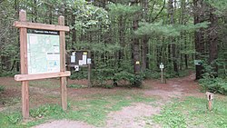
The trail system features a well defined trail-tread and is blazed by blue triangle markers. The trail system features 26 intersection posts consisting of location number, a trail map, direction of travel arrows, and trail difficulty markers from easiest to most difficult of green circle, blue
171:. The Pathway offers approximately 15 miles of trails open to hiking, cross country skiing, and biking. The Ogemaw Hills Pathway Council non-profit manages the trail system and grooms the trails for
722:
727:
698:
443:
95:
232:
In 1978 the fifty three state forests were consolidated into six forest
Districts and the Ogemaw State Forest became part of the Au Sable State Forest.
410:
130:
44:
627:
186:
The Ogemaw Hills
Pathway trail system traverses a well defined ridge of hills north of West Branch, Michigan referred to by geologists as the
691:
587:
436:
717:
367:
258:
684:
429:
178:
Ogemaw Hills
Pathway foot-travel pathway designation bans all motorized vehicle travel and equine use of the trail system.
562:
285:
31:
148:
617:
597:
537:
656:
592:
577:
406:
140:
664:
622:
512:
168:
72:
497:
492:
532:
187:
400:
164:
160:
83:
557:
487:
25:
482:
467:
552:
517:
199:
172:
572:
542:
502:
477:
472:
191:
415:
668:
607:
507:
567:
522:
396:
206:
341:
547:
711:
602:
209:
195:
527:
213:
212:
that formed in front of the melting
Saginaw Lobe and retreated into present day
203:
314:
612:
110:
97:
421:
456:
286:"Enjoy a quiet trail: Four hidden gems to cross-country ski in Michigan"
637:
452:
147:
425:
342:"A Short History of the Michigan State Forests: The Early Days"
368:"Ogemaw State Forest turns 100 with rededication ceremony"
319:
GEO 333: Geography of
Michigan and the Great Lakes Region
259:"Cross country ski event to benefit Ogemaw Hills Pathway"
202:. The West Branch Moraine marks a northern border of the
672:
225:superintendent of the Ogemaw State Forest in 1914.
136:
126:
89:
79:
67:
18:
692:
437:
8:
51:
723:Protected areas of Ogemaw County, Michigan
699:
685:
444:
430:
422:
308:
306:
159:is a foot-travel pathway located north of
15:
728:Lower Peninsula, Michigan geography stubs
411:Michigan Department of Natural Resources
346:Michigan Forests Forever Teacher's Guide
131:Michigan Department of Natural Resources
250:
59:Location within the state of Michigan
7:
653:
651:
66:
671:. You can help Knowledge (XXG) by
14:
284:Semion, Bill (30 December 2011).
655:
636:
50:
43:
24:
78:
397:Ogemaw Hills Pathway Trail Map
152:Ogemaw Hills Pathway trailhead
30:Fairview Road entrance within
1:
241:square, and black diamonds.
321:. Michigan State University
744:
650:
588:Paul Henry–Thornapple Rail
348:. Michigan Forests Forever
229:foundations can be found.
718:Hiking trails in Michigan
634:
578:North Western State Trail
463:
315:"Major Glacial Ice Lobes"
38:
23:
372:The Ogemaw County Herald
263:The Ogemaw County Herald
665:Ogemaw County, Michigan
563:Michigan Shore-to-Shore
513:Iron Ore Heritage Trail
169:Ogemaw County, Michigan
111:44.350430°N 84.225906°W
73:Ogemaw County, Michigan
667:location article is a
290:The Grand Rapids Press
194:outwash formed by the
153:
401:West Branch, Michigan
165:Au Sable State Forest
161:West Branch, Michigan
151:
116:44.350430; -84.225906
84:West Branch, Michigan
598:Pere Marquette State
583:Ogemaw Hills Pathway
553:Manistee River Trail
416:Ogemaw Hills Pathway
407:Ogemaw Hills Pathway
200:Laurentide Ice Sheet
173:cross country skiing
157:Ogemaw Hills Pathway
19:Ogemaw Hills Pathway
593:Pere Marquette Rail
313:Schaetzl, Randall.
192:recessional moraine
188:West Branch Moraine
127:Governing body
107: /
265:. 12 February 2014
154:
680:
679:
645:
644:
623:Waterloo-Pinckney
418:, Up North Trails
146:
145:
80:Nearest city
71:Lower Peninsula,
32:Klacking Township
735:
701:
694:
687:
659:
652:
640:
493:Greenstone Ridge
446:
439:
432:
423:
384:
383:
381:
379:
374:. 21 August 2014
364:
358:
357:
355:
353:
337:
331:
330:
328:
326:
310:
301:
300:
298:
296:
281:
275:
274:
272:
270:
255:
141:Official website
122:
121:
119:
118:
117:
112:
108:
105:
104:
103:
100:
54:
53:
47:
28:
16:
743:
742:
738:
737:
736:
734:
733:
732:
708:
707:
706:
705:
648:
646:
641:
632:
459:
450:
403:Visitors Bureau
393:
388:
387:
377:
375:
366:
365:
361:
351:
349:
339:
338:
334:
324:
322:
312:
311:
304:
294:
292:
283:
282:
278:
268:
266:
257:
256:
252:
247:
238:
222:
184:
115:
113:
109:
106:
101:
98:
96:
94:
93:
63:
62:
61:
60:
57:
56:
55:
34:
12:
11:
5:
741:
739:
731:
730:
725:
720:
710:
709:
704:
703:
696:
689:
681:
678:
677:
660:
643:
642:
635:
633:
631:
630:
625:
620:
615:
610:
605:
600:
595:
590:
585:
580:
575:
570:
565:
560:
555:
550:
545:
540:
535:
530:
525:
520:
515:
510:
505:
500:
495:
490:
485:
480:
475:
470:
464:
461:
460:
451:
449:
448:
441:
434:
426:
420:
419:
413:
404:
392:
391:External links
389:
386:
385:
359:
332:
302:
276:
249:
248:
246:
243:
237:
234:
221:
218:
183:
180:
144:
143:
138:
134:
133:
128:
124:
123:
91:
87:
86:
81:
77:
76:
69:
65:
64:
58:
49:
48:
42:
41:
40:
39:
36:
35:
29:
21:
20:
13:
10:
9:
6:
4:
3:
2:
740:
729:
726:
724:
721:
719:
716:
715:
713:
702:
697:
695:
690:
688:
683:
682:
676:
674:
670:
666:
661:
658:
654:
649:
639:
629:
626:
624:
621:
619:
616:
614:
611:
609:
606:
604:
603:Plaster Creek
601:
599:
596:
594:
591:
589:
586:
584:
581:
579:
576:
574:
573:North Country
571:
569:
566:
564:
561:
559:
556:
554:
551:
549:
546:
544:
543:Lansing River
541:
539:
536:
534:
533:Lake Superior
531:
529:
526:
524:
521:
519:
516:
514:
511:
509:
506:
504:
503:Horseshoe Bay
501:
499:
496:
494:
491:
489:
486:
484:
481:
479:
478:Betsie Valley
476:
474:
473:Boardman Lake
471:
469:
466:
465:
462:
458:
454:
453:Hiking trails
447:
442:
440:
435:
433:
428:
427:
424:
417:
414:
412:
408:
405:
402:
398:
395:
394:
390:
373:
369:
363:
360:
347:
343:
340:Moore, Mike.
336:
333:
320:
316:
309:
307:
303:
291:
287:
280:
277:
264:
260:
254:
251:
244:
242:
235:
233:
230:
226:
219:
217:
215:
211:
208:
205:
201:
197:
193:
189:
181:
179:
176:
174:
170:
166:
162:
158:
150:
142:
139:
135:
132:
129:
125:
120:
92:
88:
85:
82:
74:
70:
46:
37:
33:
27:
22:
17:
673:expanding it
662:
647:
582:
518:Jordan River
498:High Country
376:. Retrieved
371:
362:
350:. Retrieved
345:
335:
323:. Retrieved
318:
293:. Retrieved
289:
279:
267:. Retrieved
262:
253:
239:
236:Trail System
231:
227:
223:
210:Lake Saginaw
196:Saginaw Lobe
185:
177:
156:
155:
558:Marble Head
378:26 February
352:26 February
325:26 February
295:26 February
269:26 February
214:Saginaw Bay
204:Pleistocene
163:within the
114: /
90:Coordinates
712:Categories
628:White Pine
608:State Line
508:Iron Belle
483:Dune Climb
468:Bay de Noc
245:References
207:proglacial
102:84°13′33″W
99:44°21′02″N
618:Van Buren
568:Musketawa
538:Lakelands
523:Kal-Haven
488:Fox River
182:Geography
548:Leelanau
457:Michigan
68:Location
220:History
198:of the
137:Website
663:This
669:stub
613:TART
528:Kent
380:2017
354:2017
327:2017
297:2017
271:2017
190:, a
455:in
167:in
75:USA
714::
409:,
399:,
370:.
344:.
317:.
305:^
288:.
261:.
216:.
175:.
700:e
693:t
686:v
675:.
445:e
438:t
431:v
382:.
356:.
329:.
299:.
273:.
Text is available under the Creative Commons Attribution-ShareAlike License. Additional terms may apply.