529:
482:
40:
767:
495:
26:
592:
501:
430:
399:
232:
217:
110:
86:
563:
535:
488:
455:
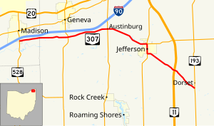
318:. SR 46 and SR 307 head due south concurrent, into downtown Jefferson, passing through commercial and residential properties. After downtown Jefferson SR 307 leaves SR 46. SR 307 heads southeast leaving Jefferson, passing through woodland and farmland. The highway has an interchange with
298:
SR 307 begins at a T-intersection with SR 528. The route heads east as a two-lane highway passing through farmland and woodland, with some houses. The highway has an intersection with
286:
SR 307 was commissioned in the mid-1930s and the route was swapped with another state route one year later. The route was extended in the later 1930s, to an intersection with
1119:
417:
1114:
442:
1085:
550:
327:
386:
185:
97:
833:
652:
53:
346:. In 1934 SR 307 swapped alignments with SR 84. The route was extended west to SR 84, 4 miles (6.4 km) east of
1109:
656:
842:
310:. After Austinburg, SR 307 turns towards the southeast, still passing through farmland and woodland. The route enters
195:
190:
1094:
603:
412:
323:
276:
268:
160:
343:
595:
509:
433:
402:
350:, in 1937. Between 1962 and 1964, SR 307 between SR 84 and SR 528 was decommissioned.
299:
235:
220:
113:
89:
566:
539:
505:
458:
319:
315:
303:
287:
795:
622:
1076:
1032:
993:
954:
919:
880:
804:
734:
690:
381:
347:
200:
156:
570:
307:
846:
574:
468:
311:
280:
117:
1023:
984:
945:
910:
871:
725:
681:
1103:
339:
272:
256:
136:
93:
599:
803:(Map). c. 1:570,240. Columbus: Ohio Department of Transportation. § Q1–R2.
772:
260:
923:
1031:(Map). c. 1:563,200. Columbus: Ohio Department of Highways. § N3–O3.
992:(Map). c. 1:563,200. Columbus: Ohio Department of Highways. § N3–O3.
746:
962:
812:
1040:
1036:
1001:
997:
958:
888:
884:
808:
742:
738:
698:
694:
953:(Map). 1:760,320. Columbus: Ohio Department of Highways. § N3–O3.
918:(Map). 1:760,320. Columbus: Ohio Department of Highways. § N3–O3.
879:(Map). 1:760,320. Columbus: Ohio Department of Highways. § N3–O3.
39:
314:, passing through residential properties, before an intersection with
733:(Map). 1:760,320. Columbus: Ohio Department of Highways. § N3.
689:(Map). 1:760,320. Columbus: Ohio Department of Highways. § N3.
525:
478:
338:
SR 307 was original certified in 1933, it was routed between
25:
1084:
264:
146:
612:
1.000 mi = 1.609 km; 1.000 km = 0.621 mi
515:
Western end of SR 46 concurrency; western terminus of SR 167
290:. That section of road was decommission in the early 1960s.
1072:
1067:
544:
514:
170:
152:
142:
132:
127:
104:
80:
75:
67:
59:
46:
21:
322:. SR 307 ends at a T-intersection in rural
794:Ohio Department of Transportation (June 2011).
326:. No segment of this highway is a part of the
8:
719:
717:
715:
675:
673:
657:"Technical Services Straight Line Diagrams"
1086:Template:Attached KML/Ohio State Route 307
357:
209:
1089:
279:nearly 7 miles (11 km) southeast of
1120:Transportation in Ashtabula County, Ohio
873:Map of Ohio Showing State Highway System
727:Map of Ohio Showing State Highway System
683:Map of Ohio Showing State Highway System
641:
18:
16:State highway in northeastern Ohio, US
647:
645:
589:
583:
560:
554:
519:
472:
452:
446:
427:
421:
396:
390:
7:
1022:Ohio Department of Highways (1964).
983:Ohio Department of Highways (1962).
944:Ohio Department of Highways (1937).
909:Ohio Department of Highways (1936).
870:Ohio Department of Highways (1934).
724:Ohio Department of Highways (1933).
680:Ohio Department of Highways (1932).
302:. The road has an intersection with
1115:Transportation in Lake County, Ohio
259:in the northeastern portion of the
768:"Overview of Ohio State Route 307"
63:22.99 mi (37.00 km)
14:
653:Ohio Department of Transportation
542:south / West Mulberry Street
275:, and its eastern terminus is at
797:Official Ohio Transportation Map
590:
561:
545:Eastern end of SR 46 concurrency
533:
527:
499:
493:
486:
480:
453:
428:
397:
230:
215:
108:
84:
38:
24:
1095:State Route 307 Endpoint Photos
845:. December 2003. Archived from
843:Federal Highway Administration
267:. Its western terminus is at
1:
835:National Highway System: Ohio
342:and SR 45 along current
947:Official Highway Map of Ohio
912:Official Highway Map of Ohio
271:on the southern boundary of
1136:
1025:Ohio Official Highway Map
986:Ohio Official Highway Map
611:
607:
586:
578:
557:
549:
522:
475:
467:
463:
449:
441:
437:
424:
416:
411:
407:
393:
385:
380:
375:
372:
369:
366:
363:
360:
208:
179:Ohio State Highway System
175:
166:
123:
51:
37:
618:
512:east (East Beech Street)
255:) is an east–west
328:National Highway System
1110:State highways in Ohio
418:Harpersfield Township
1090:KML is from Wikidata
405:(South Madison Road)
852:on October 16, 2008
443:Austinburg Township
354:Major intersections
633:
632:
294:Route description
246:
245:
242:
241:
47:Route information
1127:
1080:
1052:
1051:
1049:
1047:
1030:
1019:
1013:
1012:
1010:
1008:
991:
980:
974:
973:
971:
969:
952:
941:
935:
934:
932:
930:
917:
906:
900:
899:
897:
895:
878:
867:
861:
860:
858:
857:
851:
840:
830:
824:
823:
821:
819:
802:
791:
785:
784:
782:
780:
764:
758:
757:
755:
753:
732:
721:
710:
709:
707:
705:
688:
677:
668:
667:
665:
663:
649:
626:
619:
604:North Kingsville
594:
593:
565:
564:
538:
537:
536:
531:
530:
504:
503:
502:
497:
496:
491:
490:
489:
484:
483:
457:
456:
432:
431:
401:
400:
387:Madison Township
358:
324:Ashtabula County
238:
234:
233:
223:
219:
218:
210:
112:
111:
98:Madison Township
88:
87:
42:
28:
19:
1135:
1134:
1130:
1129:
1128:
1126:
1125:
1124:
1100:
1099:
1091:
1088:
1083:
1082:
1081:
1065:
1061:
1056:
1055:
1045:
1043:
1028:
1021:
1020:
1016:
1006:
1004:
989:
982:
981:
977:
967:
965:
950:
943:
942:
938:
928:
926:
915:
908:
907:
903:
893:
891:
876:
869:
868:
864:
855:
853:
849:
838:
832:
831:
827:
817:
815:
800:
793:
792:
788:
778:
776:
766:
765:
761:
751:
749:
730:
723:
722:
713:
703:
701:
686:
679:
678:
671:
661:
659:
651:
650:
643:
638:
629:
621:
617:
613:
591:
562:
551:Dorset Township
534:
532:
528:
526:
500:
498:
494:
492:
487:
485:
481:
479:
454:
429:
398:
356:
336:
296:
277:State Route 193
269:State Route 528
249:State Route 307
231:
229:
216:
214:
109:
85:
76:Major junctions
33:
32:
31:State Route 307
29:
17:
12:
11:
5:
1133:
1131:
1123:
1122:
1117:
1112:
1102:
1101:
1098:
1097:
1064:
1063:
1062:
1060:
1059:External links
1057:
1054:
1053:
1014:
975:
936:
901:
862:
825:
786:
759:
711:
669:
640:
639:
637:
634:
631:
630:
628:
627:
614:
609:
608:
606:
588:
585:
581:
580:
577:
559:
556:
553:
547:
546:
543:
524:
521:
517:
516:
513:
477:
474:
471:
465:
464:
462:
451:
448:
445:
439:
438:
436:
426:
423:
420:
415:
409:
408:
406:
395:
392:
389:
384:
378:
377:
374:
371:
368:
365:
362:
355:
352:
344:State Route 84
335:
332:
295:
292:
244:
243:
240:
239:
226:
224:
206:
205:
204:
203:
198:
193:
188:
182:
181:
173:
172:
171:Highway system
168:
167:
164:
163:
154:
150:
149:
144:
140:
139:
134:
130:
129:
125:
124:
121:
120:
106:
102:
101:
82:
78:
77:
73:
72:
69:
65:
64:
61:
57:
56:
52:Maintained by
49:
48:
44:
43:
35:
34:
30:
23:
22:
15:
13:
10:
9:
6:
4:
3:
2:
1132:
1121:
1118:
1116:
1113:
1111:
1108:
1107:
1105:
1096:
1093:
1092:
1087:
1078:
1074:
1070:
1069:
1058:
1042:
1038:
1034:
1027:
1026:
1018:
1015:
1003:
999:
995:
988:
987:
979:
976:
964:
960:
956:
949:
948:
940:
937:
925:
921:
914:
913:
905:
902:
890:
886:
882:
875:
874:
866:
863:
848:
844:
837:
836:
829:
826:
814:
810:
806:
799:
798:
790:
787:
775:
774:
769:
763:
760:
748:
744:
740:
736:
729:
728:
720:
718:
716:
712:
700:
696:
692:
685:
684:
676:
674:
670:
658:
654:
648:
646:
642:
635:
624:
616:
615:
610:
605:
601:
597:
582:
576:
572:
568:
552:
548:
541:
518:
511:
508:north /
507:
470:
466:
461:(Center Road)
460:
444:
440:
435:
419:
414:
410:
404:
388:
383:
379:
359:
353:
351:
349:
345:
341:
333:
331:
329:
325:
321:
317:
313:
309:
305:
301:
293:
291:
289:
284:
282:
278:
274:
270:
266:
262:
258:
257:state highway
254:
250:
237:
227:
225:
222:
212:
211:
207:
202:
199:
197:
194:
192:
189:
187:
184:
183:
180:
177:
176:
174:
169:
165:
162:
158:
155:
151:
148:
145:
141:
138:
137:United States
135:
131:
126:
122:
119:
115:
107:
105:East end
103:
99:
95:
91:
83:
81:West end
79:
74:
70:
66:
62:
58:
55:
50:
45:
41:
36:
27:
20:
1066:
1044:. Retrieved
1024:
1017:
1005:. Retrieved
985:
978:
966:. Retrieved
946:
939:
927:. Retrieved
911:
904:
892:. Retrieved
872:
865:
854:. Retrieved
847:the original
834:
828:
816:. Retrieved
796:
789:
777:. Retrieved
771:
762:
750:. Retrieved
726:
702:. Retrieved
682:
660:. Retrieved
620:
373:Destinations
337:
297:
285:
252:
248:
247:
178:
71:1933–present
773:Google Maps
623:Concurrency
596:SR 193
579:Interchange
510:SR 167
434:SR 534
403:SR 528
348:Painesville
300:SR 534
253:SR 307
236:SR 308
221:SR 306
114:SR 193
90:SR 528
1104:Categories
1046:August 27,
1007:August 27,
968:August 27,
929:August 27,
894:August 27,
856:2011-01-08
818:August 27,
779:August 27,
752:August 27,
704:August 27,
636:References
571:Youngstown
567:SR 11
540:SR 46
506:SR 46
459:SR 45
320:SR 11
316:SR 46
308:Austinburg
304:SR 45
288:SR 84
261:U.S. state
186:Interstate
747:837961470
662:April 30,
575:Ashtabula
469:Jefferson
413:Ashtabula
312:Jefferson
281:Jefferson
161:Ashtabula
118:Jefferson
1068:KML file
963:16960304
813:31884639
625:terminus
598: –
569: –
364:Location
153:Counties
128:Location
1041:7448791
1037:5673562
1002:7444243
998:5673562
959:5673562
924:5673562
889:7236991
885:5673562
841:(Map).
809:5673562
770:(Map).
743:7237035
739:5673562
699:7231704
695:5673562
340:Madison
334:History
273:Madison
133:Country
94:Madison
92:on the
68:Existed
1035:
996:
957:
922:
883:
807:
737:
693:
600:Dorset
361:County
201:Scenic
60:Length
1029:(PDF)
990:(PDF)
951:(PDF)
916:(PDF)
877:(PDF)
850:(PDF)
839:(PDF)
801:(PDF)
731:(PDF)
687:(PDF)
587:37.00
584:22.99
558:31.95
555:19.85
523:26.09
520:16.21
476:24.30
473:15.10
450:16.32
447:10.14
376:Notes
306:, in
196:State
143:State
116:near
1077:help
1073:edit
1048:2013
1033:OCLC
1009:2013
994:OCLC
970:2013
955:OCLC
931:2013
920:OCLC
896:2013
881:OCLC
820:2013
805:OCLC
781:2013
754:2013
735:OCLC
706:2013
691:OCLC
664:2010
425:8.92
422:5.54
394:0.00
391:0.00
382:Lake
265:Ohio
157:Lake
147:Ohio
100:line
54:ODOT
263:of
1106::
1075:•
1039:,
1000:,
961:,
887:,
811:,
745:,
741:,
714:^
697:,
672:^
655:.
644:^
602:,
573:,
370:km
367:mi
330:.
283:.
228:→
213:←
191:US
159:,
1079:)
1071:(
1050:.
1011:.
972:.
933:.
898:.
859:.
822:.
783:.
756:.
708:.
666:.
251:(
96:/
Text is available under the Creative Commons Attribution-ShareAlike License. Additional terms may apply.