40:
26:
384:
212:
197:
97:
481:
356:
78:
283:
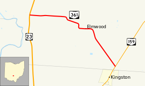
that bring the route further south. In the unincorporated community of
Elmwood, the road passes over a railroad via a bridge. After the railroad bridge, SR 361 curves to the southeast and passes through more farmland before ending at a skewed
308:. By 1934, the route received its number of SR 361. The route was extended to its current length between US 23 and SR 159 circa 1937. By 1948, the route was fully paved and has not changed since its first designation.
649:
430:
317:
244:
85:
612:
586:
560:
534:
508:
165:
454:
450:
53:
644:
175:
170:
359:
321:
256:
248:
140:
81:
387:
260:
215:
200:
100:
279:
US 23 in
Pickaway Township. The two-lane road travels east through farmland though there are two
421:
367:
363:
289:
180:
276:
300:
A segment of modern-day SR 361 running about 1.6 miles (2.6 km) from US 23 to the
285:
264:
638:
280:
240:
120:
486:
305:
516:(Map). Cartography by ODHPW. Ohio Department of Highways and Public Works. 1931
301:
39:
275:
The state highway begins at an unsignalized intersection with the
25:
429:
288:
with SR 159 about 0.2 miles (0.32 km) north of the
Pickaway-
252:
130:
304:
State
Memorial was first designated in 1932 as an unnumbered
396:
1.000 mi = 1.609 km; 1.000 km = 0.621 mi
417:
412:
150:
136:
126:
116:
111:
91:
72:
67:
59:
46:
21:
8:
455:"Technical Services Straight Line Diagrams"
431:Template:Attached KML/Ohio State Route 361
326:
239:) is a 4.67-mile-long (7.52 km) long
189:
16:State highway in Pickaway County, Ohio, US
434:
620:(Map). Cartography by ODHPW. ODHPW. 1948
594:(Map). Cartography by ODHPW. ODHPW. 1937
568:(Map). Cartography by ODHPW. ODHPW. 1934
542:(Map). Cartography by ODHPW. ODHPW. 1932
650:Transportation in Pickaway County, Ohio
439:
18:
445:
443:
381:
375:
353:
347:
7:
476:
474:
335:
292:line and the village of Kingston.
14:
451:Ohio Department of Transportation
614:Map of Ohio Showing State Routes
588:Map of Ohio Showing State Routes
562:Map of Ohio Showing State Routes
536:Map of Ohio Showing State Routes
510:Map of Ohio Showing State Routes
382:
354:
210:
195:
95:
76:
63:4.67 mi (7.52 km)
38:
24:
1:
330:
666:
395:
391:
378:
371:
350:
342:
339:
334:
329:
188:
159:Ohio State Highway System
155:
146:
107:
51:
37:
243:entirely located within
316:The entire route is in
645:State highways in Ohio
482:"Ohio State Route 361"
255:. The route connects
435:KML is from Wikidata
103:in Pickaway Township
312:Major intersections
401:
400:
318:Pickaway Township
271:Route description
245:Pickaway Township
226:
225:
222:
221:
86:Pickaway Township
47:Route information
657:
629:
628:
626:
625:
619:
609:
603:
602:
600:
599:
593:
583:
577:
576:
574:
573:
567:
557:
551:
550:
548:
547:
541:
531:
525:
524:
522:
521:
515:
505:
499:
498:
496:
494:
478:
469:
468:
466:
464:
459:
447:
425:
386:
385:
358:
357:
337:
332:
327:
218:
214:
213:
203:
199:
198:
190:
99:
98:
80:
79:
42:
28:
19:
665:
664:
660:
659:
658:
656:
655:
654:
635:
634:
633:
632:
623:
621:
617:
611:
610:
606:
597:
595:
591:
585:
584:
580:
571:
569:
565:
559:
558:
554:
545:
543:
539:
533:
532:
528:
519:
517:
513:
507:
506:
502:
492:
490:
480:
479:
472:
462:
460:
457:
449:
448:
441:
436:
433:
428:
427:
426:
410:
406:
397:
383:
355:
322:Pickaway County
314:
298:
273:
249:Pickaway County
229:State Route 361
211:
209:
196:
194:
96:
77:
68:Major junctions
33:
32:
31:State Route 361
29:
17:
12:
11:
5:
663:
661:
653:
652:
647:
637:
636:
631:
630:
604:
578:
552:
526:
500:
470:
438:
437:
409:
408:
407:
405:
402:
399:
398:
393:
392:
390:
380:
377:
373:
372:
370:
352:
349:
345:
344:
341:
338:
333:
313:
310:
297:
294:
286:T-intersection
272:
269:
263:just north of
224:
223:
220:
219:
206:
204:
186:
185:
184:
183:
178:
173:
168:
162:
161:
153:
152:
151:Highway system
148:
147:
144:
143:
138:
134:
133:
128:
124:
123:
118:
114:
113:
109:
108:
105:
104:
93:
89:
88:
74:
70:
69:
65:
64:
61:
57:
56:
52:Maintained by
49:
48:
44:
43:
35:
34:
30:
23:
22:
15:
13:
10:
9:
6:
4:
3:
2:
662:
651:
648:
646:
643:
642:
640:
616:
615:
608:
605:
590:
589:
582:
579:
564:
563:
556:
553:
538:
537:
530:
527:
512:
511:
504:
501:
489:
488:
483:
477:
475:
471:
456:
452:
446:
444:
440:
432:
423:
419:
415:
414:
403:
394:
389:
374:
369:
365:
361:
346:
328:
325:
323:
319:
311:
309:
307:
303:
295:
293:
291:
287:
282:
278:
270:
268:
266:
262:
258:
254:
250:
246:
242:
241:state highway
238:
234:
230:
217:
207:
205:
202:
192:
191:
187:
182:
179:
177:
174:
172:
169:
167:
164:
163:
160:
157:
156:
154:
149:
145:
142:
139:
135:
132:
129:
125:
122:
121:United States
119:
115:
110:
106:
102:
94:
92:East end
90:
87:
83:
75:
73:West end
71:
66:
62:
58:
55:
50:
45:
41:
36:
27:
20:
622:. Retrieved
613:
607:
596:. Retrieved
587:
581:
570:. Retrieved
561:
555:
544:. Retrieved
535:
529:
518:. Retrieved
509:
503:
491:. Retrieved
485:
461:. Retrieved
411:
340:Destinations
315:
299:
274:
236:
232:
228:
227:
158:
487:Google Maps
388:SR 159
368:Circleville
364:Chillicothe
306:gravel road
290:Ross County
216:SR 362
201:SR 360
101:SR 159
639:Categories
624:2013-09-28
598:2013-09-28
572:2013-09-28
546:2013-09-28
520:2013-09-28
493:October 4,
463:October 6,
404:References
360:US 23
166:Interstate
82:US 23
302:Logan Elm
413:KML file
362: –
281:S-curves
265:Kingston
141:Pickaway
137:Counties
112:Location
618:(MrSID)
592:(MrSID)
566:(MrSID)
540:(MrSID)
514:(MrSID)
484:(Map).
296:History
277:divided
117:Country
261:SR 159
237:OH 361
233:SR 361
181:Scenic
60:Length
458:(PDF)
343:Notes
259:with
257:US 23
176:State
127:State
495:2013
465:2013
422:help
418:edit
379:7.52
376:4.67
351:0.00
348:0.00
253:Ohio
131:Ohio
54:ODOT
84:in
641::
473:^
453:.
442:^
420:•
366:,
336:km
331:mi
324:.
320:,
267:.
251:,
247:,
235:,
208:→
193:←
171:US
627:.
601:.
575:.
549:.
523:.
497:.
467:.
424:)
416:(
231:(
Text is available under the Creative Commons Attribution-ShareAlike License. Additional terms may apply.