492:
121:
51:
37:
487:
449:
243:
228:
116:
428:
403:
97:
346:. In 1939, State Route 166 was re-routed. From the current junction of State Route 166 and State Route 528, State Route 166 was routed east, replacing what was formerly designated as State Route 522, to the intersection that marks State Route 166's current eastern terminus at
334:
The debut of State Route 166 took place in 1923. The original routing of State Route 166 consisted of the existing route of State Route 166 from its current western terminus northeast of
765:
760:
731:
474:
323:
307:
456:
415:
311:
681:
655:
592:
563:
390:
303:
196:
618:
536:
64:
755:
540:
627:
206:
201:
740:
354:. In turn, State Route 528 was extended northward, replacing what was the north-south leg of State Route 166.
469:
315:
171:
326:, a system of highways identified as most important for the economy, mobility and defense of the nation.
342:, and State Route 528 from that intersection north to that highway's current northern terminus north of
495:
452:
406:
347:
339:
319:
287:
246:
231:
124:
100:
431:
385:
279:
167:
722:
460:
211:
351:
291:
128:
17:
631:
749:
571:(Map). Cartography by ODHPW. Ohio Department of Highways and Public Works. April 1922
503:
343:
335:
283:
267:
147:
104:
600:(Map). Cartography by ODHPW. Ohio Department of Highways and Public Works. July 1923
499:
271:
278:. The western terminus of State Route 166 is at a T-intersection with
50:
314:, it curves to face the east. It then crosses the county line into
36:
730:
275:
157:
322:, near Rock Creek. No segment of this highway is a part of the
689:(Map). Cartography by ODOH. Ohio Department of Highways. 1940
663:(Map). Cartography by ODOH. Ohio Department of Highways. 1939
512:
1.000 mi = 1.609 km; 1.000 km = 0.621 mi
718:
713:
306:, traveling northeast through the northwest corner of
310:, passing by Curtis Airport. After it crosses into
181:
163:
153:
143:
138:
110:
91:
86:
78:
70:
57:
32:
498: / CR 12 (Footville-Richmond Road) –
587:
585:
558:
556:
282:just over 3 miles (4.8 km) northeast of
8:
541:"Technical Services Straight Line Diagrams"
732:Template:Attached KML/Ohio State Route 166
361:
220:
735:
766:Transportation in Ashtabula County, Ohio
525:
29:
27:State highway in northeastern Ohio, US
761:Transportation in Geauga County, Ohio
531:
529:
484:
478:
446:
440:
425:
419:
400:
394:
7:
290:about 5 miles (8.0 km) west of
270:in the northeastern portion of the
74:11.40 mi (18.35 km)
25:
537:Ohio Department of Transportation
594:Map of Ohio Showing State Routes
490:
485:
457:Thompson Township, Geauga County
447:
426:
401:
241:
226:
119:
114:
95:
49:
35:
741:State Route 166 Endpoint Photos
630:. December 2003. Archived from
628:Federal Highway Administration
286:. Its eastern terminus is at
1:
620:National Highway System: Ohio
18:Ohio State Route 522 (1930s)
782:
565:Map of Ohio State Highways
302:State Route 166 starts in
511:
507:
481:
473:
468:
464:
443:
436:
422:
414:
410:
397:
389:
384:
379:
376:
373:
370:
367:
364:
219:
190:Ohio State Highway System
186:
177:
134:
62:
48:
266:) is an east–west
324:National Highway System
756:State highways in Ohio
455:(Madison Road) –
338:to its junction with
736:KML is from Wikidata
637:on October 16, 2008
358:Major intersections
127: / CR 12 near
308:Montville Township
517:
516:
475:Trumbull Township
416:Thompson Township
312:Thompson Township
298:Route description
257:
256:
253:
252:
58:Route information
16:(Redirected from
773:
726:
698:
697:
695:
694:
688:
683:Ohio Highway Map
678:
672:
671:
669:
668:
662:
657:Ohio Highway Map
652:
646:
645:
643:
642:
636:
625:
615:
609:
608:
606:
605:
599:
589:
580:
579:
577:
576:
570:
560:
551:
550:
548:
547:
533:
494:
493:
489:
488:
451:
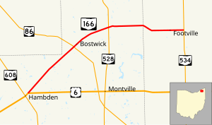
450:
430:
429:
405:
404:
391:Hambden Township
362:
316:Ashtabula County
249:
245:
244:
234:
230:
229:
221:
123:
122:
118:
117:
99:
98:
53:
39:
30:
21:
781:
780:
776:
775:
774:
772:
771:
770:
746:
745:
737:
734:
729:
728:
727:
711:
707:
702:
701:
692:
690:
686:
680:
679:
675:
666:
664:
660:
654:
653:
649:
640:
638:
634:
623:
617:
616:
612:
603:
601:
597:
591:
590:
583:
574:
572:
568:
562:
561:
554:
545:
543:
535:
534:
527:
522:
513:
491:
486:
448:
427:
402:
360:
348:State Route 534
340:State Route 528
332:
300:
288:State Route 534
260:State Route 166
242:
240:
227:
225:
120:
115:
96:
87:Major junctions
44:
43:
42:State Route 166
40:
28:
23:
22:
15:
12:
11:
5:
779:
777:
769:
768:
763:
758:
748:
747:
744:
743:
710:
709:
708:
706:
705:External links
703:
700:
699:
673:
647:
610:
581:
552:
524:
523:
521:
518:
515:
514:
509:
508:
506:
483:
480:
477:
472:
466:
465:
463:
445:
442:
438:
437:
435:
424:
421:
418:
412:
411:
409:
399:
396:
393:
388:
382:
381:
378:
375:
372:
369:
366:
359:
356:
331:
328:
299:
296:
255:
254:
251:
250:
237:
235:
217:
216:
215:
214:
209:
204:
199:
193:
192:
184:
183:
182:Highway system
179:
178:
175:
174:
165:
161:
160:
155:
151:
150:
145:
141:
140:
136:
135:
132:
131:
112:
108:
107:
93:
89:
88:
84:
83:
80:
76:
75:
72:
68:
67:
63:Maintained by
60:
59:
55:
54:
46:
45:
41:
34:
33:
26:
24:
14:
13:
10:
9:
6:
4:
3:
2:
778:
767:
764:
762:
759:
757:
754:
753:
751:
742:
739:
738:
733:
724:
720:
716:
715:
704:
685:
684:
677:
674:
659:
658:
651:
648:
633:
629:
622:
621:
614:
611:
596:
595:
588:
586:
582:
567:
566:
559:
557:
553:
542:
538:
532:
530:
526:
519:
510:
505:
501:
497:
476:
471:
467:
462:
458:
454:
439:
433:
417:
413:
408:
392:
387:
383:
363:
357:
355:
353:
349:
345:
341:
337:
329:
327:
325:
321:
317:
313:
309:
305:
297:
295:
293:
289:
285:
281:
277:
273:
269:
268:state highway
265:
261:
248:
238:
236:
233:
223:
222:
218:
213:
210:
208:
205:
203:
200:
198:
195:
194:
191:
188:
187:
185:
180:
176:
173:
169:
166:
162:
159:
156:
152:
149:
148:United States
146:
142:
137:
133:
130:
126:
113:
111:East end
109:
106:
102:
94:
92:West end
90:
85:
81:
77:
73:
69:
66:
61:
56:
52:
47:
38:
31:
19:
712:
691:. Retrieved
682:
676:
665:. Retrieved
656:
650:
639:. Retrieved
632:the original
619:
613:
602:. Retrieved
593:
573:. Retrieved
564:
544:. Retrieved
434:(Plank Road)
377:Destinations
333:
318:, ending at
301:
280:U.S. Route 6
263:
259:
258:
189:
82:1923–present
496:SR 534
461:Middlefield
453:SR 528
247:SR 167
232:SR 165
125:SR 534
750:Categories
693:2011-01-08
667:2011-01-08
641:2011-01-08
604:2011-01-08
575:2011-01-08
546:2006-11-12
520:References
432:SR 86
352:Rock Creek
292:Rock Creek
272:U.S. state
197:Interstate
129:Rock Creek
470:Ashtabula
407:US 6
172:Ashtabula
101:US 6
714:KML file
368:Location
350:west of
164:Counties
139:Location
687:(MrSID)
661:(MrSID)
626:(Map).
598:(MrSID)
569:(MrSID)
504:Windsor
344:Madison
336:Chardon
330:History
304:Hambden
284:Chardon
144:Country
105:Chardon
79:Existed
500:Geneva
386:Geauga
365:County
320:SR 534
264:SR 166
212:Scenic
168:Geauga
71:Length
635:(PDF)
624:(PDF)
482:18.35
479:11.40
444:10.61
380:Notes
207:State
154:State
103:near
723:help
719:edit
441:6.59
423:6.58
420:4.09
398:0.00
395:0.00
276:Ohio
158:Ohio
65:ODOT
274:of
752::
721:•
584:^
555:^
539:.
528:^
502:,
459:,
374:km
371:mi
294:.
239:→
224:←
202:US
170:,
725:)
717:(
696:.
670:.
644:.
607:.
578:.
549:.
262:(
20:)
Text is available under the Creative Commons Attribution-ShareAlike License. Additional terms may apply.