288:
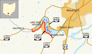
northeast. Generally following in parallel with the south shore of Lake White, the state highway passes a number of cottages and side streets that connect to additional cottages. The highway then travels in an inverted "U", curving east and then to the south and southeast. SR 551 turns east just prior to the park lands of Lake White State Park and its endpoint at a T-intersection with SR 104.
40:
26:
367:
347:
220:
205:
105:
86:
287:
SR 551 commences at a T-intersection with SR 220 near the west shore of Lake White southwest of the village of
Waverly. Abutted by forest on the south side for most of its length, SR 551 starts out in a southerly direction, then hooks around the west end of Lake White, bending to the
462:
303:
Originally designated in 1937 along the route that it currently occupies along the south shore of Lake White, SR 551 has not seen any significant changes to its routing since its creation.
600:
413:
292:
498:
312:
268:
173:
520:
561:
440:
53:
595:
433:
529:
489:
183:
178:
276:
370:
350:
272:
260:
252:
223:
208:
108:
89:
263:
approximately two and a half miles (4.0 km) southwest of
Waverly. Existing entirely within
404:
316:
264:
188:
148:
533:
589:
256:
244:
128:
93:
467:
39:
25:
412:
248:
138:
379:
1.000 mi = 1.609 km; 1.000 km = 0.621 mi
271:, SR 551 follows the south shore of Lake White, while
400:
395:
259:, and its eastern terminus is at a T-intersection with
251:. Its western terminus is at a T-intersection with
158:
144:
134:
124:
119:
99:
80:
75:
67:
59:
46:
21:
279:is located near SR 551's western terminus.
578:(Map). Ohio Department of Transportation. 1937.
291:No part of SR 551 is included within the
8:
255:about four miles (6.4 km) southwest of
414:Template:Attached KML/Ohio State Route 551
321:
197:
428:
426:
417:
422:
18:
16:State highway in Pike County, Ohio, US
364:
358:
344:
338:
7:
499:Ohio Department of Natural Resources
601:Transportation in Pike County, Ohio
14:
562:Ohio Department of Transportation
463:"Overview Map of State Route 551"
441:Ohio Department of Transportation
365:
345:
218:
203:
103:
84:
63:2.87 mi (4.62 km)
38:
24:
532:. December 2003. Archived from
530:Federal Highway Administration
1:
522:National Highway System: Ohio
617:
378:
374:
361:
354:
341:
333:
330:
327:
324:
275:follows the north shore.
196:
167:Ohio State Highway System
163:
154:
115:
51:
37:
434:"DESTAPE - Pike County"
311:The entire route is in
293:National Highway System
596:State highways in Ohio
491:Lake White State Park
277:Lake White State Park
418:KML is from Wikidata
539:on October 16, 2008
307:Major intersections
243:) is an east-west
384:
383:
283:Route description
234:
233:
230:
229:
47:Route information
608:
580:
579:
572:
566:
565:
554:
548:
547:
545:
544:
538:
527:
517:
511:
510:
508:
506:
496:
486:
480:
479:
477:
475:
459:
453:
452:
450:
448:
438:
430:
408:
369:
368:
349:
348:
322:
313:Pee Pee Township
269:Pee Pee Township
226:
222:
221:
211:
207:
206:
198:
107:
106:
88:
87:
42:
28:
19:
616:
615:
611:
610:
609:
607:
606:
605:
586:
585:
584:
583:
574:
573:
569:
556:
555:
551:
542:
540:
536:
525:
519:
518:
514:
504:
502:
494:
488:
487:
483:
473:
471:
461:
460:
456:
446:
444:
443:. June 24, 2015
436:
432:
431:
424:
419:
416:
411:
410:
409:
393:
389:
380:
366:
346:
309:
301:
285:
237:State Route 551
219:
217:
204:
202:
104:
85:
76:Major junctions
33:
32:
31:State Route 551
29:
17:
12:
11:
5:
614:
612:
604:
603:
598:
588:
587:
582:
581:
576:Ohio State Map
567:
558:Ohio State Map
549:
512:
481:
454:
421:
420:
392:
391:
390:
388:
385:
382:
381:
376:
375:
373:
363:
360:
356:
355:
353:
343:
340:
336:
335:
332:
329:
326:
308:
305:
300:
297:
284:
281:
232:
231:
228:
227:
214:
212:
194:
193:
192:
191:
186:
181:
176:
170:
169:
161:
160:
159:Highway system
156:
155:
152:
151:
146:
142:
141:
136:
132:
131:
126:
122:
121:
117:
116:
113:
112:
101:
97:
96:
82:
78:
77:
73:
72:
69:
65:
64:
61:
57:
56:
52:Maintained by
49:
48:
44:
43:
35:
34:
30:
23:
22:
15:
13:
10:
9:
6:
4:
3:
2:
613:
602:
599:
597:
594:
593:
591:
577:
571:
568:
563:
559:
553:
550:
535:
531:
524:
523:
516:
513:
500:
493:
492:
485:
482:
470:
469:
464:
458:
455:
442:
435:
429:
427:
423:
415:
406:
402:
398:
397:
386:
377:
372:
357:
352:
337:
323:
320:
318:
314:
306:
304:
298:
296:
294:
289:
282:
280:
278:
274:
270:
266:
262:
258:
254:
250:
246:
245:state highway
242:
238:
225:
215:
213:
210:
200:
199:
195:
190:
187:
185:
182:
180:
177:
175:
172:
171:
168:
165:
164:
162:
157:
153:
150:
147:
143:
140:
137:
133:
130:
129:United States
127:
123:
118:
114:
110:
102:
100:East end
98:
95:
91:
83:
81:West end
79:
74:
70:
66:
62:
58:
55:
50:
45:
41:
36:
27:
20:
575:
570:
557:
552:
541:. Retrieved
534:the original
521:
515:
503:. Retrieved
490:
484:
472:. Retrieved
466:
457:
445:. Retrieved
394:
331:Destinations
310:
302:
290:
286:
247:in southern
240:
236:
235:
166:
111:near Waverly
71:1937–present
505:November 8,
501:. July 2011
474:November 8,
468:Google Maps
447:November 8,
371:SR 104
351:SR 220
317:Pike County
273:SR 552
265:Pike County
261:SR 104
253:SR 220
224:SR 552
209:SR 550
109:SR 104
90:SR 220
590:Categories
543:2010-04-23
387:References
174:Interstate
396:KML file
145:Counties
120:Location
564:. 1936.
560:(Map).
528:(Map).
497:(Map).
465:(Map).
299:History
257:Waverly
125:Country
94:Waverly
68:Existed
241:SR 551
189:Scenic
60:Length
537:(PDF)
526:(PDF)
495:(PDF)
437:(PDF)
334:Notes
184:State
135:State
92:near
507:2015
476:2015
449:2015
405:help
401:edit
362:4.62
359:2.87
342:0.00
339:0.00
249:Ohio
149:Pike
139:Ohio
54:ODOT
267:'s
592::
439:.
425:^
403:•
328:km
325:mi
319:.
315:,
295:.
216:→
201:←
179:US
546:.
509:.
478:.
451:.
407:)
399:(
239:(
Text is available under the Creative Commons Attribution-ShareAlike License. Additional terms may apply.