337:
468:
379:
554:
40:
26:
566:
463:
258:
243:
139:
94:
560:
498:
134:
524:
115:
414:
In 1941, SR 640 was designated along the path that it maintains to this day between
Willowick and Willoughby in western Lake County. SR 640 replaced the stretch of roadway that was designated as SR 288 prior to 1941. No changes of major significance have taken place to the route since its
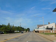
356:. The highway widens to four lanes when it crosses into Eastlake, and remains four lanes for the remainder of its length. The highway passes mostly chain retailers and apartment complexes along its length. It passes just north of
328:
and
Willoughby. Known as Vine Street for its entire length, this stretch of roadway carried the designation of SR 288 prior to being re-designated as SR 640 in the early 1940s.
750:
618:
368:
211:
665:
706:
642:
638:
53:
745:
674:
221:
216:
569:
475:
306:
142:
573:
471:
310:
294:
261:
246:
146:
97:
501:
361:
527:
118:
371:, a network of highways deemed most important for the country's economy, mobility and defense.
609:
535:
424:
345:
317:
226:
186:
511:
353:
302:
122:
678:
336:
450:
349:
298:
101:
485:
325:
378:
739:
282:
166:
357:
352:. Starting at the highway's western terminus, the highway is three lanes with a
286:
531:
321:
313:, the latter of which has its northern terminus at this same intersection.
293:. SR 640 has its western terminus is at a signalized intersection with
39:
335:
25:
617:
290:
176:
373:
584:
1.000 mi = 1.609 km; 1.000 km = 0.621 mi
605:
600:
390:
196:
182:
172:
162:
157:
128:
107:
88:
83:
75:
67:
59:
46:
21:
367:No portion of the highway is included within the
723:(Map). Ohio Department of Transportation. 1941.
8:
316:Located entirely within the western part of
305:at a signalized intersection where it meets
643:"Technical Services Straight Line Diagrams"
619:Template:Attached KML/Ohio State Route 640
429:
235:
622:
627:
301:. Its eastern terminus is in downtown
18:
16:State highway in Lake County, Ohio, US
633:
631:
550:
544:
521:
515:
495:
489:
460:
454:
7:
344:SR 640 runs entirely within western
79:1931–1940 (as State Route 288)
751:Transportation in Lake County, Ohio
340:SR 640 westbound in Willoughby
285:in the northeastern portion of the
14:
707:Ohio Department of Transportation
639:Ohio Department of Transportation
320:, SR 640 serves the northeastern
564:
558:
552:
522:
496:
466:
461:
377:
256:
241:
137:
132:
113:
92:
63:3.35 mi (5.39 km)
38:
24:
677:. December 2003. Archived from
348:in the northeastern suburbs of
675:Federal Highway Administration
1:
667:National Highway System: Ohio
576:(Mentor Avenue / Erie Street)
579:Northern terminus of SR 174
360:near the intersection with
767:
583:
578:
547:
539:
518:
510:
506:
492:
484:
480:
457:
449:
444:
441:
438:
435:
432:
297:(Lakeshore Boulevard) in
234:
205:Ohio State Highway System
201:
192:
153:
51:
37:
281:) is an east–west
423:The entire route is in
369:National Highway System
746:State highways in Ohio
478:(Lake Shore Boulevard)
364:(S.O.M. Center Road).
341:
324:suburbs of Willowick,
339:
623:KML is from Wikidata
684:on October 16, 2008
419:Major intersections
109:Major intersections
389:. You can help by
342:
589:
588:
504:(Som Center Road)
407:
406:
332:Route description
272:
271:
268:
267:
47:Route information
758:
725:
724:
717:
711:
710:
699:
693:
692:
690:
689:
683:
672:
662:
656:
655:
653:
652:
647:
635:
613:
568:
567:
563:
562:
561:
556:
555:
526:
525:
500:
499:
470:
469:
465:
464:
430:
402:
399:
381:
374:
354:center turn lane
264:
260:
259:
249:
245:
244:
236:
141:
140:
136:
135:
117:
116:
110:
96:
95:
42:
28:
19:
766:
765:
761:
760:
759:
757:
756:
755:
736:
735:
734:
729:
728:
719:
718:
714:
701:
700:
696:
687:
685:
681:
670:
664:
663:
659:
650:
648:
645:
637:
636:
629:
624:
621:
616:
615:
614:
598:
594:
585:
565:
559:
557:
553:
551:
523:
497:
467:
462:
421:
412:
403:
397:
394:
387:needs expansion
334:
275:State Route 640
257:
255:
242:
240:
138:
133:
114:
108:
93:
84:Major junctions
33:
32:
31:State Route 640
29:
17:
12:
11:
5:
764:
762:
754:
753:
748:
738:
737:
733:
732:External links
730:
727:
726:
721:Ohio State Map
712:
703:Ohio State Map
694:
657:
626:
625:
597:
596:
595:
593:
590:
587:
586:
581:
580:
577:
549:
546:
542:
541:
538:
520:
517:
514:
508:
507:
505:
494:
491:
488:
482:
481:
479:
459:
456:
453:
447:
446:
443:
440:
437:
434:
420:
417:
411:
408:
405:
404:
384:
382:
333:
330:
270:
269:
266:
265:
252:
250:
232:
231:
230:
229:
224:
219:
214:
208:
207:
199:
198:
197:Highway system
194:
193:
190:
189:
184:
180:
179:
174:
170:
169:
164:
160:
159:
155:
154:
151:
150:
130:
126:
125:
111:
105:
104:
90:
86:
85:
81:
80:
77:
73:
72:
69:
65:
64:
61:
57:
56:
52:Maintained by
49:
48:
44:
43:
35:
34:
30:
23:
22:
15:
13:
10:
9:
6:
4:
3:
2:
763:
752:
749:
747:
744:
743:
741:
731:
722:
716:
713:
708:
704:
698:
695:
680:
676:
669:
668:
661:
658:
644:
640:
634:
632:
628:
620:
611:
607:
603:
602:
591:
582:
575:
572:south /
571:
543:
537:
533:
529:
513:
509:
503:
487:
483:
477:
473:
452:
448:
431:
428:
426:
418:
416:
409:
401:
392:
388:
385:This section
383:
380:
376:
375:
372:
370:
365:
363:
359:
355:
351:
347:
338:
331:
329:
327:
323:
319:
314:
312:
308:
304:
300:
296:
292:
288:
284:
283:state highway
280:
276:
263:
253:
251:
248:
238:
237:
233:
228:
225:
223:
220:
218:
215:
213:
210:
209:
206:
203:
202:
200:
195:
191:
188:
185:
181:
178:
175:
171:
168:
167:United States
165:
161:
156:
152:
149:in Willoughby
148:
144:
131:
129:East end
127:
124:
120:
112:
106:
103:
99:
91:
89:West end
87:
82:
78:
74:
70:
66:
62:
58:
55:
50:
45:
41:
36:
27:
20:
720:
715:
702:
697:
686:. Retrieved
679:the original
666:
660:
649:. Retrieved
599:
442:Destinations
422:
413:
398:January 2011
395:
391:adding to it
386:
366:
358:Classic Park
343:
315:
278:
274:
273:
204:
71:1941–present
574:SR 174
540:Interchange
536:Painesville
472:SR 283
425:Lake County
415:inception.
346:Lake County
318:Lake County
262:SR 643
247:SR 638
147:SR 174
98:SR 283
740:Categories
688:2011-01-01
651:2013-07-11
592:References
570:US 20
512:Willoughby
502:SR 91
303:Willoughby
287:U.S. state
212:Interstate
143:US 20
123:Willoughby
532:Cleveland
528:SR 2
451:Willowick
350:Cleveland
322:Cleveland
299:Willowick
119:SR 2
102:Willowick
601:KML file
530: –
486:Eastlake
474: /
433:Location
326:Eastlake
183:Counties
158:Location
145: /
54:O.D.O.T.
709:. 1940.
705:(Map).
673:(Map).
410:History
163:Country
76:History
68:Existed
311:SR 174
295:SR 283
279:SR 640
227:Scenic
60:Length
682:(PDF)
671:(PDF)
646:(PDF)
445:Notes
362:SR 91
307:US 20
222:State
173:State
610:help
606:edit
548:5.39
545:3.35
519:3.78
516:2.35
493:2.80
490:1.74
476:LECT
458:0.00
455:0.00
309:and
291:Ohio
187:Lake
177:Ohio
393:.
289:of
121:in
100:in
742::
641:.
630:^
608:•
534:,
439:km
436:mi
427:.
254:→
239:←
217:US
691:.
654:.
612:)
604:(
400:)
396:(
277:(
Text is available under the Creative Commons Attribution-ShareAlike License. Additional terms may apply.