323:
40:
482:
469:
439:
26:
488:
407:
236:
221:
110:
86:
475:
445:
105:
358:
State Route 697 was established in 1938 along the routing that it utilizes to this day. No changes of major significance have taken place to the highway throughout its history.
681:
686:
557:
312:
394:
189:
601:
642:
577:
53:
676:
581:
610:
199:
194:
389:
304:
160:
496:
410:
292:
276:
239:
224:
117:
89:
492:
449:
288:
113:
517:
420:
308:
280:
164:
93:
548:
204:
614:
322:
670:
425:
284:
264:
140:
121:
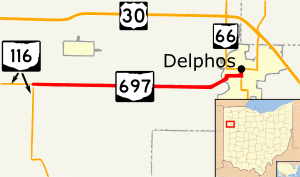
283:. The eastern terminus of this route is located on the northern fringe of downtown
272:
275:. The western terminus of State Route 697 is located at its junction with
39:
291:
at a signalized intersection that doubles as the southern terminus of
465:
435:
25:
556:
287:, following a nearly 0.25 miles (0.40 km) concurrency with
268:
150:
502:
Northern end of SR 66 concurrency; southern terminus of SR 190
317:
507:
1.000 mi = 1.609 km; 1.000 km = 0.621 mi
544:
539:
334:
303:
This state highway runs through the eastern portion of
501:
454:
452:
south (South Main Street) / East Second Street
174:
156:
146:
136:
131:
99:
80:
75:
67:
59:
46:
21:
279:approximately 2 miles (3.2 km) southwest of
659:(Map). Ohio Department of Transportation. 1938.
307:, and into the extreme northwestern corner of
499:north (Fifth Street) / North Main Street
8:
582:"Technical Services Straight Line Diagrams"
558:Template:Attached KML/Ohio State Route 697
365:
213:
561:
311:. State Route 697 is not a part of the
682:Transportation in Van Wert County, Ohio
566:
455:Southern end of SR 66 concurrency
18:
572:
570:
459:
429:
404:
398:
7:
687:Transportation in Allen County, Ohio
14:
643:Ohio Department of Transportation
578:Ohio Department of Transportation
63:7.54 mi (12.13 km)
16:State highway in western Ohio, US
486:
480:
473:
467:
443:
437:
405:
321:
234:
219:
108:
103:
84:
38:
24:
613:. December 2003. Archived from
611:Federal Highway Administration
1:
603:National Highway System: Ohio
703:
267:in the western portion of
506:
462:
432:
424:
419:
415:
401:
393:
388:
383:
380:
377:
374:
371:
368:
212:
183:Ohio State Highway System
179:
170:
127:
51:
37:
513:
263:) is an east–west
313:National Highway System
677:State highways in Ohio
413: / Ringwald Road
562:KML is from Wikidata
620:on October 16, 2008
362:Major intersections
333:. You can help by
528:
527:
351:
350:
299:Route description
250:
249:
246:
245:
47:Route information
694:
661:
660:
653:
647:
646:
635:
629:
628:
626:
625:
619:
608:
598:
592:
591:
589:
588:
574:
552:
521:
514:
491:
490:
489:
484:
483:
478:
477:
476:
471:
470:
448:
447:
446:
441:
440:
409:
408:
366:
346:
343:
325:
318:
242:
238:
237:
227:
223:
222:
214:
112:
111:
107:
106:
88:
87:
42:
28:
19:
702:
701:
697:
696:
695:
693:
692:
691:
667:
666:
665:
664:
655:
654:
650:
637:
636:
632:
623:
621:
617:
606:
600:
599:
595:
586:
584:
576:
575:
568:
563:
560:
555:
554:
553:
537:
533:
524:
516:
512:
508:
487:
485:
481:
479:
474:
472:
468:
466:
444:
442:
438:
436:
406:
364:
356:
347:
341:
338:
331:needs expansion
305:Van Wert County
301:
293:State Route 190
277:State Route 116
253:State Route 697
235:
233:
220:
218:
109:
104:
85:
76:Major junctions
33:
32:
31:State Route 697
29:
17:
12:
11:
5:
700:
698:
690:
689:
684:
679:
669:
668:
663:
662:
657:Ohio State Map
648:
639:Ohio State Map
630:
593:
565:
564:
536:
535:
534:
532:
529:
526:
525:
523:
522:
509:
504:
503:
500:
464:
461:
457:
456:
453:
434:
431:
428:
423:
417:
416:
414:
403:
400:
397:
395:Ridge Township
392:
386:
385:
382:
379:
376:
373:
370:
363:
360:
355:
352:
349:
348:
328:
326:
300:
297:
289:State Route 66
248:
247:
244:
243:
230:
228:
210:
209:
208:
207:
202:
197:
192:
186:
185:
177:
176:
175:Highway system
172:
171:
168:
167:
158:
154:
153:
148:
144:
143:
138:
134:
133:
129:
128:
125:
124:
101:
97:
96:
82:
78:
77:
73:
72:
69:
65:
64:
61:
57:
56:
52:Maintained by
49:
48:
44:
43:
35:
34:
30:
23:
22:
15:
13:
10:
9:
6:
4:
3:
2:
699:
688:
685:
683:
680:
678:
675:
674:
672:
658:
652:
649:
644:
640:
634:
631:
616:
612:
605:
604:
597:
594:
583:
579:
573:
571:
567:
559:
550:
546:
542:
541:
530:
519:
511:
510:
505:
498:
495:north /
494:
458:
451:
427:
422:
418:
412:
396:
391:
387:
367:
361:
359:
353:
345:
342:December 2010
336:
332:
329:This section
327:
324:
320:
319:
316:
314:
310:
306:
298:
296:
294:
290:
286:
282:
278:
274:
270:
266:
265:state highway
262:
258:
254:
241:
231:
229:
226:
216:
215:
211:
206:
203:
201:
198:
196:
193:
191:
188:
187:
184:
181:
180:
178:
173:
169:
166:
162:
159:
155:
152:
149:
145:
142:
141:United States
139:
135:
130:
126:
123:
119:
115:
102:
100:East end
98:
95:
91:
83:
81:West end
79:
74:
70:
66:
62:
58:
55:
50:
45:
41:
36:
27:
20:
656:
651:
638:
633:
622:. Retrieved
615:the original
602:
596:
585:. Retrieved
538:
515:
381:Destinations
357:
339:
335:adding to it
330:
309:Allen County
302:
281:Middle Point
260:
256:
252:
251:
182:
94:Middle Point
71:1938–present
518:Concurrency
497:SR 190
411:SR 116
240:SR 698
225:SR 696
118:SR 190
90:SR 116
671:Categories
624:2010-09-03
587:2010-09-03
531:References
493:SR 66
450:SR 66
273:U.S. state
190:Interstate
114:SR 66
540:KML file
520:terminus
390:Van Wert
372:Location
161:Van Wert
157:Counties
132:Location
116: /
645:. 1937.
641:(Map).
609:(Map).
426:Delphos
354:History
285:Delphos
137:Country
122:Delphos
68:Existed
369:County
261:OH 697
257:SR 697
205:Scenic
60:Length
618:(PDF)
607:(PDF)
463:12.13
433:11.76
421:Allen
384:Notes
200:State
165:Allen
147:State
92:near
549:help
545:edit
460:7.54
430:7.31
402:0.00
399:0.00
271:, a
269:Ohio
151:Ohio
54:ODOT
337:.
120:in
673::
580:.
569:^
547:•
378:km
375:mi
315:.
295:.
259:,
232:→
217:←
195:US
163:,
627:.
590:.
551:)
543:(
344:)
340:(
255:(
Text is available under the Creative Commons Attribution-ShareAlike License. Additional terms may apply.