426:
421:
110:
105:
296:
40:
26:
388:
225:
210:
86:
321:
1.25 miles (2.01 km) northeast of
Freeport. From this point, passing first amidst some open fields before entering into a more forested terrain, with the occasional house appearing along the way, SR 799 roughly parallels the Clendening Lake shoreline about one-quarter mile (0.40 km) to
330:
before turning north, re-entering
Nottingham Township, and then following Clendening Lake's eastern edge. SR 799 crosses small bays formed by the lake twice, and comes to an end at its intersection with CR 60 (Redeye Road) just past the lake's northernmost extent. The road continues
339:
SR 799 was designated in 1949. The highway has been a spur route since its inception, following the same alignment through the
Clendening Lake vicinity from that point to this very day. It has not experienced any major changes to its routing since it was established.
686:
608:
659:
408:
375:
327:
323:
318:
311:
521:
492:
268:
to its eastern terminus at its intersection with Redeye Road (County Road 60 or CR 60) about three miles (4.8 km) south of
178:
571:
551:
467:
53:
676:
460:
681:
580:
188:
183:
349:
307:
153:
547:
391:
261:
228:
213:
89:
650:
287:
of
Deersville. SR 799 is designated as a part of the Tappan-Moravian Trail Scenic Byway.
193:
269:
114:
584:
299:
280:
399:
395:
272:. Continuing north from SR 799's eastern terminus is Mallarnee Road (CR 21).
265:
93:
331:
another three miles (4.8 km) north to
Deersville as CR 21 (Mallarnee Road).
670:
249:
133:
613:
295:
276:
253:
283:
region. In addition, it provides an improved route from SR 800 to the
284:
260:. The highway runs from its western terminus at a T-intersection with
39:
294:
25:
658:
257:
143:
306:
This state highway exists entirely within the western part of
529:(Map). Cartography by ODOH. Ohio Department of Highways. 1949
500:(Map). Cartography by ODOH. Ohio Department of Highways. 1948
436:
1.000 mi = 1.609 km; 1.000 km = 0.621 mi
317:
SR 799 begins at a T-intersection with SR 800 in
275:
SR 799 was created in the late 1940s. This two-lane
646:
641:
264:
approximately 1.25 miles (2.01 km) northeast of
163:
149:
139:
129:
124:
99:
80:
75:
67:
59:
46:
21:
429:CR 21 (Mallarnee Road) / CR 60 (Redeye Road)
516:
514:
487:
485:
8:
660:Template:Attached KML/Ohio State Route 799
354:
202:
16:State highway in Harrison County, Ohio, US
663:
455:
453:
279:was established to improve access to the
687:Transportation in Harrison County, Ohio
449:
252:located in the eastern portion of the
18:
418:
412:
385:
379:
7:
548:"Tappan-Moravian Trail Scenic Byway"
322:the south, in the process entering
310:. SR 799 is not a part of the
14:
552:Ohio Department of Transportation
468:Ohio Department of Transportation
424:
419:
386:
223:
208:
108:
103:
84:
63:6.05 mi (9.74 km)
38:
24:
583:. December 2003. Archived from
581:Federal Highway Administration
1:
573:National Highway System: Ohio
461:"DESTAPE - Harrison County"
703:
435:
431:
415:
407:
403:
382:
374:
369:
366:
363:
360:
357:
201:
172:Ohio State Highway System
168:
159:
120:
51:
37:
248:) is an east–west
113:CR 21 / CR 60 near
348:The entire route is in
326:, dipping briefly into
312:National Highway System
677:State highways in Ohio
609:"Ohio State Route 799"
303:
682:Scenic byways in Ohio
298:
664:KML is from Wikidata
590:on October 16, 2008
409:Nottingham Township
376:Washington Township
344:Major intersections
328:Moorefield Township
324:Nottingham Township
319:Washington Township
304:
441:
440:
291:Route description
239:
238:
235:
234:
47:Route information
694:
654:
626:
625:
623:
621:
605:
599:
598:
596:
595:
589:
578:
568:
562:
561:
559:
558:
544:
538:
537:
535:
534:
528:
523:Ohio Highway Map
518:
509:
508:
506:
505:
499:
494:Ohio Highway Map
489:
480:
479:
477:
475:
465:
457:
428:
427:
423:
422:
390:
389:
355:
231:
227:
226:
216:
212:
211:
203:
112:
111:
107:
106:
88:
87:
42:
28:
19:
702:
701:
697:
696:
695:
693:
692:
691:
667:
666:
665:
662:
657:
656:
655:
639:
635:
630:
629:
619:
617:
607:
606:
602:
593:
591:
587:
576:
570:
569:
565:
556:
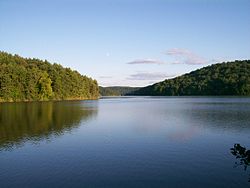
554:
546:
545:
541:
532:
530:
526:
520:
519:
512:
503:
501:
497:
491:
490:
483:
473:
471:
470:. June 24, 2015
463:
459:
458:
451:
446:
437:
425:
420:
387:
350:Harrison County
346:
337:
308:Harrison County
300:Clendening Lake
293:
281:Clendening Lake
242:State Route 799
224:
222:
209:
207:
109:
104:
85:
76:Major junctions
33:
32:
31:State Route 799
29:
17:
12:
11:
5:
700:
698:
690:
689:
684:
679:
669:
668:
638:
637:
636:
634:
633:External links
631:
628:
627:
600:
563:
539:
510:
481:
448:
447:
445:
442:
439:
438:
433:
432:
430:
417:
414:
411:
405:
404:
402:
384:
381:
378:
372:
371:
368:
365:
362:
359:
345:
342:
336:
333:
292:
289:
237:
236:
233:
232:
219:
217:
199:
198:
197:
196:
191:
186:
181:
175:
174:
166:
165:
164:Highway system
161:
160:
157:
156:
151:
147:
146:
141:
137:
136:
131:
127:
126:
122:
121:
118:
117:
101:
97:
96:
82:
78:
77:
73:
72:
69:
65:
64:
61:
57:
56:
52:Maintained by
49:
48:
44:
43:
35:
34:
30:
23:
22:
15:
13:
10:
9:
6:
4:
3:
2:
699:
688:
685:
683:
680:
678:
675:
674:
672:
661:
652:
648:
644:
643:
632:
616:
615:
610:
604:
601:
586:
582:
575:
574:
567:
564:
553:
549:
543:
540:
525:
524:
517:
515:
511:
496:
495:
488:
486:
482:
469:
462:
456:
454:
450:
443:
434:
410:
406:
401:
397:
393:
377:
373:
356:
353:
351:
343:
341:
334:
332:
329:
325:
320:
315:
313:
309:
301:
297:
290:
288:
286:
282:
278:
273:
271:
267:
263:
259:
255:
251:
250:state highway
247:
243:
230:
220:
218:
215:
205:
204:
200:
195:
192:
190:
187:
185:
182:
180:
177:
176:
173:
170:
169:
167:
162:
158:
155:
152:
148:
145:
142:
138:
135:
134:United States
132:
128:
123:
119:
116:
102:
100:East end
98:
95:
91:
83:
81:West end
79:
74:
70:
66:
62:
58:
55:
50:
45:
41:
36:
27:
20:
640:
618:. Retrieved
612:
603:
592:. Retrieved
585:the original
572:
566:
555:. Retrieved
542:
531:. Retrieved
522:
502:. Retrieved
493:
472:. Retrieved
367:Destinations
347:
338:
316:
305:
274:
245:
241:
240:
171:
71:1949–present
620:November 6,
614:Google Maps
474:November 6,
392:SR 800
302:from SR 799
262:SR 800
229:SR 800
214:SR 798
90:SR 800
671:Categories
594:2011-01-16
557:2008-10-09
533:2011-01-16
504:2011-01-16
444:References
277:spur route
270:Deersville
254:U.S. state
179:Interstate
115:Deersville
642:KML file
400:Dennison
396:Freeport
394: –
358:Location
266:Freeport
154:Harrison
150:Counties
125:Location
94:Freeport
611:(Map).
579:(Map).
527:(MrSID)
498:(MrSID)
335:History
285:village
130:Country
68:Existed
246:SR 799
194:Scenic
60:Length
588:(PDF)
577:(PDF)
464:(PDF)
370:Notes
189:State
140:State
92:near
651:help
647:edit
622:2015
476:2015
416:9.74
413:6.05
383:0.00
380:0.00
258:Ohio
144:Ohio
54:ODOT
256:of
673::
649:•
550:.
513:^
484:^
466:.
452:^
398:,
364:km
361:mi
352:.
314:.
221:→
206:←
184:US
653:)
645:(
624:.
597:.
560:.
536:.
507:.
478:.
244:(
Text is available under the Creative Commons Attribution-ShareAlike License. Additional terms may apply.