535:
46:
1260:
55:
1272:
549:
from the west near
Oroville. It receives Omak Creek from the east near Omak, Tonasket Creek from the east near Oroville and Bonaparte Creek at Tonasket which flows from Bonaparte Lake near Wauconda and also from
1004:
1317:
1312:
1307:
996:
979:
947:
739:
1302:
1009:
923:
653:
1204:
648:
867:
1275:
631:, via the river. After hostilities subsided, the route continued to be important as the southern leg of the overland trail to the
1086:
817:
476:
249:
1297:
972:
883:
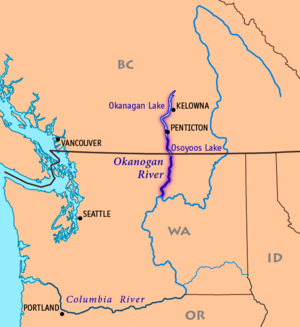
558:. It occasionally receives water from Salmon Creek at the town of Okanogan but much of the year this water is diverted for
1117:
164:
1229:
1025:
507:
484:
1239:
1234:
658:
534:
582:
era show the
Okanagan River as the "Caledonia River", a name conferred as it was the connecting route between the
1263:
1224:
965:
1244:
1132:
464:
820:
Annual Report to the
International Joint Commission from the International Osoyoos Lake Board of Control, 2004
702:
784:
768:
620:
613:
578:) placename . The name Okanagan was subsequently applied to the Syilx people themselves. Early maps of the
587:
623:
of 1858–1859, parties of armed miners, often at conflict with native peoples in the region, traveled the
952:
802:
492:
628:
743:
1127:
511:
499:
491:) changes spelling from Okanagan to Okanogan. Average annual flow of the river at this point is 643
480:
227:
1209:
1107:
1091:
597:
551:
45:
1178:
609:
412:
324:
231:
87:
919:
913:
863:
632:
583:
571:
546:
488:
432:
383:
1122:
988:
539:
519:
503:
420:
408:
146:
111:
97:
27:
River in North
America, through southern British Columbia and north central Washington state
510:. The Okanogan River enters the Columbia River from the north, 5 miles (8 km) east of
853:
689:
443:
The
Okanagan River rises in southern British Columbia, issuing out of the southern end of
1070:
909:
624:
522:(upstream). The reservoir behind Wells Dam, into which the Okanogan empties, is called
456:
404:
215:
1291:
1148:
1112:
828:
797:
636:
616:
in 1821, the latter company maintaining a presence at Fort
Okanogan until the 1850s.
593:
555:
444:
424:
235:
130:
77:
1219:
1188:
1183:
714:
676:
523:
472:
887:
857:
605:
460:
210:
498:
From
Oroville the Okanogan River flows south through the Okanogan County, past
780:
764:
601:
559:
452:
17:
264:
251:
179:
166:
1040:
1035:
726:
579:
515:
448:
142:
107:
54:
679:
coordinates for river's exit from
Okanagan Lake. Retrieved April 27, 2007.
608:
forced the PFC to sell its property and assets to its
Canadian rivals, the
703:
U.S. Geological Survey
Geographic Names Information System: Okanagan River
487:. At the border the river's name (and the region and also the name of the
428:
468:
431:
region of British Columbia. The Canadian portion of the river has been
416:
1214:
400:
150:
73:
957:
575:
533:
717:
elevation for mouth of Okanagan River. Retrieved April 27, 2007.
1173:
1168:
1163:
1158:
1153:
961:
604:
with the Columbia. The isolation and pressures caused by the
941:
407:, approximately 115 mi (185 km) long, in southern
59:
Map of the Okanogan River, tributary of the Columbia River
953:
Okanogan River height and discharge flow near Tonasket
1197:
1141:
1100:
1079:
1063:
1049:
1018:
995:
377:
369:
364:
350:
340:
330:
318:
310:
298:
290:
280:
241:
221:
209:
195:
156:
136:
126:
117:
103:
93:
83:
69:
64:
34:
427:and north and west of the Columbia, and also the
729:, The Columbia Gazetteer of North America. 2000.
915:Native American Placenames of the United States
600:(PFC) late in 1811, was located at the river's
862:. University of Washington Press. p. 25.
479:and has its outlet into the Okanogan River at
973:
918:. University of Oklahoma Press. p. 346.
8:
690:"Kelowna topographic map, elevation, relief"
635:known then by its fur trade era name as the
447:, which is on the north side of the city of
980:
966:
958:
451:. It flows south past Penticton, through
356:45,600 cu ft/s (1,290 m/s)
483:, on the southern shore of the lake, in
669:
506:. It forms the western boundary of the
336:3,039 cu ft/s (86.1 m/s)
612:. The NWC was in turn merged into the
590:(which began north of Okanagan Lake).
302:8,200 sq mi (21,000 km)
31:
1318:International rivers of North America
1313:Rivers of Okanogan County, Washington
859:Origin of Washington Geographic Names
740:"Short summary for Okanogan Subbasin"
7:
1005:National Register of Historic Places
654:List of rivers of Washington (state)
346:288 cu ft/s (8.2 m/s)
1271:
1205:Cascade and Columbia River Railroad
596:, a fur-trading post opened by the
649:List of rivers of British Columbia
570:The river takes its name from the
25:
1308:Tributaries of the Columbia River
1270:
1259:
1258:
1210:Mid-Valley Hospital EMS Heliport
545:The Okanogan River receives the
53:
44:
884:"Okanogan Project - Washington"
243: • coordinates
158: • coordinates
1:
118:Physical characteristics
1303:Rivers of Washington (state)
1118:Omak Alternative High School
944:, Okanagan Basin Water Board
627:and its western branch, the
282: • elevation
197: • elevation
1026:Colville Indian Reservation
787:; retrieved April 20, 2007.
771:; retrieved April 20, 2007.
705:; retrieved April 27, 2007.
508:Colville Indian Reservation
477:Canada–United States border
320: • location
223: • location
138: • location
1334:
659:Okanagan Basin Water Board
588:New Caledonia Fur District
352: • maximum
342: • minimum
332: • average
201:1,122 ft (342 m)
1253:
781:Water Data Report WA-05-1
765:Water Data Report WA-05-1
360:
306:
294:115 mi (185 km)
205:
122:
52:
43:
1245:Wings for Christ Airport
1133:Wenatchee Valley College
403:) is a tributary of the
379: • right
286:781 ft (238 m)
621:Fraser Canyon Gold Rush
1298:Rivers of the Okanagan
542:
265:48.09833°N 119.73417°W
180:49.50361°N 119.61167°W
803:BC Geographical Names
537:
518:(downstream) and the
435:since the mid-1950s.
415:. It drains a scenic
1128:Omak School District
948:Okanagan River Basin
890:on December 30, 2006
785:Okanagan River Basin
769:Okanagan River Basin
614:Hudson's Bay Company
270:48.09833; -119.73417
185:49.50361; -119.61167
1108:Heritage University
1092:Mid-Valley Hospital
598:Pacific Fur Company
365:Basin features
261: /
176: /
1179:Loup Loup Ski Bowl
610:North West Company
543:
495:(18.2 m³/s).
475:, which spans the
419:region called the
411:and north central
1285:
1284:
925:978-0-8061-3598-4
633:Cariboo Gold Rush
629:Similkameen Trail
584:Columbia District
547:Similkameen River
489:Okanagan Highland
389:
388:
384:Similkameen River
16:(Redirected from
1325:
1274:
1273:
1262:
1261:
1123:Omak High School
989:Omak, Washington
982:
975:
968:
959:
930:
929:
906:
900:
899:
897:
895:
886:. Archived from
880:
874:
873:
854:Meany, Edmond S.
850:
844:
843:
841:
839:
834:on March 3, 2016
833:
827:. Archived from
826:
814:
808:
807:
798:"Okanagan River"
794:
788:
778:
772:
762:
756:
755:
753:
751:
746:on July 20, 2004
742:. Archived from
736:
730:
724:
718:
712:
706:
700:
694:
693:
686:
680:
674:
540:Omak, Washington
520:Chief Joseph Dam
421:Okanagan Country
409:British Columbia
380:
353:
343:
333:
321:
276:
275:
273:
272:
271:
266:
262:
259:
258:
257:
254:
198:
191:
190:
188:
187:
186:
181:
177:
174:
173:
172:
169:
159:
147:British Columbia
139:
98:British Columbia
57:
48:
32:
21:
1333:
1332:
1328:
1327:
1326:
1324:
1323:
1322:
1288:
1287:
1286:
1281:
1249:
1240:State Route 215
1235:State Route 155
1193:
1137:
1096:
1080:Public services
1075:
1059:
1045:
1014:
991:
986:
938:
933:
926:
910:Bright, William
908:
907:
903:
893:
891:
882:
881:
877:
870:
852:
851:
847:
837:
835:
831:
824:
816:
815:
811:
796:
795:
791:
779:
775:
763:
759:
749:
747:
738:
737:
733:
725:
721:
713:
709:
701:
697:
688:
687:
683:
675:
671:
667:
645:
568:
532:
485:Okanogan County
441:
378:
351:
341:
331:
319:
283:
269:
267:
263:
260:
255:
252:
250:
248:
247:
244:
224:
196:
184:
182:
178:
175:
170:
167:
165:
163:
162:
157:
137:
110:
76:
60:
39:
36:
28:
23:
22:
15:
12:
11:
5:
1331:
1329:
1321:
1320:
1315:
1310:
1305:
1300:
1290:
1289:
1283:
1282:
1280:
1279:
1267:
1254:
1251:
1250:
1248:
1247:
1242:
1237:
1232:
1227:
1225:State Route 20
1222:
1217:
1212:
1207:
1201:
1199:
1198:Transportation
1195:
1194:
1192:
1191:
1186:
1181:
1176:
1171:
1166:
1161:
1156:
1151:
1145:
1143:
1139:
1138:
1136:
1135:
1130:
1125:
1120:
1115:
1110:
1104:
1102:
1098:
1097:
1095:
1094:
1089:
1083:
1081:
1077:
1076:
1074:
1073:
1071:Omak City Hall
1067:
1065:
1061:
1060:
1058:
1057:
1053:
1051:
1047:
1046:
1044:
1043:
1038:
1033:
1031:Okanogan River
1028:
1022:
1020:
1016:
1015:
1013:
1012:
1010:Notable people
1007:
1001:
999:
993:
992:
987:
985:
984:
977:
970:
962:
956:
955:
950:
945:
937:
936:External links
934:
932:
931:
924:
901:
875:
868:
845:
809:
789:
773:
757:
731:
727:Okanagan River
719:
707:
695:
681:
668:
666:
663:
662:
661:
656:
651:
644:
641:
625:Okanagan Trail
567:
564:
531:
528:
514:, between the
457:Okanagan Falls
440:
437:
405:Columbia River
397:Okanagan River
395:(known as the
393:Okanogan River
387:
386:
381:
375:
374:
371:
367:
366:
362:
361:
358:
357:
354:
348:
347:
344:
338:
337:
334:
328:
327:
322:
316:
315:
312:
308:
307:
304:
303:
300:
296:
295:
292:
288:
287:
284:
281:
278:
277:
245:
242:
239:
238:
225:
222:
219:
218:
216:Columbia River
213:
207:
206:
203:
202:
199:
193:
192:
160:
154:
153:
140:
134:
133:
128:
124:
123:
120:
119:
115:
114:
105:
101:
100:
95:
91:
90:
85:
81:
80:
71:
67:
66:
62:
61:
58:
50:
49:
41:
40:
38:Okanagan River
37:
35:Okanogan River
26:
24:
18:Okanagan River
14:
13:
10:
9:
6:
4:
3:
2:
1330:
1319:
1316:
1314:
1311:
1309:
1306:
1304:
1301:
1299:
1296:
1295:
1293:
1278:
1277:
1268:
1266:
1265:
1256:
1255:
1252:
1246:
1243:
1241:
1238:
1236:
1233:
1231:
1230:U.S. Route 97
1228:
1226:
1223:
1221:
1218:
1216:
1213:
1211:
1208:
1206:
1203:
1202:
1200:
1196:
1190:
1187:
1185:
1184:Omak Stampede
1182:
1180:
1177:
1175:
1172:
1170:
1167:
1165:
1162:
1160:
1157:
1155:
1152:
1150:
1149:Area code 509
1147:
1146:
1144:
1140:
1134:
1131:
1129:
1126:
1124:
1121:
1119:
1116:
1114:
1113:NCW Libraries
1111:
1109:
1106:
1105:
1103:
1099:
1093:
1090:
1088:
1087:Eastside Park
1085:
1084:
1082:
1078:
1072:
1069:
1068:
1066:
1062:
1055:
1054:
1052:
1048:
1042:
1039:
1037:
1034:
1032:
1029:
1027:
1024:
1023:
1021:
1017:
1011:
1008:
1006:
1003:
1002:
1000:
998:
994:
990:
983:
978:
976:
971:
969:
964:
963:
960:
954:
951:
949:
946:
943:
940:
939:
935:
927:
921:
917:
916:
911:
905:
902:
889:
885:
879:
876:
871:
869:9780598974808
865:
861:
860:
855:
849:
846:
830:
823:
821:
813:
810:
805:
804:
799:
793:
790:
786:
782:
777:
774:
770:
766:
761:
758:
745:
741:
735:
732:
728:
723:
720:
716:
711:
708:
704:
699:
696:
691:
685:
682:
678:
673:
670:
664:
660:
657:
655:
652:
650:
647:
646:
642:
640:
638:
637:Brigade Trail
634:
630:
626:
622:
617:
615:
611:
607:
603:
599:
595:
594:Fort Okanogan
591:
589:
585:
581:
577:
573:
565:
563:
561:
557:
553:
552:Aeneas Valley
548:
541:
538:The river at
536:
529:
527:
525:
521:
517:
513:
509:
505:
501:
496:
494:
490:
486:
482:
478:
474:
470:
466:
462:
458:
454:
450:
446:
445:Okanagan Lake
438:
436:
434:
430:
426:
425:Cascade Range
422:
418:
414:
410:
406:
402:
398:
394:
385:
382:
376:
372:
368:
363:
359:
355:
349:
345:
339:
335:
329:
326:
323:
317:
313:
309:
305:
301:
297:
293:
289:
285:
279:
274:
246:
240:
237:
236:United States
233:
229:
226:
220:
217:
214:
212:
208:
204:
200:
194:
189:
161:
155:
152:
148:
144:
141:
135:
132:
131:Okanagan Lake
129:
125:
121:
116:
113:
109:
108:Penticton, BC
106:
102:
99:
96:
92:
89:
86:
82:
79:
78:United States
75:
72:
68:
63:
56:
51:
47:
42:
33:
30:
19:
1269:
1257:
1220:Omak Airport
1189:Suicide Race
1030:
914:
904:
892:. Retrieved
888:the original
878:
858:
848:
836:. Retrieved
829:the original
819:
812:
801:
792:
776:
760:
748:. Retrieved
744:the original
734:
722:
715:Google Earth
710:
698:
684:
677:Google Earth
672:
618:
592:
569:
554:west of the
544:
524:Lake Pateros
497:
473:Osoyoos Lake
442:
423:east of the
396:
392:
390:
29:
1276:WikiProject
619:During the
606:War of 1812
530:Tributaries
463:, and past
461:Vaseux Lake
433:channelized
370:Tributaries
268: /
183: /
171:119°36′42″W
1292:Categories
1064:Government
783:, chapter
767:, chapter
665:References
602:confluence
560:irrigation
459:, through
453:Skaha Lake
413:Washington
325:Malott, WA
299:Basin size
256:119°44′3″W
232:Washington
168:49°30′13″N
88:Washington
1101:Education
1056:Companies
1041:Omak Rock
1036:Omak Lake
1019:Geography
580:fur trade
516:Wells Dam
449:Penticton
311:Discharge
253:48°5′54″N
143:Penticton
70:Countries
1264:Category
997:Features
942:About Us
912:(2004).
894:April 6,
856:(1923).
838:July 12,
643:See also
586:and the
572:Okanagan
512:Brewster
500:Okanogan
481:Oroville
429:Okanagan
228:Brewster
112:Omak, WA
94:Province
65:Location
1142:Culture
1050:Economy
750:June 5,
566:History
556:Sanpoil
469:Osoyoos
455:, past
417:plateau
1215:TranGO
922:
866:
465:Oliver
439:Course
401:Canada
373:
314:
291:Length
151:Canada
127:Source
104:Cities
74:Canada
832:(PDF)
825:(PDF)
576:Syilx
211:Mouth
84:State
1174:KZBE
1169:KQWS
1164:KOMW
1159:KOMQ
1154:KNCW
920:ISBN
896:2007
864:ISBN
840:2008
752:2004
574:(or
504:Omak
502:and
471:and
391:The
493:cfs
467:to
399:in
1294::
800:.
639:.
562:.
526:.
234:,
230:,
149:,
145:,
981:e
974:t
967:v
928:.
898:.
872:.
842:.
822:"
818:"
806:.
754:.
692:.
20:)
Text is available under the Creative Commons Attribution-ShareAlike License. Additional terms may apply.