37:
635:
692:
618:
44:
403:
386:
The river is fed mainly by snow and freezes in
October, staying under thick ice until May. The melting of the ice in the river valley continues during the summer period. The main tributaries of the Oklan are the 62 km (39 mi) long
520:/ scientific. ed. G. A. Menovshchikov ; FEB AS USSR . North-East complex. Research Institute. Lab. archeology, history and ethnography. - Magadan: Magadan . book. publishing house , 1989. - S. 290. - 456 p. — ISBN 5-7581-0044-7
583:// Ecology and geography of plants and plant communities: Proceedings of the IV International Scientific Conference. - Yekaterinburg, 2018. - April 16. — ISBN 978-5-7741-0341-6
536:
383:
with numerous small lakes where it splits into branches. Finally it meets the right bank of the
Penzhina 97 km (60 mi) from its mouth in the Bering Sea.
676:
729:
758:
36:
205:
748:
669:
722:
763:
662:
363:
herding and fishing. The settlement was revived in the 20th century as a state farm dedicated to reindeer-breeding.
715:
608:
753:
476:
140:
392:
379:. It flows roughly eastwards along the southern limits of the range area, descending into a swampy
318:
12,600 square kilometres (4,900 sq mi). It is the second most important tributary of the
93:
581:
Vegetation cover of the North of the
Kamchatka Okrug (Kamchatsky Krai) and its geobotanical zoning
388:
323:
634:
376:
295:
126:
330:
303:
78:
691:
699:
646:
642:
315:
307:
83:
52:
742:
622:
471:
372:
122:
568:
597:Проект переселения «Пенжинский муниципальный район» Общая характеристика (стр. 1 )
548:
371:
The Oklan has its source in Mount
Stolovaya, located in the western part of the
186:
499:
420:
380:
314:. The length of the river is 272 kilometres (169 mi) and the area of is
220:
207:
155:
142:
459:
436:
596:
351:
explorers reached the Oklan river basin in the 17th century and built the
360:
319:
191:
601:
448:
356:
352:
348:
432:
424:
311:
71:
402:
444:
440:
355:
fort. The fort was abandoned in 1804. At that time the indigenous
549:"Топографска карта P-57_58 - Topographic USSR Chart (in Russian)"
455:
428:
391:(Хайоклан) from the right and the 91 km (57 mi) long
419:
The Oklan river basin is characterized by discontinuous
703:
650:
500:"Река Оклан in the State Water Register of Russia"
606:
406:
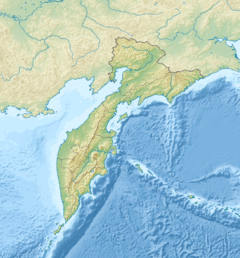
Basin of the
Penzhina with its two main tributaries
274:
266:
254:
246:
236:
197:
185:
171:
132:
116:
108:
99:
89:
77:
67:
62:
21:
518:Toponymic dictionary of the North-East of the USSR
451:growing along the river banks in the floodplain.
698:This article related to a river in Russia is a
723:
670:
8:
730:
716:
677:
663:
454:Among the fish species in the river the
401:
613:
488:
280:138 m/s (4,900 cu ft/s)
258:12,600 km (4,900 sq mi)
18:
494:
492:
329:The name of the river comes from the
7:
688:
686:
631:
629:
532:
530:
528:
526:
14:
690:
633:
616:
42:
35:
16:River in Kamchatka Krai, Russia
759:Kamchatka Krai geography stubs
516:Leontiev V.V. , Novikova K.A.
199: • coordinates
134: • coordinates
1:
100:Physical characteristics
43:
702:. You can help Knowledge by
649:. You can help Knowledge by
238: • elevation
173: • elevation
602:Kamchatka Krai travel guide
118: • location
780:
685:
628:
399:
395:(Хайоклан) from the left.
276: • average
177:540 metres (1,770 ft)
299:
284:
262:
250:272 km (169 mi)
181:
104:
30:
749:Rivers of Kamchatka Krai
477:List of rivers of Russia
537:Water of Russia - Оклан
375:, at the NW end of the
306:: Ыӄлан) is a river in
645:location article is a
427:vegetation, including
407:
242:23 metres (75 ft)
221:62.55306°N 166.54722°E
156:63.57667°N 163.71750°E
405:
339:, meaning "icy way".
579:V. Yu. Neshataeva,
393:Bolshoy Chalbugchan
226:62.55306; 166.54722
217: /
161:63.57667; 163.71750
152: /
94:Penzhinsky District
764:Russia river stubs
408:
51:Mouth location in
711:
710:
658:
657:
462:deserve mention.
412:
411:
288:
287:
771:
754:Koryak Mountains
732:
725:
718:
694:
687:
679:
672:
665:
637:
630:
621:
620:
619:
612:
584:
577:
571:
566:
560:
559:
557:
555:
545:
539:
534:
521:
514:
508:
507:
496:
398:
397:
377:Koryak Highlands
359:were engaged in
301:
277:
232:
231:
229:
228:
227:
222:
218:
215:
214:
213:
210:
174:
167:
166:
164:
163:
162:
157:
153:
150:
149:
148:
145:
135:
127:Koryak Highlands
119:
46:
45:
39:
19:
779:
778:
774:
773:
772:
770:
769:
768:
739:
738:
737:
736:
684:
683:
627:
617:
615:
607:
593:
588:
587:
578:
574:
567:
563:
553:
551:
547:
546:
542:
535:
524:
515:
511:
498:
497:
490:
485:
468:
417:
415:Flora and fauna
369:
345:
275:
239:
225:
223:
219:
216:
211:
208:
206:
204:
203:
200:
172:
160:
158:
154:
151:
146:
143:
141:
139:
138:
133:
125:
117:
79:Federal subject
58:
57:
56:
55:
49:
48:
47:
26:
23:
17:
12:
11:
5:
777:
775:
767:
766:
761:
756:
751:
741:
740:
735:
734:
727:
720:
712:
709:
708:
695:
682:
681:
674:
667:
659:
656:
655:
643:Kamchatka Krai
638:
626:
625:
605:
604:
599:
592:
591:External links
589:
586:
585:
572:
561:
540:
522:
509:
487:
486:
484:
481:
480:
479:
474:
467:
464:
416:
413:
410:
409:
368:
365:
344:
341:
316:drainage basin
308:Kamchatka Krai
286:
285:
282:
281:
278:
272:
271:
268:
264:
263:
260:
259:
256:
252:
251:
248:
244:
243:
240:
237:
234:
233:
201:
198:
195:
194:
189:
183:
182:
179:
178:
175:
169:
168:
136:
130:
129:
120:
114:
113:
110:
106:
105:
102:
101:
97:
96:
91:
87:
86:
84:Kamchatka Krai
81:
75:
74:
69:
65:
64:
60:
59:
53:Kamchatka Krai
50:
41:
40:
34:
33:
32:
31:
28:
27:
24:
15:
13:
10:
9:
6:
4:
3:
2:
776:
765:
762:
760:
757:
755:
752:
750:
747:
746:
744:
733:
728:
726:
721:
719:
714:
713:
707:
705:
701:
696:
693:
689:
680:
675:
673:
668:
666:
661:
660:
654:
652:
648:
644:
639:
636:
632:
624:
614:
610:
603:
600:
598:
595:
594:
590:
582:
576:
573:
570:
565:
562:
550:
544:
541:
538:
533:
531:
529:
527:
523:
519:
513:
510:
506:(in Russian).
505:
501:
495:
493:
489:
482:
478:
475:
473:
472:Bering tundra
470:
469:
465:
463:
461:
457:
452:
450:
446:
442:
438:
434:
430:
426:
422:
414:
404:
400:
396:
394:
390:
384:
382:
378:
374:
373:Ichigem Range
366:
364:
362:
358:
354:
350:
342:
340:
338:
335:
332:
327:
325:
321:
317:
313:
309:
305:
297:
293:
283:
279:
273:
269:
265:
261:
257:
253:
249:
245:
241:
235:
230:
202:
196:
193:
190:
188:
184:
180:
176:
170:
165:
137:
131:
128:
124:
123:Ichigem Range
121:
115:
111:
107:
103:
98:
95:
92:
88:
85:
82:
80:
76:
73:
70:
66:
61:
54:
38:
29:
25:Оклан / Ыӄлан
20:
704:expanding it
697:
651:expanding it
640:
580:
575:
569:Google Earth
564:
552:. Retrieved
543:
517:
512:
503:
453:
443:. There are
437:dwarf shrubs
418:
385:
370:
346:
336:
333:
328:
291:
289:
554:24 February
224: /
212:166°32′50″E
159: /
147:163°43′03″E
743:Categories
504:textual.ru
483:References
421:permafrost
381:floodplain
322:after the
255:Basin size
209:62°33′11″N
144:63°34′36″N
389:Khayoklam
267:Discharge
466:See also
460:grayling
458:and the
361:reindeer
347:Russian
320:Penzhina
192:Penzhina
90:District
63:Location
449:poplars
445:birches
433:lichens
357:Koryaks
353:Aklansk
349:Cossack
343:History
337:(Ыӄлан)
334:"yalan"
296:Russian
68:Country
623:Russia
609:Portal
441:sedges
439:, and
429:mosses
425:tundra
367:Course
331:Koryak
324:Belaya
312:Russia
304:Koryak
270:
247:Length
112:
109:Source
72:Russia
641:This
423:with
300:Оклан
292:Oklan
187:Mouth
22:Oklan
700:stub
647:stub
556:2022
456:pike
447:and
290:The
745::
525:^
502:.
491:^
435:,
431:,
326:.
310:,
302:;
298::
731:e
724:t
717:v
706:.
678:e
671:t
664:v
653:.
611::
558:.
294:(
Text is available under the Creative Commons Attribution-ShareAlike License. Additional terms may apply.