54:
1119:
559:
468:
492:
504:
535:
480:
41:
547:
523:
61:
430:
granted the area to
Hungary and it was held by Hungary until 1945. After Soviet occupation in 1945, Czechoslovak administration returned and the village became officially part of Czechoslovakia in 1947. The present municipality was formed in 1976 when Opatovský Sokolec (Apácaszakállas) and Okoč
369:
In 1910, the village had 544, for the most part, Hungarian inhabitants. At the 2001 Census the recorded population of the village was 3804 while an end-2008 estimate by the
Statistical Office had the village's population as 3794. As of 2001, 92.53% of its population were
1143:
1138:
752:
858:
725:
745:
1063:
738:
1088:
878:
418:
and the Small-Danube. After the Austro-Hungarian army disintegrated in
November 1918, Czechoslovak troops occupied the area. After the
85:
933:
220:
717:
696:
53:
643:
558:
762:
260:
138:
853:
671:
611:
583:
467:
210:
491:
503:
1083:
1018:
371:
928:
534:
479:
1068:
1048:
873:
1058:
958:
828:
883:
1078:
973:
868:
427:
382:
is the majority religion of the village, its adherents numbering 60.52% of the total population.
292:
247:
235:
774:
431:(Ekecs) were unified following the merger of the respective agricultural co-operatives in 1973.
1093:
983:
795:
419:
411:
379:
923:
730:
402:. The village was first recorded in 1468 as the estate of the Dóczy family. Until the end of
1073:
993:
888:
286:
1053:
781:
1108:
808:
546:
423:
1132:
1043:
968:
903:
522:
264:
128:
788:
440:
414:. Until the end of the 19th century, villagers made their living by fishing on the
256:
1098:
893:
863:
1023:
998:
978:
943:
848:
818:
612:"Hustota obyvateľstva - obce [om7014rr_ukaz: Rozloha (Štvorcový meter)]"
403:
1118:
700:
938:
908:
838:
823:
100:
87:
726:
Local election 2010 results by the
Statistical Office of the Slovak Republic
918:
913:
843:
833:
803:
1028:
1013:
948:
813:
444:
268:
1103:
1038:
988:
953:
407:
395:
391:
375:
252:
40:
1033:
1003:
898:
415:
1144:
Municipalities in
Slovakia where Hungarian is an official language
963:
678:(in Slovak). Statistical Office of the Slovak Republic. 2022-03-31
650:(in Slovak). Statistical Office of the Slovak Republic. 2015-04-17
618:(in Slovak). Statistical Office of the Slovak Republic. 2022-03-31
590:(in Slovak). Statistical Office of the Slovak Republic. 2022-03-31
448:
734:
279:
The municipality comprises the following villages and manors:
1139:
Villages and municipalities in
Dunajská Streda District
398:
was first mentioned in 1268 by it
Hungarian name as
219:
209:
199:
191:
186:
178:
170:
165:
157:
152:
144:
134:
124:
116:
21:
584:"Počet obyvateľov podľa pohlavia - obce (ročne)"
422:of 1920, the village became officially part of
746:
8:
638:
636:
634:
632:
753:
739:
731:
564:The Komárom-channel at Nový Goľáš (Gólyás)
410:and fell within the Csallóköz district of
281:
18:
718:Local news selection at www.parameter.hu
575:
518:
463:
218:
198:
185:
177:
164:
151:
143:
115:
80:
46:
37:
606:
604:
246:
208:
190:
174:63.42 km (24.49 sq mi)
169:
156:
133:
123:
7:
697:"Urban and Municipal Statistics MOŠ"
666:
664:
473:The village hall built in the 1980s
515:Opatovský Sokolec (Apácaszakállas)
497:The corner of Laki and Main street
14:
1117:
557:
545:
533:
521:
509:The Roman Catholic parish church
502:
490:
478:
466:
59:
52:
39:
1:
672:"Hustota obyvateľstva - obce"
540:The Hungarian reformed church
485:The Hungarian Reformed church
447:of 112 metres and covers an
73:Location of Okoč in Slovakia
60:
1160:
644:"Základná charakteristika"
1115:
769:
81:
47:
38:
31:
763:Dunajská Streda District
426:. In November 1938, the
261:Dunajská Streda District
182:112 m (367 ft)
239:
703:on February 26, 2011.
315:Jánošíkovo na Ostrove
451:of 63.426 km².
934:Kráľovičove Kračany
97: /
16:Village in Slovakia
1069:Trstená na Ostrove
1049:Štvrtok na Ostrove
761:Municipalities of
428:First Vienna Award
392:historical records
275:Component villages
192: • Total
171: • Total
158: • Mayor
1126:
1125:
1094:Vojka nad Dunajom
984:Michal na Ostrove
829:Blatná na Ostrove
676:www.statistics.sk
648:www.statistics.sk
616:www.statistics.sk
588:www.statistics.sk
420:Treaty of Trianon
406:, it was part of
380:Roman Catholicism
374:while 6.07% were
362:
361:
299:Opatovský Sokolec
229:
228:
101:47.883°N 17.817°E
1151:
1121:
929:Kostolné Kračany
755:
748:
741:
732:
721:
705:
704:
699:. Archived from
693:
687:
686:
684:
683:
668:
659:
658:
656:
655:
640:
627:
626:
624:
623:
608:
599:
598:
596:
595:
580:
561:
549:
537:
525:
506:
494:
482:
470:
282:
250:
248:[ˈɛkɛtʃ]
245:
112:
111:
109:
108:
107:
102:
98:
95:
94:
93:
90:
63:
62:
56:
43:
19:
1159:
1158:
1154:
1153:
1152:
1150:
1149:
1148:
1129:
1128:
1127:
1122:
1113:
874:Dunajský Klátov
854:Čiližská Radvaň
775:Dunajská Streda
765:
759:
719:
714:
709:
708:
695:
694:
690:
681:
679:
670:
669:
662:
653:
651:
642:
641:
630:
621:
619:
610:
609:
602:
593:
591:
582:
581:
577:
572:
565:
562:
553:
550:
541:
538:
529:
526:
516:
510:
507:
498:
495:
486:
483:
474:
471:
461:
457:
455:Picture gallery
437:
388:
367:
302:Apácaszakállas
277:
243:
205:
145:First mentioned
139:Dunajská Streda
105:
103:
99:
96:
91:
88:
86:
84:
83:
77:
76:
75:
74:
71:
70:
69:
68:
64:
34:
27:
24:
17:
12:
11:
5:
1157:
1155:
1147:
1146:
1141:
1131:
1130:
1124:
1123:
1116:
1114:
1112:
1111:
1106:
1101:
1096:
1091:
1086:
1084:Veľké Dvorníky
1081:
1076:
1071:
1066:
1061:
1059:Trhová Hradská
1056:
1051:
1046:
1041:
1036:
1031:
1026:
1021:
1019:Orechová Potôň
1016:
1011:
1006:
1001:
996:
991:
986:
981:
976:
971:
966:
961:
959:Lúč na Ostrove
956:
951:
946:
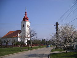
941:
936:
931:
926:
921:
916:
911:
906:
901:
896:
891:
886:
881:
876:
871:
866:
861:
856:
851:
846:
841:
836:
831:
826:
821:
816:
811:
806:
800:
799:
792:
785:
778:
770:
767:
766:
760:
758:
757:
750:
743:
735:
729:
728:
723:
720:(in Hungarian)
713:
712:External links
710:
707:
706:
688:
660:
628:
600:
574:
573:
571:
568:
567:
566:
563:
556:
554:
551:
544:
542:
539:
532:
530:
527:
520:
514:
512:
511:
508:
501:
499:
496:
489:
487:
484:
477:
475:
472:
465:
459:
456:
453:
436:
433:
424:Czechoslovakia
412:Komárom County
387:
384:
366:
363:
360:
359:
356:
352:
351:
348:
344:
343:
342:Nagyszegmajor
340:
336:
335:
332:
328:
327:
324:
320:
319:
316:
312:
311:
308:
304:
303:
300:
296:
295:
289:
276:
273:
267:of south-west
227:
226:
223:
217:
216:
213:
207:
206:
203:
201:
197:
196:
193:
189:
188:
184:
183:
180:
176:
175:
172:
168:
167:
163:
162:
159:
155:
154:
150:
149:
146:
142:
141:
136:
132:
131:
126:
122:
121:
118:
114:
113:
106:47.883; 17.817
79:
78:
72:
66:
65:
58:
57:
51:
50:
49:
48:
45:
44:
36:
35:
32:
29:
28:
25:
22:
15:
13:
10:
9:
6:
4:
3:
2:
1156:
1145:
1142:
1140:
1137:
1136:
1134:
1120:
1110:
1107:
1105:
1102:
1100:
1097:
1095:
1092:
1090:
1087:
1085:
1082:
1080:
1079:Veľké Blahovo
1077:
1075:
1072:
1070:
1067:
1065:
1062:
1060:
1057:
1055:
1052:
1050:
1047:
1045:
1042:
1040:
1037:
1035:
1032:
1030:
1027:
1025:
1022:
1020:
1017:
1015:
1012:
1010:
1007:
1005:
1002:
1000:
997:
995:
992:
990:
987:
985:
982:
980:
977:
975:
974:Malé Dvorníky
972:
970:
967:
965:
962:
960:
957:
955:
952:
950:
947:
945:
942:
940:
937:
935:
932:
930:
927:
925:
922:
920:
917:
915:
912:
910:
907:
905:
904:Hviezdoslavov
902:
900:
897:
895:
892:
890:
887:
885:
882:
880:
877:
875:
872:
870:
867:
865:
862:
860:
857:
855:
852:
850:
847:
845:
842:
840:
837:
835:
832:
830:
827:
825:
822:
820:
817:
815:
812:
810:
807:
805:
802:
801:
798:
797:
793:
791:
790:
786:
784:
783:
779:
777:
776:
772:
771:
768:
764:
756:
751:
749:
744:
742:
737:
736:
733:
727:
724:
722:
716:
715:
711:
702:
698:
692:
689:
677:
673:
667:
665:
661:
649:
645:
639:
637:
635:
633:
629:
617:
613:
607:
605:
601:
589:
585:
579:
576:
569:
560:
555:
548:
543:
536:
531:
524:
519:
517:
505:
500:
493:
488:
481:
476:
469:
464:
462:
454:
452:
450:
446:
442:
434:
432:
429:
425:
421:
417:
413:
409:
405:
401:
397:
393:
385:
383:
381:
377:
373:
364:
357:
354:
353:
349:
346:
345:
341:
338:
337:
333:
330:
329:
325:
322:
321:
317:
314:
313:
309:
306:
305:
301:
298:
297:
294:
290:
288:
284:
283:
280:
274:
272:
270:
266:
265:Trnava Region
262:
258:
254:
249:
241:
237:
233:
224:
222:
214:
212:
202:
194:
181:
173:
160:
147:
140:
137:
130:
127:
119:
110:
82:Coordinates:
55:
42:
30:
20:
1008:
794:
787:
780:
773:
701:the original
691:
680:. Retrieved
675:
652:. Retrieved
647:
620:. Retrieved
615:
592:. Retrieved
587:
578:
513:
460:Okoč (Ekecs)
458:
441:municipality
438:
399:
389:
368:
350:Túzokpuszta
310:Aszódpuszta
278:
257:municipality
231:
230:
215:+421 31
161:László Polák
1109:Zlaté Klasy
944:Kvetoslavov
884:Horná Potôň
819:Bellova Ves
796:Veľký Meder
552:WW memorial
443:lies at an
404:World War I
204:930 28
200:Postal code
104: /
1133:Categories
1074:Veľká Paka
994:Nový Život
889:Horné Mýto
869:Dolný Štál
682:2022-03-31
654:2022-03-31
622:2022-03-31
594:2022-03-31
570:References
372:Hungarians
365:Demography
331:Nový Goľáš
244:pronounced
187:Population
153:Government
1054:Topoľníky
894:Horný Bar
864:Dolný Bar
859:Dobrohošť
782:Gabčíkovo
528:Landscape
435:Geography
339:Veľký Sek
293:Hungarian
236:Hungarian
221:Car plate
211:Area code
179:Elevation
979:Medveďov
949:Kyselica
924:Kľúčovec
849:Čenkovce
445:altitude
358:Viharos
269:Slovakia
135:District
120:Slovakia
1104:Vydrany
1064:Trnávka
1039:Rohovce
989:Mierovo
954:Lehnice
939:Kútniky
909:Jahodná
839:Boheľov
824:Blahová
789:Šamorín
408:Hungary
396:village
386:History
376:Slovaks
355:Viharoš
334:Gólyás
263:in the
259:in the
253:village
251:) is a
117:Country
92:17°49′E
89:47°53′N
33:Village
1099:Vrakúň
1089:Vieska
1034:Povoda
1004:Ohrady
919:Jurová
914:Janíky
899:Hubice
879:Holice
844:Čakany
834:Bodíky
416:Danube
347:Dropie
326:Ekecs
287:Slovak
129:Trnava
125:Region
1029:Pataš
1024:Padáň
1014:Oľdza
999:Ňárad
964:Macov
814:Baloň
400:Ekech
318:Béle
240:Ekecs
195:3,710
26:Ekecs
1009:Okoč
809:Baka
449:area
439:The
394:the
323:Okoč
307:Asód
255:and
232:Okoč
166:Area
148:1268
67:Okoč
23:Okoč
1044:Sap
969:Mad
804:Báč
390:In
291:In
285:In
1135::
674:.
663:^
646:.
631:^
614:.
603:^
586:.
378:.
271:.
242:,
238::
225:DS
754:e
747:t
740:v
685:.
657:.
625:.
597:.
234:(
Text is available under the Creative Commons Attribution-ShareAlike License. Additional terms may apply.