721:
647:
685:
63:
39:
659:
697:
1003:
709:
671:
533:
635:
1220:
84:
70:
414:, which meant that South Head became important as an observation post. The outer edge of South Head became a signal station from which ships could be seen; their approach could then be signalled with flags. The ships could then be met by pilots who were camped at Camp Cove (so named for that reason).
373:
Old South Head Road passes through predominantly residential areas, with sizeable shopping centres around the intersections with Towns Road and Dover Road. Housing varies from detached homes to blocks of flats and units. The style of housing includes
1135:
An Act to amend the Main Roads Act, 1924-1927; to confer certain further powers upon the Main Roads Board; to amend the Local
Government Act, 1919, and certain other Acts; to validate certain payments and other matters; and for purposes connected
579:
area. Poor record keeping means the earliest recorded interment was in 1869. Some of the first
Trustees of the cemetery in 1845 were Henry Gibson (Pilot of Watsons Bay), Richard Siddins, Rev L. E. Threlkeld. Well-known inhabitants include
410:, at the spot now known as Circular Quay. One of the reasons for the choice of that location was the desire to be safely out of range of hostile artillery. The colony needed to keep watch on the seas for potentially hostile ships or the
1158:
An Act to make provision with respect to the roads of New South Wales; to repeal the State Roads Act 1986, the Crown and Other Roads Act 1990 and certain other enactments; and for other purposes.
429:. It has been in continuous use since then and is now heritage-listed. In 1858, the first telegraph line in New South Wales was used to connect the signal station with the Royal Exchange in
425:, the first notable architect in the colony. A semaphore system replaced flags at the signal station in the 1840s and the present building was constructed to a design by Colonial Architect
1251:
720:
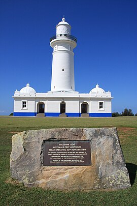
552:: the present lighthouse is a replica of Greenway's original building, which was demolished because it was in bad repair. The current building was built in 1883 to a design by
1029:
479:
updated road classifications and the way they could be declared within New South Wales. Under this act, Old South Head Road retains its declaration as Main Road 339.
1182:
1113:
An Act to provide for the better construction, maintenance, and financing of main roads; to provide for developmental roads; to constitute a Main Roads Board
627:
A two-storey
Victorian terrace home near Bondi Road now houses the Mahasiddha Kadampa Buddhist Centre, which holds meditation courses and drop-in classes.
111:
457:
144:
1244:
646:
421:. Construction of a road followed and it was completed in 1811. A lighthouse was built just south of the signal station in 1816-18, to a design by
603:
Former
Methodist Church, built 1924, currently houses Magnolia Healing Centre. It is located at the corner of Old South Head Road and Dover Road,
62:
1161:
1116:
1237:
1224:
546:
is situated between Gap Park and Signal
Station. The site includes two gun emplacements that are connected to underground bunker complexes.
1139:
658:
708:
696:
1724:
1563:
521:
Sandstone obelisk, Robertson Park (not situated in Old South Head Road), commemorating building of Old South Head Road in 1811 (RNE)
1067:
830:
791:
771:
491:
907:
856:
834:
417:
A proper signal station was established in 1790; it was supplied by boat until a bridle trail was created along the ridge to
684:
634:
441:
505:
Our Lady Star of the Sea
Catholic Church, Watsons Bay, built 1909–1910, with later additions in 1929, 1940 and 1966 (RNE)
1528:
1467:
961:
949:
926:
886:
868:
864:
283:
102:
1457:
930:
847:
813:
795:
670:
418:
311:
1719:
1282:
809:
775:
620:
blocks of flats, single-storey
Federation homes and Victorian-style cottages can be seen between Victoria Road and
314:
peninsula. It is historically significant because its earliest origins can be traced back to the early days of the
1447:
944:
934:
895:
881:
860:
761:
604:
576:
363:
355:
315:
291:
287:
50:
342:
and heads in a north-easterly direction as a four-lane, single carriageway road, passing through the suburbs of
1412:
1407:
1352:
1332:
581:
411:
559:
Gap Park is situated between Old South Head Road and the cliff, and leads to the Gap, a notorious suicide spot
1327:
1292:
1007:
375:
511:
A former school residence, next to the scout hall, designed by George
Mansfield and built by George Murray
1477:
1337:
1302:
821:
610:
597:
379:
343:
1688:
1663:
1568:
1462:
1427:
1417:
1387:
1357:
1297:
1287:
1155:
787:
461:
430:
327:
219:
444:
provided for the declaration of Main Roads, roads partially funded by the State government through the
38:
1673:
1608:
1553:
1498:
1342:
1098:
549:
46:
1110:
1618:
1503:
1482:
1452:
1432:
1402:
1397:
1392:
922:
572:
568:
543:
536:
359:
249:
1643:
1578:
1538:
1382:
1312:
1229:
508:
Scout hall, Watsons Bay, formerly a school, designed by George
Mansfield and built in 1876 (RNE)
1678:
1603:
1583:
1558:
1322:
1178:
805:
525:
449:
331:
239:
1132:
1683:
1658:
1633:
1593:
1372:
1362:
1307:
765:
445:
422:
1002:
1653:
1638:
1513:
1367:
1317:
1265:
1165:
1143:
1120:
593:
366:, continuing north until it eventually terminates at a roundabout with Robertson Place in
29:
607:, and is supported by Bondi Beach Chapel by the Sea and Rose Bay/Vaucluse Uniting Church.
1648:
1613:
1598:
1573:
1543:
1533:
1518:
1472:
1437:
1274:
1059:
589:
556:. The group also includes the keeper's cottage and an earlier cottage by Greenway (RNE)
532:
499:
465:
426:
403:
339:
303:
225:
200:
1713:
1698:
1623:
1508:
1377:
585:
460:(having succeeded the MRB in 1932) declared Main Road 339 from the intersection with
1693:
1588:
1422:
979:
553:
406:
went ashore at what is now known as Camp Cove. The settlement itself was set up in
399:
1088:
Walks in the Sydney
Harbour National Park, Neil Paton (Kangaroo Press) 1987, p.58
562:
Coastal Cliff Walk is a walking trail that goes from Clarke Street to South head.
1548:
1442:
1347:
1034:
469:
407:
395:
367:
351:
347:
307:
267:
1523:
817:
621:
456:
to provide for additional declarations of State Highways and Trunk Roads, the
335:
244:
159:
146:
126:
113:
1668:
1066:. No. 119. National Library of Australia. 4 August 1933. p. 2883.
1219:
613:
is situated between Old South Head Road and New South Head Road, Rose Bay.
617:
383:
1261:
1206:
The Heritage of Australia, Macmillan Publishers, 1981, pp. 2/136-138
531:
1233:
575:, this cemetery was established in 1845 to service the growing
1183:"Schedule of Classified Roads and Unclassified Regional Roads"
959:
786:
565:
Christison Park is situated south of Macquarie Lighthouse
302:
is a major road in Sydney, linking the eastern suburb of
394:
The colony at Sydney began on 21 January 1788, when the
326:
Old South Head Road commences at the intersection with
571:. Situated at the juncture of Old South Head Road and
490:
indicates that the structure or site is listed on the
726:
Our Lady Star of the Sea Catholic Church, Watsons Bay
498:
St Peter's Anglican Church, Watsons bay, designed by
1491:
1273:
279:
274:
258:
232:
214:
209:
199:
191:
183:
178:
101:
23:
1064:Government Gazette of the State of New South Wales
965:
799:
1245:
1054:
1052:
739:
8:
524:Signal Station, still functional and run by
468:to the intersection with Robertson Place in
1252:
1238:
1230:
735:
640:Scout hall, formerly a school, Watsons Bay
37:
20:
386:blocks of flats towards Bondi Junction.
1024:
1022:
1018:
966:Northern terminus of road at roundabout
714:St Peter's Anglican Church, Watsons Bay
680:
630:
452:). With the subsequent passing of the
953:
921:
915:
905:
899:
879:
873:
845:
839:
804:
780:
7:
652:Former school residence, Watsons Bay
885:Curlewis Street (east) –
880:O'Sullivan Road (west) –
454:Main Roads (Amendment) Act of 1929
14:
1070:from the original on 22 June 2023
83:
69:
1218:
1001:
719:
707:
695:
683:
669:
664:Federation homes, Bondi Junction
657:
645:
633:
82:
68:
61:
49:, Australia's first lighthouse,
1188:. Government of New South Wales
492:Register of the National Estate
676:Art Deco flats, Bondi Junction
1:
512:
442:Parliament of New South Wales
1529:Burnt Bridge Creek Deviation
1225:Old South Head Road, Sydney
1097:The Heritage of Australia,
1060:"Main Roads Act, 1924-1931"
1008:Australian Roads portal
960:Robertson Place –
846:Victoria Street –
702:Lighthouse keeper's cottage
1741:
1156:State of New South Wales,
1133:State of New South Wales,
1111:State of New South Wales,
616:Architecture: examples of
1725:Vaucluse, New South Wales
970:
956:
948:
943:
938:
918:
911:
906:Military Road –
902:
894:
890:
876:
855:
851:
842:
829:
825:
800:Southern terminus of road
783:
770:
760:
755:
752:
749:
746:
743:
738:
316:colony of New South Wales
195:6.8 km (4.2 mi)
56:
45:
36:
16:Road in Sydney, Australia
975:
611:Royal Sydney Golf Course
458:Department of Main Roads
160:33.844790°S 151.282760°E
127:33.891004°S 151.253358°E
820:(southeast) –
790:(southwest) –
502:and built in 1864 (RNE)
1164:11 August 2022 at the
1142:12 August 2022 at the
1119:11 August 2022 at the
598:Walter Edward Davidson
539:
438:Main Roads Act of 1924
226:Bondi Junction, Sydney
165:-33.844790; 151.282760
132:-33.891004; 151.253358
1569:Great Western Highway
1227:at Wikimedia Commons
1030:"Old South Head Road"
535:
1674:Southern Cross Drive
1554:General Holmes Drive
1099:Macmillan Publishers
550:Macquarie Lighthouse
47:Macquarie Lighthouse
1629:Old South Head Road
1619:New South Head Road
923:New South Head Road
732:Major intersections
573:New South Head Road
569:South Head Cemetery
544:Signal Hill Battery
537:Signal Hill Battery
475:The passing of the
436:The passing of the
362:at a roundabout in
360:New South Head Road
300:Old South Head Road
268:Watsons Bay, Sydney
250:New South Head Road
179:General information
156: /
123: /
25:Old South Head Road
1644:Pennant Hills Road
1579:Henry Lawson Drive
1539:Cumberland Highway
1313:Castlereagh Street
808:(west) –
582:Sir John Robertson
540:
483:Points of interest
1720:Streets in Sydney
1707:
1706:
1679:Syd Einfeld Drive
1604:King Georges Road
1584:The Horsley Drive
1559:Gore Hill Freeway
1223:Media related to
1179:Transport for NSW
990:
989:
806:Syd Einfeld Drive
526:Transport for NSW
477:Roads Act of 1993
472:on 18 July 1933.
450:Transport for NSW
332:Syd Einfeld Drive
297:
296:
240:Syd Einfeld Drive
1732:
1684:Taren Point Road
1659:Prospect Highway
1634:Old Windsor Road
1594:James Ruse Drive
1564:Great North Road
1413:Macquarie Street
1408:Liverpool Street
1373:Grosvenor Street
1363:Glebe Point Road
1353:Elizabeth Street
1333:Cleveland Street
1254:
1247:
1240:
1231:
1222:
1207:
1204:
1198:
1197:
1195:
1193:
1187:
1175:
1169:
1168:10 November 1924
1153:
1147:
1130:
1124:
1123:10 November 1924
1108:
1102:
1095:
1089:
1086:
1080:
1079:
1077:
1075:
1056:
1047:
1046:
1044:
1042:
1026:
1006:
1005:
983:
976:
741:
736:
723:
711:
699:
687:
673:
661:
649:
637:
517:
514:
446:Main Roads Board
423:Francis Greenway
270:
228:
172: (North end)
171:
170:
168:
167:
166:
161:
157:
154:
153:
152:
149:
139: (South end)
138:
137:
135:
134:
133:
128:
124:
121:
120:
119:
116:
86:
85:
72:
71:
65:
41:
21:
1740:
1739:
1735:
1734:
1733:
1731:
1730:
1729:
1710:
1709:
1708:
1703:
1654:Princes Highway
1639:Parramatta Road
1514:Barrenjoey Road
1487:
1468:Victoria Street
1368:Goulburn Street
1328:Clarence Street
1318:Chalmers Street
1293:Bathurst Street
1269:
1266:New South Wales
1258:
1216:
1211:
1210:
1205:
1201:
1191:
1189:
1185:
1181:(August 2022).
1177:
1176:
1172:
1166:Wayback Machine
1154:
1150:
1144:Wayback Machine
1131:
1127:
1121:Wayback Machine
1109:
1105:
1101:, 1982, p.2/137
1096:
1092:
1087:
1083:
1073:
1071:
1058:
1057:
1050:
1040:
1038:
1028:
1027:
1020:
1015:
1000:
998:
992:
986:
978:
974:
884:
816:
734:
727:
724:
715:
712:
703:
700:
691:
688:
677:
674:
665:
662:
653:
650:
641:
638:
594:Juanita Nielsen
515:
485:
392:
324:
266:
265:
263:Robertson Place
254:
224:
223:
210:Major junctions
164:
162:
158:
155:
150:
147:
145:
143:
142:
131:
129:
125:
122:
117:
114:
112:
110:
109:
97:
96:
95:
94:
93:
92:
91:
87:
79:
78:
77:
73:
32:
30:New South Wales
27:
26:
17:
12:
11:
5:
1738:
1736:
1728:
1727:
1722:
1712:
1711:
1705:
1704:
1702:
1701:
1696:
1691:
1686:
1681:
1676:
1671:
1666:
1661:
1656:
1651:
1649:Pittwater Road
1646:
1641:
1636:
1631:
1626:
1621:
1616:
1614:Lane Cove Road
1611:
1606:
1601:
1599:Jeffrey Street
1596:
1591:
1586:
1581:
1576:
1574:Heathcote Road
1571:
1566:
1561:
1556:
1551:
1546:
1544:Darling Street
1541:
1536:
1534:City West Link
1531:
1526:
1521:
1519:Blacktown Road
1516:
1511:
1506:
1501:
1495:
1493:
1492:Suburban roads
1489:
1488:
1486:
1485:
1480:
1478:William Street
1475:
1473:Whitlam Square
1470:
1465:
1460:
1458:Stanley Street
1455:
1450:
1448:Queen's Square
1445:
1440:
1438:Phillip Street
1435:
1430:
1425:
1420:
1415:
1410:
1405:
1400:
1395:
1390:
1385:
1380:
1375:
1370:
1365:
1360:
1355:
1350:
1345:
1340:
1338:College Street
1335:
1330:
1325:
1320:
1315:
1310:
1305:
1303:Bayswater Road
1300:
1295:
1290:
1285:
1279:
1277:
1275:City of Sydney
1271:
1270:
1259:
1257:
1256:
1249:
1242:
1234:
1215:
1214:External links
1212:
1209:
1208:
1199:
1170:
1148:
1125:
1103:
1090:
1081:
1048:
1017:
1016:
1014:
1011:
997:
994:
988:
987:
985:
984:
971:
968:
967:
964:
958:
955:
952:
947:
941:
940:
937:
920:
917:
913:
912:
910:
904:
901:
898:
892:
891:
889:
878:
875:
872:
853:
852:
850:
844:
841:
838:
831:Bondi Junction
827:
826:
824:
802:
801:
798:
792:Bondi Junction
785:
782:
779:
772:Bondi Junction
769:
758:
757:
754:
751:
748:
745:
742:
733:
730:
729:
728:
725:
718:
716:
713:
706:
704:
701:
694:
692:
690:Signal Station
689:
682:
679:
678:
675:
668:
666:
663:
656:
654:
651:
644:
642:
639:
632:
629:
628:
625:
614:
608:
601:
590:Fairfax family
566:
563:
560:
557:
547:
530:
529:
522:
519:
509:
506:
503:
500:Edmund Blacket
484:
481:
466:Bondi Junction
427:Mortimer Lewis
404:Arthur Phillip
400:Sydney Harbour
391:
388:
340:Bondi Junction
323:
320:
304:Bondi Junction
295:
294:
281:
277:
276:
272:
271:
260:
256:
255:
253:
252:
247:
242:
236:
234:
230:
229:
216:
212:
211:
207:
206:
203:
197:
196:
193:
189:
188:
185:
181:
180:
176:
175:
174:
173:
140:
105:
99:
98:
89:
88:
81:
80:
75:
74:
67:
66:
60:
59:
58:
57:
54:
53:
43:
42:
34:
33:
28:
24:
15:
13:
10:
9:
6:
4:
3:
2:
1737:
1726:
1723:
1721:
1718:
1717:
1715:
1700:
1699:Wolseley Road
1697:
1695:
1692:
1690:
1689:Victoria Road
1687:
1685:
1682:
1680:
1677:
1675:
1672:
1670:
1667:
1665:
1664:Richmond Road
1662:
1660:
1657:
1655:
1652:
1650:
1647:
1645:
1642:
1640:
1637:
1635:
1632:
1630:
1627:
1625:
1624:Norton Street
1622:
1620:
1617:
1615:
1612:
1610:
1607:
1605:
1602:
1600:
1597:
1595:
1592:
1590:
1587:
1585:
1582:
1580:
1577:
1575:
1572:
1570:
1567:
1565:
1562:
1560:
1557:
1555:
1552:
1550:
1547:
1545:
1542:
1540:
1537:
1535:
1532:
1530:
1527:
1525:
1522:
1520:
1517:
1515:
1512:
1510:
1509:Bangor Bypass
1507:
1505:
1502:
1500:
1497:
1496:
1494:
1490:
1484:
1481:
1479:
1476:
1474:
1471:
1469:
1466:
1464:
1463:Sussex Street
1461:
1459:
1456:
1454:
1451:
1449:
1446:
1444:
1441:
1439:
1436:
1434:
1431:
1429:
1428:Oxford Street
1426:
1424:
1421:
1419:
1418:Market Street
1416:
1414:
1411:
1409:
1406:
1404:
1401:
1399:
1396:
1394:
1391:
1389:
1388:Hunter Street
1386:
1384:
1381:
1379:
1378:Harris Street
1376:
1374:
1371:
1369:
1366:
1364:
1361:
1359:
1358:George Street
1356:
1354:
1351:
1349:
1346:
1344:
1341:
1339:
1336:
1334:
1331:
1329:
1326:
1324:
1321:
1319:
1316:
1314:
1311:
1309:
1306:
1304:
1301:
1299:
1298:Bridge Street
1296:
1294:
1291:
1289:
1288:Alfred Street
1286:
1284:
1283:Albion Street
1281:
1280:
1278:
1276:
1272:
1267:
1263:
1255:
1250:
1248:
1243:
1241:
1236:
1235:
1232:
1228:
1226:
1221:
1213:
1203:
1200:
1184:
1180:
1174:
1171:
1167:
1163:
1160:
1159:
1152:
1149:
1145:
1141:
1138:
1137:
1129:
1126:
1122:
1118:
1115:
1114:
1107:
1104:
1100:
1094:
1091:
1085:
1082:
1069:
1065:
1061:
1055:
1053:
1049:
1037:
1036:
1031:
1025:
1023:
1019:
1012:
1010:
1009:
1004:
995:
993:
981:
973:
972:
969:
963:
951:
946:
942:
936:
932:
928:
924:
914:
909:
908:Dover Heights
897:
893:
888:
883:
870:
866:
862:
858:
857:Bellevue Hill
854:
849:
836:
835:Bellevue Hill
832:
828:
823:
819:
815:
811:
807:
803:
797:
793:
789:
788:Oxford Street
777:
773:
767:
763:
759:
737:
731:
722:
717:
710:
705:
698:
693:
686:
681:
672:
667:
660:
655:
648:
643:
636:
631:
626:
623:
619:
615:
612:
609:
606:
602:
599:
595:
591:
587:
586:Packer family
583:
578:
574:
570:
567:
564:
561:
558:
555:
551:
548:
545:
542:
541:
538:
534:
527:
523:
520:
510:
507:
504:
501:
497:
496:
495:
493:
489:
482:
480:
478:
473:
471:
467:
463:
462:Oxford Street
459:
455:
451:
447:
443:
439:
434:
432:
431:Bridge Street
428:
424:
420:
415:
413:
409:
405:
401:
397:
389:
387:
385:
381:
377:
371:
369:
365:
361:
357:
353:
349:
345:
341:
337:
333:
329:
328:Oxford Street
321:
319:
317:
313:
309:
305:
301:
293:
289:
285:
282:
280:Major suburbs
278:
273:
269:
264:
261:
257:
251:
248:
246:
243:
241:
238:
237:
235:
231:
227:
222:
221:
220:Oxford Street
217:
213:
208:
204:
202:
198:
194:
190:
186:
182:
177:
169:
141:
136:
108:
107:
106:
104:
100:
64:
55:
52:
48:
44:
40:
35:
31:
22:
19:
1694:Windsor Road
1628:
1589:Hume Highway
1499:Anzac Parade
1423:Martin Place
1343:Crown Street
1217:
1202:
1190:. Retrieved
1173:
1157:
1151:
1146:8 April 1929
1134:
1128:
1112:
1106:
1093:
1084:
1072:. Retrieved
1063:
1039:. Retrieved
1033:
999:
991:
977:
925: –
753:Destinations
554:James Barnet
487:
486:
476:
474:
453:
448:(MRB, later
440:through the
437:
435:
416:
412:Second Fleet
402:and Captain
393:
372:
325:
299:
298:
262:
218:
18:
1609:King Street
1549:Epping Road
1483:York Street
1453:Rowe Street
1443:Pitt Street
1433:Park Street
1403:Lime Street
1398:King Street
1393:Kent Street
1348:Eddy Avenue
1268:, Australia
1260:Streets of
1035:Google Maps
962:Watsons Bay
950:Watsons Bay
927:Kings Cross
887:Bondi Beach
871:quadripoint
869:North Bondi
865:Bondi Beach
516: 1876
470:Watsons Bay
408:Sydney Cove
398:arrived in
396:First Fleet
368:Watsons Bay
358:. It meets
352:North Bondi
348:Bondi Beach
308:Watsons Bay
284:Bondi Beach
275:Location(s)
163: /
151:151°16′58″E
130: /
118:151°15′12″E
103:Coordinates
1714:Categories
1524:Bondi Road
1504:Appian Way
1383:Hay Street
1136:therewith.
1013:References
982:transition
939:Roundabout
931:Double Bay
848:Double Bay
818:Bondi Road
814:Paddington
796:Paddington
622:Bondi Road
419:South Head
382:homes and
376:Federation
336:Bondi Road
312:South Head
245:Bondi Road
148:33°50′41″S
115:33°53′28″S
1669:Ryde Road
1323:City Road
945:Woollahra
810:Woollahra
776:Woollahra
762:Woollahra
380:Victorian
259:North end
215:South end
205:July 1933
90:North end
76:South end
1308:Broadway
1192:1 August
1162:Archived
1140:Archived
1117:Archived
1068:Archived
996:See also
935:Rose Bay
896:Vaucluse
882:Rose Bay
861:Rose Bay
837:boundary
778:boundary
768:boundary
766:Waverley
744:Location
618:Art Deco
605:Rose Bay
596:and Sir
577:Vaucluse
384:Art Deco
364:Vaucluse
356:Rose Bay
292:Vaucluse
288:Rose Bay
201:Gazetted
51:Vaucluse
1074:22 June
1041:22 June
1032:(Map).
390:History
378:homes,
310:on the
1262:Sydney
588:, the
584:, the
233:
192:Length
1186:(PDF)
980:Route
822:Bondi
756:Notes
528:(RNE)
518:(RNE)
488:(RNE)
344:Bondi
322:Route
1194:2022
1076:2023
1043:2023
877:0.99
843:0.31
354:and
334:and
187:Road
184:Type
957:4.2
954:6.8
919:3.2
916:5.1
903:2.7
900:4.4
874:1.6
840:0.5
784:0.0
781:0.0
740:LGA
464:in
338:in
306:to
1716::
1264:,
1062:.
1051:^
1021:^
933:,
929:,
812:,
794:,
750:mi
747:km
592:,
513:c.
494:.
433:.
370:.
350:,
346:,
330:,
318:.
290:,
286:,
1253:e
1246:t
1239:v
1196:.
1078:.
1045:.
867:–
863:–
859:–
833:–
774:–
764:–
624:.
600:.
Text is available under the Creative Commons Attribution-ShareAlike License. Additional terms may apply.