600:
163:
569:
579:
269:
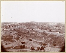
NO. 918 OLINDA - From 1897, when oil pioneer Edward L. Doheny brought in the first well, to the 1940s, the boom town of Olinda sprawled over the surrounding hills. To the north was the
Chanslor-Candfield Midway Oil Lease and, to the south, the Olinda Crude Oil Lease.
285:
206:
The name was revived for a quiet neighborhood built in the hills near the site of the original village, beginning in 1964. The neighborhood has six streets, and holds about 120 homes (many
670:
685:
675:
641:
60:
377:
680:
634:
437:
329:
665:
627:
370:
194:
137:
491:
215:
582:
538:
246:
211:
178:
660:
607:
572:
533:
528:
363:
115:
496:
442:
253:
599:
421:
219:
475:
249:
190:
186:
416:
347:
28:
203:, located in Carbon Canyon, was opened in 1960 and is scheduled to be closed in December 2021.
447:
334:
611:
386:
252:
in the area is also named Olinda. Olinda gives its name to an elementary school as well as
174:
162:
125:
49:
181:
east of the rest of the city. The original village was founded in the 1890s and grew when
470:
200:
512:
271:
654:
308:
95:
239:
105:
17:
75:
62:
554:
465:
223:
182:
189:. In February 1917, Olinda Village and the nearby town of Randolph were
227:
355:
207:
161:
235:
34:
Neighborhood of Brea in Orange County, California, United States
359:
231:
286:
California
Historical Landmarks in Orange County, California
311:. Office of Historic Preservation, California State Parks
615:
274:, of Baseball's Hall of Fame, spent his boyhood here.
547:
521:
505:
484:
458:
430:
409:
393:
193:as the city of Brea. The site is now registered as
144:
135:
121:
111:
101:
91:
39:
635:
371:
8:
671:Neighborhoods in Orange County, California
642:
628:
378:
364:
356:
36:
686:Orange County, California geography stubs
676:Populated places established in the 1890s
348:californiahistoricallandmarks.com chl-918
297:
222:, and surrounded by hills covered with
90:
76:33.92414785100306°N 117.8476746137632°W
303:
301:
260:California Historical Landmark Marker
143:
134:
120:
110:
100:
81:33.92414785100306; -117.8476746137632
7:
596:
594:
578:
197:#918 registered on January 1. 1978.
438:Brea Olinda Unified School District
330:Rural life, tucked away in the O.C.
614:. You can help Knowledge (XXG) by
25:
598:
577:
568:
567:
256:, which serves Brea and Olinda.
681:California Historical Landmarks
185:was discovered at the adjacent
195:California Historical Landmark
138:California Historical Landmark
1:
431:Primary and secondary schools
166:Oil wells in Olinda in 1900
492:Carbon Canyon Regional Park
216:Carbon Canyon Regional Park
702:
593:
247:Southern California Edison
26:
608:Orange County, California
563:
156:
152:
131:
56:
46:
666:Chino Hills (California)
448:Olinda Elementary School
27:Not to be confused with
497:Brea City Hall and Park
443:Brea Olinda High School
254:Brea-Olinda High School
610:–related article is a
422:Brea Police Department
220:Chino Hills State Park
167:
476:Brea-Olinda Oil Field
250:electrical substation
187:Brea-Olinda Oil Field
173:is a neighborhood in
165:
548:Company headquarters
417:Brea Fire Department
410:Municipal government
272:Walter Perry Johnson
214:complex. It is near
210:properties), and a
72: /
179:Carbon Canyon Road
168:
145:Reference no.
29:Orinda, California
623:
622:
591:
590:
335:Los Angeles Times
160:
159:
16:(Redirected from
693:
661:Brea, California
644:
637:
630:
602:
595:
581:
580:
571:
570:
387:Brea, California
380:
373:
366:
357:
350:
345:
339:
338:August 14, 2005
326:
320:
319:
317:
316:
305:
175:Brea, California
126:Brea, California
87:
86:
84:
83:
82:
77:
73:
70:
69:
68:
65:
48:Neighborhood of
37:
21:
701:
700:
696:
695:
694:
692:
691:
690:
651:
650:
649:
648:
592:
587:
559:
543:
517:
501:
480:
471:Olinda Landfill
454:
426:
405:
389:
384:
354:
353:
346:
342:
327:
323:
314:
312:
307:
306:
299:
294:
282:
262:
201:Olinda Landfill
140:
80:
78:
74:
71:
66:
63:
61:
59:
58:
52:
42:
35:
32:
23:
22:
15:
12:
11:
5:
699:
697:
689:
688:
683:
678:
673:
668:
663:
653:
652:
647:
646:
639:
632:
624:
621:
620:
603:
589:
588:
586:
585:
575:
564:
561:
560:
558:
557:
551:
549:
545:
544:
542:
541:
536:
531:
525:
523:
519:
518:
516:
515:
513:Olinda Village
509:
507:
503:
502:
500:
499:
494:
488:
486:
482:
481:
479:
478:
473:
468:
462:
460:
456:
455:
453:
452:
451:
450:
445:
434:
432:
428:
427:
425:
424:
419:
413:
411:
407:
406:
404:
403:
397:
395:
391:
390:
385:
383:
382:
375:
368:
360:
352:
351:
340:
321:
296:
295:
293:
290:
289:
288:
281:
278:
277:
276:
264:Marker reads:
261:
258:
158:
157:
154:
153:
150:
149:
146:
142:
141:
136:
133:
132:
129:
128:
123:
119:
118:
113:
109:
108:
103:
99:
98:
93:
89:
88:
54:
53:
47:
44:
43:
40:
33:
24:
18:Olinda Village
14:
13:
10:
9:
6:
4:
3:
2:
698:
687:
684:
682:
679:
677:
674:
672:
669:
667:
664:
662:
659:
658:
656:
645:
640:
638:
633:
631:
626:
625:
619:
617:
613:
609:
604:
601:
597:
584:
576:
574:
566:
565:
562:
556:
553:
552:
550:
546:
540:
537:
535:
532:
530:
527:
526:
524:
520:
514:
511:
510:
508:
506:Neighborhoods
504:
498:
495:
493:
490:
489:
487:
483:
477:
474:
472:
469:
467:
464:
463:
461:
457:
449:
446:
444:
441:
440:
439:
436:
435:
433:
429:
423:
420:
418:
415:
414:
412:
408:
402:
399:
398:
396:
392:
388:
381:
376:
374:
369:
367:
362:
361:
358:
349:
344:
341:
337:
336:
331:
325:
322:
310:
304:
302:
298:
291:
287:
284:
283:
279:
275:
273:
267:
266:
265:
259:
257:
255:
251:
248:
243:
241:
237:
233:
229:
225:
221:
217:
213:
209:
204:
202:
198:
196:
192:
188:
184:
180:
177:, located on
176:
172:
164:
155:
151:
147:
139:
130:
127:
124:
117:
116:Orange County
114:
107:
104:
97:
96:United States
94:
85:
57:Coordinates:
55:
51:
45:
38:
30:
19:
616:expanding it
605:
400:
343:
333:
328:Tony Dodero
324:
313:. Retrieved
268:
263:
244:
240:rattlesnakes
226:and home to
205:
199:
191:incorporated
170:
169:
212:condominium
79: /
67:117°50′52″W
655:Categories
315:2012-10-11
292:References
106:California
64:33°55′27″N
555:ViewSonic
466:Brea Mall
459:Landmarks
224:chaparral
183:petroleum
573:Category
309:"Olinda"
280:See also
583:Commons
228:coyotes
92:Country
539:SR 142
401:Olinda
171:Olinda
112:County
41:Olinda
606:This
534:SR 90
529:SR 57
522:Roads
485:Parks
394:Areas
236:hawks
208:horse
102:State
612:stub
238:and
232:owls
218:and
122:City
50:Brea
148:918
657::
332:,
300:^
245:A
242:.
234:,
230:,
643:e
636:t
629:v
618:.
379:e
372:t
365:v
318:.
31:.
20:)
Text is available under the Creative Commons Attribution-ShareAlike License. Additional terms may apply.