43:
68:
734:Дума Корякского автономного округа. Закон №339-оз от 9 ноября 2004 г. «О территории и границах муниципального образования "Олюторский муниципальный район"», в ред. Закона №211 от 4 марта 2013 г. «О внесении изменений в отдельные законодательные акты Корякского автономного округа и Камчатского края и о признании утратившими силу отдельных законодательных актов Корякского автономного округа и Камчатского края в связи с упразднением сельского поселения "село Корф"». Вступил в силу через 10 дней после официального опубликования. Опубликован: "Народовластие", №95, 24 ноября 2004 г.
58:
275:
718:Законодательное Собрание Камчатского края. Закон №46 от 29 апреля 2008 г. «Об административно-территориальном устройстве Камчатского края», в ред. Закона №659 от 30 июля 2015 г. «О внесении изменения в статью 5 Закона Камчатского края "Об административно-территориальном устройстве Камчатского края"». Вступил в силу со дня официального опубликования. Опубликован: "Официальные Ведомости", №65-69, 6 мая 2008 г.
857:
871:
849:
832:
758:
42:
658:Численность населения России, субъектов Российской Федерации в составе федеральных округов, районов, городских поселений, сельских населённых пунктов – районных центров и сельских населённых пунктов с населением 3 тысячи и более человек
685:[All Union Population Census of 1989: Present Population of Union and Autonomous Republics, Autonomous Oblasts and Okrugs, Krais, Oblasts, Districts, Urban Settlements, and Villages Serving as District Administrative Centers].
743:
On
Amending Various Legislative Acts of Koryak Autonomous Okrug and Kamchatka Krai and on Abrogating Various Legislative Acts of Koryak Autonomous Okrug and Kamchatka Krai Due to the Abolition of the Rural Settlement of the "Selo of
682:Всесоюзная перепись населения 1989 г. Численность наличного населения союзных и автономных республик, автономных областей и округов, краёв, областей, районов, городских поселений и сёл-райцентров
661:[Population of Russia, Its Federal Districts, Federal Subjects, Districts, Urban Localities, Rural Localities—Administrative Centers, and Rural Localities with Population of Over 3,000]
67:
790:
953:
930:
333:
652:
598:
921:
57:
345:
223:
217:
1103:
783:
91:
626:
414:. Lantzeff speaks also of the Olyutora River, which does not appear on modern maps and which he distinguishes from the Pakhacha. The
340:. It is located in the northeast of the krai. The area of the district is 72,352 square kilometers (27,935 sq mi). Its
762:
689:(in Russian). Институт демографии Национального исследовательского университета: Высшая школа экономики . 1989 – via
776:
914:
727:
On
Amending Article 5 of the Law of Kamchatka Krai "On the Administrative-Territorial Structure of Kamchatka Krai"
131:
987:
821:
407:
1047:
948:
588:
992:
907:
250:
237:
1067:
943:
341:
143:
560:
391:
1026:
1016:
997:
982:
972:
841:
810:
369:
361:
33:
977:
817:
721:(Legislative Assembly of Kamchatka Krai. Law #46 of April 29, 2008
419:
395:
377:
737:(Duma of Koryak Autonomous Okrug. Law #339-oz of November 9, 2004
452:. It was besieged by the Yukaghirs and Koryaks. It lost its importance after the sea route from
274:
1031:
967:
739:
On the
Territory and the Borders of the Municipal Formation of "Olyutorsky Municipal District"
440:
427:
899:
309:
473:
768:
1075:
934:
486:
423:
325:
269:
136:
1097:
415:
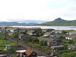
382:. The population of Tilichiki accounts for 34.6% of the district's total population.
1008:
656:
510:
449:
321:
746:. Effective as of the day which is ten days after the official publication.).
1052:
680:
883:
504:
444:(fortress) of Olyutorsk to control the coast and land route from Kamchatka to
411:
399:
201:
190:
106:
93:
355:
297:
260:
148:
757:
1080:
1057:
480:
465:
445:
403:
492:
469:
453:
350:
265:
329:
703:
George V. Lantzeff and
Richard A. Price. 'Eastward to Empire'. 1973
741:, as amended by the Law #211 of March 4, 2013
725:, as amended by the Law #659 of July 30, 2015
498:
317:
283:
337:
903:
772:
82:
Location of
Olyutorsky District in Koryak Okrug, Kamchatka Krai
729:. Effective as of the day of the official publication.).
723:
593:[2010 All-Russian Population Census, vol. 1].
612:
610:
608:
476:, some of whom had been brought south by the Russians.
590:Всероссийская перепись населения 2010 года. Том 1
426:
mountain chains, as well as the southern part of the
398:, having their headwaters close to the north-flowing
472:
lived in the area or somewhat west. There were also
1066:
1040:
1006:
960:
293:
282:
259:
248:
234:
229:
215:
210:
199:
188:
180:
172:
167:
159:
154:
142:
130:
122:
21:
587:Russian Federal State Statistics Service (2011).
667:Всероссийская перепись населения 2002 года
595:Всероссийская перепись населения 2010 года
543:
541:
539:
537:
535:
631:Официальный интернет-портал правовой информации
316:) is an administrative and municipal district (
915:
784:
732:
716:
687:Всесоюзная перепись населения 1989 года
8:
582:
580:
578:
922:
908:
900:
791:
777:
769:
273:
18:
390:The major rivers in the district are the
298:http://xn----8sbwecbgwbbgrejm5q.xn--p1ai/
255:0 urban settlements, 7 rural settlements
555:
553:
531:
292:
258:
228:
209:
166:
163:72,352 km (27,935 sq mi)
153:
141:
121:
86:
79:
51:
39:
799:Places adjacent to Olyutorsky District
281:
247:
233:
214:
198:
187:
179:
171:
158:
129:
7:
806:
16:District in Kamchatka Krai, Russia
14:
563:(in Russian). Olyutorsky District
869:
855:
847:
830:
756:
653:Federal State Statistics Service
599:Federal State Statistics Service
66:
56:
41:
1:
870:
831:
244:Olyutorsky Municipal District
856:
848:
448:; a function it shared with
438:In 1714, Russians built the
1104:Districts of Kamchatka Krai
47:Pakhachi, Dunkin Navel hill
1120:
633:(in Russian). June 3, 2011
184:0.070/km (0.18/sq mi)
941:
822:Chukotka Autonomous Okrug
804:
733:
717:
313:
87:
80:
52:
40:
31:
1048:Petropavlovsk-Kamchatsky
949:Petropavlovsk-Kamchatsky
931:Administrative divisions
686:
681:
666:
657:
594:
589:
238:Municipally incorporated
211:Administrative structure
627:"Об исчислении времени"
1068:Urban-type settlements
944:Administrative center
561:"General Information"
430:are in the district.
342:administrative center
144:Administrative center
765:at Wikimedia Commons
218:Inhabited localities
181: • Density
853:Olyutorsky District
842:Karaginsky District
811:Penzhinsky District
763:Olyutorsky District
306:Olyutorsky District
251:Municipal divisions
230:Municipal structure
103: /
23:Olyutorsky District
818:Anadyrsky District
468:, a branch of the
378:1989 Soviet census
314:Олю́торский райо́н
173: • Total
160: • Total
1089:
1088:
897:
896:
892:
891:
761:Media related to
428:Komeutyuyam Range
410:flowing into the
402:, as well as the
303:
302:
1111:
1041:Cities and towns
988:Ust-Bolsheretsky
954:Rural localities
924:
917:
910:
901:
873:
872:
859:
858:
851:
850:
834:
833:
807:
793:
786:
779:
770:
760:
736:
735:
720:
719:
704:
701:
695:
694:
691:Demoscope Weekly
677:
671:
670:
664:
655:(May 21, 2004).
649:
643:
642:
640:
638:
623:
617:
614:
603:
602:
584:
573:
572:
570:
568:
557:
548:
545:
381:
373:
365:
315:
277:
241:
224:rural localities
118:
117:
115:
114:
113:
108:
104:
101:
100:
99:
96:
70:
60:
45:
26:Олюторский район
19:
1119:
1118:
1114:
1113:
1112:
1110:
1109:
1108:
1094:
1093:
1090:
1085:
1062:
1036:
1002:
956:
937:
928:
898:
893:
860:
800:
797:
753:
713:
708:
707:
702:
698:
688:
683:
679:
678:
674:
668:
662:
659:
651:
650:
646:
636:
634:
625:
624:
620:
615:
606:
596:
591:
586:
585:
576:
566:
564:
559:
558:
551:
546:
533:
528:
523:
462:
436:
388:
375:
367:
359:
358:. Population:
236:
132:Federal subject
111:
109:
105:
102:
97:
94:
92:
90:
89:
83:
76:
75:
74:
73:
64:
63:
48:
36:
27:
24:
17:
12:
11:
5:
1117:
1115:
1107:
1106:
1096:
1095:
1087:
1086:
1084:
1083:
1078:
1072:
1070:
1064:
1063:
1061:
1060:
1055:
1050:
1044:
1042:
1038:
1037:
1035:
1034:
1029:
1024:
1019:
1013:
1011:
1004:
1003:
1001:
1000:
995:
993:Ust-Kamchatsky
990:
985:
980:
975:
970:
964:
962:
958:
957:
942:
939:
938:
935:Kamchatka Krai
929:
927:
926:
919:
912:
904:
895:
894:
890:
889:
887:
880:
877:
876:
874:
867:
864:
863:
861:
846:
844:
838:
837:
835:
828:
825:
824:
815:
813:
805:
802:
801:
798:
796:
795:
788:
781:
773:
767:
766:
752:
751:External links
749:
748:
747:
730:
712:
709:
706:
705:
696:
672:
644:
618:
604:
597:(in Russian).
574:
549:
530:
529:
527:
524:
522:
519:
518:
517:
514:
508:
502:
496:
490:
484:
461:
458:
435:
432:
424:Ukelayat Range
408:Velikaya River
387:
384:
376:12,833 (
346:rural locality
326:Kamchatka Krai
301:
300:
295:
291:
290:
287:
280:
279:
263:
257:
256:
253:
246:
245:
242:
232:
231:
227:
226:
220:
213:
212:
208:
207:
204:
197:
196:
193:
186:
185:
182:
178:
177:
174:
170:
169:
165:
164:
161:
157:
156:
152:
151:
146:
140:
139:
137:Kamchatka Krai
134:
128:
127:
124:
120:
119:
85:
84:
81:
78:
77:
71:
65:
61:
55:
54:
53:
50:
49:
46:
38:
37:
32:
29:
28:
25:
22:
15:
13:
10:
9:
6:
4:
3:
2:
1116:
1105:
1102:
1101:
1099:
1092:
1082:
1079:
1077:
1074:
1073:
1071:
1069:
1065:
1059:
1056:
1054:
1051:
1049:
1046:
1045:
1043:
1039:
1033:
1030:
1028:
1025:
1023:
1020:
1018:
1015:
1014:
1012:
1010:
1007:Districts of
1005:
999:
996:
994:
991:
989:
986:
984:
981:
979:
976:
974:
971:
969:
966:
965:
963:
959:
955:
951:
950:
945:
940:
936:
932:
925:
920:
918:
913:
911:
906:
905:
902:
888:
886:
885:
881:
879:
878:
875:
868:
866:
865:
862:
854:
845:
843:
840:
839:
836:
829:
827:
826:
823:
819:
816:
814:
812:
809:
808:
803:
794:
789:
787:
782:
780:
775:
774:
771:
764:
759:
755:
754:
750:
745:
740:
731:
728:
724:
715:
714:
710:
700:
697:
692:
684:
676:
673:
669:(in Russian).
660:
654:
648:
645:
632:
628:
622:
619:
613:
611:
609:
605:
600:
592:
583:
581:
579:
575:
562:
556:
554:
550:
544:
542:
540:
538:
536:
532:
525:
520:
516:Others – 2.6%
515:
512:
509:
506:
503:
500:
497:
494:
491:
488:
485:
482:
479:
478:
477:
475:
471:
467:
459:
457:
455:
451:
447:
443:
442:
433:
431:
429:
425:
421:
417:
416:Olyutor Range
413:
409:
405:
401:
397:
393:
385:
383:
379:
371:
368:7,170 (
363:
360:5,036 (
357:
353:
352:
347:
343:
339:
335:
332:, one of the
331:
327:
323:
319:
311:
307:
299:
296:
288:
285:
276:
271:
267:
264:
262:
254:
252:
249: •
243:
239:
235: •
225:
221:
219:
216: •
205:
203:
200: •
194:
192:
189: •
183:
175:
162:
150:
147:
145:
138:
135:
133:
125:
116:
88:Coordinates:
69:
59:
44:
35:
30:
20:
1091:
1021:
1009:Koryak Okrug
947:
882:
852:
742:
738:
726:
722:
699:
690:
675:
647:
635:. Retrieved
630:
621:
565:. Retrieved
463:
460:Demographics
456:was opened.
439:
437:
389:
349:
322:Koryak Okrug
305:
304:
72:Coat of arms
1053:Vilyuchinsk
637:January 19,
616:Law #339-oz
420:Pikas Range
370:2002 Census
362:2010 Census
110: /
1027:Penzhinsky
1022:Olyutorsky
1017:Karaginsky
998:Yelizovsky
983:Sobolevsky
973:Bystrinsky
884:Bering Sea
567:August 31,
521:References
505:Ukrainians
412:Bering Sea
400:Mayn River
168:Population
107:61°N 169°E
978:Milkovsky
961:Districts
474:Yukaghirs
386:Geography
356:Tilichiki
261:Time zone
149:Tilichiki
1098:Category
1081:Vulkanny
1058:Yelizovo
1032:Tigilsky
968:Aleutsky
481:Russians
466:Alyutors
446:Anadyrsk
406:and the
404:Ukelayat
392:Pakhacha
289:30827000
34:District
711:Sources
547:Law #46
495:– 21.5%
493:Koryaks
489:– 23.1%
487:Chukchi
483:– 43.8%
470:Koryaks
454:Okhotsk
450:Aklansk
434:History
344:is the
336:in the
310:Russian
294:Website
123:Country
112:61; 169
1076:Palana
513:– 0.6%
511:Tatars
507:– 2.5%
501:– 5.9%
441:ostrog
334:eleven
330:Russia
272:
266:UTC+12
126:Russia
744:Korf"
663:(XLS)
526:Notes
499:Evens
396:Apuka
354:) of
320:) of
318:raion
284:OKTMO
270:MSK+9
202:Rural
191:Urban
176:5,036
98:169°E
639:2019
569:2016
464:The
422:and
394:and
351:selo
338:krai
206:100%
155:Area
95:61°N
62:Flag
933:of
665:.
348:(a
324:of
1100::
952:•
946::
820:,
629:.
607:^
577:^
552:^
534:^
418:,
374:;
366:;
328:,
312::
286:ID
240:as
222:8
195:0%
923:e
916:t
909:v
792:e
785:t
778:v
693:.
641:.
601:.
571:.
380:)
372:)
364:)
308:(
278:)
268:(
Text is available under the Creative Commons Attribution-ShareAlike License. Additional terms may apply.