71:
63:
126:. The area of the bay is 6,630 square kilometres (2,560 sq mi). The Onega Bay is 185 kilometres (115 mi) long and 50 kilometres (31 mi)-100 kilometres (62 mi) wide. The average depth of the bay is 16 metres (52 ft), and the maximum depth is 36 metres (118 ft). The bay freezes in winter.
234:
list, and there is intensive passenger sea traffic to the islands, mostly originating from Kem and
Belomorsk. There are also regular but infrequent passenger connections between Arkhangelsk and the villages of the Onega Peninsula.
152:, luda's). The biggest of these are Shuyostrov Island, Russky Kuzov Island, Myagostrov Island, Kondostrov Island, and Sumostrov Island. The group of islands around Kondostrov Island are collectively known as the
156:. Between the Sumsky Skerries and Solovetsky Island, in the open sea, there is an archipelago consisting of Bolshoy Zhuzhmuy Island and Maly Zhuzhmuy Island. On the west coast of the bay there are the town of
144:, which are the largest and the most famous, are located on the entrance to the bay and separate it from the main body of the White Sea. Along the west coast, there are hundreds of small islands (
386:
332:
191:
391:
381:
396:
376:
161:
198:
of
Arkhangelsk Oblast. Most of the minor islands, including all of Sumsky Skerries, belong to Belomorsky District.
214:
of Soroki, currently
Belomorsk, is known from that time. Most of the villages at the Onega Bay coast such as
371:
175:
244:
195:
183:
103:
95:
141:
99:
269:
207:
187:
25:
145:
123:
87:
179:
165:
153:
231:
365:
309:
169:
129:
210:, of whom the pomors are the descendants) not later than in the 12th century. The
133:
107:
70:
222:(now abandoned), are old Pomor villages, many of them still depend on fishery.
75:
347:
334:
292:
157:
119:
115:
111:
62:
219:
215:
211:
264:
69:
61:
137:
110:. It is the southernmost of four large bays and gulfs of the
140:
rivers flow into the bay. The bay has numerous islands.
48:
40:
32:
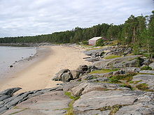
23:
18:
206:The Onega Bay coast was populated by Russians (
178:, the coast and the islands are shared between
8:
164:. From the east, the bay is limited by the
387:Bodies of water of the Republic of Karelia
172:is located close to the shore of the bay.
66:The Onega Bay on the map of the White Sea.
256:
15:
47:
39:
31:
22:
7:
14:
265:"Islands in Onega Bay, White Sea"
168:. In the south-east, the town of
186:of the Republic of Karelia, and
36:Islands in Onega Bay, White Sea
230:Solovetsky Islands are on the
1:
314:(in Russian). Страна Наоборот
92:Онежская губа, Онежский залив
297:. Great Soviet Encyclopedia.
413:
392:Bays of Arkhangelsk Oblast
272:Sites Information Service
149:
91:
56:
382:Bays of the Arctic Ocean
310:
114:, the others being the
397:Ramsar sites in Russia
162:White Sea–Baltic Canal
160:and the outlet of the
106:, west of the city of
79:
67:
377:Bays of the White Sea
245:White Sea Rift System
73:
65:
196:Solovetsky Districts
184:Belomorsky Districts
94:) is located in the
74:Shore of the bay in
344: /
104:Northwestern Russia
96:Republic of Karelia
308:Федосеева, Елена.
142:Solovetsky Islands
100:Arkhangelsk Oblast
80:
68:
49:Reference no.
348:64.333°N 36.500°E
60:
59:
44:13 September 1994
404:
359:
358:
356:
355:
354:
349:
345:
342:
341:
340:
337:
324:
323:
321:
319:
305:
299:
298:
289:
283:
282:
280:
278:
261:
202:Human settlement
176:Administratively
151:
124:Kandalaksha Gulf
93:
16:
412:
411:
407:
406:
405:
403:
402:
401:
362:
361:
352:
350:
346:
343:
338:
335:
333:
331:
330:
328:
327:
317:
315:
312:
307:
306:
302:
291:
290:
286:
276:
274:
263:
262:
258:
253:
241:
228:
204:
166:Onega Peninsula
154:Sumsky Skerries
28:
12:
11:
5:
410:
408:
400:
399:
394:
389:
384:
379:
374:
372:Bays of Russia
364:
363:
353:64.333; 36.500
326:
325:
300:
284:
255:
254:
252:
249:
248:
247:
240:
237:
232:World Heritage
227:
224:
203:
200:
58:
57:
54:
53:
50:
46:
45:
42:
38:
37:
34:
30:
29:
26:Ramsar Wetland
24:
21:
20:
13:
10:
9:
6:
4:
3:
2:
409:
398:
395:
393:
390:
388:
385:
383:
380:
378:
375:
373:
370:
369:
367:
360:
357:
313:
304:
301:
296:
295:
294:Онежская губа
288:
285:
273:
271:
266:
260:
257:
250:
246:
243:
242:
238:
236:
233:
225:
223:
221:
217:
213:
209:
201:
199:
197:
193:
189:
185:
181:
177:
173:
171:
167:
163:
159:
155:
147:
143:
139:
135:
131:
127:
125:
121:
117:
113:
109:
105:
101:
97:
89:
85:
77:
72:
64:
55:
51:
43:
35:
33:Official name
27:
17:
329:
316:. Retrieved
303:
293:
287:
275:. Retrieved
268:
259:
229:
208:Novgorodians
205:
174:
128:
83:
81:
19:Designations
351: /
108:Arkhangelsk
366:Categories
251:References
122:, and the
76:Kiy Island
41:Designated
318:16 August
192:Primorsky
158:Belomorsk
120:Mezen Bay
116:Dvina Bay
112:White Sea
84:Onega Bay
277:25 April
239:See also
188:Onezhsky
339:36°30′E
336:64°20′N
220:Unezhma
216:Purnema
146:Russian
88:Russian
311:Унежма
270:Ramsar
226:Travel
194:, and
180:Kemsky
136:, and
118:, the
170:Onega
130:Onega
320:2011
279:2018
212:selo
182:and
150:луда
98:and
82:The
218:or
138:Vyg
134:Kem
102:in
52:668
368::
267:.
190:,
148::
132:,
90::
322:.
281:.
86:(
78:.
Text is available under the Creative Commons Attribution-ShareAlike License. Additional terms may apply.