86:
777:
618:
102:
838:
109:
516:), running parallel and to the immediate east of the railway line, exiting the suburb as it crosses the Ross River on Rooneys Bridge to Railway Estate. There are three bridge crossings at this point from west to east: the rail bridge, a pedestrian/cycle bridge, and the road bridge.
562:
There are no schools within the suburb. The nearest primary school is
Oonoonba State School, which is within the boundaries of the neighbouring suburb of Idalia. The nearest secondary schools are
429:
469:
134:
535:
Oonoonba State School opened on 15 November 1920. The "old school" was later bulldozed for the new road creating the "new school" the school was opened in 2002 and is still open today.
804:
275:
263:
826:
698:
633:
1106:
85:
408:
The suburb is predominantly a residential area. Oonoonba was once considered isolated from
Townsville, but subdivision development at neighbouring
1176:
1040:
740:
101:
402:
391:
251:
819:
363:
268:
1080:
732:
755:
596:
1416:
1055:
812:
567:
524:
The suburb takes its name from its railway station name, which in turn was named in 1880 using an
Aboriginal word meaning
1045:
563:
127:
23:
1292:
1070:
870:
1327:
1307:
1297:
1131:
1015:
842:
423:
311:
306:
292:
1375:
1141:
965:
1370:
1272:
1221:
1181:
1161:
1151:
975:
970:
960:
880:
1282:
1236:
1101:
1060:
935:
885:
398:
301:
50:
1395:
1390:
1365:
1231:
1216:
1196:
1116:
1005:
1000:
990:
860:
759:
600:
551:
544:
412:
has filled the void between and has made
Oonoonba become part of the contiguous urban area of Townsville.
379:
195:
179:
45:
1385:
1322:
1287:
1251:
1226:
1211:
1206:
1121:
1111:
1030:
1020:
985:
940:
910:
905:
865:
706:
641:
571:
509:
1355:
1332:
1312:
1241:
1186:
1146:
925:
900:
40:
1360:
1302:
1246:
1136:
1126:
1085:
1075:
1025:
1010:
930:
920:
915:
677:
318:
415:
The areas in the north and east of the suburb along the river are not used as they are marshland.
1337:
1317:
1267:
1201:
1166:
1156:
1050:
980:
955:
945:
895:
890:
846:
419:
409:
371:
343:
338:
333:
326:
280:
256:
1171:
950:
875:
736:
213:
793:
1191:
1035:
1380:
1347:
512:(Abbot Street) runs through the suburb from south (Idalia/Cluden where it connects to the
776:
617:
236:
1410:
513:
35:
1277:
1065:
837:
375:
367:
222:
76:
72:
485:
471:
445:
431:
150:
136:
673:
418:
The North Coast railway line passes through the suburb from south (Idalia/
390:
Oonoonba is approximately 5.8 kilometres (3.6 mi) by road south from
242:
699:"Ooonoonba – railway station in the City of Townsville (entry 25485)"
218:
808:
401:, to the east loosely by Gordon Creek, to the south by the
506:) but there is no infrastructure at the station any more.
466:). The suburb is served by the Oonoonba railway station (
634:"Oonoonba – suburb in City of Townsville (entry 44622)"
1346:
1260:
1094:
853:
274:
262:
250:
229:
212:
204:
194:
186:
174:
126:
66:
287:
405:and to the west loosely by Northshore Circuit.
820:
554:, Oonoonba had a population of 2,050 people.
547:, Oonoonba had a population of 1,675 people.
382:, Oonoonba had a population of 2,050 people.
8:
591:
589:
587:
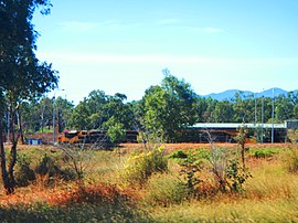
90:Train waiting at a siding in Oonoonba, 2016
61:Suburb of Townsville, Queensland, Australia
827:
813:
805:
775:
727:Queensland Family History Society (2010),
616:
397:The suburb is bounded to the north by the
84:
63:
668:
666:
664:
662:
660:
658:
583:
457:Bridges from Oonoonba to Railway Estate
422:) to north, crossing the Ross River to
628:
626:
331:
316:
299:
289:
7:
392:Townsville central business district
729:Queensland schools past and present
566:to the north in Railway Estate and
241:1,327 km (825 mi) NNW of
14:
733:Queensland Family History Society
208:2.5 km (1.0 sq mi)
836:
108:
107:
100:
756:Australian Bureau of Statistics
597:Australian Bureau of Statistics
568:William Ross State High School
1:
843:Towns, suburbs and localities
235:5.8 km (4 mi) S of
564:Townsville State High School
162:Ooonoonba (centre of suburb)
800:. University of Queensland.
51:GPX (secondary coordinates)
1433:
794:"Oonoonba, Idalia, Cluden"
731:(Version 1.01 ed.),
349:
290:
286:
190:820/km (2,120/sq mi)
95:
83:
46:GPX (primary coordinates)
21:Map all coordinates using
497:Oonoonba railway station
403:North Coast railway line
29:Download coordinates as:
764:2016 Census QuickStats
703:Queensland Place Names
638:Queensland Place Names
605:2021 Census QuickStats
1417:Suburbs of Townsville
707:Queensland Government
642:Queensland Government
510:South Townsville Road
41:GPX (all coordinates)
486:19.3003°S 146.8181°E
446:19.3003°S 146.8181°E
378:, Australia. In the
151:19.2983°S 146.8188°E
678:State of Queensland
481: /
441: /
276:Federal division(s)
264:State electorate(s)
146: /
1056:Thuringowa Central
847:City of Townsville
674:"Queensland Globe"
491:-19.3003; 146.8181
451:-19.3003; 146.8181
372:City of Townsville
257:City of Townsville
156:-19.2983; 146.8188
1404:
1403:
798:Queensland Places
742:978-1-921171-26-0
357:
356:
353:
352:
1424:
1261:Northern Beaches
1046:South Townsville
841:
840:
829:
822:
815:
806:
801:
780:
779:
774:
772:
770:
760:"Oonoonba (SSC)"
758:(27 June 2017).
752:
746:
745:
724:
718:
717:
715:
713:
695:
689:
688:
686:
684:
670:
653:
652:
650:
648:
630:
621:
620:
615:
613:
611:
601:"Oonoonba (SAL)"
599:(28 June 2022).
593:
505:
504:
502:
501:
500:
498:
493:
492:
487:
482:
479:
478:
477:
474:
465:
464:
462:
461:
460:
458:
453:
452:
447:
442:
439:
438:
437:
434:
295:around Oonoonba:
288:
170:
169:
167:
166:
165:
163:
158:
157:
152:
147:
144:
143:
142:
139:
111:
110:
104:
88:
79:
69:
64:
1432:
1431:
1427:
1426:
1425:
1423:
1422:
1421:
1407:
1406:
1405:
1400:
1381:Magnetic Island
1348:Magnetic Island
1342:
1293:Bluewater Beach
1256:
1107:Alligator Creek
1090:
1071:Townsville City
871:Belgian Gardens
849:
835:
833:
792:
789:
784:
783:
768:
766:
754:
753:
749:
743:
726:
725:
721:
711:
709:
697:
696:
692:
682:
680:
672:
671:
656:
646:
644:
632:
631:
624:
609:
607:
595:
594:
585:
580:
560:
541:
522:
496:
494:
490:
488:
484:
483:
480:
475:
472:
470:
468:
467:
456:
454:
450:
448:
444:
443:
440:
435:
432:
430:
428:
427:
388:
187: • Density
161:
159:
155:
153:
149:
148:
145:
140:
137:
135:
133:
132:
122:
121:
120:
119:
118:
117:
116:
112:
91:
71:
70:
67:
62:
59:
58:
57:
56:
55:
12:
11:
5:
1430:
1428:
1420:
1419:
1409:
1408:
1402:
1401:
1399:
1398:
1393:
1388:
1383:
1378:
1373:
1368:
1363:
1358:
1352:
1350:
1344:
1343:
1341:
1340:
1335:
1330:
1328:Saunders Beach
1325:
1320:
1315:
1310:
1308:Bushland Beach
1305:
1300:
1298:Bluewater Park
1295:
1290:
1285:
1280:
1275:
1270:
1264:
1262:
1258:
1257:
1255:
1254:
1249:
1244:
1239:
1234:
1229:
1224:
1219:
1214:
1209:
1204:
1199:
1194:
1189:
1184:
1179:
1174:
1169:
1164:
1159:
1154:
1149:
1144:
1139:
1134:
1132:Cape Cleveland
1129:
1124:
1119:
1114:
1109:
1104:
1098:
1096:
1092:
1091:
1089:
1088:
1083:
1078:
1073:
1068:
1063:
1058:
1053:
1048:
1043:
1038:
1033:
1028:
1023:
1018:
1016:Railway Estate
1013:
1008:
1003:
998:
993:
988:
983:
978:
973:
968:
963:
958:
953:
948:
943:
938:
933:
928:
923:
918:
913:
908:
903:
898:
893:
888:
883:
878:
873:
868:
863:
857:
855:
851:
850:
834:
832:
831:
824:
817:
809:
803:
802:
788:
787:External links
785:
782:
781:
747:
741:
719:
690:
654:
622:
582:
581:
579:
576:
559:
556:
540:
537:
521:
518:
424:Railway Estate
387:
384:
355:
354:
351:
350:
347:
346:
341:
336:
330:
329:
324:
321:
315:
314:
312:Railway Estate
309:
307:Railway Estate
304:
298:
297:
284:
283:
278:
272:
271:
266:
260:
259:
254:
248:
247:
246:
245:
239:
237:Townsville CBD
231:
227:
226:
216:
210:
209:
206:
202:
201:
198:
192:
191:
188:
184:
183:
176:
172:
171:
130:
124:
123:
114:
113:
106:
105:
99:
98:
97:
96:
93:
92:
89:
81:
80:
60:
54:
53:
48:
43:
38:
32:
26:
19:
18:
17:
13:
10:
9:
6:
4:
3:
2:
1429:
1418:
1415:
1414:
1412:
1397:
1394:
1392:
1389:
1387:
1384:
1382:
1379:
1377:
1376:Horseshoe Bay
1374:
1372:
1369:
1367:
1364:
1362:
1359:
1357:
1354:
1353:
1351:
1349:
1345:
1339:
1336:
1334:
1331:
1329:
1326:
1324:
1321:
1319:
1316:
1314:
1311:
1309:
1306:
1304:
1301:
1299:
1296:
1294:
1291:
1289:
1286:
1284:
1281:
1279:
1276:
1274:
1271:
1269:
1266:
1265:
1263:
1259:
1253:
1250:
1248:
1245:
1243:
1240:
1238:
1235:
1233:
1230:
1228:
1225:
1223:
1220:
1218:
1215:
1213:
1210:
1208:
1205:
1203:
1200:
1198:
1195:
1193:
1190:
1188:
1185:
1183:
1180:
1178:
1175:
1173:
1170:
1168:
1165:
1163:
1160:
1158:
1155:
1153:
1150:
1148:
1145:
1143:
1142:Crystal Creek
1140:
1138:
1135:
1133:
1130:
1128:
1125:
1123:
1120:
1118:
1115:
1113:
1110:
1108:
1105:
1103:
1100:
1099:
1097:
1093:
1087:
1084:
1082:
1079:
1077:
1074:
1072:
1069:
1067:
1064:
1062:
1059:
1057:
1054:
1052:
1049:
1047:
1044:
1042:
1039:
1037:
1034:
1032:
1029:
1027:
1024:
1022:
1019:
1017:
1014:
1012:
1009:
1007:
1004:
1002:
999:
997:
994:
992:
989:
987:
984:
982:
979:
977:
974:
972:
969:
967:
966:Mount St John
964:
962:
959:
957:
954:
952:
949:
947:
944:
942:
939:
937:
934:
932:
929:
927:
924:
922:
919:
917:
914:
912:
909:
907:
904:
902:
899:
897:
894:
892:
889:
887:
884:
882:
879:
877:
874:
872:
869:
867:
864:
862:
859:
858:
856:
852:
848:
844:
839:
830:
825:
823:
818:
816:
811:
810:
807:
799:
795:
791:
790:
786:
778:
765:
761:
757:
751:
748:
744:
738:
734:
730:
723:
720:
708:
704:
700:
694:
691:
679:
675:
669:
667:
665:
663:
661:
659:
655:
643:
639:
635:
629:
627:
623:
619:
606:
602:
598:
592:
590:
588:
584:
577:
575:
573:
569:
565:
557:
555:
553:
548:
546:
538:
536:
533:
531:
527:
519:
517:
515:
514:Bruce Highway
511:
507:
503:
463:
425:
421:
416:
413:
411:
406:
404:
400:
395:
393:
385:
383:
381:
377:
373:
369:
365:
361:
348:
345:
342:
340:
337:
335:
332:
328:
325:
322:
320:
317:
313:
310:
308:
305:
303:
300:
296:
294:
285:
282:
279:
277:
273:
270:
267:
265:
261:
258:
255:
253:
249:
244:
240:
238:
234:
233:
232:
228:
224:
220:
217:
215:
211:
207:
203:
199:
197:
193:
189:
185:
181:
177:
173:
168:
131:
129:
125:
103:
94:
87:
82:
78:
74:
65:
52:
49:
47:
44:
42:
39:
37:
34:
33:
31:
30:
25:
24:OpenStreetMap
22:
16:
1371:Florence Bay
1273:Balgal Beach
1222:Rollingstone
1182:Mount Elliot
1177:Majors Creek
1162:Hervey Range
1152:Granite Vale
1041:Shelly Beach
995:
976:Mundingburra
971:Mount Stuart
961:Mount Louisa
881:Bohle Plains
797:
767:. Retrieved
763:
750:
728:
722:
710:. Retrieved
702:
693:
681:. Retrieved
645:. Retrieved
637:
608:. Retrieved
604:
561:
549:
542:
539:Demographics
534:
529:
525:
523:
508:
417:
414:
407:
396:
389:
359:
358:
291:
269:Mundingburra
178:2,050 (
28:
27:
20:
15:
1283:Black River
1237:Rupertswood
1102:Alice River
1061:Town Common
936:Hermit Park
886:Castle Hill
610:28 February
552:2021 census
545:2016 census
489: /
476:146°49′05″E
449: /
436:146°49′05″E
380:2021 census
302:Hermit Park
196:Postcode(s)
180:2021 census
154: /
141:146°49′08″E
128:Coordinates
1396:West Point
1391:Picnic Bay
1366:Cockle Bay
1278:Beach Holm
1232:Ross River
1217:Reid River
1197:Oak Valley
1117:Blue Hills
1066:Townsville
1006:Partington
1001:Pallarenda
991:North Ward
861:Aitkenvale
769:20 October
647:27 January
578:References
530:wet ground
495: (
473:19°18′01″S
455: (
433:19°18′01″S
399:Ross River
376:Queensland
368:Townsville
175:Population
160: (
138:19°17′54″S
77:Queensland
73:Townsville
1386:Nelly Bay
1323:Mount Low
1288:Bluewater
1252:Woodstock
1227:Roseneath
1212:Rangewood
1207:Pinnacles
1122:Brookhill
1112:Barringha
1031:Rowes Bay
1021:Rasmussen
986:Mysterton
941:Hyde Park
911:Currajong
906:Cranbrook
866:Annandale
572:Annandale
558:Education
386:Geography
223:UTC+10:00
214:Time zone
1411:Category
1356:Alma Bay
1333:Toolakea
1313:Deeragun
1242:Toomulla
1187:Mutarnee
1147:Cungulla
1081:West End
996:Oonoonba
926:Gulliver
901:Cosgrove
712:18 April
683:18 April
360:Oonoonba
323:Oonoonba
243:Brisbane
230:Location
115:Oonoonba
68:Oonoonba
1361:Arcadia
1303:Burdell
1247:Toonpan
1137:Clemant
1127:Calcium
1086:Wulguru
1076:Vincent
1026:Rosslea
1011:Pimlico
931:Heatley
921:Garbutt
916:Douglas
845:of the
550:In the
543:In the
520:History
370:in the
319:Rosslea
293:Suburbs
75:,
1338:Yabulu
1318:Jensen
1268:Balgal
1202:Paluma
1167:Julago
1157:Gumlow
1051:Stuart
981:Murray
956:Kirwan
946:Idalia
896:Condon
891:Cluden
739:
420:Cluden
410:Idalia
364:suburb
344:Stuart
339:Cluden
334:Idalia
327:Stuart
281:Dawson
252:LGA(s)
1172:Lynam
1095:Rural
951:Kelso
876:Bohle
854:Urban
526:water
362:is a
1192:Nome
1036:Shaw
771:2018
737:ISBN
714:2020
685:2020
649:2020
612:2023
219:AEST
205:Area
200:4811
570:in
528:or
366:of
36:KML
1413::
796:.
762:.
735:,
705:.
701:.
676:.
657:^
640:.
636:.
625:^
603:.
586:^
574:.
532:.
394:.
374:,
828:e
821:t
814:v
773:.
716:.
687:.
651:.
614:.
499:)
459:)
426:(
225:)
221:(
182:)
164:)
Text is available under the Creative Commons Attribution-ShareAlike License. Additional terms may apply.