813:
46:
702:
61:
73:
124:
332:
The county covers an area of 911.51 square kilometres (351.9 sq mi). As of 2019 its total population is 53,942, out of which the population of Opatów is 6,466, that of Ożarów is 4,569, and the rural population is 42,907.
606:
913:
774:
812:
686:
422:
186:
767:
651:
760:
583:
86:
787:
306:
141:
701:
45:
562:
314:
644:
60:
908:
637:
607:"Population. Size and structure and vital statistics in Poland by territorial division in 2019. As of 30th June"
269:
499:
381:(two urban-rural and six rural). These are listed in the following table, in descending order of population.
350:
136:
832:
887:
862:
72:
877:
872:
741:
548:
206:
736:
716:
691:
527:
506:
443:
201:
191:
171:
882:
867:
847:
837:
362:
358:
354:
857:
342:
294:
752:
721:
464:
176:
902:
842:
731:
569:
366:
346:
196:
827:
726:
485:
181:
541:
520:
457:
326:
251:
101:
88:
672:
436:
318:
151:
478:
383:
801:
783:
322:
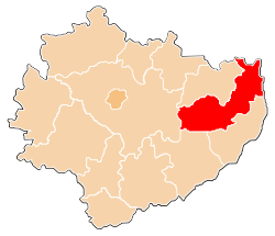
321:, which lies 58 kilometres (36 mi) east of the regional capital
310:
302:
129:
33:
378:
158:
629:
301:) is a unit of territorial administration and local government (
756:
633:
317:
passed in 1998. Its administrative seat and largest town is
313:. It came into being on January 1, 1999, as a result of the
282:
329:, lying 20 km (12 mi) north-east of Opatów.
820:
794:
709:
679:
278:
268:
260:
249:
241:
233:
228:
220:
215:
157:
147:
135:
117:
21:
768:
645:
8:
16:County in Świętokrzyskie Voivodeship, Poland
914:Land counties of Świętokrzyskie Voivodeship
775:
761:
753:
652:
638:
630:
18:
597:
325:. The only other town in the county is
277:
267:
227:
224:911.51 km (351.94 sq mi)
214:
169:
146:
116:
81:
57:
39:
259:
248:
240:
232:
219:
156:
134:
69:
7:
377:The county is subdivided into eight
14:
811:
700:
122:
71:
59:
44:
315:Polish local government reforms
65:Location within the voivodeship
385:
1:
341:Opatów County is bordered by
930:
788:Świętokrzyskie Voivodeship
307:Świętokrzyskie Voivodeship
83:Coordinates (Opatów):
809:
698:
667:
82:
70:
58:
40:
31:
373:Administrative division
365:to the south-west, and
351:Opole Lubelskie County
298:
245:59/km (150/sq mi)
337:Neighbouring counties
102:50.80500°N 21.42472°E
283:http://www.opatow.pl
242: • Density
77:Division into gminas
742:Gmina Wojciechowice
549:Gmina Wojciechowice
353:to the north-east,
207:Gmina Wojciechowice
98: /
680:Urban-rural gminas
261: • Rural
234: • Total
221: • Total
107:50.80500; 21.42472
896:
895:
750:
749:
589:
588:
411:
402:
359:Sandomierz County
288:
287:
921:
815:
777:
770:
763:
754:
704:
654:
647:
640:
631:
621:
620:
618:
617:
602:
409:
400:
384:
343:Ostrowiec County
309:, south-central
299:powiat opatowski
128:
126:
125:
113:
112:
110:
109:
108:
103:
99:
96:
95:
94:
91:
75:
63:
48:
26:Powiat opatowski
19:
929:
928:
924:
923:
922:
920:
919:
918:
899:
898:
897:
892:
816:
807:
790:
781:
751:
746:
717:Gmina Baćkowice
705:
696:
675:
663:
658:
627:
625:
624:
615:
613:
604:
603:
599:
594:
528:Gmina Baćkowice
408:
399:
375:
339:
211:
172:Gmina Baćkowice
168:
167:
123:
121:
106:
104:
100:
97:
92:
89:
87:
85:
84:
78:
66:
54:
53:
52:
51:
36:
27:
24:
17:
12:
11:
5:
927:
925:
917:
916:
911:
901:
900:
894:
893:
891:
890:
885:
880:
875:
870:
865:
860:
855:
850:
845:
840:
835:
830:
824:
822:
818:
817:
810:
808:
806:
805:
798:
796:
792:
791:
782:
780:
779:
772:
765:
757:
748:
747:
745:
744:
739:
734:
729:
724:
722:Gmina Iwaniska
719:
713:
711:
707:
706:
699:
697:
695:
694:
689:
683:
681:
677:
676:
668:
665:
664:
659:
657:
656:
649:
642:
634:
623:
622:
596:
595:
593:
590:
587:
586:
581:
578:
575:
572:
566:
565:
560:
557:
554:
551:
545:
544:
539:
536:
533:
530:
524:
523:
518:
515:
512:
509:
503:
502:
497:
494:
491:
488:
482:
481:
476:
473:
470:
467:
465:Gmina Iwaniska
461:
460:
455:
452:
449:
446:
440:
439:
434:
431:
428:
425:
419:
418:
413:
404:
395:
390:
374:
371:
363:Staszów County
355:Kraśnik County
349:to the north,
338:
335:
286:
285:
280:
276:
275:
272:
266:
265:
262:
258:
257:
254:
247:
246:
243:
239:
238:
235:
231:
230:
226:
225:
222:
218:
217:
213:
212:
210:
209:
204:
199:
194:
189:
184:
179:
177:Gmina Iwaniska
174:
165:
164:
163:
161:
155:
154:
149:
145:
144:
142:Świętokrzyskie
139:
133:
132:
119:
115:
114:
80:
79:
76:
68:
67:
64:
56:
55:
49:
43:
42:
41:
38:
37:
32:
29:
28:
25:
22:
15:
13:
10:
9:
6:
4:
3:
2:
926:
915:
912:
910:
909:Opatów County
907:
906:
904:
889:
886:
884:
881:
879:
876:
874:
871:
869:
866:
864:
861:
859:
856:
854:
851:
849:
846:
844:
841:
839:
836:
834:
831:
829:
826:
825:
823:
821:Land counties
819:
814:
803:
800:
799:
797:
795:City counties
793:
789:
785:
778:
773:
771:
766:
764:
759:
758:
755:
743:
740:
738:
735:
733:
732:Gmina Sadowie
730:
728:
725:
723:
720:
718:
715:
714:
712:
708:
703:
693:
690:
688:
685:
684:
682:
678:
674:
671:
666:
662:
661:Opatów County
655:
650:
648:
643:
641:
636:
635:
632:
628:
612:
608:
601:
598:
591:
585:
582:
579:
576:
573:
571:
570:Gmina Sadowie
568:
567:
564:
563:Wojciechowice
561:
558:
555:
552:
550:
547:
546:
543:
540:
537:
534:
531:
529:
526:
525:
522:
519:
516:
513:
510:
508:
505:
504:
501:
498:
495:
492:
489:
487:
484:
483:
480:
477:
474:
471:
468:
466:
463:
462:
459:
456:
453:
450:
447:
445:
442:
441:
438:
435:
432:
429:
426:
424:
421:
420:
417:
414:
412:
405:
403:
396:
394:
391:
389:
386:
382:
380:
372:
370:
369:to the west.
368:
367:Kielce County
364:
361:to the east,
360:
356:
352:
348:
347:Lipsko County
344:
336:
334:
330:
328:
324:
320:
316:
312:
308:
304:
300:
296:
292:
291:Opatów County
284:
281:
273:
271:
263:
255:
253:
250: •
244:
236:
223:
208:
205:
203:
200:
198:
197:Gmina Sadowie
195:
193:
190:
188:
185:
183:
180:
178:
175:
173:
170:
162:
160:
153:
150:
143:
140:
138:
131:
120:
111:
74:
62:
47:
35:
30:
23:Opatów County
20:
878:Starachowice
852:
737:Gmina Tarłów
727:Gmina Lipnik
710:Rural gminas
692:Gmina Ożarów
687:Gmina Opatów
669:
660:
626:
614:. Retrieved
610:
600:
507:Gmina Tarłów
486:Gmina Lipnik
448:urban-rural
444:Gmina Ożarów
427:urban-rural
423:Gmina Opatów
415:
406:
397:
392:
387:
376:
340:
331:
290:
289:
202:Gmina Tarłów
192:Gmina Ożarów
187:Gmina Opatów
182:Gmina Lipnik
50:Coat of arms
611:stat.gov.pl
137:Voivodeship
105: /
903:Categories
888:Włoszczowa
868:Sandomierz
838:Kazimierza
616:2020-09-14
592:References
407:Population
270:Car plates
229:Population
93:21°25′29″E
90:50°48′18″N
873:Skarżysko
858:Ostrowiec
833:Jędrzejów
804:(capital)
542:Baćkowice
784:Counties
479:Iwaniska
883:Staszów
863:Pińczów
848:Końskie
584:Sadowie
454:10,741
433:11,676
279:Website
166:Total 8
118:Country
853:Opatów
843:Kielce
802:Kielce
673:Opatów
580:3,959
574:rural
559:4,036
553:rural
538:4,874
532:rural
521:Tarłów
517:5,171
514:163.8
511:rural
500:Lipnik
496:5,231
490:rural
475:6,648
472:105.0
469:rural
458:Ożarów
451:183.3
437:Opatów
430:113.4
410:(2019)
379:gminas
327:Ożarów
323:Kielce
319:Opatów
311:Poland
303:powiat
295:Polish
264:42,907
256:11,035
237:53,942
159:Gminas
152:Opatów
130:Poland
127:
34:County
828:Busko
670:Seat:
605:GUS.
577:81.7
556:86.4
535:96.3
493:81.7
401:(km²)
388:Gmina
305:) in
252:Urban
416:Seat
398:Area
393:Type
357:and
345:and
216:Area
148:Seat
786:of
274:TOP
905::
609:.
297::
776:e
769:t
762:v
653:e
646:t
639:v
619:.
293:(
Text is available under the Creative Commons Attribution-ShareAlike License. Additional terms may apply.