119:
126:
200:
37:
220:
212:
409:
Today little can be seen of the collapsed stone wall that once formed the circular rampart. The rampart is around two and a half kilometres long and encloses an area of about 15 hectares. Early scientific assessments indicated it might be of
384:
investigations have taken place for a number of years under the direction of Jochen
Braselmann. Trial digs were carried out and several working ditches, so-called mardelles, were opened. Finds included
515:
Thanks to its views, the
Orensberg is a popular destination for ramblers. It is accessible via a dense network of paths and the route to the top is signed. In addition the hill is a take-off point for
797:
792:
118:
695:
657:
584:
75:
455:) of differing hardness and which bears traces of human activity. This type of feature is common in the Palatine Forest and is locally called a
541:
639:
802:
680:
569:
414:
origin and it was dated to the period around 500 B. C. In the meantime, it has been shown that it is actually the remains of a
492:
496:
475:
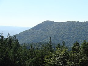
The summit plateau, whose highest point is protected by railings, offers a good all-round view of the
Palatine Forest and the
467:) has been added by human hands. It is not possible to date the workings, but they have been classified to the Celtic period.
762:
68:
479:
to the south. The surrounding area is rich in castles and castle ruins. For example, to the southwest may be seen the
297:
254:
143:
304:, a village 2.8 kilometres to the southeast; the northern slopes of the hill are part of the woods of
199:
723:
542:
Map service of the
Landscape Information System of the Rhineland-Palatinate Nature Conservation Office (
329:
36:
313:
258:
147:
422:
309:
321:
186:
245:
59:
689:
676:
651:
578:
565:
500:
476:
444:
398:
377:
365:
317:
277:
266:
440:
281:
273:
191:
480:
350:
173:
401:. In addition the former entrance in the interior of the circular rampart was uncovered.
308:, a settlement 4.7 km east-southeast. Higher mountains and hills nearby include the
520:
484:
381:
239:
162:
786:
488:
463:("soup bowl"). According to more recent research only the so-called "blood channel" (
418:
390:
219:
614:
305:
766:
618:
415:
301:
250:
211:
139:
560:
Landesamt für
Vermessung und Geobasisinformation Rheinland-Pfalz, ed. (2006),
516:
90:
77:
17:
504:
394:
150:
562:
Topographische Karte 1:25.000 – Neustadt, Maikammer, Edenkoben, Landau
439:("sacrifice or offering bowl") on one of the rocks is a hollow in the
325:
262:
169:
52:
421:, which was built in the 8th century A.D. This evidence came from a
763:"Die Opferschale auf dem Orensberg, ein altes keltisches Heiligtum"
411:
386:
218:
210:
198:
598:
Ernst
Christmann (7 June 1963), "Der Name des Orensbergs",
320:) northeast. Three streams flow past the Orensberg: the
425:
investigation of a piece of an excavated wooden beam.
296:The summit of the Orensberg, which lies within the
185:
180:
161:
106:
67:
51:
46:
29:
265:mountain range that forms the eastern edge of the
747:
745:
380:have been found on the Orensberg. As a result,
537:
535:
300:, rises within the forest estate belonging to
8:
798:Mountains and hills of the Palatinate Forest
793:Mountains and hills of Rhineland-Palatinate
751:Amt für Archäologische Denkmalpflege Speyer
735:
733:
694:: CS1 maint: location missing publisher (
656:: CS1 maint: location missing publisher (
619:"Vortrag "Ausgrabungen auf dem Orensberg""
583:: CS1 maint: location missing publisher (
495:; on the north slope of the Orensberge is
26:
720:Die Pfalz. Deutsche Lande, deutsche Kunst
718:Hans Erich Kubach; Lala Aufsberg (1966),
312:(637.0 m), 2 km north, and the
503:, and to the northwest is the castle of
675:(in German), Ludwigshafen, p. 75,
531:
687:
649:
576:
555:
553:
453:upper rock zone with ball rock horizon
544:Naturschutzverwaltung Rheinland-Pfalz
7:
602:(in German), no. 23, p. 85
376:The remains of settlements from the
345:The Orensberg used to be called the
316:(597.6 m), 2.1 km (both
242:on its summit plateau, is a hill,
234:, also known in the region as the
25:
499:, behind the Roßberg mountain is
125:
124:
117:
35:
487:and its two sister fortresses,
215:Remains of the circular rampart
443:, that has been formed by the
357:, which means "pasture hill" (
1:
640:Landkreis Südliche Weinstraße
349:. This was derived from the
244:581.2 m above
58:581.2 m above
405:Circular rampart or ringwork
272:At the summit is an ancient
722:(in German) (2. ed.),
298:Palatine Forest Nature Park
819:
261:. The hill is part of the
708:Hinweistafel auf dem Berg
389:arrowheads dating to the
111:
34:
257:in the German state of
207:rocks: lookout platform
671:Arndt Hartung (1985),
564:(in German), Koblenz,
519:and a destination for
276:, now designated as a
227:
216:
208:
724:Deutscher Kunstverlag
328:to the south and the
292:Geographical Location
222:
214:
202:
673:Pfälzer Burgenrevier
259:Rhineland-Palatinate
238:due to the striking
148:Rhineland-Palatinate
803:Südliche Weinstraße
646:(in German), Landau
644:Heimatjahrbuch 2007
423:dendrochronological
255:Südliche Weinstraße
144:Südliche Weinstraße
87: /
497:Scharfeneck Castle
459:("water rock") or
253:in the county of
228:
217:
209:
47:Highest point
739:Universität Trier
511:Tourism and sport
501:Meistersel Castle
477:Upper Rhine Plain
399:Early Middle Ages
378:Early Middle Ages
324:to the west, the
318:as the crow flies
278:cultural monument
267:Palatinate Forest
197:
196:
16:(Redirected from
810:
778:
777:
775:
774:
765:. Archived from
758:
752:
749:
740:
737:
728:
727:
715:
709:
706:
700:
699:
693:
685:
668:
662:
661:
655:
647:
636:
630:
629:
627:
626:
610:
604:
603:
595:
589:
588:
582:
574:
557:
548:
539:
447:of rock layers (
441:Bunter sandstone
282:natural monument
274:circular rampart
248:
192:Bunter sandstone
165:
128:
127:
121:
102:
101:
99:
98:
97:
92:
91:49.23°N 8.0275°E
88:
85:
84:
83:
80:
63:(1,907 ft)
62:
39:
27:
21:
818:
817:
813:
812:
811:
809:
808:
807:
783:
782:
781:
772:
770:
761:pfalz-bild.de.
760:
759:
755:
750:
743:
738:
731:
717:
716:
712:
707:
703:
686:
683:
670:
669:
665:
648:
638:
637:
633:
624:
622:
612:
611:
607:
597:
596:
592:
575:
572:
559:
558:
551:
540:
533:
529:
521:mountain bikers
513:
481:imperial castle
473:
433:
407:
374:
362:
351:Old High German
343:
338:
294:
246:sea level (NHN)
243:
240:rock formations
174:Palatine Forest
163:
157:
156:
155:
154:
153:
136:
135:
134:
133:
129:
95:
93:
89:
86:
81:
78:
76:
74:
73:
60:sea level (NHN)
57:
42:
23:
22:
15:
12:
11:
5:
816:
814:
806:
805:
800:
795:
785:
784:
780:
779:
753:
741:
729:
710:
701:
681:
663:
642:, ed. (2007),
631:
621:. Albersweiler
617:(2010-10-24).
605:
590:
570:
549:
530:
528:
525:
512:
509:
472:
469:
461:Suppenschüssel
435:The so-called
432:
427:
406:
403:
382:archaeological
373:
370:
342:
339:
337:
334:
293:
290:
195:
194:
189:
183:
182:
178:
177:
167:
159:
158:
137:
131:
130:
123:
122:
116:
115:
114:
113:
112:
109:
108:
104:
103:
71:
65:
64:
55:
49:
48:
44:
43:
40:
32:
31:
24:
14:
13:
10:
9:
6:
4:
3:
2:
815:
804:
801:
799:
796:
794:
791:
790:
788:
769:on 2011-05-14
768:
764:
757:
754:
748:
746:
742:
736:
734:
730:
725:
721:
714:
711:
705:
702:
697:
691:
684:
682:3-9801043-3-8
678:
674:
667:
664:
659:
653:
645:
641:
635:
632:
620:
616:
613:Ortsgemeinde
609:
606:
601:
594:
591:
586:
580:
573:
571:3-89637-285-8
567:
563:
556:
554:
550:
547:
545:
538:
536:
532:
526:
524:
522:
518:
510:
508:
506:
502:
498:
494:
490:
486:
482:
478:
470:
468:
466:
462:
458:
454:
450:
449:Karlstal beds
446:
442:
438:
431:
428:
426:
424:
420:
419:refuge castle
417:
413:
404:
402:
400:
396:
393:, as well as
392:
391:New Stone Age
388:
383:
379:
371:
369:
368:
367:
360:
356:
352:
348:
340:
335:
333:
332:to the east.
331:
327:
323:
319:
315:
311:
307:
303:
299:
291:
289:
287:
283:
279:
275:
270:
268:
264:
260:
256:
252:
247:
241:
237:
236:Orensfels(en)
233:
226:
221:
213:
206:
201:
193:
190:
188:
184:
179:
175:
171:
168:
166:
160:
152:
149:
145:
141:
120:
110:
105:
100:
96:49.23; 8.0275
72:
70:
66:
61:
56:
54:
50:
45:
41:The Orensberg
38:
33:
28:
19:
771:. Retrieved
767:the original
756:
726:, p. 26
719:
713:
704:
672:
666:
643:
634:
623:. Retrieved
615:Albersweiler
608:
599:
593:
561:
543:
514:
493:Scharfenberg
474:
464:
460:
456:
452:
448:
436:
434:
429:
408:
375:
363:
358:
354:
346:
344:
295:
285:
271:
235:
231:
229:
224:
204:
187:Type of rock
164:Parent range
517:paragliders
457:Wasserstein
437:Opferschale
430:Opferschale
416:Carolingian
372:Excavations
314:Teufelsberg
302:Frankweiler
286:Orensfelsen
251:Frankweiler
225:Opferschale
205:Orensfelsen
140:Frankweiler
94: /
69:Coordinates
787:Categories
773:2012-01-12
625:2010-11-16
600:Wasgaubote
527:References
280:, and the
79:49°13′48″N
465:Blutrinne
397:from the
364:see also
359:Weideberg
347:Urlesberg
306:Böchingen
232:Orensberg
132:Orensberg
107:Geography
82:8°01′39″E
53:Elevation
30:Orensberg
18:Orensfels
690:citation
652:citation
579:citation
366:Urnsburg
330:Hainbach
322:Dernbach
505:Ramburg
485:Trifels
445:erosion
395:pottery
336:History
310:Roßberg
288:rocks.
284:of the
249:, near
181:Geology
151:Germany
679:
568:
489:Anebos
471:Sights
412:Celtic
326:Queich
263:Haardt
170:Haardt
387:flint
355:Urlaß
353:word
138:near
696:link
677:ISBN
658:link
585:link
566:ISBN
491:and
341:Name
230:The
223:The
203:The
483:of
789::
744:^
732:^
692:}}
688:{{
654:}}
650:{{
581:}}
577:{{
552:^
534:^
523:.
507:.
451:,
269:.
146:,
142:;
776:.
698:)
660:)
628:.
587:)
546:)
361:.
176:)
172:(
20:)
Text is available under the Creative Commons Attribution-ShareAlike License. Additional terms may apply.