373:
361:
325:
337:
349:
29:
75:
66:
304:
US agents patrol the lake, which straddles the border. Boaters can cross the border but cannot land or contact anyone without having reported to the
Customs and Border Protection office. In 2003, two Canadians were apprehended after crossing under the cover of darkness in an 18-foot canoe loaded with
253:
Administrative oversight transferred from the Port of
Victoria to the Port of New Westminster in 1880 and to the Port of Grand Forks in 1899. The office closed in 1902 but reopened in 1905. Oversight passed to the Port of Greenwood in 1907 and the Port of Penticton in 1924. The status was upgraded to
301:. On at least one occasion, officers mistakenly believed the smugglers had crossed to the US side. Consequently, the arrested individuals were released without charge at dawn. The customs building location changed several times before erection at the present site.
572:
293:
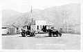
ran south of the border for a brief span near
Oroville, but this section was soon decommissioned and a new section blazed north of the border. That decade, a rudimentary building housed the US Customs office.
665:
608:
670:
650:
660:
119:
389:
655:
250:
within months. The building was physically moved to the village of
Osoyoos in 1865. After the structure burned down in 1878, Haynes operated out of his residence.
372:
509:
360:
348:
336:
324:
527:
491:
More lightning in the hand : a case study of the security vulnerabilities of the
Osoyoos Port of Entry at the Canada-US Boundary Line
298:
216:
258:
274:
A 2015 thesis examining the security vulnerabilities of the
Osoyoos Port of Entry lacks informative summary conclusions.
112:
224:
78:
69:
590:
212:
631:
440:
239:
470:
208:
297:
The
Oroville border patrol station, established in 1929, actively pursued liquor smugglers during
195:
192:
489:
278:
243:
281:
restrictions tied up traffic on
Highway 97 and into Osoyoos before heading to the border.
28:
644:
290:
271:
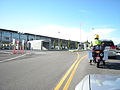
million joint border inspection station which houses the agencies of both countries.
220:
47:
242:
was the inaugural customs officer 1861–1888 until his death. Initially on the lower
247:
89:
33:
Aerial view of the US-Canada joint border station in 2010. Canada is to the right.
101:
134:
121:
246:, the customs office relocated to the west shore at the north end of
51:
305:
478 pounds of marijuana. In 2021, officers discovered and seized
441:"Okanagan Historical Society, 1935: Early Days at Osoyoos"
235:
The first cattle drive crossing at
Osoyoos was in 1858.
666:
Buildings and structures in
Okanogan County, Washington
528:"The Place Where We Live: Looking Back To Look Forward"
633:
The story of Osoyoos, September 1811 to December 1952
609:"CBP: Canadian Woman Arrested for Currency Smuggling"
313:
in unreported currency during a vehicle inspection.
16:
Border crossing between Canada and the United States
179:
171:
163:
155:
150:
111:
57:
43:
38:
21:
277:In 2022, protesting truck drivers seeking to end
238:One of the earliest border inspection locations,
671:Transportation in Okanogan County, Washington
426:Customs Services in Western Canada, 1867–1925
390:List of Canada–United States border crossings
378:Canada border crossing at Osoyoos, BC, c.2003
354:Canadian border station at Osoyoos, BC, 1997.
8:
330:Canadian border station at Osoyoos, BC, 1922
428:. The Creston Review Ltd. pp. 200–202.
342:Oroville-Osoyoos border survey marker, 2015
366:US border station at Oroville, WA, c.1990s
261:border patrol was established at Osoyoos.
18:
661:1929 establishments in Washington (state)
656:1861 establishments in British Columbia
401:
320:
264:In 2003, the US and Canada completed a
559:
547:
457:
419:
417:
408:
651:Canada–United States border crossings
7:
14:
371:
359:
347:
335:
323:
299:Prohibition in the United States
205:Oroville–Osoyoos Border Crossing
73:
64:
27:
22:Oroville–Osoyoos Border Crossing
636:– via www.library.ubc.ca.
289:During the 1860s, the original
1:
56:
514:www.similkameenspotlight.com
439:Kruger, Chrestenza (1936).
225:British Columbia Highway 97
223:on the American side joins
687:
254:Port of Osoyoos in 1948.
213:Osoyoos, British Columbia
187:
26:
630:Fraser, Geo. J. (1952).
135:49.000084°N 119.461757°W
573:"CBP: Oroville Station"
535:www.streamkeepers.bc.ca
510:"Similkameen Spotlight"
496:www.open.library.ubc.ca
488:McCroy, Amy J. (2015).
424:Legg, Herbert (1962).
240:John Carmichael Haynes
227:on the Canadian side.
140:49.000084; -119.461757
460:, p. 201, (199).
207:connects the city of
562:, p. 169 (167).
550:, p. 116 (114).
411:, p. 195 (193).
209:Oroville, Washington
131: /
537:. p. 32 (24).
445:www.library.ubc.ca
279:COVID-19 pandemic
244:Similkameen River
201:
200:
100:202 97th Street,
678:
637:
617:
616:
605:
599:
598:
587:
581:
580:
569:
563:
557:
551:
545:
539:
538:
532:
524:
518:
517:
506:
500:
499:
485:
479:
478:
467:
461:
455:
449:
448:
436:
430:
429:
421:
412:
406:
375:
363:
351:
339:
327:
312:
308:
270:
267:
217:Canada–US border
211:and the town of
146:
145:
143:
142:
141:
136:
132:
129:
128:
127:
124:
77:
76:
68:
67:
31:
19:
686:
685:
681:
680:
679:
677:
676:
675:
641:
640:
629:
626:
621:
620:
607:
606:
602:
589:
588:
584:
571:
570:
566:
558:
554:
546:
542:
530:
526:
525:
521:
508:
507:
503:
487:
486:
482:
469:
468:
464:
456:
452:
438:
437:
433:
423:
422:
415:
407:
403:
398:
386:
379:
376:
367:
364:
355:
352:
343:
340:
331:
328:
319:
310:
306:
287:
268:
265:
233:
191:
139:
137:
133:
130:
125:
122:
120:
118:
117:
107:
79:Highway 97
74:
65:
34:
17:
12:
11:
5:
684:
682:
674:
673:
668:
663:
658:
653:
643:
642:
639:
638:
625:
622:
619:
618:
615:. 20 Jul 2010.
600:
597:. 18 Aug 2013.
582:
579:. 24 Mar 2017.
564:
552:
540:
519:
516:. 22 Feb 2022.
501:
480:
477:. 10 Oct 2003.
462:
450:
431:
413:
400:
399:
397:
394:
393:
392:
385:
382:
381:
380:
377:
370:
368:
365:
358:
356:
353:
346:
344:
341:
334:
332:
329:
322:
318:
315:
286:
283:
232:
229:
199:
198:
185:
184:
181:
177:
176:
175:1-800-461-9999
173:
169:
168:
167:(509) 476-2955
165:
161:
160:
157:
153:
152:
148:
147:
115:
109:
108:
106:
105:
97:Canadian Port:
93:
88:33643 Hwy 97,
81:
61:
59:
55:
54:
45:
41:
40:
36:
35:
32:
24:
23:
15:
13:
10:
9:
6:
4:
3:
2:
683:
672:
669:
667:
664:
662:
659:
657:
654:
652:
649:
648:
646:
635:
634:
628:
627:
623:
614:
610:
604:
601:
596:
592:
586:
583:
578:
574:
568:
565:
561:
556:
553:
549:
544:
541:
536:
529:
523:
520:
515:
511:
505:
502:
497:
493:
492:
484:
481:
476:
472:
466:
463:
459:
454:
451:
446:
442:
435:
432:
427:
420:
418:
414:
410:
405:
402:
395:
391:
388:
387:
383:
374:
369:
362:
357:
350:
345:
338:
333:
326:
321:
316:
314:
302:
300:
295:
292:
291:Dewdney Trail
284:
282:
280:
275:
272:
262:
260:
255:
251:
249:
245:
241:
236:
231:Canadian side
230:
228:
226:
222:
221:U.S. Route 97
218:
214:
210:
206:
197:
194:
190:
186:
182:
178:
174:
170:
166:
162:
158:
154:
149:
144:
116:
114:
110:
103:
99:
98:
94:
91:
87:
86:
82:
80:
71:
63:
62:
60:
53:
49:
48:United States
46:
42:
37:
30:
25:
20:
632:
612:
603:
595:komonews.com
594:
585:
576:
567:
555:
543:
534:
522:
513:
504:
495:
490:
483:
474:
465:
453:
444:
434:
425:
404:
303:
296:
288:
276:
273:
263:
257:In 1940, an
256:
252:
248:Osoyoos Lake
237:
234:
204:
202:
188:
96:
95:
90:Oroville, WA
84:
83:
613:www.cbp.gov
591:"Komo News"
577:www.cbp.gov
560:Fraser 1952
548:Fraser 1952
475:www.cscb.ca
471:"CSCB News"
458:Fraser 1952
409:Fraser 1952
307:US$ 132,980
138: /
126:119°27′42″W
113:Coordinates
102:Osoyoos, BC
645:Categories
624:References
447:: 87 (77).
311:CA$ 12,200
123:49°00′00″N
70:US 97
396:Footnotes
172:Can Phone
384:See also
196:Canadian
183:24 hours
164:US Phone
85:US Port:
72: /
58:Location
39:Location
317:Gallery
285:US side
215:on the
189:Website
151:Details
104:V0H 1V1
44:Country
269:
266:US$ 31
156:Opened
52:Canada
531:(PDF)
498:(MA).
180:Hours
92:98844
309:and
259:RCMP
203:The
159:1861
647::
611:.
593:.
575:.
533:.
512:.
494:.
473:.
443:.
416:^
219:.
193:US
50:;
Text is available under the Creative Commons Attribution-ShareAlike License. Additional terms may apply.