590:
38:
527:
387:
27:
259:
244:
122:
131:
759:
369:
To the east of
Cleobury Mortimer there are junctions with the B4202 road (which heads southwards into north Worcestershire), and the B4201 and B4363 roads (which head northwards into east Shropshire). Further along, the B4214 road runs from a junction with the A4117 at Cleehill, down a considerable
534:
The A4117 was created in 1927. Previously the majority of the route (from Henley to
Fingerpost) was the B4200, and the remainder (between the A49 in Ludlow and Henley) was part of the B4364. (These B roads having been classified only five years earlier in 1922.) The route number 'B4200' has since
557:
This 1.0 mile (1.6 km) section from the pre-bypass A49 route (which has been re-classified as the B4361) along New Road and Henley Road to the Rocks Green roundabout is no longer a classified (A or B) route, however remains a busy local route (and the 292 bus route runs the length of Henley
601:
and mileposts (dated to the 18th and 19th centuries) continue to exist along the route; the remaining ones are in place between Far Forest and
Cleobury Mortimer (marking distances to Cleobury and Bewdley) and again from Doddington to Henley (marking distances to Ludlow and Cleobury).
574:, which finally closed in 1960, near to the former Cleobury Mortimer railway station, which was situated some distance from the town in the Wyre Forest and which was the junction of these two lines. The town, since these closures, has no railway links.
477:
Due to the hilly terrain and passing through the constrained streets through
Cleobury Mortimer and Clee Hill Village, it is sometimes quicker (and more fuel efficient, especially for heavy goods vehicles) to take the A456 and A49 (i.e. via
517:
supermarket was constructed at the junction with the A49 in 2021 and originally an adjacent filling station was planned, but due to no interest from potential operators, as of 2024 there is a plan for a Costa Drive-thru instead.
693:
1846:
510:, at Mawley Oak (the B4202 junction), in Cleobury Mortimer, and at Foxwood near Doddington. Another opened in 2017 at the original junction with the former route of the A49 in Ludlow.
1462:
1457:
571:
366:
The A4117 has no 'A road' junctions other than at its two ends. It has five junctions with 'B roads' however, all of which are at a terminus of the B road in question.
542:
Prior to the opening of the A49 Ludlow bypass in 1979, the A4117 continued into the town along Henley Road and New Road to the old A49 route (passing under the
581:
in Ludlow to the stone aggregate quarries on Clee Hill, meaning the quarrying operations there (which continue to the present-day) now rely on the A4117 road.
530:
The
Cornbrook Corner, between Doddington and Clee Hill Village; above can be seen quarrying operations, which use the A4117 for transporting extracted stone.
417:
Two notable inclines are named – the stretch from Hopton Wafers to
Doddington is Hopton Bank; whilst the road from Clee Hill Village down to Henley is named
648:
1841:
738:
589:
1861:
678:
222:
1856:
1851:
402:
reaches an altitude of 381 metres (1,250 ft), making the A4117 Shropshire's highest A-road (the highest classified road is the B4368 at
425:(a sand trap for vehicles unable to brake) towards its lower end in Hopton Wafers; this was however removed in 2014 having become obsolete.
1662:
1495:
227:
1825:
748:
550:
in the 1950s diverted the A49, after which the A4117 ran a little further (along part of the former A49 route), crossing the historic
1944:
1881:
482:) instead, if travelling between Bewdley and Ludlow; these two A roads are designated primary routes, whilst the A4117 is not.
1505:
731:
1866:
1836:
1831:
59:
1939:
1876:
1816:
851:
567:
214:
37:
546:
at the foot of New Road). The junction with the A49 was at the Bridge Inn on Corve Street until the construction of
1871:
1324:
316:
262:
247:
104:
1934:
831:
724:
125:
1488:
1374:
716:
280:
134:
1895:
327:
it passes over the Lem Brook and into
Shropshire. Heading in a roughly westerly direction, it passes through
1724:
1339:
433:
1785:
1684:
1654:
1643:
526:
443:
There is a public car park by the A4117 in Clee Hill
Village, which affords a considerable view over the
1821:
1806:
1744:
1709:
1584:
1526:
1434:
666:
495:
411:
399:
351:
386:
1633:
1604:
1481:
456:
1801:
1531:
1184:
783:
578:
543:
403:
54:
1549:
498:, runs along the entire length of the road, providing regular public buses Monday to Saturday.
1811:
1569:
768:
471:
467:
328:
1780:
1775:
1770:
1319:
390:
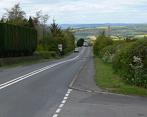
The A4117 just east of
Cleehill, where the road passes through a common with grazing sheep.
1949:
1564:
636:
507:
354:
on the eastern edge of
Cleobury Mortimer, the Hopton Brook at Hopton Wafers, and also the
1694:
1594:
514:
355:
320:
188:
171:
697:
Drive-thru Costa planned after supermarket site attracts no interest as petrol station
1928:
1719:
1444:
547:
491:
448:
395:
371:
332:
1749:
1729:
1679:
1599:
1169:
1473:
1754:
1704:
1689:
1579:
1149:
551:
463:
437:
429:
422:
292:
1739:
1734:
1699:
1638:
1619:
1554:
1511:
1439:
1424:
1419:
1414:
1409:
1404:
1399:
1394:
1389:
1384:
1379:
1364:
1359:
1354:
1349:
1344:
1334:
1329:
1314:
1309:
1304:
1299:
1294:
1289:
1284:
1279:
1269:
1264:
1259:
1254:
1249:
1244:
1239:
1234:
1229:
1224:
1219:
1214:
1209:
1204:
1199:
1194:
1189:
1179:
1174:
1164:
1159:
1154:
1144:
536:
479:
444:
375:
324:
296:
288:
1910:
1897:
1714:
1429:
1369:
1131:
1126:
1121:
1116:
1111:
1106:
1101:
1096:
1091:
1086:
1081:
1076:
1071:
1066:
1061:
1056:
1051:
1046:
1041:
1036:
1031:
1026:
1021:
1016:
1011:
1006:
1001:
996:
991:
986:
981:
976:
971:
966:
961:
956:
951:
946:
941:
936:
931:
926:
921:
916:
911:
906:
901:
896:
891:
886:
881:
876:
871:
866:
861:
856:
846:
841:
836:
598:
452:
418:
308:
100:
652:
Shropshire motorists put faith in brakes as escape lane reaches end of road
26:
1609:
1559:
818:
813:
808:
803:
798:
793:
788:
778:
773:
406:). Because of its situation and altitude, the A4117 is often affected by
344:
336:
144:
1624:
1614:
758:
312:
284:
181:
108:
1628:
1589:
621:
340:
151:
440:
across the road to keep the openly grazing sheep within the common.
570:, which closed in 1962 to passengers and 1964 for freight, and the
708:
588:
525:
385:
343:, where (since 1979) it ends at the Rocks Green roundabout on the
1574:
407:
1477:
720:
1649:
323:, as immediately after passing through the small village of
319:. Only the first 1.2 miles (1.9 km) of the route is in
462:
The road also passes right through the centre of the small
374:. At Henley, near the Ludlow bypass, the B4364 road from
421:. Hopton Bank had Shropshire's last remaining emergency
410:
in winter. This upland part of the route is within the
347:
bypass. The route is 15.0 miles (24.1 km) long.
577:
1962 saw the final closure of the railway link from
1794:
1763:
1672:
1540:
1519:
205:
187:
177:
167:
162:
140:
114:
96:
91:
81:
73:
65:
47:
23:
572:Cleobury Mortimer and Ditton Priors Light Railway
474:along the road. This stretch is often congested.
350:Notable bridges are where the road crosses the
447:valley below and further into the counties of
87:1979 shortened by 1.0 mile (1.6 km) miles
1489:
732:
8:
593:One of the historic mileposts on the route.
1496:
1482:
1474:
739:
725:
717:
632:
630:
236:
451:and Worcestershire. At the car park is a
617:
615:
339:. The road's destination is the town of
611:
436:and Clee Hill Village, and as such has
682:New supermarket taking shape in Ludlow
506:The modern route as of 2018 has three
20:
662:
660:
7:
1663:List of civil parishes in Shropshire
490:The 292 bus service (Ludlow-Bewdley-
749:Great Britain road numbering scheme
291:, which passes through part of the
14:
535:been re-used for a short road in
757:
311:2.2 miles (3.5 km) west of
257:
242:
129:
120:
69:15.0 mi (24.1 km)
36:
25:
85:1922–27 classified as the B4200
1:
60:Worcestershire County Council
1842:Parliamentary constituencies
709:Milestone Society Repository
398:over the southern slopes of
568:Tenbury and Bewdley Railway
566:The A4117 passed under the
215:Roads in the United Kingdom
1966:
1862:Grade II* listed buildings
544:Welsh Marches railway line
1463:List of B roads in Zone 4
1458:List of A roads in Zone 4
1453:
1140:
827:
764:
755:
747:A roads in Zone 4 of the
279:is a single-carriageway '
235:
210:
201:
158:
52:
35:
1857:Grade I listed buildings
428:The road passes through
1945:Roads in Worcestershire
358:at Henley near Ludlow.
1786:Shropshire Union Canal
594:
531:
391:
597:A number of historic
592:
529:
412:Shropshire Hills AONB
400:Titterstone Clee Hill
389:
307:It branches from the
315:, at a place called
1940:Roads in Shropshire
1907: /
1543:(cities in italics)
1520:Unitary authorities
457:public conveniences
178:Constituent country
116:Major intersections
42:A4117 at Angel Bank
1532:Telford and Wrekin
595:
579:Clee Hill Junction
532:
392:
228:A and B road zones
55:Shropshire Council
16:Road in Shropshire
1890:
1889:
1812:Shrewsbury floods
1570:Cleobury Mortimer
1541:Major settlements
1506:Ceremonial county
1471:
1470:
472:linear settlement
468:Cleobury Mortimer
455:and close by are
378:joins the A4117.
337:Clee Hill Village
329:Cleobury Mortimer
273:
272:
269:
268:
48:Route information
1957:
1935:Roads in England
1922:
1921:
1919:
1918:
1917:
1912:
1908:
1905:
1904:
1903:
1900:
1867:Lord Lieutenants
1781:Shrewsbury Canal
1776:Montgomery Canal
1771:Llangollen Canal
1514:
1508:
1498:
1491:
1484:
1475:
761:
741:
734:
727:
718:
711:
706:
700:
691:
685:
676:
670:
664:
655:
646:
640:
634:
625:
619:
562:Railway closures
508:filling stations
362:B road junctions
265:
261:
260:
250:
246:
245:
237:
133:
132:
124:
123:
117:
40:
29:
21:
1965:
1964:
1960:
1959:
1958:
1956:
1955:
1954:
1925:
1924:
1915:
1913:
1911:52.384°N 2.54°W
1909:
1906:
1901:
1898:
1896:
1894:
1893:
1891:
1886:
1790:
1759:
1668:
1657:
1565:Church Stretton
1550:Bishop's Castle
1542:
1536:
1515:
1510:
1504:
1502:
1472:
1467:
1449:
1136:
823:
762:
751:
745:
715:
714:
707:
703:
699:(31 March 2024)
694:Shropshire Star
692:
688:
679:Shropshire Star
677:
673:
665:
658:
649:Shropshire Star
647:
643:
637:Ordnance Survey
635:
628:
620:
613:
608:
587:
564:
524:
504:
488:
384:
364:
305:
258:
256:
243:
241:
190:
130:
128:
121:
115:
92:Major junctions
86:
58:
43:
30:
17:
12:
11:
5:
1963:
1961:
1953:
1952:
1947:
1942:
1937:
1927:
1926:
1888:
1887:
1885:
1884:
1879:
1877:Rail transport
1874:
1869:
1864:
1859:
1854:
1852:Country houses
1849:
1844:
1839:
1834:
1829:
1819:
1814:
1809:
1804:
1798:
1796:
1792:
1791:
1789:
1788:
1783:
1778:
1773:
1767:
1765:
1761:
1760:
1758:
1757:
1752:
1747:
1742:
1737:
1732:
1727:
1722:
1717:
1712:
1707:
1702:
1697:
1692:
1687:
1682:
1676:
1674:
1670:
1669:
1667:
1666:
1652:
1647:
1641:
1636:
1631:
1622:
1617:
1612:
1607:
1602:
1597:
1595:Market Drayton
1592:
1587:
1582:
1577:
1572:
1567:
1562:
1557:
1552:
1546:
1544:
1538:
1537:
1535:
1534:
1529:
1523:
1521:
1517:
1516:
1503:
1501:
1500:
1493:
1486:
1478:
1469:
1468:
1466:
1465:
1460:
1454:
1451:
1450:
1448:
1447:
1442:
1437:
1432:
1427:
1422:
1417:
1412:
1407:
1402:
1397:
1392:
1387:
1382:
1377:
1372:
1367:
1362:
1357:
1352:
1347:
1342:
1337:
1332:
1327:
1322:
1317:
1312:
1307:
1302:
1297:
1292:
1287:
1282:
1277:
1272:
1267:
1262:
1257:
1252:
1247:
1242:
1237:
1232:
1227:
1222:
1217:
1212:
1207:
1202:
1197:
1192:
1187:
1182:
1177:
1172:
1167:
1162:
1157:
1152:
1147:
1141:
1138:
1137:
1135:
1134:
1129:
1124:
1119:
1114:
1109:
1104:
1099:
1094:
1089:
1084:
1079:
1074:
1069:
1064:
1059:
1054:
1049:
1044:
1039:
1034:
1029:
1024:
1019:
1014:
1009:
1004:
999:
994:
989:
984:
979:
974:
969:
964:
959:
954:
949:
944:
939:
934:
929:
924:
919:
914:
909:
904:
899:
894:
889:
884:
879:
874:
869:
864:
859:
854:
849:
844:
839:
834:
828:
825:
824:
822:
821:
816:
811:
806:
801:
796:
791:
786:
781:
776:
771:
765:
763:
756:
753:
752:
746:
744:
743:
736:
729:
721:
713:
712:
701:
686:
671:
656:
641:
626:
610:
609:
607:
604:
586:
583:
563:
560:
523:
520:
503:
500:
494:) operated by
487:
484:
383:
380:
363:
360:
356:Ledwyche Brook
321:Worcestershire
304:
301:
271:
270:
267:
266:
253:
251:
233:
232:
231:
230:
225:
219:
218:
208:
207:
203:
202:
199:
198:
193:
185:
184:
179:
175:
174:
172:United Kingdom
169:
165:
164:
160:
159:
156:
155:
142:
138:
137:
118:
112:
111:
98:
94:
93:
89:
88:
83:
79:
78:
75:
71:
70:
67:
63:
62:
53:Maintained by
50:
49:
45:
44:
41:
33:
32:
24:
15:
13:
10:
9:
6:
4:
3:
2:
1962:
1951:
1948:
1946:
1943:
1941:
1938:
1936:
1933:
1932:
1930:
1923:
1920:
1916:52.384; -2.54
1883:
1880:
1878:
1875:
1873:
1872:High Sheriffs
1870:
1868:
1865:
1863:
1860:
1858:
1855:
1853:
1850:
1848:
1845:
1843:
1840:
1838:
1835:
1833:
1830:
1827:
1823:
1820:
1818:
1815:
1813:
1810:
1808:
1805:
1803:
1800:
1799:
1797:
1793:
1787:
1784:
1782:
1779:
1777:
1774:
1772:
1769:
1768:
1766:
1762:
1756:
1753:
1751:
1748:
1746:
1743:
1741:
1738:
1736:
1733:
1731:
1728:
1726:
1723:
1721:
1718:
1716:
1713:
1711:
1708:
1706:
1703:
1701:
1698:
1696:
1693:
1691:
1688:
1686:
1683:
1681:
1678:
1677:
1675:
1671:
1665:
1664:
1660:
1656:
1653:
1651:
1648:
1645:
1642:
1640:
1637:
1635:
1632:
1630:
1626:
1623:
1621:
1618:
1616:
1613:
1611:
1608:
1606:
1603:
1601:
1598:
1596:
1593:
1591:
1588:
1586:
1583:
1581:
1578:
1576:
1573:
1571:
1568:
1566:
1563:
1561:
1558:
1556:
1553:
1551:
1548:
1547:
1545:
1539:
1533:
1530:
1528:
1525:
1524:
1522:
1518:
1513:
1507:
1499:
1494:
1492:
1487:
1485:
1480:
1479:
1476:
1464:
1461:
1459:
1456:
1455:
1452:
1446:
1443:
1441:
1438:
1436:
1433:
1431:
1428:
1426:
1423:
1421:
1418:
1416:
1413:
1411:
1408:
1406:
1403:
1401:
1398:
1396:
1393:
1391:
1388:
1386:
1383:
1381:
1378:
1376:
1373:
1371:
1368:
1366:
1363:
1361:
1358:
1356:
1353:
1351:
1348:
1346:
1343:
1341:
1338:
1336:
1333:
1331:
1328:
1326:
1323:
1321:
1318:
1316:
1313:
1311:
1308:
1306:
1303:
1301:
1298:
1296:
1293:
1291:
1288:
1286:
1283:
1281:
1278:
1276:
1273:
1271:
1268:
1266:
1263:
1261:
1258:
1256:
1253:
1251:
1248:
1246:
1243:
1241:
1238:
1236:
1233:
1231:
1228:
1226:
1223:
1221:
1218:
1216:
1213:
1211:
1208:
1206:
1203:
1201:
1198:
1196:
1193:
1191:
1188:
1186:
1183:
1181:
1178:
1176:
1173:
1171:
1168:
1166:
1163:
1161:
1158:
1156:
1153:
1151:
1148:
1146:
1143:
1142:
1139:
1133:
1130:
1128:
1125:
1123:
1120:
1118:
1115:
1113:
1110:
1108:
1105:
1103:
1100:
1098:
1095:
1093:
1090:
1088:
1085:
1083:
1080:
1078:
1075:
1073:
1070:
1068:
1065:
1063:
1060:
1058:
1055:
1053:
1050:
1048:
1045:
1043:
1040:
1038:
1035:
1033:
1030:
1028:
1025:
1023:
1020:
1018:
1015:
1013:
1010:
1008:
1005:
1003:
1000:
998:
995:
993:
990:
988:
985:
983:
980:
978:
975:
973:
970:
968:
965:
963:
960:
958:
955:
953:
950:
948:
945:
943:
940:
938:
935:
933:
930:
928:
925:
923:
920:
918:
915:
913:
910:
908:
905:
903:
900:
898:
895:
893:
890:
888:
885:
883:
880:
878:
875:
873:
870:
868:
865:
863:
860:
858:
855:
853:
850:
848:
845:
843:
840:
838:
835:
833:
830:
829:
826:
820:
817:
815:
812:
810:
807:
805:
802:
800:
797:
795:
792:
790:
787:
785:
782:
780:
777:
775:
772:
770:
767:
766:
760:
754:
750:
742:
737:
735:
730:
728:
723:
722:
719:
710:
705:
702:
698:
695:
690:
687:
684:(1 June 2021)
683:
680:
675:
672:
668:
663:
661:
657:
654:(21 May 2014)
653:
650:
645:
642:
638:
633:
631:
627:
623:
618:
616:
612:
605:
603:
600:
591:
584:
582:
580:
575:
573:
569:
561:
559:
555:
553:
549:
548:Burway Bridge
545:
540:
538:
528:
521:
519:
516:
511:
509:
501:
499:
497:
493:
492:Kidderminster
485:
483:
481:
475:
473:
470:, which is a
469:
465:
460:
458:
454:
450:
449:Herefordshire
446:
441:
439:
435:
431:
426:
424:
420:
415:
413:
409:
405:
401:
397:
388:
381:
379:
377:
373:
372:Tenbury Wells
367:
361:
359:
357:
353:
348:
346:
342:
338:
334:
333:Hopton Wafers
330:
326:
322:
318:
314:
310:
302:
300:
298:
294:
290:
287:, largely in
286:
283:' in western
282:
278:
264:
254:
252:
249:
239:
238:
234:
229:
226:
224:
221:
220:
217:
216:
212:
211:
209:
204:
200:
197:
194:
192:
186:
183:
180:
176:
173:
170:
166:
161:
157:
153:
149:
146:
143:
141:West end
139:
136:
127:
119:
113:
110:
106:
102:
99:
97:East end
95:
90:
84:
80:
76:
72:
68:
64:
61:
56:
51:
46:
39:
34:
28:
22:
19:
1892:
1661:
1658:
1600:Much Wenlock
1274:
704:
696:
689:
681:
674:
651:
644:
596:
576:
565:
556:
541:
533:
512:
505:
489:
476:
461:
442:
438:cattle grids
427:
416:
393:
368:
365:
349:
306:
276:
274:
213:
206:Road network
195:
191:destinations
147:
77:1927–present
18:
1914: /
1817:Settlements
1580:Craven Arms
667:Diamond Bus
515:Sainsbury's
496:Diamond Bus
486:Bus service
464:market town
430:common land
423:escape lane
370:decline to
293:Wyre Forest
1929:Categories
1899:52°23′02″N
1655:Whitchurch
1644:Wellington
1639:Oakengates
1620:Shrewsbury
1555:Bridgnorth
1527:Shropshire
1512:Shropshire
606:References
599:milestones
585:Milestones
537:Wednesbury
480:Woofferton
434:Doddington
419:Angel Bank
376:Bridgnorth
325:Far Forest
317:Fingerpost
297:Clee Hills
289:Shropshire
105:Fingerpost
1902:2°32′24″W
1882:Windmills
1826:Civil War
1715:Rea Brook
1659:See also:
1585:Ellesmere
453:toposcope
352:River Rea
223:Motorways
1695:Ledwyche
1610:Oswestry
1560:Broseley
554:Bridge.
432:between
163:Location
1837:Schools
1832:Museums
1822:History
1807:Geology
1720:Redlake
1634:Madeley
1625:Telford
1615:Shifnal
1605:Newport
639:mapping
558:Road).
522:History
502:Garages
382:Terrain
313:Bewdley
285:England
189:Primary
182:England
168:Country
150:at the
109:Bewdley
107:, near
82:History
74:Existed
1950:Ludlow
1795:Topics
1764:Canals
1750:Vyrnwy
1730:Severn
1680:Camlad
1673:Rivers
1629:Dawley
1590:Ludlow
622:Google
404:Anchor
341:Ludlow
281:A road
154:bypass
152:Ludlow
66:Length
1847:SSSIs
1755:Worfe
1725:Roden
1705:Perry
1690:Corve
1445:A4540
1440:A4536
1435:A4400
1430:A4361
1425:A4260
1420:A4241
1415:A4240
1410:A4234
1405:A4232
1400:A4230
1395:A4226
1390:A4221
1385:A4216
1380:A4214
1375:A4204
1370:A4202
1365:A4200
1360:A4174
1355:A4161
1350:A4160
1345:A4155
1340:A4150
1335:A4148
1330:A4146
1325:A4144
1320:A4142
1315:A4138
1310:A4136
1305:A4135
1300:A4133
1295:A4130
1290:A4123
1285:A4119
1280:A4118
1275:A4117
1270:A4113
1265:A4110
1260:A4109
1255:A4107
1250:A4103
1245:A4086
1240:A4085
1235:A4080
1230:A4076
1225:A4074
1220:A4069
1215:A4063
1210:A4061
1205:A4060
1200:A4059
1195:A4055
1190:A4054
1185:A4053
1180:A4050
1175:A4042
1170:A4032
1165:A4018
1160:A4010
1155:A4008
1150:A4006
1145:A4005
552:Corve
303:Route
277:A4117
263:A4118
248:A4115
57:&
31:A4117
1802:Flag
1740:Tern
1735:Teme
1700:Onny
1685:Clun
1575:Clun
1132:A499
1127:A498
1122:A496
1117:A494
1112:A493
1107:A491
1102:A490
1097:A489
1092:A487
1087:A486
1082:A485
1077:A483
1072:A482
1067:A479
1062:A478
1057:A477
1052:A476
1047:A475
1042:A474
1037:A473
1032:A470
1027:A469
1022:A468
1017:A466
1012:A465
1007:A461
1002:A458
997:A456
992:A454
987:A453
982:A452
977:A449
972:A448
967:A446
962:A445
957:A444
952:A442
947:A441
942:A433
937:A432
932:A431
927:A429
922:A428
917:A427
912:A426
907:A423
902:A422
897:A421
892:A420
887:A419
882:A418
877:A417
872:A415
867:A414
862:A413
857:A412
852:A406
847:A405
842:A404
837:A403
832:A400
624:maps
445:Teme
408:snow
396:pass
394:The
335:and
309:A456
295:and
275:The
196:none
126:A456
101:A456
1745:Unk
1710:Rea
1650:Wem
1509:of
819:A49
814:A48
809:A47
804:A46
799:A45
794:A44
789:A43
784:A42
779:A41
774:A40
669:292
466:of
345:A49
145:A49
135:A49
103:at
1931::
769:A4
659:^
629:^
614:^
539:.
513:A
459:.
414:.
331:,
299:.
255:→
240:←
1828:)
1824:(
1646:)
1627:(
1497:e
1490:t
1483:v
740:e
733:t
726:v
148:T
Text is available under the Creative Commons Attribution-ShareAlike License. Additional terms may apply.