38:
1260:
27:
1272:
416:
326:
534:
365:
miles of this is on a substandard, narrow twisting alignment, where larger vehicles have difficulty in passing. There are further substandard sections in the
Aberglaslyn Pass and towards Tremadog and coaches have had difficulty passing in this section. The road passes through Beddgelert by way of a
382:
In late 2008 the Bryn-y-felin road bridge was rebuilt over the Welsh
Highland Railway as part of Gwynedd Council's WHR Bridges policy. Unfortunately the bridge was rebuilt with such narrow dimensions that vehicles wider than a standard car find it difficult to pass.
395:. There was some improvement in the 1960s/70s in Nantgwynant and south of the Aberglaslyn Pass. Just south of the Goat Hotel in Beddgelert is an arched railway overbridge (with height and width restrictions) built by the
322:, the A4085 is the minor road diverging to Penrhyndeudraeth and at Tremadog, the A498 is the major road. The junction west of Tremadog is a roundabout and at Penamser, the A498 is the minor road.
318:, forming a useful holiday route to the Beddgelert/Porthmadog area. At the junctions, the A4086 to Llanberis is the minor road at Pen-y-Gwryd, while the A498 is the minor road at Beddgelert. At
1237:
1232:
271:
74:
396:
513:
1285:
242:
route bears off to the north. The A498 descends from a 277 m (909 ft.) summit at Pen-y-Gwryd and runs south west through the village of
201:
206:
523:
366:
sharp right angled bend over a river bridge, not recommended for articulated vehicles. In the
Aberglaslyn Pass the trackbed of the
37:
506:
1250:
626:
193:
1099:
1333:
606:
499:
1149:
491:
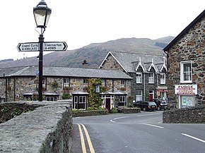
120:
1114:
311:
454:
367:
259:
1209:
374:. At its west end, the route crosses the new A487 Porthmadog Bypass at a roundabout west of Tremadog.
310:
about a mile west of
Porthmadog. At its northern end, the road forms a link via the A4086 with the
959:
558:
348:
481:
543:
476:
263:
1094:
319:
247:
471:
440:
239:
164:
1327:
1219:
1276:
1264:
944:
371:
924:
315:
229:
221:
1214:
1199:
1194:
1189:
1184:
1179:
1174:
1169:
1164:
1159:
1154:
1139:
1134:
1129:
1124:
1119:
1109:
1104:
1089:
1084:
1079:
1074:
1069:
1064:
1059:
1054:
1049:
1044:
1039:
1034:
1029:
1024:
1019:
1014:
1009:
1004:
999:
994:
989:
984:
979:
974:
969:
964:
954:
949:
939:
934:
929:
919:
251:
243:
236:
225:
43:
1301:
1287:
287:
273:
135:
122:
90:
76:
1204:
1144:
906:
896:
891:
886:
881:
876:
871:
866:
861:
856:
851:
846:
841:
836:
831:
826:
821:
816:
811:
806:
801:
796:
791:
786:
781:
776:
771:
766:
761:
756:
751:
746:
741:
736:
731:
726:
721:
716:
711:
706:
701:
696:
691:
686:
681:
676:
671:
666:
661:
656:
651:
646:
641:
636:
631:
621:
616:
611:
392:
325:
26:
593:
588:
583:
578:
573:
568:
563:
553:
548:
466:
255:
533:
420:
370:, now being reconstructed, can be seen on the opposite side of the
324:
174:
495:
258:
and crosses the A487 at a roundabout, before passing under the
441:
https://www.festipedia.org.uk/Bryn_y_Felin_Road_bridge
1248:
343:
miles section with limited width and poor alignment
184:
170:
160:
155:
114:
68:
63:
55:
50:
23:
397:Portmadoc, Beddgelert and South Snowdon Railway
329:The A498 descends the Nant Gwynant Pass via a
507:
8:
42:The A498 at its junction with the A4085 in
514:
500:
492:
1255:
408:
20:
7:
524:Great Britain road numbering scheme
14:
1270:
1258:
532:
391:The road was created from early
254:. The A498 then passes through
59:14.8 mi (23.8 km)
36:
25:
1:
347:There is a steep descent of
482:GPX (secondary coordinates)
194:Roads in the United Kingdom
1350:
220:is a 16-mile road between
1238:List of B roads in Zone 4
1233:List of A roads in Zone 4
1228:
915:
602:
539:
530:
522:A roads in Zone 4 of the
477:GPX (primary coordinates)
452:Map all coordinates using
189:
180:
151:
35:
460:Download coordinates as:
299:A498 road (southern end)
250:, where it overlaps the
102:A498 road (northern end)
368:Welsh Highland Railway
344:
260:Cambrian Coast railway
472:GPX (all coordinates)
328:
417:"Directions to A498"
235:At Pen-y-Gwryd, the
1297: /
378:Recent improvements
283: /
262:and terminating at
171:Constituent country
132: /
86: /
16:A road in Wales, UK
1302:53.0179°N 4.0946°W
345:
288:52.9336°N 4.1543°W
207:A and B road zones
136:52.9336°N 4.1543°W
91:53.0819°N 4.0022°W
1246:
1245:
214:
213:
51:Route information
1341:
1334:Roads in Gwynedd
1321:
1320:
1318:
1317:
1316:
1314:
1309:
1308:
1307:53.0179; -4.0946
1303:
1298:
1295:
1294:
1293:
1290:
1275:
1274:
1273:
1263:
1262:
1261:
1254:
536:
516:
509:
502:
493:
443:
438:
432:
431:
429:
427:
413:
399:but never used.
364:
363:
359:
356:
342:
341:
337:
334:
320:Pont Aberglaslyn
309:
307:
306:
304:
303:
302:
300:
295:
294:
293:52.9336; -4.1543
289:
284:
281:
280:
279:
276:
248:Aberglaslyn Pass
147:
146:
144:
143:
142:
141:52.9336; -4.1543
137:
133:
130:
129:
128:
125:
110:
109:
107:
106:
105:
103:
98:
97:
96:53.0819; -4.0022
92:
87:
84:
83:
82:
79:
40:
29:
21:
1349:
1348:
1344:
1343:
1342:
1340:
1339:
1338:
1324:
1323:
1312:
1310:
1306:
1304:
1300:
1299:
1296:
1291:
1288:
1286:
1284:
1283:
1281:
1271:
1269:
1259:
1257:
1249:
1247:
1242:
1224:
911:
598:
537:
526:
520:
490:
489:
488:
487:
486:
447:
446:
439:
435:
425:
423:
415:
414:
410:
405:
389:
380:
361:
357:
354:
352:
339:
335:
332:
330:
298:
296:
292:
290:
286:
285:
282:
277:
274:
272:
270:
269:
267:
140:
138:
134:
131:
126:
123:
121:
119:
118:
101:
99:
95:
93:
89:
88:
85:
80:
77:
75:
73:
72:
64:Major junctions
46:
30:
17:
12:
11:
5:
1347:
1345:
1337:
1336:
1326:
1325:
1280:
1279:
1267:
1244:
1243:
1241:
1240:
1235:
1229:
1226:
1225:
1223:
1222:
1217:
1212:
1207:
1202:
1197:
1192:
1187:
1182:
1177:
1172:
1167:
1162:
1157:
1152:
1147:
1142:
1137:
1132:
1127:
1122:
1117:
1112:
1107:
1102:
1097:
1092:
1087:
1082:
1077:
1072:
1067:
1062:
1057:
1052:
1047:
1042:
1037:
1032:
1027:
1022:
1017:
1012:
1007:
1002:
997:
992:
987:
982:
977:
972:
967:
962:
957:
952:
947:
942:
937:
932:
927:
922:
916:
913:
912:
910:
909:
904:
899:
894:
889:
884:
879:
874:
869:
864:
859:
854:
849:
844:
839:
834:
829:
824:
819:
814:
809:
804:
799:
794:
789:
784:
779:
774:
769:
764:
759:
754:
749:
744:
739:
734:
729:
724:
719:
714:
709:
704:
699:
694:
689:
684:
679:
674:
669:
664:
659:
654:
649:
644:
639:
634:
629:
624:
619:
614:
609:
603:
600:
599:
597:
596:
591:
586:
581:
576:
571:
566:
561:
556:
551:
546:
540:
538:
531:
528:
527:
521:
519:
518:
511:
504:
496:
485:
484:
479:
474:
469:
463:
457:
450:
449:
448:
445:
444:
433:
407:
406:
404:
401:
388:
385:
379:
376:
240:Llanberis Pass
212:
211:
210:
209:
204:
198:
197:
187:
186:
182:
181:
178:
177:
172:
168:
167:
165:United Kingdom
162:
158:
157:
153:
152:
149:
148:
116:
115:south end
112:
111:
70:
69:north end
66:
65:
61:
60:
57:
53:
52:
48:
47:
41:
33:
32:
24:
15:
13:
10:
9:
6:
4:
3:
2:
1346:
1335:
1332:
1331:
1329:
1322:
1319:
1278:
1268:
1266:
1256:
1252:
1239:
1236:
1234:
1231:
1230:
1227:
1221:
1218:
1216:
1213:
1211:
1208:
1206:
1203:
1201:
1198:
1196:
1193:
1191:
1188:
1186:
1183:
1181:
1178:
1176:
1173:
1171:
1168:
1166:
1163:
1161:
1158:
1156:
1153:
1151:
1148:
1146:
1143:
1141:
1138:
1136:
1133:
1131:
1128:
1126:
1123:
1121:
1118:
1116:
1113:
1111:
1108:
1106:
1103:
1101:
1098:
1096:
1093:
1091:
1088:
1086:
1083:
1081:
1078:
1076:
1073:
1071:
1068:
1066:
1063:
1061:
1058:
1056:
1053:
1051:
1048:
1046:
1043:
1041:
1038:
1036:
1033:
1031:
1028:
1026:
1023:
1021:
1018:
1016:
1013:
1011:
1008:
1006:
1003:
1001:
998:
996:
993:
991:
988:
986:
983:
981:
978:
976:
973:
971:
968:
966:
963:
961:
958:
956:
953:
951:
948:
946:
943:
941:
938:
936:
933:
931:
928:
926:
923:
921:
918:
917:
914:
908:
905:
903:
900:
898:
895:
893:
890:
888:
885:
883:
880:
878:
875:
873:
870:
868:
865:
863:
860:
858:
855:
853:
850:
848:
845:
843:
840:
838:
835:
833:
830:
828:
825:
823:
820:
818:
815:
813:
810:
808:
805:
803:
800:
798:
795:
793:
790:
788:
785:
783:
780:
778:
775:
773:
770:
768:
765:
763:
760:
758:
755:
753:
750:
748:
745:
743:
740:
738:
735:
733:
730:
728:
725:
723:
720:
718:
715:
713:
710:
708:
705:
703:
700:
698:
695:
693:
690:
688:
685:
683:
680:
678:
675:
673:
670:
668:
665:
663:
660:
658:
655:
653:
650:
648:
645:
643:
640:
638:
635:
633:
630:
628:
625:
623:
620:
618:
615:
613:
610:
608:
605:
604:
601:
595:
592:
590:
587:
585:
582:
580:
577:
575:
572:
570:
567:
565:
562:
560:
557:
555:
552:
550:
547:
545:
542:
541:
535:
529:
525:
517:
512:
510:
505:
503:
498:
497:
494:
483:
480:
478:
475:
473:
470:
468:
465:
464:
462:
461:
456:
455:OpenStreetMap
453:
442:
437:
434:
422:
418:
412:
409:
402:
400:
398:
394:
386:
384:
377:
375:
373:
369:
350:
327:
323:
321:
317:
313:
305:
265:
261:
257:
253:
249:
245:
241:
238:
233:
231:
227:
223:
219:
208:
205:
203:
200:
199:
196:
195:
191:
190:
188:
183:
179:
176:
173:
169:
166:
163:
159:
154:
150:
145:
117:
113:
108:
71:
67:
62:
58:
54:
49:
45:
39:
34:
28:
22:
19:
1282:
901:
459:
458:
451:
436:
424:. Retrieved
411:
390:
381:
372:Afon Glaslyn
346:
266:on the A497
234:
217:
215:
192:
185:Road network
18:
1305: /
349:Nantgwynant
316:Capel Curig
291: /
230:North Wales
222:Pen-y-Gwryd
139: /
94: /
1311: (
1289:53°01′04″N
403:References
393:toll roads
297: (
275:52°56′01″N
244:Beddgelert
226:Porthmadog
124:52°56′01″N
100: (
78:53°04′55″N
44:Beddgelert
1313:A498 road
1292:4°05′41″W
351:and some
278:4°09′15″W
202:Motorways
127:4°09′15″W
81:4°00′08″W
1328:Category
426:17 April
264:Penamser
256:Tremadog
246:and the
156:Location
1251:Portals
387:History
360:⁄
338:⁄
161:Country
421:Google
56:Length
1277:Wales
1265:Roads
1220:A4540
1215:A4536
1210:A4400
1205:A4361
1200:A4260
1195:A4241
1190:A4240
1185:A4234
1180:A4232
1175:A4230
1170:A4226
1165:A4221
1160:A4216
1155:A4214
1150:A4204
1145:A4202
1140:A4200
1135:A4174
1130:A4161
1125:A4160
1120:A4155
1115:A4150
1110:A4148
1105:A4146
1100:A4144
1095:A4142
1090:A4138
1085:A4136
1080:A4135
1075:A4133
1070:A4130
1065:A4123
1060:A4119
1055:A4118
1050:A4117
1045:A4113
1040:A4110
1035:A4109
1030:A4107
1025:A4103
1020:A4086
1015:A4085
1010:A4080
1005:A4076
1000:A4074
995:A4069
990:A4063
985:A4061
980:A4060
975:A4059
970:A4055
965:A4054
960:A4053
955:A4050
950:A4042
945:A4032
940:A4018
935:A4010
930:A4008
925:A4006
920:A4005
252:A4085
237:A4086
175:Wales
907:A499
902:A498
897:A496
892:A494
887:A493
882:A491
877:A490
872:A489
867:A487
862:A486
857:A485
852:A483
847:A482
842:A479
837:A478
832:A477
827:A476
822:A475
817:A474
812:A473
807:A470
802:A469
797:A468
792:A466
787:A465
782:A461
777:A458
772:A456
767:A454
762:A453
757:A452
752:A449
747:A448
742:A446
737:A445
732:A444
727:A442
722:A441
717:A433
712:A432
707:A431
702:A429
697:A428
692:A427
687:A426
682:A423
677:A422
672:A421
667:A420
662:A419
657:A418
652:A417
647:A415
642:A414
637:A413
632:A412
627:A406
622:A405
617:A404
612:A403
607:A400
428:2013
224:and
218:A498
216:The
31:A498
594:A49
589:A48
584:A47
579:A46
574:A45
569:A44
564:A43
559:A42
554:A41
549:A40
467:KML
314:at
228:in
1330::
544:A4
419:.
312:A5
308:),
232:.
1315:)
1253::
515:e
508:t
501:v
430:.
362:4
358:3
355:+
353:1
340:4
336:3
333:+
331:1
301:)
268:(
104:)
Text is available under the Creative Commons Attribution-ShareAlike License. Additional terms may apply.