38:
101:
92:
219:
204:
291:
83:
50:
636:
512:
In June 2008, the Road Safety
Foundation announced that the most dangerous road in Scotland was the 27 km stretch of the A99 between the A9 at Latheron and Wick. With twelve fatal and serious casualty accidents in three years between 2004 and 2006, the road was one of only four roads in Great
821:
816:
533:
879:
615:
565:
182:
835:
320:
187:
625:
305:
469:
442:
406:
385:
367:
338:
541:
608:
274:. It was part of the A9 until the A9 classification was transferred to what had been the A895-A882 link between Latheron and
174:
874:
588:
601:
222:
104:
95:
889:
593:
207:
494:
423:
411:
390:
332:
255:
247:
86:
583:
562:
474:
451:
884:
645:
459:
304:
The A99 runs through or near towns and villages listed below. Junctions listed are with other
271:
155:
114:
482:
569:
435:
375:
347:
317:
263:
17:
294:
279:
151:
140:
133:
868:
490:
708:
298:
850:
837:
803:
798:
793:
788:
783:
778:
773:
768:
763:
758:
753:
748:
743:
738:
733:
728:
723:
718:
713:
463:
447:
415:
394:
379:
343:
267:
243:
147:
290:
563:
Highest risk road sections in each UK Government Office Region (2004–2006)
49:
690:
685:
680:
675:
670:
665:
660:
655:
650:
328:
259:
251:
69:
37:
635:
514:
419:
351:
478:
427:
355:
275:
278:. Between Latheron and Wick it follows, mostly, the route of one of
486:
289:
498:
239:
597:
410:. From Lochshell the B874 runs west to a crossroads with the
534:"Scothighlands – Drive from Inverness to John O'Groats"
473:. From John o' Groats the A836 runs generally west to
513:
Britain rated as Black—the highest risk band—in the
342:. From Latheron the A9 runs generally (1) south to
165:
139:
129:
124:
110:
75:
65:
60:
34:
389:. From Wick the A882 runs west/northwest to the
609:
254:. It runs generally north/northeast from the
8:
446:. From Reiss the B876 runs northwest to the
616:
602:
594:
196:
310:
242:is entirely within the former county of
584:EuroRAP GB Tracking Survey Results 2008
525:
31:
7:
880:Transport in Highland (council area)
27:Major road in Highland, Scotland, UK
626:Great Britain road numbering scheme
25:
634:
217:
202:
99:
90:
81:
48:
36:
1:
286:Towns, villages and junctions
175:Roads in the United Kingdom
906:
822:List of B roads in Zone 9
817:List of A roads in Zone 9
812:
704:
641:
632:
624:A roads in Zone 9 of the
195:
170:
161:
120:
46:
568:10 February 2012 at the
422:, and then north to the
18:A99 road (Great Britain)
589:Road Safety Foundation
301:
297:carrying the A99 over
293:
851:58.42218°N 3.10083°W
314:Places and junctions
55:Click map to enlarge
847: /
354:, and (2) north to
77:Major intersections
856:58.42218; -3.10083
485:and then south to
302:
188:A and B road zones
875:Roads in Scotland
830:
829:
538:scothighlands.com
505:
504:
233:
232:
229:
228:
16:(Redirected from
897:
862:
861:
859:
858:
857:
852:
848:
845:
844:
843:
840:
638:
618:
611:
604:
595:
572:
560:
554:
553:
551:
549:
540:. Archived from
530:
472:
445:
409:
388:
370:
341:
311:
306:classified roads
225:
221:
220:
210:
206:
205:
197:
103:
102:
94:
93:
85:
84:
78:
52:
40:
32:
21:
905:
904:
900:
899:
898:
896:
895:
894:
890:Wick, Caithness
865:
864:
855:
853:
849:
846:
841:
838:
836:
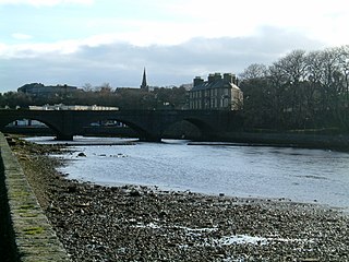
834:
833:
831:
826:
808:
700:
639:
628:
622:
580:
575:
570:Wayback Machine
561:
557:
547:
545:
544:on 25 June 2022
532:
531:
527:
523:
510:
468:
441:
405:
402:Lochshell, B874
384:
366:
337:
321:grid references
318:Ordnance Survey
288:
218:
216:
203:
201:
142:
100:
98:
91:
89:
82:
76:
61:Major junctions
56:
53:
41:
28:
23:
22:
15:
12:
11:
5:
903:
901:
893:
892:
887:
882:
877:
867:
866:
828:
827:
825:
824:
819:
813:
810:
809:
807:
806:
801:
796:
791:
786:
781:
776:
771:
766:
761:
756:
751:
746:
741:
736:
731:
726:
721:
716:
711:
705:
702:
701:
699:
698:
693:
688:
683:
678:
673:
668:
663:
658:
653:
648:
642:
640:
633:
630:
629:
623:
621:
620:
613:
606:
598:
592:
591:
586:
579:
578:External links
576:
574:
573:
555:
524:
522:
519:
509:
506:
503:
502:
466:
460:John o' Groats
456:
455:
439:
432:
431:
418:area, then to
403:
399:
398:
382:
372:
371:
364:
360:
359:
335:
325:
324:
315:
295:Bridge of Wick
287:
284:
272:John o' Groats
231:
230:
227:
226:
213:
211:
193:
192:
191:
190:
185:
179:
178:
168:
167:
163:
162:
159:
158:
156:John o' Groats
145:
137:
136:
134:United Kingdom
131:
127:
126:
122:
121:
118:
117:
115:John o' Groats
112:
111:North end
108:
107:
79:
73:
72:
67:
66:South end
63:
62:
58:
57:
54:
47:
44:
43:
35:
26:
24:
14:
13:
10:
9:
6:
4:
3:
2:
902:
891:
888:
886:
883:
881:
878:
876:
873:
872:
870:
863:
860:
823:
820:
818:
815:
814:
811:
805:
802:
800:
797:
795:
792:
790:
787:
785:
782:
780:
777:
775:
772:
770:
767:
765:
762:
760:
757:
755:
752:
750:
747:
745:
742:
740:
737:
735:
732:
730:
727:
725:
722:
720:
717:
715:
712:
710:
707:
706:
703:
697:
694:
692:
689:
687:
684:
682:
679:
677:
674:
672:
669:
667:
664:
662:
659:
657:
654:
652:
649:
647:
644:
643:
637:
631:
627:
619:
614:
612:
607:
605:
600:
599:
596:
590:
587:
585:
582:
581:
577:
571:
567:
564:
559:
556:
543:
539:
535:
529:
526:
520:
518:
516:
507:
500:
496:
492:
488:
484:
480:
476:
471:
467:
465:
461:
458:
457:
453:
449:
444:
440:
437:
434:
433:
429:
425:
421:
417:
413:
408:
404:
401:
400:
396:
392:
387:
383:
381:
377:
374:
373:
369:
365:
362:
361:
357:
353:
349:
345:
340:
336:
334:
330:
327:
326:
322:
319:
316:
313:
312:
309:
307:
300:
296:
292:
285:
283:
281:
277:
273:
269:
265:
261:
257:
253:
249:
245:
241:
238:
224:
214:
212:
209:
199:
198:
194:
189:
186:
184:
181:
180:
177:
176:
172:
171:
169:
164:
160:
157:
153:
149:
146:
144:
138:
135:
132:
128:
123:
119:
116:
113:
109:
106:
97:
88:
80:
74:
71:
68:
64:
59:
51:
45:
39:
33:
30:
19:
832:
695:
558:
546:. Retrieved
542:the original
537:
528:
511:
491:Bonar Bridge
323:& notes
303:
236:
234:
173:
166:Road network
143:destinations
29:
854: /
548:25 November
508:Road safety
266:and to the
869:Categories
839:58°25′20″N
521:References
475:Castletown
452:Castletown
299:Wick River
282:'s roads.
885:Caithness
842:3°06′03″W
493:then the
416:Georgemas
395:Georgemas
363:Thrumster
344:Inverness
244:Caithness
183:Motorways
148:Inverness
566:Archived
517:report.
470:ND380727
443:ND333547
407:ND353526
386:ND362506
368:ND336452
339:ND199335
329:Latheron
260:Latheron
252:Scotland
248:Highland
125:Location
70:Latheron
515:EuroRAP
420:Halkirk
414:in the
393:in the
352:Falkirk
280:Telford
246:in the
141:Primary
130:Country
483:Tongue
479:Thurso
438:, B876
428:Thurso
397:area.
356:Thurso
276:Thurso
497:near
487:Lairg
436:Reiss
348:Perth
804:A991
799:A989
794:A980
789:A972
784:A970
779:A968
774:A961
769:A957
764:A956
759:A952
754:A950
749:A949
744:A947
739:A944
734:A939
729:A930
724:A923
719:A921
714:A912
709:A900
550:2019
499:Tain
489:and
481:and
464:A836
448:A836
380:A882
376:Wick
350:and
268:A836
264:Wick
240:road
235:The
223:A100
152:Wick
105:A882
96:A836
696:A99
691:A98
686:A97
681:A96
676:A95
671:A94
666:A93
661:A92
656:A91
651:A90
450:at
426:in
270:at
262:to
258:at
250:of
237:A99
208:A98
42:A99
871::
646:A9
536:.
501:.
495:A9
477:,
462:,
454:.
430:.
424:A9
412:A9
391:A9
378:,
358:.
346:,
333:A9
331:,
308:.
256:A9
215:→
200:←
154:,
150:,
87:A9
617:e
610:t
603:v
552:.
20:)
Text is available under the Creative Commons Attribution-ShareAlike License. Additional terms may apply.