229:, Germany, when the aircraft was attacked by a German nightfighter. With one engine on fire and the flames having spread along the fuselage, the crew attempted to land at Boxted airfield, where the Americans switched on the runway landing lights. The Lancaster just failed to reach Boxted and crashed near to what is now Safestore on Ipswich Road, killing all seven crew, four British and three Canadian. In 2013 a group of Colcestrians interested in the Second World War, inspired by one of their number who, as a boy, had actually seen the Lancaster just before it crashed, erected a memorial near the site, with the kind permission of Safestore. A memorial service was held in 2013, on the anniversary of the crash, and has been held every year since. The Colchester Gazette has recorded these services every year, the 2015 article including a picture of the service :
33:
241:
200:
313:
270:
144:
253:, saying a more appropriate name would be after the 1944 Lancaster Bomber crash. The group of friends who established the memorial to the Lancaster crew approached Colchester Borough Council who kindly agreed to name the seven roads in the estate after the seven members of the Lancaster crew, and the entry road to the estate is named Lancaster Approach, with a metal silhouette of a Lancaster as part of the road sign.
1347:
191:, but it only held about 25 or 30 prisoners, both male and female, at any one time. When the War Office re-authorized the militia in 1845 the 14th East Essex Regiment of Militia, which later became the Essex Rifles Militia, was given the old County Gaol as its headquarters. In 1875, the County Police Station was located on the Ipswich Road.
320:
The northern part of the road is characterised by industrial estates. There is retail centre selling cars, including
Porsche Centre Colchester and Underwoods Mazda and Autoway Colchester. Colchester Business Park is at the northern end of the road, next to the A12 and A120. It contains 250,000 square
248:
The toothpaste tube manufacturer Betts opened a factory at No. 505 Ipswich road in 1953. In 2008, the firm decided to close the factory and moved to smaller premises elsewhere in town. In 2014, Bellway Homes announced they would convert the former
Ipswich Road factory into a housing estate named
304:
is set in a Grade II listed farmhouse dated to the 17th century, with additional extensions in the mid-18th, although an earlier building dated to 1353. In 1983, the building became a pub. Timber framed, it is a two-storey building with five windows and a panelled door. Just to the north is St.
186:
At the edge of the
Greenstead Parish boundary is Rovers Tye Farm, which has been documented as being established by 1353. A new causeway at this location had been built by 1429, by which point Ipswich Road ran on its current route. This road was turnpiked in 1725, when the road was predominantly
74:
Rovers Tye Farm, a pub since 1983, was established by 1353, and a causeway at this location had been built by 1429, by which point
Ipswich Road ran on its current route. The road once contained the County Gaol and County Police Station. The Grade II listed St. John's Church was built in 1864 by
232:
In
December 2014, 24 World War II bombs weighing approximately 600 lbs in total were discovered at a recycling centre on the road. After the war, there were small private developments off Mersea Road, "west of Lexden Park, north of Colchester North railway station, between Ipswich Road and the
79:. The toothpaste tube manufacturer Betts opened a factory at No. 505 Ipswich Road in 1953. More recently there have been the development of housing and industrial estates along the road, particularly automobile dealers, at the northern end where it meets the A12.
699:
288:
in the 14th century and used as a stopping point for prisoners being transported from Europe and
Suffolk to London. The building still contains two cells, retaining their original doors. The venue's fireplace dates from the Tudor period.
256:
The road was part of the A12 when road numbers were first classified in 1922, and remained the main route to
Ipswich for motor traffic until the Northern Colchester Bypass opened in 1974, which was extended towards
709:
309:. It is built from "red and gault brick with stone dressings and peg tile gabled roofs" and features a "circular bell turret with conical roof". It became a Grade II listed building in 1986.
908:
1890:
1885:
292:
Beyond the railway bridge is the St Johns Post Office and Milton Lodge at No. 290 Ipswich Road, almost opposite it. Milton Lodge is a residential care home for elderly
1006:
215:
to form the embankment for the railway bridge. The sand was topped with clay. The bridge crossing the Great
Eastern Main Line underwent major reconstruction in 1957.
388:
1326:
237:
began developing the 730 acre High Woods site to the west of the road. Around 4000 houses and a shopping centre were subsequently built in the vicinity.
420:
915:
175:. The London–Ipswich road passing through Colchester provided a vital economic connection to the capital, 51 miles (82 km) away, during the
130:. The main bus routes from Colchester to Ipswich, 93 and 94, run along the road. It also serves a portion of the Colchester half marathon route.
1246:
1225:
1182:
1156:
1100:
1079:
1053:
1275:
834:
1336:
240:
207:
The road was bisected by the first
Colchester Bypass in 1933, an unemployment relief project. The railway bridge was also built in the
808:
296:
sufferers and was converted into a care home in 2001. Further north, at the roundabout with
Highwoods Approach and St. John's Road, is
199:
321:
feet (23,000 m) of office space. It contains the Premier Inn and further car retailers such as Cooper BMW and Glyn Hopkin Honda.
159:, thereby heading northeast to meet the current road. An excavation in 1930 found evidence of road ditches on this alignment. In 991
155:, but the ancient route to Ipswich followed a different path, leaving Duncan's Gate and heading east of Castle Park and crossing the
1128:
187:
rural in nature. In 1841, a prison, known as the House of Correction or County Gaol, was built on the road to alleviate pressure on
32:
349:
1013:
782:
1319:
984:
962:
395:
700:"Inquiry begins to find who dumped 24 World War Two bombs weighing around 600lbs in total at recycling plant near Ipswich"
673:
614:
211:
of the 1930s, using government funding. 7-ton locomotives were used to bring sand via a light railway from a pit on the
312:
1916:
183:(1642–51) built Fort Suffolk to the north of Ipswich Road, one of eleven earthen fieldworks with timber palisades.
305:
John's Primary School, and St. John's Church beyond this. The church was built in 1864 by Arthur Blomfield in the
171:. Brihtnoth entered the well-defended town of Colchester by the Ipswich road on his way south, later dying at the
1312:
269:
218:
On 12 November 1940 Colchester was bombed by German air raids, causing damage in the vicinity of Ipswich Road.
1304:
858:
147:
Colchester around 1500. The Ipswich road branches north off the Harwich Road, which runs towards the northeast.
212:
1911:
1419:
1356:
88:
37:
1832:
634:
306:
123:
76:
233:
railway, and north of East Hill". St. John's housing estate was built in the 1960s, and in 1979, the
1669:
1659:
1654:
1649:
1624:
1504:
1479:
1469:
1459:
1454:
1439:
940:
108:
1737:
1424:
1401:
1396:
1391:
1386:
1381:
1376:
1371:
1366:
1361:
1199:
156:
104:
92:
64:
1242:
1236:
1221:
1178:
1152:
1124:
1096:
1075:
1049:
764:
276:
on Ipswich Road has previously been a farmhouse, with records dating back to the 14th century.
188:
180:
127:
1215:
1146:
1090:
1043:
758:
1118:
732:
528:
498:
208:
172:
164:
167:, decided to check the Danes. They had plundered Ipswich and were sailing south to plunder
886:
647:
116:
1193:
222:
1263:
143:
1905:
168:
152:
704:
285:
176:
221:
In the early hours of 25th April 1944, a crew of seven on board a Royal Air Force
353:
68:
60:
1872:
1867:
1862:
1857:
1852:
1842:
1837:
1827:
1822:
1817:
1812:
1807:
1802:
1797:
1792:
1787:
1782:
1777:
1772:
1767:
1762:
1757:
1752:
1747:
1742:
1732:
1727:
1722:
1717:
1712:
1707:
1702:
1697:
1692:
1687:
1682:
234:
52:
1290:
1277:
768:
1664:
1644:
1639:
1634:
1629:
1619:
1614:
1609:
1604:
1599:
1594:
1589:
1584:
1579:
1574:
1569:
1564:
1559:
1554:
1549:
1544:
1539:
1534:
1529:
1524:
1519:
1514:
1509:
1499:
1494:
1489:
1484:
1474:
1464:
1449:
1444:
1434:
1429:
226:
160:
17:
1406:
1267:
293:
250:
249:
Avellana Place. Locals protested against the name, which is Spanish for
1346:
863:
258:
112:
100:
56:
1148:
Defending Essex: The Military Landscape from Prehistory to the Present
55:, Essex, England. It was the historic coaching route and main road to
421:"Thousands of runners to take part in Colchester Half Marathon today"
96:
311:
268:
244:
A plaque commemorating the widening of Ipswich Road Bridge in 1931
239:
198:
142:
1175:
Colchester, Fortress of the War God: an Archaeological Assessment
284:
is at the southern end of Ipswich Road. It was established as a
126:
aside from a small portion at the northern end, which is in the
1308:
225:(UM-K2 serial DV 177) were returning from a bombing raid on
203:
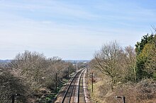
Looking west down the mainline from the Ipswich Road Bridge
1045:
Foul Deeds and Suspicious Deaths in and Around Colchester
763:. Reed Business Information. 11 March 1989. p. 14.
87:
The road runs northeast from East Street, crossing the
985:"Church of St Johns (Church of England), Colchester"
836:
Ministry of Transport Road Map Sheet 30 (Colchester)
179:. The royalist defenders of Colchester during the
783:"Buyout secures 180 jobs at toothpaste tube firm"
1195:The History and Antiquities of Colchester Castle
739:. 9, the Borough of Colchester. London: 199–208
535:. 9, the Borough of Colchester. London: 382–390
505:. 9, the Borough of Colchester. London: 233–237
445:
809:"Confusion as new estate is called 'hazelnut'"
1320:
1217:E J Rudsdale's Journals of Wartime Colchester
674:"Ceremony marks Colchester crash anniversary"
522:
520:
377:(Map). Ordnance Survey Landranger. 2015. 168.
8:
1120:Godliness and Governance in Tudor Colchester
1012:. Colchesterbusinesspark.com. Archived from
887:"Rose & Crown Hotel, Colchester (Essex)"
731:Cooper, Janet; Elrington, C R, eds. (1994).
527:Cooper, Janet; Elrington, C R, eds. (1994).
497:Cooper, Janet; Elrington, C R, eds. (1994).
529:"Outlying parts of the Liberty: Greenstead"
1327:
1313:
1305:
1173:Radford, David; Gascoyne, Adrian (2013).
660:
151:Colchester has been inhabited since pre-
31:
565:
492:
490:
481:
334:
122:The majority of the road is within the
36:Looking south on Ipswich Road from the
643:
632:
601:
589:
577:
91:, to Ardleigh Wick where it meets the
71:, until the A12 was rerouted in 1974.
733:"Modern Colchester: Town development"
469:
457:
7:
553:
344:
342:
340:
338:
1337:Great Britain road numbering scheme
1145:Osborne, Mike (28 February 2013).
963:"Rovers Tye Farmhouse, Colchester"
708:. 19 December 2014. Archived from
25:
1089:Denney, Patrick (14 March 2014).
914:. Housingcare.org. Archived from
394:. Suffolk Onboard. Archived from
307:High Victorian Early Gothic style
77:High Victorian Early Gothic style
1345:
1198:. Benham & Company. p.
1123:. University of Michigan Press.
737:A History of the County of Essex
533:A History of the County of Essex
503:A History of the County of Essex
1235:Webb, Simon (31 January 2013).
1095:. Amberley Publishing Limited.
1074:. Amberley Publishing Limited.
864:Parliamentary Debates (Hansard)
375:Colchester, Halstead and Maldon
298:The Rovers Tye – Flaming Grill
40:towards Colchester town centre
1:
1214:Rudsdale, E J (1 June 2013).
63:onwards, and was part of the
1238:The Colchester Book of Days
1192:Round, John Horace (1882).
446:Radford & Gascoyne 2013
27:Road in Colchester, England
1933:
1117:Higgs, Laquita M. (1998).
1007:"Colchester Business Park"
987:. British Listed Buildings
965:. British Listed Buildings
1891:List of B roads in Zone 1
1886:List of A roads in Zone 1
1881:
1678:
1415:
1352:
1343:
1335:A roads in Zone 1 of the
1070:Denney, Patrick (2013).
1042:Denney, Patrick (2005).
75:Arthur Blomfield in the
1241:. Perseus Books Group.
1072:Colchester Through Time
1048:. Casemate Publishers.
389:"93/93C/X93/94/94A/94C"
115:(and hence by ferry to
89:Great Eastern Main Line
38:Great Eastern Main Line
943:. flaminggrillpubs.com
642:Cite journal requires
317:
277:
245:
204:
148:
41:
315:
272:
243:
202:
146:
124:Borough of Colchester
35:
1291:51.89320°N 0.91773°E
921:on 24 September 2015
401:on 24 September 2015
95:, a major road from
1287: /
1092:Colchester Memories
1019:on 5 September 2015
712:on 5 September 2015
195:20th – 21st century
163:, Ealdorman of the
889:. Historic Britain
867:. 25 November 1982
813:Colchester Gazette
787:Colchester Gazette
678:Colchester Gazette
425:Colchester Gazette
318:
278:
246:
205:
149:
105:Port of Felixstowe
42:
1917:Colchester (town)
1899:
1898:
1296:51.89320; 0.91773
1248:978-0-7524-8908-7
1227:978-0-7509-5280-4
1220:. History Press.
1184:978-1-782-97075-0
1158:978-0-7524-9237-7
1151:. History Press.
1102:978-1-4456-1873-9
1081:978-1-445-62753-3
1055:978-1-903425-80-0
815:. 31 October 2014
789:. 30 January 2011
460:, pp. 14–15.
189:Colchester Castle
181:English Civil War
128:Tendring District
67:, a main road in
16:(Redirected from
1924:
1349:
1329:
1322:
1315:
1306:
1302:
1301:
1299:
1298:
1297:
1292:
1288:
1285:
1284:
1283:
1280:
1252:
1231:
1210:
1208:
1206:
1188:
1169:
1167:
1165:
1141:
1139:
1137:
1113:
1111:
1109:
1085:
1066:
1064:
1062:
1029:
1028:
1026:
1024:
1018:
1011:
1003:
997:
996:
994:
992:
981:
975:
974:
972:
970:
959:
953:
952:
950:
948:
937:
931:
930:
928:
926:
920:
913:
905:
899:
898:
896:
894:
883:
877:
876:
874:
872:
855:
849:
848:
846:
844:
831:
825:
824:
822:
820:
805:
799:
798:
796:
794:
779:
773:
772:
755:
749:
748:
746:
744:
728:
722:
721:
719:
717:
696:
690:
689:
687:
685:
670:
664:
658:
652:
651:
645:
640:
638:
630:
628:
626:
611:
605:
599:
593:
587:
581:
575:
569:
568:, p. 37–38.
563:
557:
551:
545:
544:
542:
540:
524:
515:
514:
512:
510:
499:"Communications"
494:
485:
479:
473:
467:
461:
455:
449:
443:
437:
436:
434:
432:
417:
411:
410:
408:
406:
400:
393:
385:
379:
378:
371:
365:
364:
362:
360:
346:
316:St John's Church
209:Great Depression
173:Battle of Maldon
139:Pre 20th century
47:, formally the
21:
1932:
1931:
1927:
1926:
1925:
1923:
1922:
1921:
1902:
1901:
1900:
1895:
1877:
1674:
1411:
1350:
1339:
1333:
1295:
1293:
1289:
1286:
1281:
1278:
1276:
1274:
1273:
1260:
1255:
1249:
1234:
1228:
1213:
1204:
1202:
1191:
1185:
1177:. Oxbow Books.
1172:
1163:
1161:
1159:
1144:
1135:
1133:
1131:
1116:
1107:
1105:
1103:
1088:
1082:
1069:
1060:
1058:
1056:
1041:
1032:
1022:
1020:
1016:
1009:
1005:
1004:
1000:
990:
988:
983:
982:
978:
968:
966:
961:
960:
956:
946:
944:
939:
938:
934:
924:
922:
918:
911:
907:
906:
902:
892:
890:
885:
884:
880:
870:
868:
859:"Heavy Lorries"
857:
856:
852:
842:
840:
833:
832:
828:
818:
816:
807:
806:
802:
792:
790:
781:
780:
776:
757:
756:
752:
742:
740:
730:
729:
725:
715:
713:
698:
697:
693:
683:
681:
680:. 30 April 2015
672:
671:
667:
659:
655:
641:
631:
624:
622:
613:
612:
608:
600:
596:
588:
584:
576:
572:
564:
560:
552:
548:
538:
536:
526:
525:
518:
508:
506:
496:
495:
488:
480:
476:
468:
464:
456:
452:
444:
440:
430:
428:
427:. 29 March 2015
419:
418:
414:
404:
402:
398:
391:
387:
386:
382:
373:
372:
368:
358:
356:
348:
347:
336:
327:
267:
197:
141:
136:
117:Hook of Holland
85:
51:, is a road in
28:
23:
22:
15:
12:
11:
5:
1930:
1928:
1920:
1919:
1914:
1912:Roads in Essex
1904:
1903:
1897:
1896:
1894:
1893:
1888:
1882:
1879:
1878:
1876:
1875:
1870:
1865:
1860:
1855:
1850:
1845:
1840:
1835:
1830:
1825:
1820:
1815:
1810:
1805:
1800:
1795:
1790:
1785:
1780:
1775:
1770:
1765:
1760:
1755:
1750:
1745:
1740:
1735:
1730:
1725:
1720:
1715:
1710:
1705:
1700:
1695:
1690:
1685:
1679:
1676:
1675:
1673:
1672:
1667:
1662:
1657:
1652:
1647:
1642:
1637:
1632:
1627:
1622:
1617:
1612:
1607:
1602:
1597:
1592:
1587:
1582:
1577:
1572:
1567:
1562:
1557:
1552:
1547:
1542:
1537:
1532:
1527:
1522:
1517:
1512:
1507:
1502:
1497:
1492:
1487:
1482:
1477:
1472:
1467:
1462:
1457:
1452:
1447:
1442:
1437:
1432:
1427:
1422:
1416:
1413:
1412:
1410:
1409:
1404:
1399:
1394:
1389:
1384:
1379:
1374:
1369:
1364:
1359:
1353:
1351:
1344:
1341:
1340:
1334:
1332:
1331:
1324:
1317:
1309:
1271:
1270:
1259:
1258:External links
1256:
1254:
1253:
1247:
1232:
1226:
1211:
1189:
1183:
1170:
1157:
1142:
1129:
1114:
1101:
1086:
1080:
1067:
1054:
1038:
1031:
1030:
998:
976:
954:
932:
909:"Milton Lodge"
900:
878:
850:
826:
800:
774:
750:
723:
691:
665:
653:
644:|journal=
615:"The Engineer"
606:
594:
582:
570:
558:
556:, p. 295.
546:
516:
486:
484:, p. 3–4.
474:
462:
450:
448:, p. 207.
438:
412:
380:
366:
333:
326:
323:
302:The Rovers Tye
282:Rose And Crown
274:The Rovers Tye
266:
263:
196:
193:
140:
137:
135:
132:
84:
81:
26:
24:
14:
13:
10:
9:
6:
4:
3:
2:
1929:
1918:
1915:
1913:
1910:
1909:
1907:
1892:
1889:
1887:
1884:
1883:
1880:
1874:
1871:
1869:
1866:
1864:
1861:
1859:
1856:
1854:
1851:
1849:
1846:
1844:
1841:
1839:
1836:
1834:
1831:
1829:
1826:
1824:
1821:
1819:
1816:
1814:
1811:
1809:
1806:
1804:
1801:
1799:
1796:
1794:
1791:
1789:
1786:
1784:
1781:
1779:
1776:
1774:
1771:
1769:
1766:
1764:
1761:
1759:
1756:
1754:
1751:
1749:
1746:
1744:
1741:
1739:
1736:
1734:
1731:
1729:
1726:
1724:
1721:
1719:
1716:
1714:
1711:
1709:
1706:
1704:
1701:
1699:
1696:
1694:
1691:
1689:
1686:
1684:
1681:
1680:
1677:
1671:
1668:
1666:
1663:
1661:
1658:
1656:
1653:
1651:
1648:
1646:
1643:
1641:
1638:
1636:
1633:
1631:
1628:
1626:
1623:
1621:
1618:
1616:
1613:
1611:
1608:
1606:
1603:
1601:
1598:
1596:
1593:
1591:
1588:
1586:
1583:
1581:
1578:
1576:
1573:
1571:
1568:
1566:
1563:
1561:
1558:
1556:
1553:
1551:
1548:
1546:
1543:
1541:
1538:
1536:
1533:
1531:
1528:
1526:
1523:
1521:
1518:
1516:
1513:
1511:
1508:
1506:
1503:
1501:
1498:
1496:
1493:
1491:
1488:
1486:
1483:
1481:
1478:
1476:
1473:
1471:
1468:
1466:
1463:
1461:
1458:
1456:
1453:
1451:
1448:
1446:
1443:
1441:
1438:
1436:
1433:
1431:
1428:
1426:
1423:
1421:
1418:
1417:
1414:
1408:
1405:
1403:
1400:
1398:
1395:
1393:
1390:
1388:
1385:
1383:
1380:
1378:
1375:
1373:
1370:
1368:
1365:
1363:
1360:
1358:
1355:
1354:
1348:
1342:
1338:
1330:
1325:
1323:
1318:
1316:
1311:
1310:
1307:
1303:
1300:
1269:
1265:
1262:
1261:
1257:
1250:
1244:
1240:
1239:
1233:
1229:
1223:
1219:
1218:
1212:
1201:
1197:
1196:
1190:
1186:
1180:
1176:
1171:
1160:
1154:
1150:
1149:
1143:
1132:
1130:0-472-10890-5
1126:
1122:
1121:
1115:
1104:
1098:
1094:
1093:
1087:
1083:
1077:
1073:
1068:
1057:
1051:
1047:
1046:
1040:
1039:
1037:
1036:
1015:
1008:
1002:
999:
986:
980:
977:
964:
958:
955:
942:
936:
933:
917:
910:
904:
901:
888:
882:
879:
866:
865:
860:
854:
851:
838:
837:
830:
827:
814:
810:
804:
801:
788:
784:
778:
775:
770:
766:
762:
761:
760:New Scientist
754:
751:
738:
734:
727:
724:
711:
707:
706:
701:
695:
692:
679:
675:
669:
666:
663:, p. 58.
662:
661:Rudsdale 2013
657:
654:
649:
636:
620:
616:
610:
607:
603:
598:
595:
592:, p. 49.
591:
586:
583:
580:, p. 73.
579:
574:
571:
567:
562:
559:
555:
550:
547:
534:
530:
523:
521:
517:
504:
500:
493:
491:
487:
483:
478:
475:
471:
466:
463:
459:
454:
451:
447:
442:
439:
426:
422:
416:
413:
397:
390:
384:
381:
376:
370:
367:
355:
351:
345:
343:
341:
339:
335:
332:
331:
324:
322:
314:
310:
308:
303:
299:
295:
290:
287:
283:
275:
271:
264:
262:
260:
254:
252:
242:
238:
236:
230:
228:
224:
219:
216:
214:
210:
201:
194:
192:
190:
184:
182:
178:
174:
170:
166:
162:
158:
154:
153:Roman Britain
145:
138:
133:
131:
129:
125:
120:
118:
114:
110:
106:
102:
98:
94:
90:
82:
80:
78:
72:
70:
66:
62:
58:
54:
50:
46:
39:
34:
30:
19:
1847:
1272:
1237:
1216:
1203:. Retrieved
1194:
1174:
1162:. Retrieved
1147:
1134:. Retrieved
1119:
1106:. Retrieved
1091:
1071:
1059:. Retrieved
1044:
1034:
1033:
1021:. Retrieved
1014:the original
1001:
989:. Retrieved
979:
967:. Retrieved
957:
945:. Retrieved
941:"Rovers Tye"
935:
923:. Retrieved
916:the original
903:
891:. Retrieved
881:
869:. Retrieved
862:
853:
841:. Retrieved
835:
829:
817:. Retrieved
812:
803:
791:. Retrieved
786:
777:
759:
753:
741:. Retrieved
736:
726:
714:. Retrieved
710:the original
705:Ipswich Star
703:
694:
682:. Retrieved
677:
668:
656:
635:cite journal
623:. Retrieved
618:
609:
597:
585:
573:
566:Osborne 2013
561:
549:
537:. Retrieved
532:
507:. Retrieved
502:
482:Osborne 2013
477:
472:, p. 3.
465:
453:
441:
429:. Retrieved
424:
415:
403:. Retrieved
396:the original
383:
374:
369:
357:. Retrieved
329:
328:
319:
301:
300:restaurant.
297:
291:
286:coaching inn
281:
279:
273:
255:
247:
231:
220:
217:
213:Harwich Road
206:
185:
177:Tudor period
150:
121:
86:
73:
48:
45:Ipswich Road
44:
43:
29:
1294: /
839:(Map). 1923
621:. 1957: 458
602:Denney 2014
590:Denney 2013
578:Denney 2005
354:Google Maps
165:East-Saxons
157:River Colne
69:East Anglia
61:Middle Ages
1906:Categories
1279:51°53′36″N
470:Higgs 1998
458:Round 1882
325:References
235:Kier Group
53:Colchester
18:A1232 road
1282:0°55′04″E
769:0262-4079
554:Webb 2013
431:12 August
330:Citations
265:Landmarks
261:in 1982.
227:Karlsruhe
223:Lancaster
161:Byrhtnoth
59:from the
1205:3 August
1164:4 August
1136:3 August
1108:3 August
1061:4 August
1023:4 August
991:4 August
969:4 August
947:4 August
925:4 August
893:4 August
871:4 August
843:4 August
819:4 August
793:4 August
743:3 August
716:4 August
684:4 August
625:3 August
539:4 August
405:4 August
359:4 August
294:dementia
251:hazelnut
107:and the
103:and the
1035:Sources
604:, PT65.
509:29 July
350:"A1232"
259:Harwich
134:History
113:Harwich
101:Ipswich
57:Ipswich
1245:
1224:
1181:
1155:
1127:
1099:
1078:
1052:
767:
169:Maldon
97:London
1873:A1500
1868:A1309
1863:A1307
1858:A1300
1853:A1237
1848:A1232
1843:A1231
1838:A1205
1833:A1202
1828:A1198
1823:A1175
1818:A1159
1813:A1156
1808:A1144
1803:A1136
1798:A1120
1793:A1107
1788:A1101
1783:A1098
1778:A1095
1773:A1094
1768:A1086
1763:A1085
1758:A1082
1753:A1081
1748:A1079
1743:A1078
1738:A1073
1733:A1071
1728:A1068
1723:A1067
1718:A1065
1713:A1058
1708:A1033
1703:A1031
1698:A1023
1693:A1018
1688:A1010
1683:A1000
1268:SABRE
1264:A1232
1017:(PDF)
1010:(PDF)
919:(PDF)
912:(PDF)
399:(PDF)
392:(PDF)
83:Route
49:A1232
1670:A197
1665:A194
1660:A186
1655:A183
1650:A180
1645:A179
1640:A178
1635:A174
1630:A173
1625:A172
1620:A171
1615:A170
1610:A169
1605:A168
1600:A167
1595:A166
1590:A165
1585:A160
1580:A158
1575:A156
1570:A153
1565:A152
1560:A151
1555:A149
1550:A148
1545:A146
1540:A145
1535:A144
1530:A143
1525:A142
1520:A140
1515:A135
1510:A133
1505:A132
1500:A131
1495:A130
1490:A128
1485:A127
1480:A121
1475:A120
1470:A119
1465:A118
1460:A116
1455:A114
1450:A107
1445:A105
1440:A104
1435:A103
1430:A102
1425:A101
1420:A100
1243:ISBN
1222:ISBN
1207:2015
1179:ISBN
1166:2015
1153:ISBN
1138:2015
1125:ISBN
1110:2015
1097:ISBN
1076:ISBN
1063:2015
1050:ISBN
1025:2015
993:2015
971:2015
949:2015
927:2015
895:2015
873:2015
845:2015
821:2015
795:2015
765:ISSN
745:2015
718:2015
686:2015
648:help
627:2015
541:2015
511:2015
433:2015
407:2015
361:2015
280:The
109:A120
1407:A19
1402:A18
1397:A17
1392:A16
1387:A15
1382:A14
1377:A13
1372:A12
1367:A11
1362:A10
1266:at
619:203
119:).
111:to
99:to
93:A12
65:A12
1908::
1357:A1
1200:14
861:.
811:.
785:.
735:.
702:.
676:.
639::
637:}}
633:{{
617:.
531:.
519:^
501:.
489:^
423:.
352:.
337:^
1328:e
1321:t
1314:v
1251:.
1230:.
1209:.
1187:.
1168:.
1140:.
1112:.
1084:.
1065:.
1027:.
995:.
973:.
951:.
929:.
897:.
875:.
847:.
823:.
797:.
771:.
747:.
720:.
688:.
650:)
646:(
629:.
543:.
513:.
435:.
409:.
363:.
20:)
Text is available under the Creative Commons Attribution-ShareAlike License. Additional terms may apply.