49:
1401:
38:
185:
176:
167:
158:
149:
140:
344:
329:
194:
131:
796:
416:
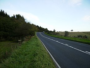
The road then heads mostly in a south easterly direction out of Whitby bisecting Low & High
Hawsker and then into open moorland again until it reaches the village of Cloughton where the National Park ends. It then heads due south through Burniston and Scalby before finishing in Scarborough at a
400:
The road starts on the A66 at
Middlesbrough (South Bank) and heads south east through Ormesby to Nunthorpe where it turns east as a dual carriageway bypassing Guisborough and the road becomes single carriageway again. Just outside Guisborough it heads into the
628:
429:
The route is served by Arriva bus service X93/X94. During the summer part of the timetable (which is the end of March to the start of
November) the service, for most of the day, is one bus every half hour in each direction.
405:
National Park (forming its boundary at first). As it passes the village of
Charltons, it rises up at a 15% incline through two 90° turns (the first east then the second south) up to Low Moor, this hill is named Birk Brow.
639:
1339:
1334:
413:
and down into Whitby where it heads across Whitby new bridge. The bridge was built in 1980 at a projected cost of £1 million but the final amount was closer to £2 million.
392:. Locally it is known as The Moor Road. The road is mostly single carriageway but has some sections of dual carriageway. The distance between the two towns is 47 miles (75 km)
213:
83:
601:
1467:
540:
441:
outside of Whitby in 2014. The park has space for 450 vehicles and buses run every 15 minutes to and from the town between the hours of 10 am and 7 pm.
1438:
775:
1353:
307:
48:
1462:
585:
498:
312:
785:
1431:
768:
389:
207:
548:
1472:
1457:
299:
1424:
761:
347:
332:
188:
179:
170:
161:
152:
143:
1296:
753:
197:
134:
868:
805:
716:
1281:
410:
664:
1118:
1108:
1103:
1098:
1073:
953:
928:
918:
908:
903:
888:
515:
462:
385:
1186:
873:
850:
845:
840:
835:
830:
825:
820:
815:
810:
743:
577:
571:
689:
738:
581:
494:
1408:
458:
402:
733:
369:
17:
409:
The road then wends its way through the open moorland of the North York Moors park past
470:
466:
273:
266:
541:"The New Bridge At Whitby - Real Whitby Forums - The Busiest Community Site In Whitby"
1451:
434:
373:
77:
377:
1400:
1321:
1316:
1311:
1306:
1301:
1291:
1286:
1276:
1271:
1266:
1261:
1256:
1251:
1246:
1241:
1236:
1231:
1226:
1221:
1216:
1211:
1206:
1201:
1196:
1191:
1181:
1176:
1171:
1166:
1161:
1156:
1151:
1146:
1141:
1136:
1131:
438:
1369:
1355:
229:
215:
99:
85:
1113:
1093:
1088:
1083:
1078:
1063:
1058:
1053:
1048:
1043:
1038:
1033:
1028:
1023:
1018:
1013:
1008:
1003:
998:
993:
988:
983:
978:
973:
968:
963:
958:
948:
943:
938:
933:
923:
913:
898:
893:
883:
878:
450:
37:
855:
728:
473:
at
Bannial Flat Farm just north of what is now the two A roads junction.
418:
795:
454:
365:
381:
280:
757:
1407:
This
England road or road transport-related article is a
545:
Real Whitby Forums - The
Busiest Community Site In Whitby
1412:
603:
290:
272:
262:
257:
203:
123:
73:
68:
60:
55:
34:
570:Armstrong, Judy; Bibby, Andrew (1 March 2006).
1432:
769:
437:facility was opened at the junction with the
8:
514:Somerville, Christopher (4 February 2006).
493:. Rough Guides. 1 April 2011. p. 224.
1439:
1425:
776:
762:
754:
638:. December 2009. p. 8. Archived from
629:"Whitby and Esk Valley Transport Strategy"
321:
1468:Transport in Scarborough, North Yorkshire
482:
457:aircraft shot down over England in the
665:"Park-and-ride scheme opens in Whitby"
31:
461:. Three Hawker Hurricane aircraft of
7:
1397:
1395:
573:Freedom to Roam The North York Moors
449:At the roundabout junction with the
786:Great Britain road numbering scheme
1411:. You can help Knowledge (XXG) by
25:
1399:
794:
342:
327:
192:
183:
174:
165:
156:
147:
138:
129:
64:48.1 mi (77.4 km)
47:
36:
576:. Frances Lincoln ltd. p.
1:
1463:Transport in North Yorkshire
690:"Heinkel He 111 near Whitby"
491:The Rough Guide to Yorkshire
241:A171 road (southeastern end)
111:A171 road (northwestern end)
744:GPX (secondary coordinates)
453:is a monument to the first
300:Roads in the United Kingdom
1489:
1394:
1340:List of B roads in Zone 1
1335:List of A roads in Zone 1
1330:
1127:
864:
801:
792:
784:A roads in Zone 1 of the
739:GPX (primary coordinates)
714:Map all coordinates using
320:
295:
286:
253:
46:
18:A171 road (Great Britain)
722:Download coordinates as:
694:yorkshire-aircraft.co.uk
734:GPX (all coordinates)
1365: /
645:on 24 November 2022
520:The Daily Telegraph
516:"Walk of the month"
421:on Falsgrave Road.
225: /
125:Major intersections
95: /
1473:England road stubs
1458:Roads in Yorkshire
1370:54.4712°N 0.7757°W
551:on 5 February 2015
417:junction with the
313:A and B road zones
230:54.2804°N 0.4053°W
100:54.5748°N 1.2033°W
1420:
1419:
1348:
1347:
636:northyorks.gov.uk
587:978-0-7112-2556-5
500:978-1-84836-603-9
358:
357:
354:
353:
56:Route information
16:(Redirected from
1480:
1441:
1434:
1427:
1403:
1396:
1389:
1388:
1386:
1385:
1384:
1382:
1377:
1376:
1375:54.4712; -0.7757
1371:
1366:
1363:
1362:
1361:
1358:
798:
778:
771:
764:
755:
705:
704:
702:
700:
686:
680:
679:
677:
675:
661:
655:
654:
652:
650:
644:
633:
625:
619:
618:
616:
614:
608:
598:
592:
591:
567:
561:
560:
558:
556:
547:. Archived from
537:
531:
530:
528:
526:
511:
505:
504:
487:
459:Second World War
403:North York Moors
386:Robin Hood's Bay
350:
346:
345:
335:
331:
330:
322:
249:
248:
246:
245:
244:
242:
237:
236:
235:54.2804; -0.4053
231:
226:
223:
222:
221:
218:
196:
195:
187:
186:
178:
177:
169:
168:
160:
159:
151:
150:
142:
141:
133:
132:
126:
119:
118:
116:
115:
114:
112:
107:
106:
105:54.5748; -1.2033
101:
96:
93:
92:
91:
88:
51:
40:
32:
21:
1488:
1487:
1483:
1482:
1481:
1479:
1478:
1477:
1448:
1447:
1446:
1445:
1392:
1380:
1378:
1374:
1372:
1368:
1367:
1364:
1359:
1356:
1354:
1352:
1351:
1349:
1344:
1326:
1123:
860:
799:
788:
782:
752:
751:
750:
749:
748:
709:
708:
698:
696:
688:
687:
683:
673:
671:
663:
662:
658:
648:
646:
642:
631:
627:
626:
622:
612:
610:
606:
600:
599:
595:
588:
569:
568:
564:
554:
552:
539:
538:
534:
524:
522:
513:
512:
508:
501:
489:
488:
484:
479:
447:
427:
398:
370:North Yorkshire
368:that links the
343:
341:
328:
326:
275:
240:
238:
234:
232:
228:
227:
224:
219:
216:
214:
212:
211:
210:
193:
191:
184:
182:
175:
173:
166:
164:
157:
155:
148:
146:
139:
137:
130:
124:
110:
108:
104:
102:
98:
97:
94:
89:
86:
84:
82:
81:
80:
69:Major junctions
41:
28:
27:Road in England
23:
22:
15:
12:
11:
5:
1486:
1484:
1476:
1475:
1470:
1465:
1460:
1450:
1449:
1444:
1443:
1436:
1429:
1421:
1418:
1417:
1404:
1346:
1345:
1343:
1342:
1337:
1331:
1328:
1327:
1325:
1324:
1319:
1314:
1309:
1304:
1299:
1294:
1289:
1284:
1279:
1274:
1269:
1264:
1259:
1254:
1249:
1244:
1239:
1234:
1229:
1224:
1219:
1214:
1209:
1204:
1199:
1194:
1189:
1184:
1179:
1174:
1169:
1164:
1159:
1154:
1149:
1144:
1139:
1134:
1128:
1125:
1124:
1122:
1121:
1116:
1111:
1106:
1101:
1096:
1091:
1086:
1081:
1076:
1071:
1066:
1061:
1056:
1051:
1046:
1041:
1036:
1031:
1026:
1021:
1016:
1011:
1006:
1001:
996:
991:
986:
981:
976:
971:
966:
961:
956:
951:
946:
941:
936:
931:
926:
921:
916:
911:
906:
901:
896:
891:
886:
881:
876:
871:
865:
862:
861:
859:
858:
853:
848:
843:
838:
833:
828:
823:
818:
813:
808:
802:
800:
793:
790:
789:
783:
781:
780:
773:
766:
758:
747:
746:
741:
736:
731:
725:
719:
712:
711:
710:
707:
706:
681:
656:
620:
593:
586:
562:
532:
506:
499:
481:
480:
478:
475:
471:Heinkel He 111
467:RAF Acklington
446:
443:
426:
423:
397:
394:
356:
355:
352:
351:
338:
336:
318:
317:
316:
315:
310:
304:
303:
293:
292:
288:
287:
284:
283:
278:
270:
269:
267:United Kingdom
264:
260:
259:
255:
254:
251:
250:
205:
204:South end
201:
200:
127:
121:
120:
75:
74:North end
71:
70:
66:
65:
62:
58:
57:
53:
52:
44:
43:
35:
26:
24:
14:
13:
10:
9:
6:
4:
3:
2:
1485:
1474:
1471:
1469:
1466:
1464:
1461:
1459:
1456:
1455:
1453:
1442:
1437:
1435:
1430:
1428:
1423:
1422:
1416:
1414:
1410:
1405:
1402:
1398:
1393:
1390:
1387:
1341:
1338:
1336:
1333:
1332:
1329:
1323:
1320:
1318:
1315:
1313:
1310:
1308:
1305:
1303:
1300:
1298:
1295:
1293:
1290:
1288:
1285:
1283:
1280:
1278:
1275:
1273:
1270:
1268:
1265:
1263:
1260:
1258:
1255:
1253:
1250:
1248:
1245:
1243:
1240:
1238:
1235:
1233:
1230:
1228:
1225:
1223:
1220:
1218:
1215:
1213:
1210:
1208:
1205:
1203:
1200:
1198:
1195:
1193:
1190:
1188:
1185:
1183:
1180:
1178:
1175:
1173:
1170:
1168:
1165:
1163:
1160:
1158:
1155:
1153:
1150:
1148:
1145:
1143:
1140:
1138:
1135:
1133:
1130:
1129:
1126:
1120:
1117:
1115:
1112:
1110:
1107:
1105:
1102:
1100:
1097:
1095:
1092:
1090:
1087:
1085:
1082:
1080:
1077:
1075:
1072:
1070:
1067:
1065:
1062:
1060:
1057:
1055:
1052:
1050:
1047:
1045:
1042:
1040:
1037:
1035:
1032:
1030:
1027:
1025:
1022:
1020:
1017:
1015:
1012:
1010:
1007:
1005:
1002:
1000:
997:
995:
992:
990:
987:
985:
982:
980:
977:
975:
972:
970:
967:
965:
962:
960:
957:
955:
952:
950:
947:
945:
942:
940:
937:
935:
932:
930:
927:
925:
922:
920:
917:
915:
912:
910:
907:
905:
902:
900:
897:
895:
892:
890:
887:
885:
882:
880:
877:
875:
872:
870:
867:
866:
863:
857:
854:
852:
849:
847:
844:
842:
839:
837:
834:
832:
829:
827:
824:
822:
819:
817:
814:
812:
809:
807:
804:
803:
797:
791:
787:
779:
774:
772:
767:
765:
760:
759:
756:
745:
742:
740:
737:
735:
732:
730:
727:
726:
724:
723:
718:
717:OpenStreetMap
715:
695:
691:
685:
682:
670:
666:
660:
657:
641:
637:
630:
624:
621:
605:
604:
597:
594:
589:
583:
579:
575:
574:
566:
563:
550:
546:
542:
536:
533:
521:
517:
510:
507:
502:
496:
492:
486:
483:
476:
474:
472:
468:
464:
460:
456:
452:
444:
442:
440:
436:
435:Park and Ride
431:
424:
422:
420:
414:
412:
407:
404:
395:
393:
391:
387:
383:
379:
375:
374:Middlesbrough
371:
367:
364:is a road in
363:
349:
339:
337:
334:
324:
323:
319:
314:
311:
309:
306:
305:
302:
301:
297:
296:
294:
289:
285:
282:
279:
277:
271:
268:
265:
261:
256:
252:
247:
209:
206:
202:
199:
190:
181:
172:
163:
154:
145:
136:
128:
122:
117:
79:
78:Middlesbrough
76:
72:
67:
63:
59:
54:
50:
45:
39:
33:
30:
19:
1413:expanding it
1406:
1391:
1350:
1068:
721:
720:
713:
697:. Retrieved
693:
684:
672:. Retrieved
668:
659:
647:. Retrieved
640:the original
635:
623:
611:. Retrieved
609:. Arriva Bus
602:
596:
572:
565:
553:. Retrieved
549:the original
544:
535:
523:. Retrieved
519:
509:
490:
485:
469:shot down a
448:
445:War monument
432:
428:
425:Bus services
415:
408:
399:
361:
359:
298:
291:Road network
276:destinations
29:
1373: /
463:43 Squadron
411:Scaling Dam
396:Description
390:Scarborough
378:Guisborough
233: /
208:Scarborough
103: /
1452:Categories
1379: (
1357:54°28′16″N
699:1 November
674:1 November
613:12 October
555:12 October
477:References
239: (
217:54°16′49″N
109: (
87:54°34′29″N
1381:A171 road
1360:0°46′33″W
649:2 October
525:22 August
372:towns of
308:Motorways
220:0°24′19″W
90:1°12′12″W
669:BBC News
258:Location
366:England
274:Primary
263:Country
584:
497:
455:German
382:Whitby
281:Whitby
61:Length
1322:A1500
1317:A1309
1312:A1307
1307:A1300
1302:A1237
1297:A1232
1292:A1231
1287:A1205
1282:A1202
1277:A1198
1272:A1175
1267:A1159
1262:A1156
1257:A1144
1252:A1136
1247:A1120
1242:A1107
1237:A1101
1232:A1098
1227:A1095
1222:A1094
1217:A1086
1212:A1085
1207:A1082
1202:A1081
1197:A1079
1192:A1078
1187:A1073
1182:A1071
1177:A1068
1172:A1067
1167:A1065
1162:A1058
1157:A1033
1152:A1031
1147:A1023
1142:A1018
1137:A1010
1132:A1000
643:(PDF)
632:(PDF)
607:(PDF)
439:B1460
1409:stub
1119:A197
1114:A194
1109:A186
1104:A183
1099:A180
1094:A179
1089:A178
1084:A174
1079:A173
1074:A172
1069:A171
1064:A170
1059:A169
1054:A168
1049:A167
1044:A166
1039:A165
1034:A160
1029:A158
1024:A156
1019:A153
1014:A152
1009:A151
1004:A149
999:A148
994:A146
989:A145
984:A144
979:A143
974:A142
969:A140
964:A135
959:A133
954:A132
949:A131
944:A130
939:A128
934:A127
929:A121
924:A120
919:A119
914:A118
909:A116
904:A114
899:A107
894:A105
889:A104
884:A103
879:A102
874:A101
869:A100
701:2015
676:2015
651:2018
615:2015
582:ISBN
557:2015
527:2019
495:ISBN
451:A169
388:and
362:A171
360:The
348:A172
333:A170
189:A170
180:A165
171:A174
162:A169
153:A173
144:A174
42:A171
856:A19
851:A18
846:A17
841:A16
836:A15
831:A14
826:A13
821:A12
816:A11
811:A10
729:KML
578:136
419:A64
198:A64
135:A66
1454::
806:A1
692:.
667:.
634:.
580:.
543:.
518:.
465:,
433:A
384:,
380:,
376:,
340:→
325:←
1440:e
1433:t
1426:v
1415:.
1383:)
777:e
770:t
763:v
703:.
678:.
653:.
617:.
590:.
559:.
529:.
503:.
243:)
113:)
20:)
Text is available under the Creative Commons Attribution-ShareAlike License. Additional terms may apply.