40:
351:
57:
378:
363:
402:
414:
90:
567:
390:
547:
97:
64:
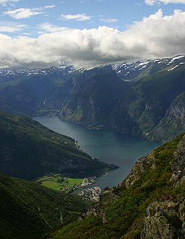
301:, Norway's longest fjord. The fjord is deep and narrow, reaching a depth of about 962 metres (3,156 ft) below sea level, and its width is generally less than 2 kilometres (1.2 mi) wide. About 11 kilometers (6.8 mi) south of the mouth of the fjord, the
317:. Most of the fjord is surrounded by up to 1,800-metre (5,900 ft) tall, steep mountains with little habitation along the fjord except for in a few small valleys.
350:
39:
608:
56:
362:
321:
377:
141:
652:
601:
89:
401:
413:
489:
627:
594:
551:
464:
438:
187:
632:
336:
647:
269:
257:
173:
642:
180:
578:
389:
637:
522:
332:
302:
310:
241:
201:
621:
309:
sits at the innermost part of the
Aurlandsfjord; other villages along the fjord are
566:
298:
194:
17:
369:
156:
143:
511:"Norwegian seiches from the giant 2011 Tohoku earthquake: NORWEGIAN SEICHES"
290:
294:
546:
574:
494:
314:
278:
125:
297:. The 29-kilometre (18 mi) long fjord is a branch off of the main
306:
286:
245:
174:
527:
510:
509:
Bondevik, Stein; Gjevik, Bjørn; Sørensen, Mathilde B. (16 July 2013).
188:
325:
282:
207:
274:
442:
465:"An earthquake in Japan caused large waves in Norwegian fjords"
324:
582:
237:
233:
225:
217:
213:
200:
186:
172:
133:
121:
32:
356:Aurlandsfjorden as seen from Aurland mountain road
305:branches off from it to the west. The village of
285:. The fjord flows through the municipalities of
134:
602:
331:Large parts of the fjord are included in the
8:
490:"Norway's weird waves traced to Japan quake"
335:section of the West Norwegian Fjords UNESCO
463:Union, American Geophysical (August 2013).
268:
609:
595:
29:
526:
430:
346:
96:
63:
7:
563:
561:
581:. You can help Knowledge (XXG) by
322:2011 Tōhoku earthquake and tsunami
25:
565:
545:
412:
400:
388:
376:
361:
349:
95:
88:
62:
55:
38:
488:Oskin, Becky (18 August 2013).
224:
216:
1:
120:
515:Geophysical Research Letters
383:The royal yacht at Skjerdal
669:
560:
368:Seen north-northwest from
229:962 metres (3,156 ft)
221:29 kilometres (18 mi)
270:[ˈæ̂ʉrlɑnsˌfjuːɳ]
49:
37:
27:Fjord in Vestland, Norway
653:Vestland geography stubs
419:Undredal seen from boat
76:Location of the village
577:location article is a
261:
109:Aurlandsfjord (Norway)
439:Store norske leksikon
266:Urban East Norwegian:
554:at Wikimedia Commons
79:Show map of Vestland
407:Cruise ship at Flåm
337:World Heritage Site
153: /
628:Fjords of Vestland
157:60.9155°N 7.1702°E
112:Show map of Norway
590:
589:
550:Media related to
528:10.1002/grl.50639
521:(13): 3374–3378.
443:"Aurlandsfjorden"
328:for a few hours.
251:
250:
44:View of the fjord
16:(Redirected from
660:
611:
604:
597:
569:
562:
549:
533:
532:
530:
506:
500:
499:
485:
479:
478:
476:
475:
460:
454:
453:
451:
450:
435:
416:
404:
392:
380:
365:
353:
272:
267:
190:
189:Primary outflows
176:
168:
167:
165:
164:
163:
158:
154:
151:
150:
149:
146:
136:
113:
99:
98:
92:
80:
66:
65:
59:
42:
30:
21:
668:
667:
663:
662:
661:
659:
658:
657:
618:
617:
616:
615:
558:
552:Aurlandsfjorden
542:
537:
536:
508:
507:
503:
487:
486:
482:
473:
471:
462:
461:
457:
448:
446:
437:
436:
432:
427:
420:
417:
408:
405:
396:
393:
384:
381:
372:
366:
357:
354:
345:
320:Tremors of the
265:
262:Aurlandsfjorden
204: countries
175:Primary inflows
162:60.9155; 7.1702
161:
159:
155:
152:
147:
144:
142:
140:
139:
128:
117:
116:
115:
114:
111:
110:
107:
106:
105:
104:
100:
83:
82:
81:
78:
77:
74:
73:
72:
71:
67:
45:
28:
23:
22:
18:Aurlandsfjorden
15:
12:
11:
5:
666:
664:
656:
655:
650:
645:
640:
635:
630:
620:
619:
614:
613:
606:
599:
591:
588:
587:
570:
556:
555:
541:
540:External links
538:
535:
534:
501:
480:
455:
445:(in Norwegian)
429:
428:
426:
423:
422:
421:
418:
411:
409:
406:
399:
397:
394:
387:
385:
382:
375:
373:
367:
360:
358:
355:
348:
344:
341:
311:Aurlandsvangen
249:
248:
242:Aurlandsvangen
239:
235:
234:
231:
230:
227:
223:
222:
219:
215:
214:
211:
210:
205:
198:
197:
192:
184:
183:
178:
170:
169:
137:
131:
130:
129:county, Norway
123:
119:
118:
108:
102:
101:
94:
93:
87:
86:
85:
84:
75:
69:
68:
61:
60:
54:
53:
52:
51:
50:
47:
46:
43:
35:
34:
26:
24:
14:
13:
10:
9:
6:
4:
3:
2:
665:
654:
651:
649:
646:
644:
641:
639:
636:
634:
631:
629:
626:
625:
623:
612:
607:
605:
600:
598:
593:
592:
586:
584:
580:
576:
571:
568:
564:
559:
553:
548:
544:
543:
539:
529:
524:
520:
516:
512:
505:
502:
497:
496:
491:
484:
481:
470:
466:
459:
456:
444:
440:
434:
431:
424:
415:
410:
403:
398:
391:
386:
379:
374:
371:
364:
359:
352:
347:
342:
340:
338:
334:
329:
327:
323:
318:
316:
312:
308:
304:
300:
296:
292:
288:
284:
280:
276:
271:
263:
259:
255:
254:Aurlandsfjord
247:
243:
240:
236:
232:
228:
226:Average depth
220:
212:
209:
206:
203:
199:
196:
193:
191:
185:
182:
179:
177:
171:
166:
138:
132:
127:
124:
103:Aurlandsfjord
91:
70:Aurlandsfjord
58:
48:
41:
36:
33:Aurlandsfjord
31:
19:
583:expanding it
572:
557:
518:
514:
504:
493:
483:
472:. Retrieved
468:
458:
447:. Retrieved
433:
330:
319:
299:Sognefjorden
253:
252:
195:Sognefjorden
181:Nærøyfjorden
238:Settlements
218:Max. length
160: /
135:Coordinates
633:Sognefjord
622:Categories
474:2022-04-16
449:2014-02-28
425:References
370:Stegastein
333:Nærøyfjord
303:Nærøyfjord
145:60°54′56″N
648:Vik, Sogn
258:Norwegian
148:7°10′13″E
575:Vestland
495:NBC News
469:phys.org
395:Panorama
315:Undredal
281:county,
279:Vestland
126:Vestland
122:Location
638:Aurland
343:Gallery
287:Aurland
273:) is a
643:Lærdal
295:Lærdal
293:, and
283:Norway
208:Norway
573:This
326:waves
275:fjord
202:Basin
579:stub
313:and
307:Flåm
246:Flåm
523:doi
291:Vik
277:in
624::
519:40
517:.
513:.
492:.
467:.
441:.
339:.
289:,
264:,
260::
244:,
610:e
603:t
596:v
585:.
531:.
525::
498:.
477:.
452:.
256:(
20:)
Text is available under the Creative Commons Attribution-ShareAlike License. Additional terms may apply.