370:
510:. There were 756 households, comprising 1,167 males and 1,122 females, giving a sex ratio of 1.04 males per female. The median age was 41.3 years (compared with 37.4 years nationally), with 486 people (21.2%) aged under 15 years, 396 (17.3%) aged 15 to 29, 1,059 (46.3%) aged 30 to 64, and 348 (15.2%) aged 65 or older.
550:
Of those at least 15 years old, 237 (13.1%) people had a bachelor's or higher degree, and 348 (19.3%) people had no formal qualifications. The median income was $ 34,200, compared with $ 31,800 nationally. 327 people (18.1%) earned over $ 70,000 compared to 17.2% nationally. The employment status of
422:
Of those at least 15 years old, 18 (8.2%) people had a bachelor's or higher degree, and 45 (20.5%) people had no formal qualifications. 42 people (19.2%) earned over $ 70,000 compared to 17.2% nationally. The employment status of those at least 15 was that 111 (50.7%) people were employed full-time,
298:. A private railway operated by the CHH Whakatane Mill used to run from Awakeri station to the mill at Whakatāne. The line (now closed and lifted) used to run alongside State Highway 30, including along the front of the petrol station forecourt at Awakeri.
389:. There were 96 households, comprising 153 males and 135 females, giving a sex ratio of 1.13 males per female, with 72 people (24.7%) aged under 15 years, 42 (14.4%) aged 15 to 29, 132 (45.4%) aged 30 to 64, and 42 (14.4%) aged 65 or older.
559:
Awakeri has a temperate climate, with warm summers and mild winters. The town is sheltered from the prevailing westerly winds by the surrounding hills, which helps to create a microclimate in the area.
1314:
1163:
809:
306:
Awakeri is in two SA1 statistical areas which cover 9.22 km (3.56 sq mi). The SA1 areas are part of the
Thornton-Awakeri statistical area.
435:, covers 151.84 km (58.63 sq mi) and had an estimated population of 2,540 as of June 2023, with a population density of 17 people per km.
231:. It is located in a farming and fruit-growing area, has basic amenities and a primary school for students aged 5 to 13, and is best known for nearby
48:
684:
628:
100:
1240:
275:
line also passes through the town, it was disused, however a tourist rail operator has recently leased a section of the branch line from
802:
755:
136:
258:
239:
141:
598:
551:
those at least 15 was that 942 (52.2%) people were employed full-time, 312 (17.3%) were part-time, and 63 (3.5%) were unemployed.
535:
Although some people chose not to answer the census's question about religious affiliation, 56.6% had no religion, 29.9% were
411:
Although some people chose not to answer the census's question about religious affiliation, 60.8% had no religion, 28.9% were
1281:
1214:
174:
795:
1194:
164:
576:
Awakeri School is a co-educational state primary school for Year 1 to 8 students, with a roll of 334 as of August 2024.
369:
1309:
536:
412:
1173:
1204:
689:
642:
288:
747:
1266:
1137:
921:
906:
777:
544:
522:
507:
503:
499:
432:
401:
386:
382:
378:
279:
and is opening a rail cart operation. Passenger train services ran through
Awakeri and were provided by the
128:
656:
660:
88:
1250:
1153:
835:
1209:
1199:
1178:
818:
787:
105:
1235:
1168:
1018:
901:
526:
405:
145:
1271:
1245:
1158:
1230:
1132:
540:
416:
1292:- formerly known as Edgecumbe-Tarawera Ward until 2010; - formerly a general ward until 2022
822:
284:
280:
269:
518:
397:
1303:
980:
224:
93:
568:
The
Awakeri Football Club is based at the school, with football the dominant sport.
1039:
701:
228:
1049:
947:
839:
514:
393:
220:
1276:
985:
826:
532:
The percentage of people born overseas was 8.7, compared with 27.1% nationally.
529:, and 0.9% other ethnicities. People may identify with more than one ethnicity.
408:, and 1.0% other ethnicities. People may identify with more than one ethnicity.
232:
1127:
990:
937:
769:
63:
50:
1054:
876:
243:
886:
702:"Awakeri: Exploring the Tranquil Charms of a Kiwi Town - New Zealand Govt"
1122:
1070:
1044:
975:
942:
911:
881:
276:
247:
729:
715:
1102:
1023:
995:
916:
896:
843:
452:
323:
295:
291:
272:
251:
970:
891:
368:
254:, and the two highways run together briefly through the village.
687:. Statistics New Zealand. March 2020. Thornton-Awakeri (202300).
791:
645:. New Zealand Ministry for Culture and Heritage. 6 August 2019.
447:
318:
631:. Statistics New Zealand. March 2020. 7015144 and 7015146.
423:
45 (20.5%) were part-time, and 6 (2.7%) were unemployed.
431:
Thornton-Awakeri statistical area, which also includes
748:"Awakeri School Ministry of Education School Profile"
1259:
1223:
1187:
1146:
1115:
1095:
1063:
1032:
1011:
1004:
963:
956:
930:
864:
857:
850:
206:
198:
193:
185:
180:
170:
160:
155:
127:
119:
111:
99:
87:
79:
26:
506:, and an increase of 273 people (13.5%) since the
498:Thornton-Awakeri had a population of 2,289 at the
1164:Te Paepae o Aotea (Volkner Rocks) Marine Reserve
679:
677:
385:, and an increase of 24 people (9.0%) since the
283:train from 1928 until 7 February 1959, when the
770:"Awakeri School Education Review Office Report"
310:Historical population for Awakeri and surrounds
261:gives a translation of "ditch" or "trench" for
803:
623:
621:
619:
502:, an increase of 174 people (8.2%) since the
377:The SA1 areas had a population of 291 at the
16:Locality in Bay of Plenty Region, New Zealand
8:
1315:Populated places in the Bay of Plenty Region
685:"Statistical area 1 dataset for 2018 Census"
629:"Statistical area 1 dataset for 2018 Census"
438:
381:, an increase of 12 people (4.3%) since the
309:
690:2018 Census place summary: Thornton-Awakeri
294:service that terminated before Awakeri, in
1092:
1008:
960:
861:
854:
810:
796:
788:
439:Historical population for Thornton-Awakeri
437:
308:
23:
250:and the route of SH 30 from Whakatāne to
730:"Awakeri School Official School Website"
585:
192:
179:
154:
126:
78:
43:
39:
657:"Population estimate tables - NZ.Stat"
593:
591:
589:
238:Awakeri is located at the junction of
21:Locality in Bay of Plenty, New Zealand
205:
197:
184:
169:
159:
118:
110:
98:
86:
7:
189:9.22 km (3.56 sq mi)
287:carriage train was replaced by an
219:is a village located southwest of
161: • Territorial authority
14:
427:Thornton-Awakeri statistical area
259:Ministry for Culture and Heritage
513:Ethnicities were 77.6% European/
392:Ethnicities were 87.6% European/
373:Droving sheep near Awakeri, 1924
1241:Te Whare Wānanga o Awanuiārangi
1174:Whakatane Board Mills Rail Line
1282:Whakatane Astronomical Society
734:awakeri.school.freeservers.com
547:and 1.2% had other religions.
419:and 3.1% had other religions.
175:Bay of Plenty Regional Council
1:
171: • Regional council
1012:Galatea-Waiohau Subdivision
1331:
1195:Whakatāne District Council
1147:Facilities and attractions
242:on the route of SH 2 from
165:Whakatāne District Council
1290:
833:
491:
465:—
362:
336:—
44:
40:
33:
1205:Kawerau District Council
643:"1000 Māori place names"
599:"ArcGIS Web Application"
227:region of New Zealand's
1267:Antipodes Water Company
1138:Whakaari / White Island
778:Education Review Office
752:educationcounts.govt.nz
716:"Awakeri Football Club"
603:statsnz.maps.arcgis.com
541:Māori religious beliefs
500:2018 New Zealand census
417:Māori religious beliefs
379:2018 New Zealand census
240:State Highways 2 and 30
115:Rangitāiki General Ward
1033:Te Urewera Subdivision
661:Statistics New Zealand
374:
1251:Whakatane High School
1154:Kawerau Power Station
1005:Galatea-Murupara C.B.
964:Taneatua-Waimana C.B.
756:Ministry of Education
372:
210:32/km (82/sq mi)
101:Territorial authority
1236:Tarawera High School
1159:Tāneatua Rail Branch
1064:Murupara Subdivision
931:Whakatāne-Ōhope Ward
207: • Density
123:Rangitāiki Community
1272:Radio Bay of Plenty
1246:Trident High School
1116:Geographic features
440:
311:
60: /
1310:Whakatane District
1179:Whakatāne Hospital
858:Whakatāne District
819:Whakatāne District
375:
199: • Total
186: • Total
106:Whakatāne District
64:38.000°S 176.900°E
1297:
1296:
1231:Edgecumbe College
1169:Whakatāne Airport
1133:Te Paepae o Aotea
1111:
1110:
1091:
1090:
1087:
1086:
1083:
1082:
1079:
1078:
496:
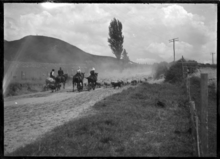
495:
367:
366:
214:
213:
1322:
1215:Regional Council
1096:Kawerau District
1093:
1009:
961:
862:
855:
851:Populated places
823:Kawerau District
812:
805:
798:
789:
782:
781:
766:
760:
759:
744:
738:
737:
726:
720:
719:
712:
706:
705:
698:
692:
688:
681:
672:
671:
669:
667:
653:
647:
646:
639:
633:
632:
625:
614:
613:
611:
609:
595:
454:
449:
441:
325:
320:
312:
281:Taneatua Express
257:The New Zealand
75:
74:
72:
71:
70:
69:-38.000; 176.900
65:
61:
58:
57:
56:
53:
24:
1330:
1329:
1325:
1324:
1323:
1321:
1320:
1319:
1300:
1299:
1298:
1293:
1286:
1255:
1219:
1200:Whakatāne Mayor
1183:
1142:
1107:
1075:
1059:
1028:
1000:
957:Te Urewera Ward
952:
926:
865:Rangitaiki Ward
846:
829:
816:
786:
785:
768:
767:
763:
746:
745:
741:
728:
727:
723:
714:
713:
709:
700:
699:
695:
683:
682:
675:
665:
663:
655:
654:
650:
641:
640:
636:
627:
626:
617:
607:
605:
597:
596:
587:
582:
574:
566:
557:
523:Pacific peoples
429:
402:Pacific peoples
304:
270:Taneatua Branch
151:
68:
66:
62:
59:
54:
51:
49:
47:
46:
36:
29:
22:
17:
12:
11:
5:
1328:
1326:
1318:
1317:
1312:
1302:
1301:
1295:
1294:
1291:
1288:
1287:
1285:
1284:
1279:
1274:
1269:
1263:
1261:
1257:
1256:
1254:
1253:
1248:
1243:
1238:
1233:
1227:
1225:
1221:
1220:
1218:
1217:
1212:
1207:
1202:
1197:
1191:
1189:
1185:
1184:
1182:
1181:
1176:
1171:
1166:
1161:
1156:
1150:
1148:
1144:
1143:
1141:
1140:
1135:
1130:
1125:
1119:
1117:
1113:
1112:
1109:
1108:
1106:
1105:
1099:
1097:
1089:
1088:
1085:
1084:
1081:
1080:
1077:
1076:
1074:
1073:
1067:
1065:
1061:
1060:
1058:
1057:
1052:
1047:
1042:
1036:
1034:
1030:
1029:
1027:
1026:
1021:
1015:
1013:
1006:
1002:
1001:
999:
998:
993:
988:
983:
978:
973:
967:
965:
958:
954:
953:
951:
950:
945:
940:
934:
932:
928:
927:
925:
924:
919:
914:
909:
904:
899:
894:
889:
884:
879:
874:
868:
866:
859:
852:
848:
847:
834:
831:
830:
817:
815:
814:
807:
800:
792:
784:
783:
761:
739:
721:
707:
693:
673:
648:
634:
615:
584:
583:
581:
578:
573:
570:
565:
562:
556:
553:
494:
493:
489:
488:
485:
482:
478:
477:
474:
471:
467:
466:
463:
460:
456:
455:
450:
445:
428:
425:
365:
364:
360:
359:
356:
353:
349:
348:
345:
342:
338:
337:
334:
331:
327:
326:
321:
316:
303:
300:
212:
211:
208:
204:
203:
200:
196:
195:
191:
190:
187:
183:
182:
178:
177:
172:
168:
167:
162:
158:
157:
153:
152:
150:
149:
139:
133:
131:
125:
124:
121:
117:
116:
113:
109:
108:
103:
97:
96:
91:
85:
84:
81:
77:
76:
42:
41:
38:
37:
34:
31:
30:
27:
20:
15:
13:
10:
9:
6:
4:
3:
2:
1327:
1316:
1313:
1311:
1308:
1307:
1305:
1289:
1283:
1280:
1278:
1275:
1273:
1270:
1268:
1265:
1264:
1262:
1260:Organisations
1258:
1252:
1249:
1247:
1244:
1242:
1239:
1237:
1234:
1232:
1229:
1228:
1226:
1222:
1216:
1213:
1211:
1210:Kawerau Mayor
1208:
1206:
1203:
1201:
1198:
1196:
1193:
1192:
1190:
1186:
1180:
1177:
1175:
1172:
1170:
1167:
1165:
1162:
1160:
1157:
1155:
1152:
1151:
1149:
1145:
1139:
1136:
1134:
1131:
1129:
1126:
1124:
1121:
1120:
1118:
1114:
1104:
1101:
1100:
1098:
1094:
1072:
1069:
1068:
1066:
1062:
1056:
1053:
1051:
1048:
1046:
1043:
1041:
1038:
1037:
1035:
1031:
1025:
1022:
1020:
1017:
1016:
1014:
1010:
1007:
1003:
997:
994:
992:
989:
987:
984:
982:
979:
977:
974:
972:
969:
968:
966:
962:
959:
955:
949:
946:
944:
941:
939:
936:
935:
933:
929:
923:
920:
918:
915:
913:
910:
908:
905:
903:
900:
898:
895:
893:
890:
888:
885:
883:
880:
878:
875:
873:
870:
869:
867:
863:
860:
856:
853:
849:
845:
841:
837:
832:
828:
824:
820:
813:
808:
806:
801:
799:
794:
793:
790:
779:
775:
771:
765:
762:
757:
753:
749:
743:
740:
735:
731:
725:
722:
717:
711:
708:
703:
697:
694:
691:
686:
680:
678:
674:
662:
658:
652:
649:
644:
638:
635:
630:
624:
622:
620:
616:
604:
600:
594:
592:
590:
586:
579:
577:
571:
569:
563:
561:
554:
552:
548:
546:
542:
538:
533:
530:
528:
524:
520:
516:
511:
509:
505:
501:
490:
486:
483:
480:
479:
475:
472:
469:
468:
464:
461:
458:
457:
451:
446:
443:
442:
436:
434:
426:
424:
420:
418:
414:
409:
407:
403:
399:
395:
390:
388:
384:
380:
371:
361:
357:
354:
351:
350:
346:
343:
340:
339:
335:
332:
329:
328:
322:
317:
314:
313:
307:
301:
299:
297:
293:
290:
286:
282:
278:
274:
271:
266:
264:
260:
255:
253:
249:
245:
241:
236:
234:
230:
226:
225:Bay of Plenty
222:
218:
209:
201:
188:
176:
173:
166:
163:
147:
143:
140:
138:
135:
134:
132:
130:
122:
114:
107:
104:
102:
95:
94:Bay of Plenty
92:
90:
82:
73:
45:Coordinates:
32:
25:
19:
1040:Maungapohatu
871:
773:
764:
751:
742:
733:
724:
710:
696:
664:. Retrieved
651:
637:
606:. Retrieved
602:
575:
567:
558:
549:
543:, 0.1% were
534:
531:
512:
497:
430:
421:
410:
391:
376:
305:
302:Demographics
285:steam-hauled
267:
262:
256:
237:
229:North Island
216:
215:
18:
1277:Tasman Mill
827:New Zealand
774:ero.govt.nz
539:, 4.8% had
508:2006 census
504:2013 census
415:, 1.0% had
387:2006 census
383:2013 census
233:hot springs
129:Electorates
83:New Zealand
67: /
1304:Categories
1188:Government
1128:Te Urewera
991:Te Urewera
938:Coastlands
666:25 October
580:References
194:Population
156:Government
137:East Coast
1224:Education
1055:Te Whaiti
1050:Ruatāhuna
948:Whakatāne
877:Edgecumbe
840:Whakatāne
608:8 January
572:Education
537:Christian
413:Christian
289:88-seater
244:Edgecumbe
221:Whakatāne
120:Community
1123:Putauaki
1071:Murupara
1045:Minginui
986:Tāneatua
976:Pekatahi
922:Thornton
912:Te Mahoe
907:Poroporo
882:Manawahe
545:Buddhist
517:, 34.2%
492:Source:
433:Thornton
396:, 22.7%
363:Source:
277:KiwiRail
248:Taneatua
142:Waiariki
55:176°54′E
35:Locality
1103:Kawerau
1024:Waiohau
1019:Galatea
996:Waimana
981:Ruatoki
917:Te Teko
897:Otakiri
872:Awakeri
844:Kawerau
555:Climate
525:, 1.6%
521:, 1.7%
453:±% p.a.
404:, 6.2%
400:, 2.1%
324:±% p.a.
296:Te Puke
292:railcar
273:railway
263:Awakeri
252:Te Teko
223:in the
217:Awakeri
80:Country
52:38°00′S
28:Awakeri
971:Matahi
887:Matatā
564:Sports
515:Pākehā
487:+1.59%
476:+0.69%
394:Pākehā
358:+0.85%
347:+0.63%
89:Region
943:Ōhope
902:Paroa
892:Onepu
836:Seats
527:Asian
519:Māori
484:2,289
473:2,115
462:2,016
406:Asian
398:Māori
146:Māori
821:and
668:2023
610:2023
481:2018
470:2013
459:2006
448:Pop.
444:Year
352:2018
341:2013
330:2006
319:Pop.
315:Year
268:The
181:Area
112:Ward
355:291
344:279
333:267
246:to
202:291
1306::
842:,
838::
825:,
776:.
772:.
754:.
750:.
732:.
676:^
659:.
618:^
601:.
588:^
265:.
235:.
811:e
804:t
797:v
780:.
758:.
736:.
718:.
704:.
670:.
612:.
148:)
144:(
Text is available under the Creative Commons Attribution-ShareAlike License. Additional terms may apply.