137:
213:
153:
177:
165:
189:
237:
201:
375:
31:
76:
to the south and the east
Jutland coast to the west. The bay stretches over an area of 610 square kilometres (240 sq mi) and consists of a flat bassin, increasing in depth from 14 m in the west to 18 m in the east. The bay mainly exchanges water with the
120:
park in the bay on the shallow reef of
Mejlflak between Tunø, Samsø and Helgenæs was initiated, scheduled to be completed in 2017. In September 2015, the project was put on hold indefinitely as it was not found profitable for energy company
152:
212:
164:
102:
136:
176:
416:
272:
85:
including
Norsminde Flak, Wulffs Flak, Mejlflak and Tunø Knob. These reefs, and the islands of Tunø and Samsø, prevents an open connection with the
236:
188:
450:
253:
200:
296:
409:
310:
440:
331:
81:
through a deep trench along Helgenæs with depths to 50 m. In the bay's southern section there are a number of stony
402:
284:
435:
170:
Sustainable fishing. Commercial fishing in the bay has almost vanished, due in part to ecological collapse.
98:
158:
The Bay of Aarhus rarely freezes up in winter, but some of the shallow coves do occasionally (Egens Vig).
445:
285:
Opgørelse af skadevirkninger på bundfaunaen efter iltsvindet i 2002 i de indre danske farvande
86:
386:
122:
223:
143:
429:
105:(DMU) in November 2002 and March 2003 showed large areas with noticeable damage to
110:
106:
65:
346:
333:
30:
374:
17:
117:
78:
69:
50:
382:
73:
64:
The Bay of Aarhus is bounded by Kalø Vig in the north, Sletterhage and
58:
47:
219:
54:
182:
Around the city of Aarhus, the coast has been secured from erosion.
29:
101:
with the Bay of Aarhus being hit especially hard. Studies by the
97:
In 2002, the inner Danish waters suffered serious and prolonged
82:
297:
Siemens skal bygge ultrabillige havvindmøller i
Aarhusbugten
142:
The Bay of Aarhus has several shallow coves (Egens Vig at
390:
242:
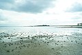
Sandy beaches form most of the coastline of the bay.
103:
311:"Omdiskuteret vindmøllepark på Mejlflak skrottes"
287:; Rapport nr. 456; 2003; DMU (Miljøministeriet)
410:
8:
417:
403:
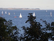
206:The bay is very popular for watersports.
265:
132:
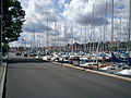
194:The port of Aarhus has heavy traffic.
113:and the western sections of the bay.
7:
371:
369:
389:. You can help Knowledge (XXG) by
299:; Ingeniøren.dk, 30 September 2014
116:In 2013, planning for an offshore
25:
309:Mortne Ravn (28 September 2017).
109:, especially around the areas of
373:
313:(in Danish). Århus Stiftstidende
235:
211:
199:
187:
175:
163:
151:
135:
1:
273:Aarhus Bugt, Den Store Danske
254:Tunø Knob Offshore Wind Farm
467:
368:
451:Denmark geography stubs
385:location article is a
35:
33:
218:The bay has several
93:Environmental issues
441:Geography of Aarhus
343: /
228:Aarhus Lystbådehavn
222:, with two in the
36:
398:
397:
16:(Redirected from
458:
419:
412:
405:
377:
370:
358:
357:
355:
354:
353:
348:
344:
341:
340:
339:
336:
323:
322:
320:
318:
306:
300:
294:
288:
282:
276:
270:
239:
215:
203:
191:
179:
167:
155:
139:
21:
466:
465:
461:
460:
459:
457:
456:
455:
436:Bays of Denmark
426:
425:
424:
423:
366:
364:
351:
349:
347:56.15°N 10.29°E
345:
342:
337:
334:
332:
330:
329:
327:
326:
316:
314:
308:
307:
303:
295:
291:
283:
279:
271:
267:
262:
250:
243:
240:
231:
216:
207:
204:
195:
192:
183:
180:
171:
168:
159:
156:
147:
140:
131:
95:
28:
23:
22:
15:
12:
11:
5:
464:
462:
454:
453:
448:
443:
438:
428:
427:
422:
421:
414:
407:
399:
396:
395:
378:
363:
362:External links
360:
325:
324:
301:
289:
277:
264:
263:
261:
258:
257:
256:
249:
246:
245:
244:
241:
234:
232:
224:port of Aarhus
217:
210:
208:
205:
198:
196:
193:
186:
184:
181:
174:
172:
169:
162:
160:
157:
150:
148:
141:
134:
130:
127:
94:
91:
27:Bay in Denmark
26:
24:
14:
13:
10:
9:
6:
4:
3:
2:
463:
452:
449:
447:
444:
442:
439:
437:
434:
433:
431:
420:
415:
413:
408:
406:
401:
400:
394:
392:
388:
384:
379:
376:
372:
367:
361:
359:
356:
312:
305:
302:
298:
293:
290:
286:
281:
278:
275:; Aarhus Bugt
274:
269:
266:
259:
255:
252:
251:
247:
238:
233:
229:
225:
221:
214:
209:
202:
197:
190:
185:
178:
173:
166:
161:
154:
149:
145:
138:
133:
128:
126:
124:
119:
114:
112:
108:
104:
100:
92:
90:
88:
84:
80:
75:
71:
68:in the east,
67:
62:
60:
56:
52:
49:
45:
41:
40:Bay of Aarhus
34:Bay of Aarhus
32:
19:
391:expanding it
380:
365:
352:56.15; 10.29
328:
315:. Retrieved
304:
292:
280:
268:
227:
115:
96:
63:
43:
39:
37:
350: /
317:13 December
144:Kalø Castle
107:marine life
57:in eastern
430:Categories
260:References
44:Aarhus Bay
18:Aarhus Bay
446:Kattegat
248:See also
118:windmill
111:Kalø Vig
87:Belt Sea
79:Kattegat
66:Helgenæs
51:waterway
338:10°17′E
335:56°09′N
226:alone (
220:marinas
129:Gallery
99:hypoxia
59:Jutland
46:, is a
383:Danish
55:Aarhus
48:Danish
381:This
83:reefs
70:Samsø
42:, or
387:stub
319:2017
123:NRGi
74:Tunø
72:and
38:The
53:by
432::
230:).
146:).
125:.
89:.
61:.
418:e
411:t
404:v
393:.
321:.
20:)
Text is available under the Creative Commons Attribution-ShareAlike License. Additional terms may apply.