40:
146:
246:), as well as for the wider marine and intertidal habitats of the area which support wintering wildfowl. The site has a number of graduated zones of saltmarsh, their composition and species dependent on the amount of tidal inundation and grazing. Fine muds predominate in the upper reaches of the three river estuaries; muddy sands are found in the midsections, and clean sand in the mouth of the estuary.
47:
473:
416:
498:
393:
63:
477:
424:
39:
160:
27:
94:
79:
176:
87:
493:
467:
447:
346:
338:
365:
354:
314:
258:
203:. The SSSI covers the tidal rivermouths of each of these; on the Tywi, north as far as the south of
377:
266:
145:
330:
230:
Aber Taf is listed as an SSSI for its saltmarsh vegetation, and for two sorts of migratory fish,
306:
134:
290:
250:
200:
282:
274:
168:
322:
188:
172:
73:
289:). Mid and upper marsh communities are composed of sea aster, common saltmarsh-grass,
487:
298:
224:
219:. The site extends across the saltflats of Carmarthen Bay, including Ginst Point,
239:
231:
220:
204:
196:
191:
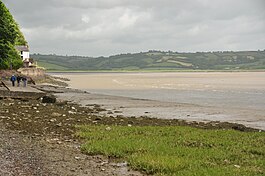
in the south-west of Wales. The estuary forms the mouth of three rivers - the
109:
96:
216:
212:
208:
192:
364:
The site is notable for occurrences of two other rare plant species, the
337:). Less grazed areas, such as Laugharne and Ginst Point have stands of
499:
Sites of
Special Scientific Interest in Carmarthen & Dinefwr
448:"Site of Special Scientific Interest, Carmarthenshire, Aber Taf"
394:
List of Sites of
Special Scientific Interest in Carmarthenshire
227:, and covers approximately 1,494.3 hectares (3,692 acres).
187:
Aber Taf is located in the central northern section of
133:
125:
86:
72:
62:
129:1,494.3 hectares (15 km; 5.8 sq mi)
249:The seaward fringe of the site is dominated by
8:
21:
16:Site of Special Scientific Interest in Wales
211:; on the Taf, to a point just north of the
442:
440:
438:
436:
434:
20:
215:and on the Gwendraeth as far east as the
144:
411:
409:
405:
223:Sands, Laughame Sands, East Marsh and
7:
161:Site of Special Scientific Interest
28:Site of Special Scientific Interest
417:"MAGIC Map Application - Aber Taf"
14:
46:
45:
38:
171:, Wales, and forms part of the
54:Location within Carmarthenshire
1:
177:Special Area of Conservation
515:
453:. Natural Resources Wales.
33:
26:
351:Bolboschoenus maritimus
343:Atriplex portulacoides
259:common saltmarsh-grass
149:
345:). Swampy areas have
207:, where it meets the
148:
359:Phragmites australis
319:Triglochin maritimum
263:Puccinellia maritima
110:51.72846°N 4.40403°W
382:Alopecurus bulbosus
331:English scurvygrass
271:Salicornia europaea
257:), with patches of
106: /
23:
494:Estuaries of Wales
335:Cochlearia anglica
150:
115:51.72846; -4.40403
370:Limonium procerum
366:rock sea-lavender
311:Plantago maritima
251:common cord-grass
143:
142:
506:
455:
454:
452:
444:
429:
428:
413:
305:) together with
295:Juncus maritimus
283:annual sea-blite
267:common glasswort
255:Spartina anglica
121:
120:
118:
117:
116:
111:
107:
104:
103:
102:
99:
82:
49:
48:
42:
24:
514:
513:
509:
508:
507:
505:
504:
503:
484:
483:
464:
459:
458:
450:
446:
445:
432:
421:DEFRA MAGIC Map
415:
414:
407:
402:
390:
378:bulbous foxtail
287:Suaeda maritima
279:Aster tripolium
185:
169:Carmarthenshire
114:
112:
108:
105:
100:
97:
95:
93:
92:
78:
68:Carmarthenshire
58:
57:
56:
55:
52:
51:
50:
17:
12:
11:
5:
512:
510:
502:
501:
496:
486:
485:
482:
481:
471:
463:
462:External links
460:
457:
456:
430:
404:
403:
401:
398:
397:
396:
389:
386:
327:Glaux maritima
315:sea arrowgrass
209:Afon Tywi SSSI
189:Carmarthen Bay
184:
181:
175:and Estuaries
173:Carmarthen Bay
141:
140:
137:
131:
130:
127:
123:
122:
90:
84:
83:
76:
74:Grid reference
70:
69:
66:
60:
59:
53:
44:
43:
37:
36:
35:
34:
31:
30:
15:
13:
10:
9:
6:
4:
3:
2:
511:
500:
497:
495:
492:
491:
489:
479:
475:
474:Aber Taf SSSI
472:
469:
468:SSSI Citation
466:
465:
461:
449:
443:
441:
439:
437:
435:
431:
426:
422:
418:
412:
410:
406:
399:
395:
392:
391:
387:
385:
383:
379:
375:
371:
367:
362:
360:
356:
352:
348:
347:sea club-rush
344:
340:
336:
332:
328:
324:
320:
316:
312:
308:
304:
303:Festuca rubra
300:
296:
292:
288:
284:
280:
276:
272:
268:
264:
260:
256:
252:
247:
245:
241:
237:
233:
228:
226:
225:Pendine Sands
222:
218:
214:
210:
206:
202:
198:
194:
190:
182:
180:
178:
174:
170:
166:
162:
159:) is a large
158:
154:
147:
138:
136:
132:
128:
124:
119:
91:
89:
85:
81:
77:
75:
71:
67:
65:
61:
41:
32:
29:
25:
19:
480:'s MAGIC Map
470:for Aber Taf
420:
381:
373:
369:
363:
358:
350:
342:
339:sea-purslane
334:
326:
323:sea-milkwort
318:
310:
307:sea plantain
302:
294:
286:
278:
270:
262:
254:
248:
244:Alosa fallax
243:
235:
229:
186:
164:
156:
152:
151:
135:Notification
18:
355:common reed
240:twaite shad
236:Alosa alosa
157:Taf Estuary
113: /
88:Coordinates
488:Categories
476:marked on
400:References
299:red fescue
232:allis shad
221:Cefn Sidan
205:Carmarthen
201:Gwendraeth
155:(English:
98:51°43′42″N
353:) or the
275:sea aster
217:A484 road
213:A477 road
101:4°24′15″W
388:See also
374:procerum
291:sea rush
153:Aber Taf
80:SN310110
64:Location
22:Aber Taf
376:) and
329:) and
297:) and
281:) and
238:) and
478:DEFRA
451:(PDF)
425:DEFRA
372:ssp.
167:) in
199:and
197:Tywi
183:SSSI
165:SSSI
139:2002
126:Area
384:).
361:).
321:),
313:),
273:),
265:),
193:Taf
490::
433:^
423:.
419:.
408:^
195:,
179:.
427:.
380:(
368:(
357:(
349:(
341:(
333:(
325:(
317:(
309:(
301:(
293:(
285:(
277:(
269:(
261:(
253:(
242:(
234:(
163:(
Text is available under the Creative Commons Attribution-ShareAlike License. Additional terms may apply.