288:
303:
45:
276:
114:
52:
263:
As of 2005, the municipality had a total population of 42,347 of whom 4,757 spoke an indigenous language. Agriculture includes cultivation of corn, rice, coffee, fruit and sugar cane. The woods are exploited for precious woods such as mahogany and cedar. Animal husbandry includes breeding pigs and
254:
Trees include Mulato, oak, pine, fig and fir. Fruits trees are soursop, pomegranate, nanche, tamarind, mango, avocado, orange, almond, guava, black sapote, sapodilla child, mamey sapote, sapodilla, banana and lemon. Wildlife includes badger, monkey, armadillo, wild boar, Zereth, tepexcuintle,
340:
302:
287:
76:
383:
332:
238:
The municipality covers an area of 933.9 km² at an altitude of 120 meters above sea level. The lower part is in the coastal plain of the
44:
126:
504:
453:
194:
173:
376:
275:
242:. Some of the hills rise to 300 meters. The climate is warm, with average temperature of 25 °C and variable rainfall. The
255:
raccoon, brocket deer, opossums, wild cat, skunk, rabbit, gopher, deer, oncillas, bobcat, coyote, squirrel and opossum.
428:
264:
cattle, and medium-scale poultry farming. The municipality has the "Ingenio La
Margarita" sugar processing facility.
448:
369:
443:
344:
485:
207:
30:
473:
227:
463:
468:
438:
243:
458:
183:
294:
393:
361:
223:
219:
433:
239:
498:
413:
423:
91:
78:
164:
418:
397:
215:
211:
131:
119:
308:
Ingenio Pablo
Machado Ll. "La Margarita" located in Vicente Camalote
190:
169:
341:
Instituto
Nacional para el Federalismo y el Desarrollo Municipal
365:
246:
in the south is used for water sports and sport fishing.
180:
163:
155:
150:
142:
137:
125:
107:
21:
51:
226:. The name "Acatlán" means "among the reeds".
377:
8:
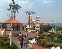
281:Centenario park in Acatlán de Pérez Figueroa
384:
370:
362:
18:
337:Enciclopedia de los Municipios de México
319:
271:
162:
149:
136:
106:
71:
37:
16:Municipality and town in Oaxaca, Mexico
327:
325:
323:
179:
154:
146:933.9 km (360.6 sq mi)
141:
124:
7:
293:Monument to the illustrious general
14:
454:San Juan Bautista Valle Nacional
301:
286:
274:
112:
50:
43:
1:
333:"Acatlán de Pérez Figueroa"
521:
449:San Juan Bautista Tuxtepec
482:
429:San Felipe Jalapa de Díaz
409:Acatlán de Pérez Figueroa
404:
204:Acatlán de Pérez Figueroa
72:
58:Acatlán de Pérez Figueroa
38:
28:
23:Acatlán de Pérez Figueroa
505:Municipalities of Oaxaca
486:Municipalities of Oaxaca
444:San José Independencia
474:Santa María Jacatepec
464:San Miguel Soyaltepec
218:. It is part of the
195:Central Daylight Time
182: • Summer (
174:Central Standard Time
295:Luis Perez Figueroa
228:Luis Pérez Figueroa
88: /
469:San Pedro Ixcatlán
439:San José Chiltepec
392:Municipalities of
244:Miguel Alemán Lake
156: • Total
143: • Total
64:Location in Mexico
492:
491:
459:San Lucas Ojitlán
394:Tuxtepec District
224:Papaloapan Region
220:Tuxtepec District
214:in south-western
201:
200:
92:18.533°N 96.600°W
512:
434:San Felipe Usila
386:
379:
372:
363:
356:
355:
353:
352:
343:. Archived from
329:
305:
290:
278:
187:
118:
116:
115:
103:
102:
100:
99:
98:
93:
89:
86:
85:
84:
81:
54:
53:
47:
19:
520:
519:
515:
514:
513:
511:
510:
509:
495:
494:
493:
488:
478:
400:
390:
360:
359:
350:
348:
331:
330:
321:
316:
309:
306:
297:
291:
282:
279:
270:
261:
252:
250:Flora and fauna
236:
230:was a general.
181:
113:
111:
97:18.533; -96.600
96:
94:
90:
87:
82:
79:
77:
75:
74:
68:
67:
66:
65:
62:
61:
60:
59:
55:
34:
24:
17:
12:
11:
5:
518:
516:
508:
507:
497:
496:
490:
489:
483:
480:
479:
477:
476:
471:
466:
461:
456:
451:
446:
441:
436:
431:
426:
421:
416:
411:
405:
402:
401:
391:
389:
388:
381:
374:
366:
358:
357:
318:
317:
315:
312:
311:
310:
307:
300:
298:
292:
285:
283:
280:
273:
269:
266:
260:
257:
251:
248:
240:Gulf of Mexico
235:
232:
206:is a town and
199:
198:
188:
178:
177:
167:
161:
160:
157:
153:
152:
148:
147:
144:
140:
139:
135:
134:
129:
123:
122:
109:
105:
104:
70:
69:
63:
57:
56:
49:
48:
42:
41:
40:
39:
36:
35:
29:
26:
25:
22:
15:
13:
10:
9:
6:
4:
3:
2:
517:
506:
503:
502:
500:
487:
481:
475:
472:
470:
467:
465:
462:
460:
457:
455:
452:
450:
447:
445:
442:
440:
437:
435:
432:
430:
427:
425:
422:
420:
417:
415:
412:
410:
407:
406:
403:
399:
395:
387:
382:
380:
375:
373:
368:
367:
364:
347:on 2007-09-30
346:
342:
338:
334:
328:
326:
324:
320:
313:
304:
299:
296:
289:
284:
277:
272:
267:
265:
258:
256:
249:
247:
245:
241:
233:
231:
229:
225:
221:
217:
213:
209:
205:
196:
192:
189:
185:
175:
171:
168:
166:
158:
145:
133:
130:
128:
121:
110:
101:
73:Coordinates:
46:
32:
27:
20:
414:Ayotzintepec
408:
349:. Retrieved
345:the original
336:
262:
253:
237:
208:municipality
203:
202:
31:Municipality
424:Loma Bonita
95: /
351:2010-07-26
314:References
151:Population
484:See also
234:Geography
165:Time zone
499:Category
419:Cosolapa
33:and town
268:Gallery
222:of the
108:Country
83:96°36′W
80:18°32′N
398:Oaxaca
259:People
216:Mexico
212:Oaxaca
159:42,347
132:Oaxaca
120:Mexico
117:
191:UTC-5
170:UTC-6
127:State
138:Area
210:in
184:DST
501::
396:,
339:.
335:.
322:^
385:e
378:t
371:v
354:.
197:)
193:(
186:)
176:)
172:(
Text is available under the Creative Commons Attribution-ShareAlike License. Additional terms may apply.