299:
314:
56:
287:
125:
63:
274:
As of 2005, the municipality had a total population of 42,347 of whom 4,757 spoke an indigenous language. Agriculture includes cultivation of corn, rice, coffee, fruit and sugar cane. The woods are exploited for precious woods such as mahogany and cedar. Animal husbandry includes breeding pigs and
265:
Trees include Mulato, oak, pine, fig and fir. Fruits trees are soursop, pomegranate, nanche, tamarind, mango, avocado, orange, almond, guava, black sapote, sapodilla child, mamey sapote, sapodilla, banana and lemon. Wildlife includes badger, monkey, armadillo, wild boar, Zereth, tepexcuintle,
351:
313:
298:
87:
394:
343:
249:
The municipality covers an area of 933.9 km² at an altitude of 120 meters above sea level. The lower part is in the coastal plain of the
55:
137:
515:
464:
205:
184:
387:
286:
253:. Some of the hills rise to 300 meters. The climate is warm, with average temperature of 25 °C and variable rainfall. The
266:
raccoon, brocket deer, opossums, wild cat, skunk, rabbit, gopher, deer, oncillas, bobcat, coyote, squirrel and opossum.
439:
275:
cattle, and medium-scale poultry farming. The municipality has the "Ingenio La
Margarita" sugar processing facility.
459:
380:
454:
355:
496:
218:
41:
484:
238:
474:
479:
449:
254:
469:
194:
305:
17:
404:
372:
234:
230:
444:
250:
509:
424:
434:
102:
89:
175:
429:
408:
226:
222:
142:
130:
319:
Ingenio Pablo
Machado Ll. "La Margarita" located in Vicente Camalote
201:
180:
352:
Instituto
Nacional para el Federalismo y el Desarrollo Municipal
376:
257:
in the south is used for water sports and sport fishing.
191:
174:
166:
161:
153:
148:
136:
118:
32:
62:
237:. The name "Acatlán" means "among the reeds".
388:
8:
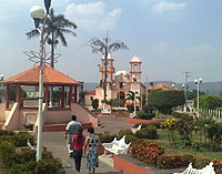
292:Centenario park in Acatlán de Pérez Figueroa
395:
381:
373:
29:
348:Enciclopedia de los Municipios de México
330:
282:
173:
160:
147:
117:
82:
48:
27:Municipality and town in Oaxaca, Mexico
338:
336:
334:
190:
165:
157:933.9 km (360.6 sq mi)
152:
135:
7:
304:Monument to the illustrious general
25:
18:Acatlán de Pérez Figueroa, Oaxaca
465:San Juan Bautista Valle Nacional
312:
297:
285:
123:
61:
54:
1:
344:"Acatlán de Pérez Figueroa"
532:
460:San Juan Bautista Tuxtepec
493:
440:San Felipe Jalapa de Díaz
420:Acatlán de Pérez Figueroa
415:
215:Acatlán de Pérez Figueroa
83:
69:Acatlán de Pérez Figueroa
49:
39:
34:Acatlán de Pérez Figueroa
516:Municipalities of Oaxaca
497:Municipalities of Oaxaca
455:San José Independencia
485:Santa María Jacatepec
475:San Miguel Soyaltepec
229:. It is part of the
206:Central Daylight Time
193: • Summer (
185:Central Standard Time
306:Luis Perez Figueroa
239:Luis Pérez Figueroa
99: /
480:San Pedro Ixcatlán
450:San José Chiltepec
403:Municipalities of
255:Miguel Alemán Lake
167: • Total
154: • Total
75:Location in Mexico
503:
502:
470:San Lucas Ojitlán
405:Tuxtepec District
235:Papaloapan Region
231:Tuxtepec District
225:in south-western
212:
211:
103:18.533°N 96.600°W
16:(Redirected from
523:
445:San Felipe Usila
397:
390:
383:
374:
367:
366:
364:
363:
354:. Archived from
340:
316:
301:
289:
198:
129:
127:
126:
114:
113:
111:
110:
109:
104:
100:
97:
96:
95:
92:
65:
64:
58:
30:
21:
531:
530:
526:
525:
524:
522:
521:
520:
506:
505:
504:
499:
489:
411:
401:
371:
370:
361:
359:
342:
341:
332:
327:
320:
317:
308:
302:
293:
290:
281:
272:
263:
261:Flora and fauna
247:
241:was a general.
192:
124:
122:
108:18.533; -96.600
107:
105:
101:
98:
93:
90:
88:
86:
85:
79:
78:
77:
76:
73:
72:
71:
70:
66:
45:
35:
28:
23:
22:
15:
12:
11:
5:
529:
527:
519:
518:
508:
507:
501:
500:
494:
491:
490:
488:
487:
482:
477:
472:
467:
462:
457:
452:
447:
442:
437:
432:
427:
422:
416:
413:
412:
402:
400:
399:
392:
385:
377:
369:
368:
329:
328:
326:
323:
322:
321:
318:
311:
309:
303:
296:
294:
291:
284:
280:
277:
271:
268:
262:
259:
251:Gulf of Mexico
246:
243:
217:is a town and
210:
209:
199:
189:
188:
178:
172:
171:
168:
164:
163:
159:
158:
155:
151:
150:
146:
145:
140:
134:
133:
120:
116:
115:
81:
80:
74:
68:
67:
60:
59:
53:
52:
51:
50:
47:
46:
40:
37:
36:
33:
26:
24:
14:
13:
10:
9:
6:
4:
3:
2:
528:
517:
514:
513:
511:
498:
492:
486:
483:
481:
478:
476:
473:
471:
468:
466:
463:
461:
458:
456:
453:
451:
448:
446:
443:
441:
438:
436:
433:
431:
428:
426:
423:
421:
418:
417:
414:
410:
406:
398:
393:
391:
386:
384:
379:
378:
375:
358:on 2007-09-30
357:
353:
349:
345:
339:
337:
335:
331:
324:
315:
310:
307:
300:
295:
288:
283:
278:
276:
269:
267:
260:
258:
256:
252:
244:
242:
240:
236:
232:
228:
224:
220:
216:
207:
203:
200:
196:
186:
182:
179:
177:
169:
156:
144:
141:
139:
132:
121:
112:
84:Coordinates:
57:
43:
38:
31:
19:
425:Ayotzintepec
419:
360:. Retrieved
356:the original
347:
273:
264:
248:
219:municipality
214:
213:
42:Municipality
435:Loma Bonita
106: /
362:2010-07-26
325:References
162:Population
495:See also
245:Geography
176:Time zone
510:Category
430:Cosolapa
44:and town
279:Gallery
233:of the
119:Country
94:96°36′W
91:18°32′N
409:Oaxaca
270:People
227:Mexico
223:Oaxaca
170:42,347
143:Oaxaca
131:Mexico
128:
202:UTC-5
181:UTC-6
138:State
149:Area
221:in
195:DST
512::
407:,
350:.
346:.
333:^
396:e
389:t
382:v
365:.
208:)
204:(
197:)
187:)
183:(
20:)
Text is available under the Creative Commons Attribution-ShareAlike License. Additional terms may apply.