362:
62:
95:
554:
386:
374:
45:
350:
102:
69:
329:
on the northern flank of a hill near castle Ter Horst. The castle was built in 1160 and demolished in 1528. In 1840, Achterberg was home to 1,043 people. In 1940, the village was the scene of heavy fighting during the
361:
614:
624:
595:
186:
61:
278:
44:
290:
130:
94:
500:
588:
323:
The village was first mentioned in 1417 as
Achterbergh, and means "(settlement) behind the hill". Achterberg developed as an
373:
270:
174:
385:
581:
331:
162:
492:
249:
259:
17:
561:
309:
179:
349:
496:
565:
619:
414:
553:
608:
465:
305:
167:
335:
317:
145:
132:
240:
523:
325:
313:
266:
245:
191:
338:
Crescendo was built in 1886 and destroyed in 1945 during a battle.
439:
49:
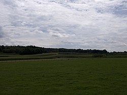
Corn fields in the direction of Rhenen, seen from
Achterberg
569:
289:
277:
256:
239:
231:
223:
218:
210:
202:
197:
185:
173:
161:
28:
589:
8:
491:Ronald Stenvert & Chris Kolman (1996).
596:
582:
25:
401:
345:
276:
238:
217:
209:
196:
160:
125:
53:
41:
615:Populated places in Utrecht (province)
409:
407:
405:
367:Former castle Ter Horst (16th century)
288:
255:
230:
222:
201:
184:
172:
7:
550:
548:
415:"Kerncijfers wijken en buurten 2021"
316:and it lies about 5 km west of
312:. It is part of the municipality of
206:0.38 km (0.15 sq mi)
625:Utrecht (province) geography stubs
568:. You can help Knowledge (XXG) by
466:"Achterberg - (geografische naam)"
101:
68:
14:
552:
384:
372:
360:
348:
100:
93:
67:
60:
43:
446:(in Dutch). Het Waterschapshuis
444:Actueel Hoogtebestand Nederland
23:Village in Utrecht, Netherlands
495:(in Dutch). Zwolle: Waanders.
84:Show map of Utrecht (province)
1:
419:Central Bureau of Statistics
235:4,400/km (11,000/sq mi)
81:Location in the Netherlands
641:
547:
16:For use as a surname, see
15:
440:"Postcodetool for 3911AA"
126:
54:
42:
35:
332:Battle of the Grebbeberg
114:Achterberg (Netherlands)
117:Show map of Netherlands
564:location article is a
214:15 m (49 ft)
258: • Summer (
379:Church of Achterberg
304:is a village in the
232: • Density
146:51.97167°N 5.58556°E
18:Achterberg (surname)
142: /
224: • Total
203: • Total
577:
576:
299:
298:
151:51.97167; 5.58556
632:
598:
591:
584:
556:
549:
540:
539:
537:
535:
520:
514:
513:
511:
509:
488:
482:
481:
479:
477:
462:
456:
455:
453:
451:
436:
430:
429:
427:
425:
411:
388:
376:
364:
355:Estate Stuivenes
352:
263:
157:
156:
154:
153:
152:
147:
143:
140:
139:
138:
135:
118:
104:
103:
97:
85:
71:
70:
64:
47:
26:
640:
639:
635:
634:
633:
631:
630:
629:
605:
604:
603:
602:
545:
543:
533:
531:
522:
521:
517:
507:
505:
503:
490:
489:
485:
475:
473:
464:
463:
459:
449:
447:
438:
437:
433:
423:
421:
413:
412:
403:
399:
392:
389:
380:
377:
368:
365:
356:
353:
344:
285:
257:
150:
148:
144:
141:
136:
133:
131:
129:
128:
122:
121:
120:
119:
116:
115:
112:
111:
110:
109:
105:
88:
87:
86:
83:
82:
79:
78:
77:
76:
72:
50:
38:
31:
24:
21:
12:
11:
5:
638:
636:
628:
627:
622:
617:
607:
606:
601:
600:
593:
586:
578:
575:
574:
557:
542:
541:
515:
501:
483:
470:Etymologiebank
457:
431:
400:
398:
395:
394:
393:
391:Railway bridge
390:
383:
381:
378:
371:
369:
366:
359:
357:
354:
347:
343:
340:
297:
296:
293:
287:
286:
283:
281:
275:
274:
264:
254:
253:
243:
237:
236:
233:
229:
228:
225:
221:
220:
216:
215:
212:
208:
207:
204:
200:
199:
195:
194:
189:
183:
182:
177:
171:
170:
165:
159:
158:
124:
123:
113:
107:
106:
99:
98:
92:
91:
90:
89:
80:
74:
73:
66:
65:
59:
58:
57:
56:
55:
52:
51:
48:
40:
39:
36:
33:
32:
29:
22:
13:
10:
9:
6:
4:
3:
2:
637:
626:
623:
621:
618:
616:
613:
612:
610:
599:
594:
592:
587:
585:
580:
579:
573:
571:
567:
563:
558:
555:
551:
546:
529:
525:
519:
516:
504:
502:90 400 9757 7
498:
494:
487:
484:
471:
467:
461:
458:
445:
441:
435:
432:
420:
416:
410:
408:
406:
402:
396:
387:
382:
375:
370:
363:
358:
351:
346:
341:
339:
337:
333:
328:
327:
321:
319:
315:
311:
307:
303:
294:
292:
282:
280:
272:
268:
265:
261:
251:
247:
244:
242:
234:
226:
213:
205:
193:
190:
188:
181:
178:
176:
169:
166:
164:
155:
127:Coordinates:
96:
63:
46:
34:
27:
19:
570:expanding it
559:
544:
532:. Retrieved
528:Plaatsengids
527:
524:"Achterberg"
518:
506:. Retrieved
493:"Achterberg"
486:
474:. Retrieved
469:
460:
448:. Retrieved
443:
434:
422:. Retrieved
418:
324:
322:
308:province of
301:
300:
291:Dialing code
187:Municipality
279:Postal code
168:Netherlands
149: /
609:Categories
530:(in Dutch)
472:(in Dutch)
397:References
336:grist mill
318:Wageningen
302:Achterberg
219:Population
134:51°58′18″N
108:Achterberg
75:Achterberg
30:Achterberg
241:Time zone
211:Elevation
534:27 March
508:26 March
476:27 March
450:27 March
424:27 March
175:Province
137:5°35′8″E
562:Utrecht
342:Gallery
310:Utrecht
180:Utrecht
163:Country
37:Village
620:Rhenen
499:
334:. The
326:esdorp
314:Rhenen
192:Rhenen
560:This
306:Dutch
267:UTC+2
246:UTC+1
227:1,670
566:stub
536:2022
510:2022
497:ISBN
478:2022
452:2022
426:2022
295:0317
284:3911
271:CEST
198:Area
260:DST
250:CET
611::
526:.
468:.
442:.
417:.
404:^
320:.
597:e
590:t
583:v
572:.
538:.
512:.
480:.
454:.
428:.
273:)
269:(
262:)
252:)
248:(
20:.
Text is available under the Creative Commons Attribution-ShareAlike License. Additional terms may apply.