56:
603:
1467:
68:
1322:
1339:
1314:
1297:
672:
who administers rural fire protection and ambulance service, provides relief to the poor, manages cemetery care, and performs farm assessment, among other duties. The trustee is assisted in these duties by a three-member township board. The trustees and board members are elected to four-year terms.
615:
The township contains three cemeteries. Mound (or Round) Cemetery is about 4 miles southeast of Pine
Village and is in the form of a mound about 30 feet (9.1 m) high; county roads 700 N and 600 E intersect here and form a circle around the mound. Harman Cemetery is less than a mile further to
55:
81:
1390:
1258:
1224:
1201:
1805:
657:
1800:
778:
1541:
1278:
1531:
1526:
1501:
1348:
1286:
1119:
927:
892:
857:
1536:
1506:
1491:
1353:
1328:
817:
677:
1511:
983:
1521:
1516:
1496:
1306:
1742:
1707:
1383:
957:
1009:
1687:
1110:
918:
883:
848:
278:
1251:
779:"Population, Housing Units, Area, and Density: 2010 - County – County Subdivision and Place – 2010 Census Summary File 1"
681:
241:
1376:
1115:
923:
888:
853:
730:
708:
573:
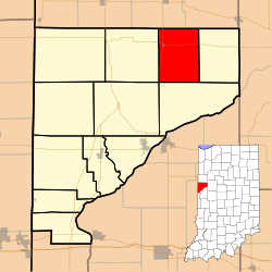
According to the 2010 census, the township has a total area of 26.99 square miles (69.9 km), all land. Its only town is
67:
1810:
1368:
1244:
782:
602:
135:
813:
637:
1712:
535:
520:
505:
490:
475:
460:
445:
430:
415:
400:
385:
370:
355:
340:
308:
1737:
1446:
669:
584:
296:
266:
167:
113:
46:
1105:
913:
878:
843:
755:
1722:
1551:
1236:
284:
1770:
1727:
1697:
1400:
588:
300:
140:
591:
to the north and passes just to the northwest of Pine
Village and continues southwest, emptying into the
1629:
1574:
1456:
1451:
1441:
1422:
629:
625:
574:
24:
1168:
1777:
685:
251:
987:
961:
1692:
1677:
1672:
1662:
1624:
1614:
1599:
1589:
1564:
578:
1747:
1657:
1579:
1218:
1195:
633:
1147:
561:
Adams
Township was formed in 1848 and was named after the sixth president of the United States,
1013:
632:, intersect in Pine Village; State Road 26 begins at the Illinois border and continues east to
1717:
1702:
1639:
1433:
562:
152:
1682:
1634:
1569:
1057:
1082:
1667:
1584:
1559:
660:. It contains one of the three elementary schools in the county, located in Pine Village.
645:
641:
596:
1732:
1594:
1478:
20:
1794:
271:
1604:
592:
1415:
1649:
123:
96:
83:
232:
1761:‡This populated place also has portions in an adjacent county or counties
1035:
821:
147:
1133:
581:
stood southeast of Pine
Village in the early part of the 20th century.
304:
128:
601:
577:
in the northwest part of the township, though a tiny hamlet named
258:
237:
1466:
1372:
1240:
616:
the southeast. Quaker
Cemetery is southwest of Chatterton.
311:, its population was 535 and it contained 243 housing units.
1465:
704:
1267:
Places adjacent to Adams
Township, Warren County, Indiana
1173:. Indianapolis: B. F. Bowen and Company. pp. 201–335
1170:
Past and
Present of Fountain and Warren Counties Indiana
1152:
Counties of Warren, Benton, Jasper and Newton, Indiana
1213:(175th Anniversary ed.). Williamsport, Indiana.
1154:. Chicago: F. A. Battey and Company. pp. 31–156
1756:
1648:
1613:
1550:
1477:
1432:
277:
265:
248:
231:
223:
215:
210:
202:
194:
186:
178:
173:
163:
158:
146:
134:
122:
112:
37:
1134:United States Census Bureau TIGER/Line Shapefiles
1012:. Indiana Department of Education. Archived from
1010:"Corporation Snapshot, M S D Warren County #8115"
803:Warren County Historical Society 1966, pp. 17–18.
1384:
1252:
947:Warren County Historical Society 1966, p. 21.
768:Warren County Historical Society 1966, p. 17.
658:Metropolitan School District of Warren County
8:
60:Location of Adams Township in Warren County
1391:
1377:
1369:
1259:
1245:
1237:
1223:: CS1 maint: location missing publisher (
1200:: CS1 maint: location missing publisher (
313:
34:
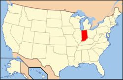
1470:Map of Indiana highlighting Warren County
1209:Warren County Historical Society (2002).
1186:Warren County Historical Society (1966).
1120:United States Department of the Interior
1106:"Adams Township, Warren County, Indiana"
1038:. United Township Association of Indiana
928:United States Department of the Interior
893:United States Department of the Interior
858:United States Department of the Interior
72:Location of Indiana in the United States
818:Indiana Department of Natural Resources
756:"Township Census Counts: STATS Indiana"
696:
276:
264:
230:
209:
201:
172:
157:
111:
76:
52:
1216:
1193:
781:. United States Census. Archived from
333:
247:
222:
214:
193:
185:
177:
162:
145:
133:
121:
64:
7:
1806:Populated places established in 1848
1274:
678:Indiana's 8th congressional district
644:to the south and continues north to
190:26.99 sq mi (69.9 km)
182:26.99 sq mi (69.9 km)
1801:Townships in Warren County, Indiana
1211:A History of Warren County, Indiana
1188:A History of Warren County, Indiana
1148:"Part II. History of Warren County"
1111:Geographic Names Information System
919:Geographic Names Information System
884:Geographic Names Information System
849:Geographic Names Information System
1399:Municipalities and communities of
986:. Highway Explorer. Archived from
960:. Highway Explorer. Archived from
640:, while State Road 55 enters from
323:
32:Township in Indiana, United States
16:Township in Indiana, United States
14:
1279:Oak Grove Township, Benton County
1337:
1320:
1312:
1295:
682:Indiana House of Representatives
66:
54:
1287:Bolivar Township, Benton County
1116:United States Geological Survey
924:United States Geological Survey
889:United States Geological Survey
854:United States Geological Survey
709:United States Geological Survey
705:"US Board on Geographic Names"
656:Adams Township is part of the
648:in neighboring Benton County.
1:
1338:
1296:
1167:Clifton, Thomas, ed. (1913).
1146:Goodspeed, Weston A. (1883).
198:0 sq mi (0 km)
1321:
1313:
550:Source: US Decennial Census
1827:
676:Adams Township is part of
18:
1766:
1463:
1413:
1272:
1083:"Indiana House Districts"
587:enters the township from
549:
534:
519:
504:
489:
474:
459:
444:
429:
414:
399:
384:
369:
354:
339:
332:
327:
322:
319:
77:
65:
53:
44:
1190:. Williamsport, Indiana.
206:722 ft (220 m)
19:Not to be confused with
1471:
1402:Warren County, Indiana
607:
227:20/sq mi (7.7/km)
1469:
731:"Explore Census Data"
668:Adams Township has a
630:Indiana State Road 55
626:Indiana State Road 26
606:Map of Adams Township
605:
315:Historical population
250: • Summer (
97:40.44111°N 87.24472°W
25:Adams County, Indiana
1811:Townships in Indiana
1779:United States portal
785:on February 12, 2020
686:Indiana State Senate
224: • Density
824:on October 15, 2010
316:
307:. According to the
102:40.44111; -87.24472
93: /
1472:
1088:. State of Indiana
1063:. State of Indiana
964:on October 7, 2011
711:. October 25, 2007
608:
314:
216: • Total
195: • Water
179: • Total
1788:
1787:
1366:
1365:
1361:
1360:
914:"Quaker Cemetery"
879:"Harman Cemetery"
684:District 26, and
638:Tippecanoe County
563:John Quincy Adams
554:
553:
295:is one of twelve
290:
289:
187: • Land
164: • Type
153:John Quincy Adams
1818:
1780:
1773:
1713:Mudlavia Springs
1468:
1425:
1418:
1408:
1403:
1393:
1386:
1379:
1370:
1349:Liberty Township
1341:
1340:
1324:
1323:
1316:
1315:
1299:
1298:
1275:
1261:
1254:
1247:
1238:
1228:
1222:
1214:
1205:
1199:
1191:
1182:
1180:
1178:
1163:
1161:
1159:
1130:
1128:
1126:
1098:
1097:
1095:
1093:
1087:
1079:
1073:
1072:
1070:
1068:
1062:
1058:"Indiana Senate"
1054:
1048:
1047:
1045:
1043:
1032:
1026:
1025:
1023:
1021:
1006:
1000:
999:
997:
995:
990:on July 11, 2011
980:
974:
973:
971:
969:
954:
948:
945:
939:
938:
936:
934:
910:
904:
903:
901:
899:
875:
869:
868:
866:
864:
844:"Mound Cemetery"
840:
834:
833:
831:
829:
820:. Archived from
814:"Big Pine Creek"
810:
804:
801:
795:
794:
792:
790:
775:
769:
766:
760:
759:
752:
746:
745:
743:
741:
727:
721:
720:
718:
716:
701:
335:
330:
325:
317:
255:
168:Indiana township
108:
107:
105:
104:
103:
98:
94:
91:
90:
89:
86:
70:
58:
35:
1826:
1825:
1821:
1820:
1819:
1817:
1816:
1815:
1791:
1790:
1789:
1784:
1778:
1771:
1762:
1752:
1738:Sycamore Corner
1644:
1616:
1609:
1546:
1473:
1461:
1447:State Line City
1428:
1423:
1416:
1409:
1406:
1401:
1397:
1367:
1362:
1354:Warren Township
1329:Medina Township
1325:
1283:
1268:
1265:
1235:
1215:
1208:
1192:
1185:
1176:
1174:
1166:
1157:
1155:
1145:
1142:
1124:
1122:
1104:
1101:
1091:
1089:
1085:
1081:
1080:
1076:
1066:
1064:
1060:
1056:
1055:
1051:
1041:
1039:
1034:
1033:
1029:
1019:
1017:
1016:on July 6, 2002
1008:
1007:
1003:
993:
991:
984:"State Road 55"
982:
981:
977:
967:
965:
958:"State Road 26"
956:
955:
951:
946:
942:
932:
930:
912:
911:
907:
897:
895:
877:
876:
872:
862:
860:
842:
841:
837:
827:
825:
812:
811:
807:
802:
798:
788:
786:
777:
776:
772:
767:
763:
754:
753:
749:
739:
737:
735:data.census.gov
729:
728:
724:
714:
712:
703:
702:
698:
694:
666:
654:
622:
613:
571:
559:
328:
249:
101:
99:
95:
92:
87:
84:
82:
80:
79:
73:
61:
49:
40:
33:
28:
17:
12:
11:
5:
1824:
1822:
1814:
1813:
1808:
1803:
1793:
1792:
1786:
1785:
1783:
1782:
1775:
1772:Indiana portal
1767:
1764:
1763:
1760:
1758:
1754:
1753:
1751:
1750:
1745:
1740:
1735:
1730:
1725:
1723:Point Pleasant
1720:
1715:
1710:
1705:
1700:
1695:
1690:
1685:
1680:
1675:
1670:
1665:
1660:
1654:
1652:
1646:
1645:
1643:
1642:
1637:
1632:
1627:
1621:
1619:
1611:
1610:
1608:
1607:
1602:
1597:
1592:
1587:
1582:
1577:
1572:
1567:
1562:
1556:
1554:
1548:
1547:
1545:
1544:
1539:
1534:
1529:
1524:
1519:
1514:
1509:
1504:
1499:
1494:
1489:
1483:
1481:
1475:
1474:
1464:
1462:
1460:
1459:
1454:
1449:
1444:
1438:
1436:
1430:
1429:
1414:
1411:
1410:
1398:
1396:
1395:
1388:
1381:
1373:
1364:
1363:
1359:
1358:
1356:
1351:
1345:
1344:
1342:
1335:
1332:
1331:
1326:
1318:Adams Township
1311:
1309:
1303:
1302:
1300:
1293:
1290:
1289:
1284:
1281:
1273:
1270:
1269:
1266:
1264:
1263:
1256:
1249:
1241:
1234:
1233:External links
1231:
1230:
1229:
1206:
1183:
1164:
1141:
1138:
1137:
1136:
1131:
1100:
1099:
1074:
1049:
1027:
1001:
975:
949:
940:
905:
870:
835:
805:
796:
770:
761:
747:
722:
695:
693:
690:
665:
662:
653:
650:
624:Two highways,
621:
620:Transportation
618:
612:
609:
585:Big Pine Creek
570:
567:
558:
555:
552:
551:
547:
546:
543:
541:
538:
532:
531:
528:
526:
523:
517:
516:
513:
511:
508:
502:
501:
498:
496:
493:
487:
486:
483:
481:
478:
472:
471:
468:
466:
463:
457:
456:
453:
451:
448:
442:
441:
438:
436:
433:
427:
426:
423:
421:
418:
412:
411:
408:
406:
403:
397:
396:
393:
391:
388:
382:
381:
378:
376:
373:
367:
366:
363:
361:
358:
352:
351:
348:
346:
343:
337:
336:
331:
326:
321:
293:Adams Township
288:
287:
282:
275:
274:
269:
263:
262:
256:
246:
245:
235:
229:
228:
225:
221:
220:
217:
213:
212:
208:
207:
204:
200:
199:
196:
192:
191:
188:
184:
183:
180:
176:
175:
171:
170:
165:
161:
160:
156:
155:
150:
144:
143:
138:
132:
131:
126:
120:
119:
116:
110:
109:
75:
74:
71:
63:
62:
59:
51:
50:
45:
42:
41:
39:Adams Township
38:
31:
21:Adams, Indiana
15:
13:
10:
9:
6:
4:
3:
2:
1823:
1812:
1809:
1807:
1804:
1802:
1799:
1798:
1796:
1781:
1776:
1774:
1769:
1768:
1765:
1759:
1755:
1749:
1746:
1744:
1741:
1739:
1736:
1734:
1731:
1729:
1728:Romine Corner
1726:
1724:
1721:
1719:
1716:
1714:
1711:
1709:
1706:
1704:
1701:
1699:
1698:Hooker Corner
1696:
1694:
1691:
1689:
1686:
1684:
1681:
1679:
1676:
1674:
1671:
1669:
1666:
1664:
1661:
1659:
1656:
1655:
1653:
1651:
1647:
1641:
1638:
1636:
1633:
1631:
1628:
1626:
1623:
1622:
1620:
1618:
1612:
1606:
1603:
1601:
1598:
1596:
1593:
1591:
1588:
1586:
1583:
1581:
1578:
1576:
1573:
1571:
1568:
1566:
1563:
1561:
1558:
1557:
1555:
1553:
1549:
1543:
1540:
1538:
1535:
1533:
1530:
1528:
1525:
1523:
1520:
1518:
1515:
1513:
1510:
1508:
1505:
1503:
1500:
1498:
1495:
1493:
1490:
1488:
1485:
1484:
1482:
1480:
1476:
1458:
1455:
1453:
1450:
1448:
1445:
1443:
1440:
1439:
1437:
1435:
1431:
1427:
1426:
1419:
1412:
1407:United States
1404:
1394:
1389:
1387:
1382:
1380:
1375:
1374:
1371:
1357:
1355:
1352:
1350:
1347:
1346:
1343:
1336:
1334:
1333:
1330:
1327:
1319:
1310:
1308:
1307:Pine Township
1305:
1304:
1301:
1294:
1292:
1291:
1288:
1285:
1282:
1280:
1277:
1276:
1271:
1262:
1257:
1255:
1250:
1248:
1243:
1242:
1239:
1232:
1226:
1220:
1212:
1207:
1203:
1197:
1189:
1184:
1177:September 19,
1172:
1171:
1165:
1158:September 19,
1153:
1149:
1144:
1143:
1139:
1135:
1132:
1125:September 24,
1121:
1117:
1113:
1112:
1107:
1103:
1102:
1084:
1078:
1075:
1059:
1053:
1050:
1037:
1031:
1028:
1015:
1011:
1005:
1002:
994:September 21,
989:
985:
979:
976:
968:September 21,
963:
959:
953:
950:
944:
941:
929:
925:
921:
920:
915:
909:
906:
894:
890:
886:
885:
880:
874:
871:
859:
855:
851:
850:
845:
839:
836:
823:
819:
815:
809:
806:
800:
797:
784:
780:
774:
771:
765:
762:
757:
751:
748:
736:
732:
726:
723:
710:
706:
700:
697:
691:
689:
688:District 38.
687:
683:
679:
674:
671:
663:
661:
659:
651:
649:
647:
643:
639:
635:
631:
627:
619:
617:
610:
604:
600:
598:
594:
590:
589:Benton County
586:
582:
580:
576:
568:
566:
564:
556:
548:
544:
542:
539:
537:
533:
529:
527:
524:
522:
518:
514:
512:
509:
507:
503:
499:
497:
494:
492:
488:
484:
482:
479:
477:
473:
469:
467:
464:
462:
458:
454:
452:
449:
447:
443:
439:
437:
434:
432:
428:
424:
422:
419:
417:
413:
409:
407:
404:
402:
398:
394:
392:
389:
387:
383:
379:
377:
374:
372:
368:
364:
362:
359:
357:
353:
349:
347:
344:
342:
338:
318:
312:
310:
306:
302:
301:Warren County
298:
294:
286:
283:
280:
273:
270:
268:
260:
257:
253:
243:
242:Eastern (EST)
239:
236:
234:
226:
218:
205:
197:
189:
181:
169:
166:
154:
151:
149:
142:
139:
137:
130:
127:
125:
118:United States
117:
115:
106:
78:Coordinates:
69:
57:
48:
43:
36:
30:
26:
22:
1743:Walnut Grove
1708:Locust Grove
1630:Johnsonville
1575:Independence
1486:
1457:Williamsport
1452:West Lebanon
1442:Pine Village
1424:Williamsport
1421:
1317:
1210:
1187:
1175:. Retrieved
1169:
1156:. Retrieved
1151:
1140:Bibliography
1123:. Retrieved
1109:
1090:. Retrieved
1077:
1065:. Retrieved
1052:
1040:. Retrieved
1036:"Government"
1030:
1018:. Retrieved
1014:the original
1004:
992:. Retrieved
988:the original
978:
966:. Retrieved
962:the original
952:
943:
931:. Retrieved
917:
908:
896:. Retrieved
882:
873:
861:. Retrieved
847:
838:
826:. Retrieved
822:the original
808:
799:
787:. Retrieved
783:the original
773:
764:
750:
738:. Retrieved
734:
725:
713:. Retrieved
699:
675:
667:
655:
623:
614:
593:Wabash River
583:
575:Pine Village
572:
560:
292:
291:
29:
1688:Five Points
1650:Ghost towns
1617:communities
1417:County seat
1092:December 2,
1067:December 2,
1020:January 27,
933:January 27,
898:January 27,
863:January 27,
828:October 30,
309:2020 census
100: /
1795:Categories
1693:Glen Cliff
1678:Chesapeake
1673:Chatterton
1663:Black Rock
1625:Carbondale
1600:Rainsville
1590:Marshfield
1565:Green Hill
1542:Washington
1042:January 6,
692:References
664:Government
611:Cemeteries
579:Chatterton
281:feature ID
211:Population
159:Government
88:87°14′41″W
85:40°26′28″N
1757:Footnotes
1748:Warrenton
1658:Baltimore
1580:Judyville
1479:Townships
1219:cite book
1196:cite book
740:April 14,
652:Education
634:Lafayette
569:Geography
297:townships
267:Area code
233:Time zone
203:Elevation
148:Named for
1718:Old Town
1703:Kickapoo
1640:Winthrop
47:Township
1683:Dresser
1635:Stewart
1570:Hedrick
1532:Steuben
1527:Prairie
1502:Liberty
789:May 10,
670:trustee
557:History
305:Indiana
129:Indiana
114:Country
1668:Brisco
1585:Kramer
1560:Foster
1537:Warren
1507:Medina
1492:Jordan
715:May 9,
646:Oxford
642:Attica
597:Attica
500:−14.7%
485:−14.9%
320:Census
285:453082
141:Warren
136:County
1733:Sloan
1615:Other
1595:Pence
1512:Mound
1487:Adams
1434:Towns
1086:(PDF)
1061:(PDF)
595:near
530:−8.7%
515:13.8%
470:−4.6%
455:−8.7%
425:−2.4%
410:−7.2%
395:−9.1%
365:12.8%
261:(EDT)
259:UTC-4
238:UTC-5
124:State
1552:CDPs
1522:Pine
1517:Pike
1497:Kent
1225:link
1202:link
1179:2010
1160:2010
1127:2009
1094:2013
1069:2013
1044:2011
1022:2011
996:2010
970:2010
935:2011
900:2011
865:2011
830:2010
791:2013
742:2024
717:2017
628:and
545:4.5%
536:2020
521:2010
506:2000
491:1990
476:1980
461:1970
446:1960
440:0.3%
431:1950
416:1940
401:1930
386:1920
380:5.8%
371:1910
356:1900
341:1890
329:Note
324:Pop.
279:GNIS
174:Area
1605:Tab
636:in
540:535
525:512
510:561
495:493
480:578
465:679
450:712
435:780
420:778
405:797
390:859
375:945
360:893
345:792
299:in
272:765
252:DST
219:535
23:or
1797::
1420::
1405:,
1221:}}
1217:{{
1198:}}
1194:{{
1150:.
1118:,
1114:.
1108:.
926:,
922:.
916:.
891:,
887:.
881:.
856:,
852:.
846:.
816:.
733:.
707:.
680:,
599:.
565:.
334:%±
303:,
1392:e
1385:t
1378:v
1260:e
1253:t
1246:v
1227:)
1204:)
1181:.
1162:.
1129:.
1096:.
1071:.
1046:.
1024:.
998:.
972:.
937:.
902:.
867:.
832:.
793:.
758:.
744:.
719:.
350:—
254:)
244:)
240:(
27:.
Text is available under the Creative Commons Attribution-ShareAlike License. Additional terms may apply.