141:
95:
316:
373:
111:
358:
343:
331:
187:, an administrative division of Mauritania, is named after the traditional region. It is sometimes called Adrar Tamar to distinguish it from other areas called Adrar in the Sahara.
517:
246:, an uplifted and then heavily eroded dome of strata approximately 40 km across and whose concentric rings resemble an impact crater when observed from space.
227:, then loses elevation and becomes subsumed by dunes to the south and east. Limited cultivation is only possible in the gorges at lower elevations such like
234:
Features include the Oued el Abiod or 'White Valley', a dune-filled fault line along which many small settlements and palm groves are found. The Guelb
527:
94:
372:
315:
532:
414:
110:
507:
357:
40:
537:
512:
446:
330:
389:
522:
32:
27:
This article is about the natural and historical region of
Mauritania. For the administrative region, see
140:
342:
258:
487:
239:
172:
442:
250:
243:
235:
216:
164:
204:
156:
100:
300:
Beginning in the mid-17th century, migrants from the Adrar
Plateau region moved into the
301:
278:
228:
168:
501:
176:
290:
220:
184:
28:
492:
286:
238:
is 3.1 million-old impact crater which was studied by the noted
Saharan scholar
262:
249:
The Adrar region is home to a small human population, centered on the town of
224:
180:
124:
55:
42:
17:
363:
274:
215:
which rises to over 700 m (2,297 ft) above sea level just east of
208:
261:
and gold-trading centre, is located towards the eastern edge of the Adrar.
145:
467:
Desert
Frontier: Ecological and Economic Change Along the Western Sahel
294:
254:
196:
277:
era as shown by cave and rock paintings found in the area such as the
482:
231:, where the water table is high enough to support large palm groves.
212:
200:
483:
UNESCO: "Ancient Ksour of
Ouadane, Chinguetti, Tichitt and Oualata"
349:
321:
139:
282:
378:
A postbox in the airport of Atar, the Adrar's main town
265:
is another important historical town in the region.
130:
120:
75:
293:, e.g. Atar Stone Circle, and the later town of
242:. To the east beyond Ouadane is the distinctive
8:
518:Geologic formations with imbedded sand dunes
437:
435:
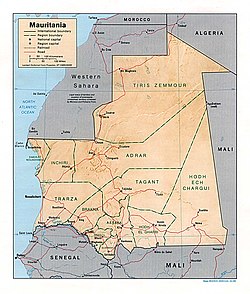
115:Location of the Adrar in central Mauritania
324:design on the hand of a girl of the region
211:. Structurally the Adrar is a low central
72:
409:
407:
405:
401:
311:
129:
119:
107:
99:Landscape of the stony desert known as
91:
304:and displaced the native population.
7:
421:. Brill Online Reference. July 2008
160:
144:Oblique view of Adrar Plateau from
25:
371:
356:
341:
329:
314:
109:
93:
336:A sandy area west of Chinguetti
167:for "mountain") is a highland
1:
528:Geologic formations of Africa
493:Map of the Adrar - Bab Sahara
289:intact, most notable several
273:The Adrar was settled in the
419:Encyclopedia of Islam, THREE
70:Natural region in Mauritania
443:"Adrar plateau, Mauritania"
554:
134:340 m (1,120 ft)
26:
533:Natural regions of Africa
488:The Adrar - Lonely Planet
108:
92:
85:
257:, formerly an important
508:Landforms of Mauritania
447:Encyclopædia Britannica
390:Geography of Mauritania
253:. The ancient town of
148:
33:Adrar (disambiguation)
31:. For other uses, see
415:"Adrar of Mauritania"
308:Features of the Adrar
285:has left much of the
195:The Adrar is an arid
143:
205:regs (stony deserts)
465:James L. A. Webb ,
366:in the Adrar desert
52: /
538:Historical regions
513:Plateaus of Africa
281:. The more recent
149:
173:historical region
138:
137:
16:(Redirected from
545:
470:
463:
457:
456:
454:
453:
439:
430:
429:
427:
426:
411:
375:
360:
345:
333:
318:
244:Richat Structure
236:Aouelloul crater
223:on the track to
199:, known for its
162:
113:
97:
73:
67:
66:
64:
63:
62:
57:
53:
50:
49:
48:
45:
21:
553:
552:
548:
547:
546:
544:
543:
542:
498:
497:
479:
474:
473:
464:
460:
451:
449:
441:
440:
433:
424:
422:
413:
412:
403:
398:
386:
379:
376:
367:
361:
352:
346:
337:
334:
325:
319:
310:
271:
193:
116:
104:
88:
81:
78:
71:
60:
58:
54:
51:
46:
43:
41:
39:
38:
36:
23:
22:
15:
12:
11:
5:
551:
549:
541:
540:
535:
530:
525:
520:
515:
510:
500:
499:
496:
495:
490:
485:
478:
477:External links
475:
472:
471:
458:
431:
400:
399:
397:
394:
393:
392:
385:
382:
381:
380:
377:
370:
368:
362:
355:
353:
347:
340:
338:
335:
328:
326:
320:
313:
309:
306:
302:Tagant Plateau
279:Agrour Amogjar
270:
267:
240:Théodore Monod
229:oued Seguellil
192:
189:
136:
135:
132:
128:
127:
122:
118:
117:
114:
106:
105:
98:
90:
89:
87:Natural region
86:
83:
82:
79:
76:
69:
24:
14:
13:
10:
9:
6:
4:
3:
2:
550:
539:
536:
534:
531:
529:
526:
524:
523:Serer history
521:
519:
516:
514:
511:
509:
506:
505:
503:
494:
491:
489:
486:
484:
481:
480:
476:
468:
462:
459:
448:
444:
438:
436:
432:
420:
416:
410:
408:
406:
402:
395:
391:
388:
387:
383:
374:
369:
365:
359:
354:
351:
344:
339:
332:
327:
323:
317:
312:
307:
305:
303:
298:
296:
292:
291:stone circles
288:
284:
283:aridification
280:
276:
268:
266:
264:
260:
256:
252:
247:
245:
241:
237:
232:
230:
226:
222:
218:
214:
210:
206:
202:
198:
190:
188:
186:
182:
178:
177:Sahara Desert
174:
170:
166:
158:
154:
147:
142:
133:
126:
123:
112:
102:
96:
84:
74:
68:
65:
56:20.5°N 11.0°W
34:
30:
19:
18:Adrar plateau
466:
461:
450:. Retrieved
423:. Retrieved
418:
299:
272:
248:
233:
221:Amojjar Pass
194:
185:Adrar Region
179:in northern
152:
150:
37:
29:Adrar Region
287:archaeology
61:20.5; -11.0
59: /
502:Categories
452:2016-11-20
425:2016-11-20
396:References
364:Colocynths
263:Chinguetti
225:Chinguetti
209:sand dunes
181:Mauritania
161:هضبة آدرار
125:Mauritania
103:de l'Adrar
80:هضبة آدرار
275:Neolithic
219:near the
191:Geography
131:Elevation
384:See also
348:A stone
146:Apollo 9
469:, p.50.
295:Azougui
269:History
259:caravan
255:Ouadane
197:plateau
175:of the
169:natural
121:Country
47:11°00′W
44:20°30′N
213:massif
201:gorges
183:. The
165:Berber
157:Arabic
350:cairn
322:Henna
153:Adrar
77:Adrar
251:Atar
217:Atar
207:and
171:and
151:The
101:Reg
504::
445:.
434:^
417:.
404:^
297:.
203:,
163:,
159::
455:.
428:.
155:(
35:.
20:)
Text is available under the Creative Commons Attribution-ShareAlike License. Additional terms may apply.