386:
398:
410:
370:
354:
422:
29:
353:
369:
409:
385:
397:
566:
561:
421:
526:
474:
359:
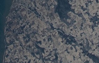
The
Ahnapee River on February 7, 2022, taken from the International Space Station. The source of the river (lower right) is at the southeast of
363:. The millpond at Forestville (center) appears as a long white spot. The river flows southwest towards its mouth at Algoma (upper left).
319:
The
Ahnapee rises in southern Door County and flows generally southeastwardly into northeastern Kewaunee County, past the village of
339:. It joins Lake Michigan at the city of Algoma. The length of the river from Forestville to Algoma has ten public access points.
201:
391:
The upper part of the
Forestville Millpond, with the upper portion of the Ahnapee River flowing into it; taken June 27, 2020
556:
541:
403:
The lower part of the
Forestville Millpond and the start of the lower portion of the Ahnapee River; taken June 27, 2020
360:
130:
478:
292:
441:
259:
320:
288:
510:
28:
376:
336:
300:
183:
304:
50:
276:
87:
550:
296:
284:
171:
67:
460:
U.S. Geological Survey. National
Hydrography Dataset high-resolution flowline data.
375:
The source of the upper portion of the
Ahnapee River upstream from where it crosses
513:
by the Bay-Lake
Regional Planning Commission, June 2019, page 4 (electronic page 8)
166:
531:
332:
328:
216:
203:
145:
132:
280:
187:
116:
77:
461:
415:
The
Ahnapee on June 27, 2020 as it crosses the Door–Kewaunee county line.
527:
Wisconsin DNR page about
Ahnapee River Wetlands, including photographs
532:
A Canoe Trip on the
Ahnapee River with Herb Klein and Cal Holvenstadt
272:
499:
Interactive trail map showing the Ahnapee river ending in Algoma
324:
501:(the Ice Age Trail joins the Ahnapee trail for several parts)
477:. Wisconsin Department of Natural Resources. Archived from
498:
427:
The river in Algoma, from a postcard postmarked in 1960
253:
245:
240:
232:
193:
177:
165:
122:
110:
102:
93:
83:
73:
63:
58:
38:
21:
327:. Downstream of Forestville the river becomes a
303:. Its name has been ascribed as coming from the
542:Ahnapee River Water Trail Interactive Tour Map
33:The Ahnapee River below the dam at Forestville
567:Bodies of water of Kewaunee County, Wisconsin
8:
42:
562:Bodies of water of Door County, Wisconsin
331:of Lake Michigan and is paralleled by a
453:
349:
18:
7:
271:is a 14.7-mile-long (23.7 km)
14:
16:River in Wisconsin, United States
420:
408:
396:
384:
368:
352:
27:
534:, produced by Laddie Chapman,
511:Ahnapee River Water Trail Plan
195: • coordinates
124: • coordinates
1:
94:Physical characteristics
464:, accessed December 19, 2011
179: • location
112: • location
583:
161:
98:
26:
442:List of Wisconsin rivers
538:, Saturday May 10, 2007
255: • left
236:15 mi (24 km)
289:Door County, Wisconsin
43:
536:Sevastopol Channel 19
379:, taken June 27, 2020
217:44.60833°N 87.43306°W
146:44.76889°N 87.53917°W
377:Wisconsin Highway 57
291:, and flows through
557:Rivers of Wisconsin
337:Ahnapee State Trail
241:Basin features
222:44.60833; -87.43306
213: /
151:44.76889; -87.53917
142: /
329:freshwater estuary
311:meaning "when?".
265:
264:
574:
514:
508:
502:
496:
490:
489:
487:
486:
471:
465:
462:The National Map
458:
424:
412:
400:
388:
372:
356:
256:
228:
227:
225:
224:
223:
218:
214:
211:
210:
209:
206:
157:
156:
154:
153:
152:
147:
143:
140:
139:
138:
135:
125:
113:
54:
46:
31:
19:
582:
581:
577:
576:
575:
573:
572:
571:
547:
546:
523:
518:
517:
509:
505:
497:
493:
484:
482:
475:"Ahnapee River"
473:
472:
468:
459:
455:
450:
438:
433:
432:
431:
428:
425:
416:
413:
404:
401:
392:
389:
380:
373:
364:
357:
345:
317:
299:at the city of
293:Kewaunee County
254:
221:
219:
215:
212:
207:
204:
202:
200:
199:
196:
180:
150:
148:
144:
141:
136:
133:
131:
129:
128:
123:
111:
48:
34:
17:
12:
11:
5:
580:
578:
570:
569:
564:
559:
549:
548:
545:
544:
539:
529:
522:
521:External links
519:
516:
515:
503:
491:
466:
452:
451:
449:
446:
445:
444:
437:
434:
430:
429:
426:
419:
417:
414:
407:
405:
402:
395:
393:
390:
383:
381:
374:
367:
365:
358:
351:
348:
347:
346:
344:
341:
323:, where it is
316:
313:
287:. It rises in
277:Door Peninsula
263:
262:
257:
251:
250:
247:
243:
242:
238:
237:
234:
230:
229:
197:
194:
191:
190:
181:
178:
175:
174:
169:
163:
162:
159:
158:
126:
120:
119:
114:
108:
107:
104:
100:
99:
96:
95:
91:
90:
88:Door Peninsula
85:
81:
80:
75:
71:
70:
65:
61:
60:
56:
55:
40:
36:
35:
32:
24:
23:
15:
13:
10:
9:
6:
4:
3:
2:
579:
568:
565:
563:
560:
558:
555:
554:
552:
543:
540:
537:
533:
530:
528:
525:
524:
520:
512:
507:
504:
500:
495:
492:
481:on 2009-09-27
480:
476:
470:
467:
463:
457:
454:
447:
443:
440:
439:
435:
423:
418:
411:
406:
399:
394:
387:
382:
378:
371:
366:
362:
361:Gardner Swamp
355:
350:
342:
340:
338:
334:
330:
326:
322:
314:
312:
310:
306:
302:
298:
297:Lake Michigan
294:
290:
286:
285:United States
282:
278:
274:
270:
269:Ahnapee River
261:
258:
252:
248:
244:
239:
235:
231:
226:
198:
192:
189:
185:
182:
176:
173:
172:Lake Michigan
170:
168:
164:
160:
155:
127:
121:
118:
115:
109:
106:Gardner Swamp
105:
101:
97:
92:
89:
86:
82:
79:
76:
72:
69:
68:United States
66:
62:
57:
52:
45:
41:
37:
30:
25:
22:Ahnapee River
20:
535:
506:
494:
483:. Retrieved
479:the original
469:
456:
318:
308:
268:
266:
260:Silver Creek
335:called the
321:Forestville
279:in eastern
246:Tributaries
220: /
149: /
39:Native name
551:Categories
485:2009-05-03
448:References
333:rail trail
208:87°25′59″W
205:44°36′30″N
137:87°32′21″W
134:44°46′08″N
281:Wisconsin
188:Wisconsin
117:Wisconsin
78:Wisconsin
436:See also
59:Location
343:Gallery
309:aanapii
283:in the
275:on the
64:Country
44:Aanapii
325:dammed
315:Course
305:Ojibwe
301:Algoma
249:
233:Length
184:Algoma
103:Source
84:Region
51:Ojibwe
47:
307:word
295:into
273:river
167:Mouth
74:State
267:The
553::
186:,
488:.
53:)
49:(
Text is available under the Creative Commons Attribution-ShareAlike License. Additional terms may apply.