336:
348:
360:
52:
40:
303:
upstream due to the influx of tributaries, which intensified the floods there. The
Aiviekste floodplain in the middle of the river is a nature reserve as a habitat for birds and a home for rare plants. The fall of the river to the Aiviekste hydroelectric power station of Aiviekste is 1 m by 14 km, and only after that in the last 14 km it increases tenfold.
302:
in the basin, large swamps. Aiviekste is rich in fish. Aiviekste is regulated by locks and canals, as its flow capacity is several times too low when the flood season begins in Lake Lubāns. Until the end of 20th century, during the spring floods, the waters of
Aiviekste flowed back into Lubāns
275:, Bolupe and Iča. Furthermore, it was straightened and deepened for 83 km. At the lower end, Aiviekste flows through a slightly undulating area. There are several islands, sandbars and about 15 stone sills here in the river. The small
263:, although the administrative border was slightly different. The river is 114 kilometers long, with annual drainage 1.81 km. The Aiviekste is between 10,000 and 12,000 years old, formed at the end of the last
270:
The
Aiviekste flows from the northern end of Lake Lubāns, where it does a wide semicircle and then turns southwest. At this stage is the smallest drop, in addition, here Aiviekste receives the largest tributaries
279:(1.4 MW) was built on one of these island groups. After the construction of the Pļaviņu hydroelectric power plant, the lower end of Aiviekste is flooded with a reservoir. It flows through the towns of
141:
406:
335:
276:
347:
466:
251:(the largest river in Latvia). The Aiviekste is the largest tributary of the Daugava in Latvia. The Aiviekste, along with the
267:. Nearly a quarter of the river's flow is unregulated, but most of the river has been excavated, including with explosions.
359:
471:
298:). 25% of the area of the Aiviekste basin is covered by forests, 15% - by marshes. There are many
395:
291:
284:
244:
127:
99:
460:
448:
51:
437:
110:
17:
299:
227:
156:
143:
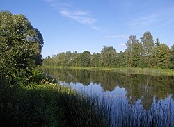
407:
Latvenergo. Rekonstruētā Aiviekstes HES palielinās zaļās enerģijas izstrādi
280:
39:
316:
272:
264:
260:
256:
252:
248:
223:
115:
255:, forms the unofficial border between two historical Latvian regions
240:
70:
426:
320:
290:
The river collects water mainly from the East
Latvian lowland (
206:
57.4 cubic metres per second (2,030 cu ft/s)
219:
214:
200:
192:
180:
172:
133:
121:
109:
93:
85:
76:
66:
61:
32:
247:(the largest lake in Latvia) and drains into the
287:(estuary). Near Krievciems - a dolomite quarry.
438:Nature Conservation Board. Aiviekstes paliene
8:
396:Aiviekste floodplain. Nature protection plan
417:Small Encyclopedia of Latvian SSR, p. 1-39.
50:
376:
331:
29:
386:Latvian Soviet Encyclopedia, p. 1-99.
382:
380:
184:9,160 km (3,540 sq mi)
7:
277:Aiviekste hydroelectric power plant
312:Left side: Zvidze, Isliena, Abaine
25:
358:
346:
334:
38:
341:Aiviekste near bridge of Veseta
323:, Kuja, Svētupe, Arona, Veseta
135: • coordinates
1:
449:Upesoga: boating in Aiviekste
77:Physical characteristics
427:Aiviekste boating. Aiviekste
315:Right side: Iča, Piestiņa,
176:114 kilometres (71 mi)
123: • location
95: • location
488:
467:Tributaries of the Daugava
202: • average
210:
188:
105:
81:
49:
44:Aiviekste near the source
37:
296:Austrumlatvijas zemiene
295:
353:Aiviekste power plant
365:Aiviekste in Ļaudona
215:Basin features
157:56.6144°N 25.7583°E
153: /
56:The Aiviekste river
233:
232:
16:(Redirected from
479:
472:Rivers of Latvia
451:
446:
440:
435:
429:
424:
418:
415:
409:
404:
398:
393:
387:
384:
362:
350:
338:
203:
168:
167:
165:
164:
163:
162:56.6144; 25.7583
158:
154:
151:
150:
149:
146:
96:
54:
42:
30:
21:
487:
486:
482:
481:
480:
478:
477:
476:
457:
456:
455:
454:
447:
443:
436:
432:
425:
421:
416:
412:
405:
401:
394:
390:
385:
378:
373:
366:
363:
354:
351:
342:
339:
330:
309:
243:. It begins at
201:
161:
159:
155:
152:
147:
144:
142:
140:
139:
136:
124:
94:
57:
45:
28:
27:River in Latvia
23:
22:
18:Aiviekste River
15:
12:
11:
5:
485:
483:
475:
474:
469:
459:
458:
453:
452:
441:
430:
419:
410:
399:
388:
375:
374:
372:
369:
368:
367:
364:
357:
355:
352:
345:
343:
340:
333:
329:
326:
325:
324:
313:
308:
305:
239:is a river in
231:
230:
221:
217:
216:
212:
211:
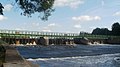
208:
207:
204:
198:
197:
194:
190:
189:
186:
185:
182:
178:
177:
174:
170:
169:
137:
134:
131:
130:
125:
122:
119:
118:
113:
107:
106:
103:
102:
97:
91:
90:
87:
83:
82:
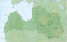
79:
78:
74:
73:
68:
64:
63:
59:
58:
55:
47:
46:
43:
35:
34:
26:
24:
14:
13:
10:
9:
6:
4:
3:
2:
484:
473:
470:
468:
465:
464:
462:
450:
445:
442:
439:
434:
431:
428:
423:
420:
414:
411:
408:
403:
400:
397:
392:
389:
383:
381:
377:
370:
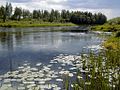
361:
356:
349:
344:
337:
332:
327:
322:
318:
314:
311:
310:
306:
304:
301:
297:
293:
288:
286:
282:
278:
274:
268:
266:
262:
258:
254:
250:
246:
242:
238:
229:
225:
222:
218:
213:
209:
205:
199:
195:
191:
187:
183:
179:
175:
171:
166:
138:
132:
129:
126:
120:
117:
114:
112:
108:
104:
101:
98:
92:
88:
84:
80:
75:
72:
69:
65:
60:
53:
48:
41:
36:
31:
19:
444:
433:
422:
413:
402:
391:
289:
269:
236:
234:
307:Tributaries
300:wet meadows
245:Lake Lubāns
220:Progression
160: /
100:Lake Lubāns
461:Categories
371:References
228:Baltic Sea
181:Basin size
148:25°45′30″E
145:56°36′52″N
237:Aiviekste
193:Discharge
33:Aiviekste
285:Pļaviņas
128:Pļaviņas
62:Location
328:Gallery
317:Pededze
292:Latvian
273:Pededze
265:ice age
261:Latgale
257:Vidzeme
253:Pededze
249:Daugava
224:Daugava
116:Daugava
67:Country
281:Lubāna
241:Latvia
196:
173:Length
89:
86:Source
71:Latvia
321:Liede
111:Mouth
283:and
259:and
235:The
463::
379:^
319:,
294::
226:→
20:)
Text is available under the Creative Commons Attribution-ShareAlike License. Additional terms may apply.