41:
292:
350:, resulting in a yield of 140 kg in 1982, and a pursuance to build similar greenhouses elsewhere in the country. There is a large government-owned plant nursery in the village which covers 2,500 sq meters. Plants from the nursery are used in research and also distributed to government ministries. It was established in 2003. Numerous privately-owned farms have also been established in the area, most of which are mixed-use and grow fodder crops in addition to raising livestock.
57:
1066:
700:
399:
64:
581:
480:
304:
and elsewhere for work. As a result of poor living conditions, many of the original residents have migrated to Doha. In 2016, it was estimated that around 500 inhabitants occupied the village, with an overall 47 homes being recorded, all of which are resided in by more than one family.
333:
The village is primarily rural community centered on agriculture. No health care or educational facilities were recorded in the 2010 census. The village also lacks parks, schools, supermarkets and gas stations. For public services and food items, most residents travel to
299:
Settlers first came to the region in the 1960s, despite being cut off from many essential services. In the 1980s, the village was connected to Qatar's power grid system. Mixed-use farms comprise the livelihood of some residents, while others commute to the capital
325:(depressions), which distinguishes it from the flatter areas to the north and east. To the west of the Al Utouriya-Al-Shahaniya Road, there is a notable change in the landscape, opening up into a wide, spacious plain with distinct features.
346:
An experimental farm was established here by the government in the early 1980s in an initiative to boost food self-sufficiency. The farm's greenhouses successfully extended the growing season of
689:
453:
607:
236:
municipality before the municipality was incorporated into Al Rayyan. In 2014, the village was incorporated into the newly created Al-Shahaniya
Municipality.
421:
1089:
1052:
682:
649:
85:
40:
367:
675:
457:
505:
56:
894:
556:
531:
252:, which translates to 'perfume' or 'aroma'. It was given this name due to the scent emanating from a nearby rawdat (
1047:
428:
603:
749:
744:
909:
884:
214:
127:
199:
1069:
869:
949:
934:
729:
291:
754:
322:
253:
1024:
879:
819:
794:
739:
222:
1019:
874:
759:
314:
904:
899:
839:
889:
944:
260:
245:
190:
1001:
961:
921:
851:
811:
776:
711:
144:
139:
1083:
1014:
859:
799:
509:
969:
784:
703:
335:
233:
226:
218:
132:
317:
region. As part of this section, the area has varied topography, including hills,
667:
633:
313:
Al
Utouriya is in north-central Qatar. It forms part of the northern zone of the
984:
974:
939:
1029:
864:
829:
824:
789:
734:
427:. Ministry of Development Planning and Statistics. April 2015. Archived from
100:
87:
979:
834:
699:
989:
347:
508:. The Centre for Geographic Information Systems of Qatar. Archived from
929:
764:
724:
318:
1009:
611:
290:
210:
120:
301:
671:
221:. The village lies about 20 kilometres (12 mi) north of
400:"العطورية.. بلدة وادعة وجميلة هجرها أهلها بسبب قلة الخدمات"
584:(in Arabic). Qatar Historical Encyclopedia. 28 April 2024
204:
1040:
1000:
960:
920:
850:
810:
775:
710:
176:
171:
163:
158:
150:
138:
126:
116:
21:
370:. Ministry of Development Planning and Statistics
481:"بلدية الشحانية تضم %35 من مساحة الريان الحالية"
608:Ministry of Development Planning and Statistics
683:
635:Arabia: The Islamic World Review, Issues 7-16
8:
456:. Qatar Statistics Authority. Archived from
393:
391:
389:
387:
385:
690:
676:
668:
256:) which hosts a number of aromatic herbs.
229:. It is connected to both places by road.
18:
638:. Islamic Press Agency. 1982. p. 34.
1053:Sheikh Faisal Bin Qassim Al Thani Museum
398:Mohammed Sayed Ahmed (21 January 2016).
359:
244:Al Utouriya's name is derived from the
170:
157:
115:
80:
49:
37:
650:"تدشين أسبوع الشجرة بروضة بخيلة اليوم"
500:
498:
175:
162:
149:
137:
125:
7:
194:
63:
652:(in Arabic). Al Raya. 2 March 2008
167:25.7 km (9.9 sq mi)
14:
479:Hisham Yassin (16 January 2014).
1090:Populated places in Al-Shahaniya
1065:
1064:
698:
62:
55:
39:
225:and the same distance south of
16:Village in Al-Shahaniya, Qatar
1:
1048:Al-Shahaniya Camel Racetrack
604:"Geo Statistics Application"
263:of the name exist, such as
205:
177: • Estimate
1106:
232:It used to be part of the
1061:
704:Al-Shahaniya Municipality
582:"طبوغرافية شبه جزيرة قطر"
81:
50:
38:
31:
454:"2004 population census"
422:"2015 Population census"
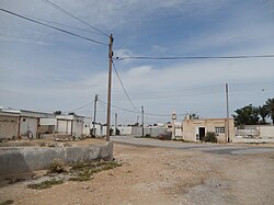
295:Main road to Al Utouriya
25:
885:Umm Al Zubar Al Qibliya
750:Umm Al Qahab Al Qadeema
745:Umm Al Qahab Al Jadeeda
910:Wadi Lejmal Al Shamali
296:
1070:Category:Al-Shahaniya
870:Al Sahla Al Shamaliya
532:"Al Athārīyah: Qatar"
294:
101:25.51500°N 51.20306°E
45:Village scene in 2015
483:(in Arabic). Al Arab
460:on 24 September 2015
402:(in Arabic). Al Arab
259:Various alternative
740:Umm Al Daah Khawzan
512:on 20 November 2022
368:"District Area Map"
97: /
875:Madinat Al Mawater
557:"Latariyah: Qatar"
297:
209:) is a village in
164: • Total
106:25.51500; 51.20306
1077:
1076:
950:Qaryat Al Muhanna
890:Umm Al Zubar East
820:Al Shahaniya City
223:Al-Shahaniya City
213:, located in the
203:
184:
183:
1097:
1068:
1067:
730:Qaryat Al Refaiq
702:
692:
685:
678:
669:
662:
661:
659:
657:
646:
640:
639:
630:
624:
623:
621:
619:
610:. Archived from
600:
594:
593:
591:
589:
578:
572:
571:
569:
567:
553:
547:
546:
544:
542:
528:
522:
521:
519:
517:
502:
493:
492:
490:
488:
476:
470:
469:
467:
465:
450:
444:
443:
441:
439:
433:
426:
418:
412:
411:
409:
407:
395:
380:
379:
377:
375:
364:
261:transliterations
208:
198:
196:
112:
111:
109:
108:
107:
102:
98:
95:
94:
93:
90:
66:
65:
59:
43:
19:
1105:
1104:
1100:
1099:
1098:
1096:
1095:
1094:
1080:
1079:
1078:
1073:
1057:
1036:
996:
956:
916:
846:
806:
771:
755:Umm Leghab West
706:
696:
666:
665:
655:
653:
648:
647:
643:
632:
631:
627:
617:
615:
602:
601:
597:
587:
585:
580:
579:
575:
565:
563:
555:
554:
550:
540:
538:
530:
529:
525:
515:
513:
504:
503:
496:
486:
484:
478:
477:
473:
463:
461:
452:
451:
447:
437:
435:
434:on 17 July 2016
431:
424:
420:
419:
415:
405:
403:
397:
396:
383:
373:
371:
366:
365:
361:
356:
344:
331:
311:
289:
242:
105:
103:
99:
96:
91:
88:
86:
84:
83:
77:
76:
75:
74:
73:
72:
71:
67:
46:
34:
27:
24:
17:
12:
11:
5:
1103:
1101:
1093:
1092:
1082:
1081:
1075:
1074:
1062:
1059:
1058:
1056:
1055:
1050:
1044:
1042:
1038:
1037:
1035:
1034:
1033:
1032:
1027:
1025:Al Ruwais West
1022:
1017:
1006:
1004:
998:
997:
995:
994:
993:
992:
987:
982:
977:
966:
964:
958:
957:
955:
954:
953:
952:
947:
942:
937:
926:
924:
918:
917:
915:
914:
913:
912:
907:
902:
897:
895:Umm Ghuwailina
892:
887:
882:
880:Umm Al Maqarin
877:
872:
867:
856:
854:
848:
847:
845:
844:
843:
842:
837:
832:
827:
816:
814:
808:
807:
805:
804:
803:
802:
797:
792:
781:
779:
773:
772:
770:
769:
768:
767:
762:
757:
752:
747:
742:
737:
732:
727:
716:
714:
708:
707:
697:
695:
694:
687:
680:
672:
664:
663:
641:
625:
595:
573:
561:geographic.org
548:
536:geographic.org
523:
494:
471:
445:
413:
381:
358:
357:
355:
352:
343:
340:
330:
329:Infrastructure
327:
310:
307:
288:
285:
241:
238:
182:
181:
178:
174:
173:
169:
168:
165:
161:
160:
156:
155:
152:
148:
147:
142:
136:
135:
130:
124:
123:
118:
114:
113:
79:
78:
69:
68:
61:
60:
54:
53:
52:
51:
48:
47:
44:
36:
35:
32:
29:
28:
22:
15:
13:
10:
9:
6:
4:
3:
2:
1102:
1091:
1088:
1087:
1085:
1072:
1071:
1060:
1054:
1051:
1049:
1046:
1045:
1043:
1039:
1031:
1028:
1026:
1023:
1021:
1018:
1016:
1013:
1012:
1011:
1008:
1007:
1005:
1003:
999:
991:
988:
986:
983:
981:
978:
976:
973:
972:
971:
968:
967:
965:
963:
959:
951:
948:
946:
943:
941:
938:
936:
933:
932:
931:
928:
927:
925:
923:
919:
911:
908:
906:
903:
901:
898:
896:
893:
891:
888:
886:
883:
881:
878:
876:
873:
871:
868:
866:
863:
862:
861:
860:Rawdat Rashed
858:
857:
855:
853:
849:
841:
838:
836:
833:
831:
828:
826:
823:
822:
821:
818:
817:
815:
813:
809:
801:
800:Al Suwaihliya
798:
796:
793:
791:
788:
787:
786:
783:
782:
780:
778:
774:
766:
763:
761:
758:
756:
753:
751:
748:
746:
743:
741:
738:
736:
733:
731:
728:
726:
723:
722:
721:
718:
717:
715:
713:
709:
705:
701:
693:
688:
686:
681:
679:
674:
673:
670:
651:
645:
642:
637:
636:
629:
626:
614:on 2012-09-11
613:
609:
605:
599:
596:
583:
577:
574:
562:
558:
552:
549:
537:
533:
527:
524:
511:
507:
501:
499:
495:
482:
475:
472:
459:
455:
449:
446:
430:
423:
417:
414:
401:
394:
392:
390:
388:
386:
382:
369:
363:
360:
353:
351:
349:
341:
339:
337:
328:
326:
324:
320:
316:
308:
306:
303:
293:
286:
284:
282:
278:
274:
270:
266:
262:
257:
255:
251:
247:
239:
237:
235:
230:
228:
224:
220:
216:
212:
207:
201:
192:
188:
179:
166:
153:
146:
143:
141:
134:
131:
129:
122:
119:
110:
82:Coordinates:
58:
42:
30:
20:
1063:
970:Al Nasraniya
785:Al Jemailiya
719:
654:. Retrieved
644:
634:
628:
616:. Retrieved
612:the original
598:
586:. Retrieved
576:
564:. Retrieved
560:
551:
539:. Retrieved
535:
526:
514:. Retrieved
510:the original
485:. Retrieved
474:
462:. Retrieved
458:the original
448:
436:. Retrieved
429:the original
416:
404:. Retrieved
372:. Retrieved
362:
345:
336:Al Jemailiya
332:
315:central belt
312:
298:
280:
276:
273:Al Athārīyah
272:
268:
265:Al `Aţūrīyah
264:
258:
249:
243:
234:Al Jemailiya
231:
227:Al Jemailiya
219:Al-Shahaniya
215:municipality
206:Al Athārīyah
186:
185:
151:District no.
133:Al-Shahaniya
128:Municipality
1020:Al Khattiya
985:Al Salamiya
975:Al Kharsaah
940:Al Shabhana
760:Wadi Laswaq
720:Al Utouriya
566:28 February
541:28 February
506:"Geoportal"
374:15 February
342:Agriculture
187:Al Utouriya
104: /
70:Al Utouriya
23:Al Utouriya
1030:Al Zeghain
905:Umm Wishah
900:Umm Lebrak
865:Abu Nakhla
840:Umm Leghab
830:Al Samriya
825:Al Khurayb
790:Abu Sidrah
735:Ras Abrouq
406:7 December
354:References
281:Leatooriya
269:Al Atoriya
254:depression
172:Population
92:51°12′11″E
89:25°30′54″N
1041:Landmarks
980:Al Owaina
835:Lehsiniya
795:Al Qa'iya
348:cucumbers
309:Geography
277:Latariyah
240:Etymology
200:romanized
1084:Category
990:Umm Taqa
935:Al Hamla
656:8 August
618:7 August
487:7 August
438:8 August
319:plateaus
195:العطورية
26:العطورية
1002:Zone 86
962:Zone 85
945:Jelaiha
930:Umm Bab
922:Zone 84
852:Zone 82
812:Zone 80
777:Zone 73
765:Zekreet
725:Lehsain
712:Zone 72
588:20 July
287:History
202::
145:Zone 72
117:Country
33:Village
1010:Dukhan
516:25 May
464:1 July
323:rawdas
321:, and
279:, and
246:Arabic
191:Arabic
1015:Afjan
432:(PDF)
425:(PDF)
248:word
211:Qatar
121:Qatar
658:2017
620:2015
590:2024
568:2019
543:2019
518:2018
489:2017
466:2015
440:2017
408:2019
376:2019
302:Doha
250:atar
159:Area
140:Zone
217:of
180:500
154:158
1086::
606:.
559:.
534:.
497:^
384:^
338:.
283:.
275:,
271:,
267:,
197:,
193::
691:e
684:t
677:v
660:.
622:.
592:.
570:.
545:.
520:.
491:.
468:.
442:.
410:.
378:.
189:(
Text is available under the Creative Commons Attribution-ShareAlike License. Additional terms may apply.