508:. A pond in a moraine enclosed basin at the foot of the cliffs to the south end of Alatna Valley, in the Convoy Range of Victoria Land. This frozen pond was the site of a 1960-61 USARP field party (Parker Calkin, Roger Hart, and Ellory Schempp) which had to be evacuated in a hurry. Equipment and provisions stockpiled on the pond ice were eventually redistributed by the wind and lodged among the surrounding morainic boulders. A 1989-90 NZARP party (Trevor Chinn) camped nearby made frequent visits to the site to clean up the area, but also to acquire various 30-year old exotic foods to supplement their standard camp fare.
418:. However, it was determined by a 1989-90 NZARP field party (Trevor Chinn) that although it abuts against the main Benson Glacier at Jetsam Moraine, this glacier makes no contribution of ice to the Benson as its dominant ice flow is northward across its length. With the identification of Midship Glacier as a distinct feature, the application of Benson Glacier has been restricted to the ice flowing eastward from Flight Deck Neve" to the terminus in Granite Harbor. Approved by US-ACAN in 1993 as recommended by the NZGB.
33:
245:
376:. A substantial mountain glacier, 3 nautical miles (5.6 km; 3.5 mi) wide, which flows southward into Alatna Valley, draining both the Staten Island Heights and Mount Razorback areas. So named by a 1989-90 NZARP field party because strong and persistent winds in this vicinity have cut major flutings through the ice-cliffed terminus of the glacier.
40:
865:
781:
584:. The smaller and western of two closely spaced frozen ponds in the floor of Alatna Valley, filled by overflow from the larger adjacent Rum Pond. Named by a 1989-90 NZARP field party (Trevor Chinn) in association with Rum Pond; in nautical circles a tot is a traditional small issue of rum.
291:
in the Convoy Range. This high elevation glacier is adjacent to the névé of
Cambridge Glacier and snow laden katabatic winds make their first descent into Alatna Valley over the glacier. Even on days of relatively light winds, snow clouds derived from the high
338:. An alpine glacier, 1.5 nautical miles (2.8 km; 1.7 mi) long, which flows into Alatna Valley from the south end of Staten Island Heights. Descriptively named from the pointed terminus of this glacier by a NZARP field party to the area, 1989-90.
546:. The larger and eastern of two closely spaced frozen ponds in the floor of Alatna Valley. The name is one of a group in Convoy Range reflecting a nautical theme. Named after this traditional naval beverage by a 1989-90 NZARP field party.
869:
785:
464:
and flows north to the head of Alatna Valley. Named by New
Zealand Geographic Board (NZGB) (c. 1980) in association with the names of ships grouped in Convoy Range; lugger being a small vessel with four-sided sails.
833:
414:. A broad flat glacier filling the bulk of Alatna Valley and having its origin on the slopes of Mount Morrison to the south. From 1957 this ice body was considered part of
826:
297:
789:
32:
817:
287:. An abrupt glacier, 3 nautical miles (5.6 km; 3.5 mi) long, descending into the end of Alatna Valley from the south side of
844:
162:
Parker Calkin, U.S. geologist, made stratigraphic studies in the valley during the 1960-61 season. Named by US-ACAN in 1963 for the
873:
822:
888:
428:
169:
which participated in
Operation Deep Freeze 1958-59 and 1959–60, and in keeping with other ship names in the Convoy Range.
78:
71:
556:
518:
480:
386:
348:
310:
259:
150:
and trending east-northeast for about 10 nautical miles (19 km; 12 mi) along the southeast side of the
118:
456:. A broad glacier, 3.6 nautical miles (6.7 km; 4.1 mi) long, which occupies the upland northward of
206:
812:
178:
233:
228:
244:
223:
796:
415:
190:
182:
882:
763:
457:
186:
151:
146:) is an ice-free valley lying 4 nautical miles (7.4 km; 4.6 mi) north of
163:
461:
288:
147:
571:
558:
533:
520:
495:
482:
443:
430:
401:
388:
363:
350:
325:
312:
296:
may be seen swirling and scudding down this glacier. So named by the 1989-90
293:
274:
261:
218:
133:
120:
93:
80:
243:
637:
621:
619:
185:
flows east from below the east end of the valley. The
771:(2 ed.), United States Board on Geographic Names
70:
62:
57:
21:
709:
649:
8:
600:The name is sometimes incorrectly spelled
18:
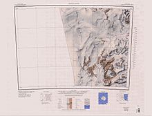
177:The Alatna Valley is to the southeast of
827:United States Department of the Interior
298:New Zealand Antarctic Research Programme
801:, USGS: United States Geological Survey
790:United States Board on Geographic Names
745:
733:
721:
697:
685:
673:
661:
625:
615:
593:
834:"Map of the McMurdo Dry Valleys Area"
39:
7:
189:flow south from the valley into the
818:Geographic Names Information System
248:Convoy Range is south center of map
872:from websites or documents of the
788:from websites or documents of the
14:
765:Geographic Names of the Antarctic
300:(NZARP) field party to the area.
868: This article incorporates
863:
784: This article incorporates
779:
38:
31:
874:United States Geological Survey
823:United States Geological Survey
762:Alberts, Fred G., ed. (1995),
638:Map of the McMurdo Dry Valleys
1:
234:GPX (secondary coordinates)
905:
444:76.9666667°S 160.8333333°E
229:GPX (primary coordinates)
204:Map all coordinates using
26:
841:www.antarcticanz.govt.nz
449:-76.9666667; 160.8333333
212:Download coordinates as:
870:public domain material
786:public domain material
249:
158:Exploration and naming
889:Valleys of Antarctica
247:
224:GPX (all coordinates)
179:Staten Island Heights
850:on December 17, 2008
16:Valley in Antarctica
710:Lugger Glacier USGS
700:, pp. 489–490.
568: /
530: /
492: /
440: /
398: /
360: /
322: /
271: /
130: /
90: /
572:76.900°S 161.117°E
534:76.900°S 161.117°E
496:76.917°S 161.083°E
402:76.867°S 161.500°E
364:76.867°S 161.167°E
326:76.867°S 160.933°E
275:76.900°S 160.750°E
250:
134:76.883°S 161.167°E
650:Convoy Range USGS
110:
109:
896:
867:
866:
858:
857:
855:
849:
843:, archived from
838:
829:
813:"Lugger Glacier"
808:
807:
806:
783:
782:
778:
777:
776:
770:
749:
743:
737:
731:
725:
719:
713:
707:
701:
695:
689:
683:
677:
671:
665:
659:
653:
647:
641:
635:
629:
623:
604:
598:
583:
582:
580:
579:
578:
577:-76.900; 161.117
573:
569:
566:
565:
564:
561:
545:
544:
542:
541:
540:
539:-76.900; 161.117
535:
531:
528:
527:
526:
523:
507:
506:
504:
503:
502:
501:-76.917; 161.083
497:
493:
490:
489:
488:
485:
455:
454:
452:
451:
450:
445:
441:
438:
437:
436:
433:
413:
412:
410:
409:
408:
407:-76.867; 161.500
403:
399:
396:
395:
394:
391:
375:
374:
372:
371:
370:
369:-76.867; 161.167
365:
361:
358:
357:
356:
353:
342:Wildwind Glacier
337:
336:
334:
333:
332:
331:-76.867; 160.933
327:
323:
320:
319:
318:
315:
304:Sharpend Glacier
286:
285:
283:
282:
281:
280:-76.900; 160.750
276:
272:
269:
268:
267:
264:
253:Scudding Glacier
145:
144:
142:
141:
140:
139:-76.883; 161.167
135:
131:
128:
127:
126:
123:
105:
104:
102:
101:
100:
95:
94:76.88°S 161.17°E
91:
88:
87:
86:
83:
42:
41:
35:
19:
904:
903:
899:
898:
897:
895:
894:
893:
879:
878:
864:
861:
853:
851:
847:
836:
832:
811:
804:
802:
795:
780:
774:
772:
768:
761:
757:
752:
744:
740:
732:
728:
720:
716:
708:
704:
696:
692:
684:
680:
672:
668:
660:
656:
648:
644:
636:
632:
624:
617:
613:
608:
607:
599:
595:
590:
576:
574:
570:
567:
562:
559:
557:
555:
554:
552:
538:
536:
532:
529:
524:
521:
519:
517:
516:
514:
500:
498:
494:
491:
486:
483:
481:
479:
478:
476:
471:
448:
446:
442:
439:
434:
431:
429:
427:
426:
424:
406:
404:
400:
397:
392:
389:
387:
385:
384:
382:
380:Midship Glacier
368:
366:
362:
359:
354:
351:
349:
347:
346:
344:
330:
328:
324:
321:
316:
313:
311:
309:
308:
306:
279:
277:
273:
270:
265:
262:
260:
258:
257:
255:
242:
241:
240:
239:
238:
199:
175:
160:
138:
136:
132:
129:
124:
121:
119:
117:
116:
98:
96:
92:
89:
84:
81:
79:
77:
76:
53:
52:
51:
50:
49:
48:
47:
43:
17:
12:
11:
5:
902:
900:
892:
891:
881:
880:
860:
859:
830:
809:
793:
758:
756:
753:
751:
750:
748:, p. 754.
738:
726:
724:, p. 119.
714:
702:
690:
688:, p. 813.
678:
676:, p. 667.
666:
664:, p. 658.
654:
642:
630:
614:
612:
609:
606:
605:
602:Atlanta Valley
592:
591:
589:
586:
551:
548:
513:
510:
475:
472:
470:
469:Other features
467:
423:
422:Lugger Glacier
420:
416:Benson Glacier
381:
378:
343:
340:
305:
302:
254:
251:
237:
236:
231:
226:
221:
215:
209:
202:
201:
200:
198:
195:
191:Mackay Glacier
183:Benson Glacier
174:
171:
159:
156:
154:, Antarctica.
108:
107:
99:-76.88; 161.17
74:
68:
67:
64:
60:
59:
55:
54:
45:
44:
37:
36:
30:
29:
28:
27:
24:
23:
15:
13:
10:
9:
6:
4:
3:
2:
901:
890:
887:
886:
884:
877:
875:
871:
846:
842:
835:
831:
828:
824:
820:
819:
814:
810:
800:
799:
794:
791:
787:
767:
766:
760:
759:
754:
747:
742:
739:
735:
730:
727:
723:
718:
715:
711:
706:
703:
699:
694:
691:
687:
682:
679:
675:
670:
667:
663:
658:
655:
651:
646:
643:
639:
634:
631:
627:
622:
620:
616:
610:
603:
597:
594:
587:
585:
581:
549:
547:
543:
511:
509:
505:
473:
468:
466:
463:
459:
453:
421:
419:
417:
411:
379:
377:
373:
341:
339:
335:
303:
301:
299:
295:
290:
284:
252:
246:
235:
232:
230:
227:
225:
222:
220:
217:
216:
214:
213:
208:
207:OpenStreetMap
205:
196:
194:
192:
188:
184:
180:
172:
170:
168:
167:
157:
155:
153:
149:
143:
114:
113:Alatna Valley
103:
75:
73:
69:
65:
61:
56:
46:Alatna Valley
34:
25:
22:Alatna Valley
20:
862:
852:, retrieved
845:the original
840:
816:
803:, retrieved
798:Convoy Range
797:
773:, retrieved
764:
746:Alberts 1995
741:
734:Alberts 1995
729:
722:Alberts 1995
717:
705:
698:Alberts 1995
693:
686:Alberts 1995
681:
674:Alberts 1995
669:
662:Alberts 1995
657:
645:
633:
628:, p. 9.
626:Alberts 1995
601:
596:
553:
515:
477:
458:Mount Bergen
425:
383:
345:
307:
256:
211:
210:
203:
187:Gran Glacier
176:
165:
161:
152:Convoy Range
112:
111:
854:October 26,
575: /
537: /
499: /
447: /
435:160°50′00″E
405: /
367: /
329: /
278: /
137: /
97: /
72:Coordinates
805:2024-01-30
775:2024-01-30
611:References
474:Cargo Pond
462:Mount Gran
432:76°58′00″S
289:Mount Gunn
148:Mount Gran
66:Antarctica
58:Geography
883:Category
563:161°07′E
550:Tot Pond
525:161°07′E
512:Rum Pond
487:161°05′E
393:161°30′E
355:161°10′E
317:160°56′E
266:160°45′E
197:Glaciers
173:Location
125:161°10′E
85:161°10′E
755:Sources
560:76°54′S
522:76°54′S
484:76°55′S
390:76°52′S
352:76°52′S
314:76°52′S
263:76°54′S
122:76°53′S
106:
82:76°53′S
63:Country
166:Alatna
848:(PDF)
837:(PDF)
769:(PDF)
588:Notes
164:USNS
856:2008
460:and
294:névé
219:KML
885::
876:.
839:,
825:,
821:,
815:,
618:^
193:.
181:.
792:.
736:.
712:.
652:.
640:.
115:(
Text is available under the Creative Commons Attribution-ShareAlike License. Additional terms may apply.