479:
65:
675:
49:
29:
72:
969:
The Albany River
Provincial Park protects the river and its banks from Osnaburgh Lake to the confluence with the Wabassi River. It was established in 1989 and used for backcountry canoe-camping. Features include rugged Precambrian bedrock,
610:
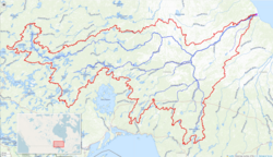
This river drains an area of 135,200 square kilometres (52,201 sq mi) and has a mean discharge of 1,420 cubic metres (50,147 cu ft) per second. For much of its length, the river defines the boundary between
478:
1142:
588:
Etowamami River. The river continues over the Upper
Eskakwa Falls, takes in the right tributary Shabuskwia River, and travels over the Eskakwa Falls and Snake Falls.
463:, the river is known as Kistachowan (or Chichichiwan or Chichewan) Sipi. According to traditional Mushkegowuk knowledge, "every curve in the river has a name".
981:
It is a non-operating park, meaning that there are no facilities or services. Visitors have to be experienced in travelling through isolated wilderness.
902:
1020:
1288:
64:
494:. Trade in the area was long contested by the English from Hudson Bay and the French on the Great Lakes. Much of the Albany basin was visited by
650:, a diversion of 4,273 cubic feet (121.0 m) per second); and the headwaters of the Kenogami River have been diverted via Long Lake and the
626:
There are three diversions in the Albany River watershed, all diverting water from the James Bay drainage basin and all undertaken as part of
1052:
Restoule, Jean-Paul; Gruner, Sheila; Metatawabin, Edmund (2013). "Learning from Place: A Return to
Traditional Mushkegowuk Ways of Knowing".
1091:
1293:
580:
into
Osnaburgh Lake. From there it flows via a Main Channel (northern) and South Channel around Kagami Island northeast, and takes in the
1283:
1298:
1231:
1087:
990:
576:
The river begins at Lake St. Joseph at an elevation of 371 metres (1,217 ft). and flows over the Rat Rapids dam and under
440:
267:
876:
761:
1149:
1232:"Toporama - Topographic Map Sheets 42M, 42M5, 42M6, 42N, 42O, 43A, 43B, 52P4, 52P5, 52P6, 52P7, 52P8, 52P9, 52P10, 52P11"
791:
180:
194:
1120:
654:(diversion of 1,377 cubic feet (39.0 m) per second). The third diverts the waters of Lake St. Joseph via the
1278:
1212:
1082:
1028:
775:
38:
1217:
781:
751:
731:
596:
539:
424:
34:
530:. In 1777 Glouster House was built 391 kilometres (243 mi) above Henley House on Upashewey Lake. In 1779
655:
507:
483:
995:
771:
546:
491:
674:
756:
616:
592:
566:
511:
460:
428:
143:
767:
591:
The river empties into the
Akimiski Strait on James Bay via a series of channels. The community of
577:
467:
436:
92:
1207:
1077:
787:
522:. In 1775-76 Edward Jarvis from Henley House explored the relation between the Kenogami and the
518:. In 1743 Henley House was established 260 kilometres (160 mi) upriver at the mouth of the
1116:
396:
Cheepay River, Streatfeild River, Kenogami River, Ogoki River, Shabuskwia River, Misehkow River
704:
635:
620:
570:
497:
490:
Since the Albany extends far to the west, its mouth is a natural site for a trading post. See
148:
627:
523:
514:
at the mouth of the river. In 1685 the French built Fort des Français at the future site of
420:
466:
The river was named in
English after James, Duke of York and Albany, who later became King
1236:
651:
612:
581:
562:
535:
138:
510:(HBC) became the first European to see the Albany. Sometime before 1679 the HBC founded
710:
647:
585:
519:
444:
366:
357:
48:
1241:
1272:
961:
880:
692:
686:
643:
631:
531:
527:
503:
407:
784:/ Fort Hope, just off the main river on Eabamet Lake, connected by the Eabamet River
698:
659:
639:
515:
443:
for the title of longest river entirely in
Ontario. Major tributaries include the
1263:
1176:
716:
678:
448:
240:
663:
917:
904:
542:. By 1790 or so the Fort Albany trade extended all the way to Lake Winnipeg.
282:
269:
209:
196:
804:
432:
363:
28:
803:
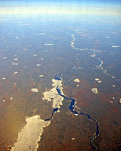
Several islands are found other channels of the river as it flows out to
1148:. North Dakota State Water Commission. pp. 4–5, 10. Archived from
975:
971:
117:
107:
602:
The river is navigable for the first 400 kilometres (249 mi).
764:, an unincorporated place at the confluence with the Cheepay River
673:
477:
1021:"Other Rivers Flowing Into Hudson Bay, James Bay or Ungava Bay"
435:. It is 982 kilometres (610 mi) long to the head of the
666:(diversion of 3,072 cubic feet (87.0 m) per second).
91:
named after James, Duke of York and Albany, later King
549:
until 1912, when it was transferred to
Ontario in the
1143:"Interbasin Water Transfer Projects In North America"
439:(a tributary of Lake St. Joseph), tying it with the
79:
Location of the mouth of the Albany River in
Ontario
957:
949:
941:
933:
896:
888:
869:
545:The land north of the Albany River was part of the
502:long before the English penetrated inland. In 1674
390:
380:
372:
355:
350:
336:
328:
316:
308:
298:
259:
249:
239:
225:
186:
174:
166:
157:
131:
123:
113:
103:
98:
87:
21:
833:A number of islands upstream from Fort Albany:
747:Communities along the river in upstream order:
1027:. Atlas of Canada. 2009-08-17. Archived from
534:surveyed as far as Gloucester House. In 1786
8:
1264:Albany River Provincial Park - Ontario Parks
495:
386:Pagashi River, Henley River, Etowamami River
1015:
1013:
1011:
978:, and a variety of water-shaped landforms.
1240:. Natural Resources Canada. Archived from
1111:
1109:
866:
414:
1071:
1069:
1067:
561:The Albany River is the boundary between
342:1,420 m/s (50,000 cu ft/s)
638:: the Ogoki River has been diverted via
486:encampment beside the Albany River, 1886
320:135,200 km (52,200 sq mi)
1007:
1094:from the original on November 12, 2023
551:Ontario Boundaries Extension Act, 1912
18:
1141:Noone, Michael Stephen (2006-03-13).
423:, Canada, which flows northeast from
7:
1171:
1169:
1047:
1045:
937:95,100 ha (367 sq mi)
887:
71:
595:lies on a southern channel and the
461:Muskhegowuk (Swampy Cree) language
14:
1088:The Historica Dominion Institute
991:List of longest rivers of Canada
630:projects. Two divert water into
70:
63:
47:
27:
948:
1289:Rivers of Thunder Bay District
411:
261: • coordinates
188: • coordinates
41:in the far distance downstream
1:
1054:Canadian Journal of Education
538:was built near the outlet of
528:Michipicoten on Lake Superior
158:Physical characteristics
33:The Albany river between the
1213:Geographical Names Data Base
870:Albany River Provincial Park
863:Albany River Provincial Park
792:Mishkeegogamang First Nation
300: • elevation
227: • elevation
1294:Rivers of Cochrane District
415:
251: • location
181:Unorganized Kenora District
176: • location
1315:
681:crossing the Albany River.
338: • average
231:371 m (1,217 ft)
1284:Rivers of Kenora District
1083:The Canadian Encyclopedia
874:
776:Marten Falls First Nation
346:
324:
312:982 km (610 mi)
235:
162:
58:
46:
39:Marten Falls First Nation
26:
1299:Tributaries of James Bay
1218:Natural Resources Canada
782:Eabametoong First Nation
752:Kashechewan First Nation
597:Kashechewan First Nation
573:Districts to the south.
392: • right
35:Eabametoong First Nation
16:River in Ontario, Canada
1121:Encyclopædia Britannica
820:Farfad Island (Nunavut)
382: • left
996:List of Ontario rivers
682:
496:
487:
37:(out of picture), and
918:51.36250°N 87.77500°W
677:
565:to the north and the
547:Northwest Territories
492:Canadian canoe routes
481:
283:52.28333°N 81.51639°W
210:51.19444°N 90.22222°W
1181:www.ontarioparks.com
846:Fishing Creek Island
722:Shabuskwia River (R)
508:Hudson's Bay Company
429:Northwestern Ontario
304:0 m (0 ft)
958:Governing body
923:51.36250; -87.77500
914: /
725:Etowamami River (L)
648:Long Lake Diversion
599:on a northern one.
584:Misehkow River and
578:Ontario Highway 599
468:James II of England
351:Basin features
288:52.28333; -81.51639
279: /
215:51.19444; -90.22222
206: /
93:James II of England
858:Sand Cherry Island
728:Misehkow River (R)
683:
488:
53:Albany River basin
967:
966:
705:Streatfeild River
636:Great Lakes Basin
526:and went down to
524:Missinaibi Rivers
498:coureurs des bois
431:and empties into
400:
399:
1306:
1279:IUCN Category II
1252:
1250:
1249:
1227:
1225:
1224:
1193:
1192:
1190:
1188:
1173:
1164:
1163:
1161:
1160:
1154:
1147:
1138:
1132:
1131:
1129:
1127:
1113:
1104:
1103:
1101:
1099:
1073:
1062:
1061:
1049:
1040:
1039:
1037:
1036:
1017:
929:
928:
926:
925:
924:
919:
915:
912:
911:
910:
907:
867:
837:Blackbear Island
829:Linklater Island
501:
421:Northern Ontario
419:) is a river in
418:
416:kistachowan sipi
413:
393:
383:
360:
339:
294:
293:
291:
290:
289:
284:
280:
277:
276:
275:
272:
228:
221:
220:
218:
217:
216:
211:
207:
204:
203:
202:
199:
189:
177:
127:Northern Ontario
74:
73:
67:
51:
31:
19:
1314:
1313:
1309:
1308:
1307:
1305:
1304:
1303:
1269:
1268:
1260:
1255:
1247:
1245:
1237:Atlas of Canada
1230:
1222:
1220:
1206:
1202:
1197:
1196:
1186:
1184:
1183:. Ontario Parks
1175:
1174:
1167:
1158:
1156:
1152:
1145:
1140:
1139:
1135:
1125:
1123:
1115:
1114:
1107:
1097:
1095:
1076:Kudelik, Gail.
1075:
1074:
1065:
1051:
1050:
1043:
1034:
1032:
1019:
1018:
1009:
1004:
987:
922:
920:
916:
913:
908:
905:
903:
901:
900:
892:Ontario, Canada
884:
865:
814:Anderson Island
801:
745:
732:Lake St. Joseph
672:
652:Aguasabon River
613:Kenora District
608:
582:right tributary
563:Kenora District
559:
540:Lake St. Joseph
536:Osnaburgh House
476:
457:
425:Lake St. Joseph
391:
381:
356:
337:
301:
287:
285:
281:
278:
273:
270:
268:
266:
265:
262:
255:Akimiski Strait
252:
226:
214:
212:
208:
205:
200:
197:
195:
193:
192:
187:
175:
170:Lake St. Joseph
153:
83:
82:
81:
80:
77:
76:
75:
54:
42:
17:
12:
11:
5:
1312:
1310:
1302:
1301:
1296:
1291:
1286:
1281:
1271:
1270:
1267:
1266:
1259:
1258:External links
1256:
1254:
1253:
1228:
1208:"Albany River"
1203:
1201:
1198:
1195:
1194:
1177:"Albany River"
1165:
1133:
1117:"Albany River"
1105:
1078:"Albany River"
1063:
1041:
1025:Facts - Rivers
1006:
1005:
1003:
1000:
999:
998:
993:
986:
983:
965:
964:
959:
955:
954:
951:
947:
946:
943:
939:
938:
935:
931:
930:
898:
894:
893:
890:
886:
885:
875:
872:
871:
864:
861:
860:
859:
856:
853:
850:
847:
844:
841:
840:Cheepay Island
838:
831:
830:
827:
824:
821:
818:
815:
812:
800:
797:
796:
795:
785:
779:
765:
759:
754:
744:
741:
740:
739:
738:
737:
729:
726:
723:
720:
714:
711:Kenogami River
708:
702:
696:
690:
671:
668:
607:
604:
586:left tributary
558:
555:
520:Kenogami River
475:
472:
456:
453:
445:Kenogami River
398:
397:
394:
388:
387:
384:
378:
377:
374:
370:
369:
367:drainage basin
361:
353:
352:
348:
347:
344:
343:
340:
334:
333:
330:
326:
325:
322:
321:
318:
314:
313:
310:
306:
305:
302:
299:
296:
295:
263:
260:
257:
256:
253:
250:
247:
246:
243:
237:
236:
233:
232:
229:
223:
222:
190:
184:
183:
178:
172:
171:
168:
164:
163:
160:
159:
155:
154:
152:
151:
146:
141:
135:
133:
129:
128:
125:
121:
120:
115:
111:
110:
105:
101:
100:
96:
95:
89:
85:
84:
78:
69:
68:
62:
61:
60:
59:
56:
55:
52:
44:
43:
32:
24:
23:
15:
13:
10:
9:
6:
4:
3:
2:
1311:
1300:
1297:
1295:
1292:
1290:
1287:
1285:
1282:
1280:
1277:
1276:
1274:
1265:
1262:
1261:
1257:
1244:on 2010-02-10
1243:
1239:
1238:
1233:
1229:
1219:
1215:
1214:
1209:
1205:
1204:
1199:
1182:
1178:
1172:
1170:
1166:
1155:on 2011-10-05
1151:
1144:
1137:
1134:
1122:
1118:
1112:
1110:
1106:
1093:
1089:
1085:
1084:
1079:
1072:
1070:
1068:
1064:
1059:
1055:
1048:
1046:
1042:
1031:on 2013-01-22
1030:
1026:
1022:
1016:
1014:
1012:
1008:
1001:
997:
994:
992:
989:
988:
984:
982:
979:
977:
973:
963:
962:Ontario Parks
960:
956:
952:
944:
940:
936:
932:
927:
899:
895:
891:
882:
881:national park
878:
877:IUCN category
873:
868:
862:
857:
855:Oldman Island
854:
852:Norran Island
851:
848:
845:
842:
839:
836:
835:
834:
828:
826:Kakago Island
825:
823:Faries Island
822:
819:
816:
813:
811:Albany Island
810:
809:
808:
806:
798:
793:
789:
786:
783:
780:
777:
773:
769:
766:
763:
760:
758:
755:
753:
750:
749:
748:
742:
735:
734:
733:
730:
727:
724:
721:
718:
715:
712:
709:
706:
703:
700:
697:
694:
693:Cheepay River
691:
688:
687:Pagashi River
685:
684:
680:
676:
669:
667:
665:
661:
657:
656:English River
653:
649:
645:
644:Nipigon River
641:
637:
633:
632:Lake Superior
629:
628:hydroelectric
624:
622:
618:
614:
605:
603:
600:
598:
594:
589:
587:
583:
579:
574:
572:
568:
564:
556:
554:
552:
548:
543:
541:
537:
533:
532:Philip Turnor
529:
525:
521:
517:
513:
509:
505:
504:Charles Bayly
500:
499:
493:
485:
484:First Nations
480:
473:
471:
469:
464:
462:
454:
452:
450:
446:
442:
438:
434:
430:
426:
422:
417:
409:
405:
395:
389:
385:
379:
375:
371:
368:
365:
362:
359:
354:
349:
345:
341:
335:
331:
327:
323:
319:
315:
311:
307:
303:
297:
292:
264:
258:
254:
248:
244:
242:
238:
234:
230:
224:
219:
191:
185:
182:
179:
173:
169:
165:
161:
156:
150:
147:
145:
142:
140:
137:
136:
134:
130:
126:
122:
119:
116:
112:
109:
106:
102:
97:
94:
90:
86:
66:
57:
50:
45:
40:
36:
30:
25:
20:
1246:. Retrieved
1242:the original
1235:
1221:. Retrieved
1211:
1187:10 September
1185:. Retrieved
1180:
1157:. Retrieved
1150:the original
1136:
1124:. Retrieved
1096:. Retrieved
1081:
1057:
1053:
1033:. Retrieved
1029:the original
1024:
980:
968:
832:
802:
772:Marten Falls
746:
699:Henley River
660:Nelson River
640:Lake Nipigon
625:
609:
601:
590:
575:
560:
550:
544:
516:Henley House
489:
465:
458:
441:Severn River
404:Albany River
403:
401:
358:River system
22:Albany River
1060:(2): 68–86.
950:Established
942:Designation
921: /
897:Coordinates
843:Comb Island
762:Ghost River
757:Fort Albany
743:Communities
717:Ogoki River
679:Winter road
670:Tributaries
623:Districts.
617:Thunder Bay
593:Fort Albany
567:Thunder Bay
512:Fort Albany
449:Ogoki River
373:Tributaries
286: /
213: /
144:Thunder Bay
1273:Categories
1248:2010-06-13
1223:2010-06-13
1159:2011-08-18
1126:17 October
1098:January 7,
1035:2010-06-14
1002:References
909:87°46′30″W
906:51°21′45″N
849:Hat Island
817:Big Island
768:Ogoki Post
664:Hudson Bay
412:ᑭᐢᑕᒍ·ᐊᐣ ᓯᐱ
317:Basin size
274:81°30′59″W
271:52°17′00″N
201:90°13′20″W
198:51°11′40″N
805:James Bay
788:Osnaburgh
736:Cat River
606:Watershed
557:Geography
437:Cat River
433:James Bay
364:James Bay
329:Discharge
245:James Bay
132:Districts
88:Etymology
1092:Archived
985:See also
976:drumlins
972:moraines
945:Waterway
889:Location
642:and the
621:Cochrane
571:Cochrane
149:Cochrane
114:Province
99:Location
1200:Sources
799:Islands
634:in the
506:of the
474:History
459:In the
118:Ontario
104:Country
619:&
376:
332:
309:Length
167:Source
139:Kenora
124:Region
108:Canada
1153:(PDF)
1146:(PDF)
662:into
241:Mouth
1189:2021
1128:2007
1100:2024
953:1989
934:Area
879:II (
658:and
615:and
569:and
455:Name
447:and
408:Cree
402:The
719:(R)
713:(R)
707:(R)
701:(L)
695:(R)
689:(L)
427:in
1275::
1234:.
1216:.
1210:.
1179:.
1168:^
1119:.
1108:^
1090:.
1086:.
1080:.
1066:^
1058:36
1056:.
1044:^
1023:.
1010:^
974:,
807::
770:,
553:.
482:A
470:.
451:.
410::
1251:.
1226:.
1191:.
1162:.
1130:.
1102:.
1038:.
883:)
794:)
790:(
778:)
774:(
646:(
406:(
Text is available under the Creative Commons Attribution-ShareAlike License. Additional terms may apply.