102:
618:
472:
82:
634:
109:
421:, Allandale had a population of 56 people. The locality contained 33 households, in which 60.0% of the population are males and 40.0% of the population are females with a median age of 53, 15 years above the national average. The average weekly household income is $ 850, $ 588 below the national average.
356:
flows through the north of
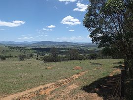
Allandale. Some of the land is used for agricultural purposes. The southeast portion is hilly, undeveloped and mostly cleared of natural vegetation. This catchment area is separate from the Teviot Brook watershed, with run-off flowing in to Allan Creek, a tributary of
549:
372:
134:
242:
230:
541:
369:
Allandale State School opened on 27 February 1928. It closed on 24 March 1963. It was located near the intersection of
Radcliffe/Geiger Road and Hutchinson Road (
785:
484:
302:
665:
101:
740:
526:
1257:
327:
1281:
518:
235:
658:
638:
596:
450:
1145:
975:
1060:
23:
970:
860:
127:
643:
1205:
1080:
1050:
810:
1276:
1225:
1210:
880:
805:
651:
1130:
1105:
1030:
795:
775:
87:
1215:
1055:
1040:
1035:
1025:
1020:
935:
930:
1190:
1100:
1095:
1075:
1045:
945:
915:
890:
735:
710:
50:
1235:
1155:
1140:
1115:
1085:
1070:
910:
875:
870:
865:
845:
820:
730:
715:
600:
454:
425:
418:
339:
195:
179:
45:
1245:
1240:
1200:
1170:
1160:
1090:
1015:
985:
960:
950:
885:
855:
800:
780:
770:
760:
720:
695:
679:
545:
492:
307:
290:
275:
81:
40:
1230:
1220:
1195:
1125:
1120:
1065:
1005:
965:
905:
895:
850:
790:
765:
745:
725:
282:
1185:
1150:
1135:
1110:
1010:
995:
990:
835:
830:
825:
815:
755:
700:
575:
297:
270:
1180:
1165:
1000:
980:
955:
925:
920:
750:
265:
247:
940:
840:
675:
522:
331:
213:
900:
1175:
617:
471:
1270:
35:
353:
358:
335:
222:
72:
388:
374:
150:
136:
571:
633:
705:
218:
647:
485:"Allandale – locality in Scenic Rim Region (entry 45104)"
241:
229:
212:
204:
194:
186:
174:
126:
66:
254:
659:
8:
445:
443:
441:
428:, Allandale had a population of 69 people.
342:, Allandale had a population of 69 people.
666:
652:
644:
616:
513:Queensland Family History Society (2010),
470:
80:
63:
542:"Queensland Two Mile series sheet 2m38"
437:
350:There are no major roads in Allandale.
295:
280:
263:
256:
7:
1258:Local government areas of Queensland
515:Queensland schools past and present
208:48.8 km (18.8 sq mi)
14:
552:from the original on 21 June 2021
519:Queensland Family History Society
108:
632:
107:
100:
597:Australian Bureau of Statistics
451:Australian Bureau of Statistics
400:Allandale State School (former)
61:Suburb in Queensland, Australia
162:Allandale (centre of locality)
1:
674:Towns and localities in the
190:1.414/km (3.662/sq mi)
51:GPX (secondary coordinates)
1298:
1254:
686:
517:(Version 1.01 ed.),
313:
259:Suburbs around Allandale:
257:
253:
95:
79:
46:GPX (primary coordinates)
21:Map all coordinates using
1282:Localities in Queensland
29:Download coordinates as:
605:2016 Census QuickStats
489:Queensland Place Names
459:2021 Census QuickStats
680:South East Queensland
641:at Wikimedia Commons
639:Allandale, Queensland
546:Queensland Government
493:Queensland Government
41:GPX (all coordinates)
389:28.0025°S 152.7297°E
338:, Australia. In the
151:28.0061°S 152.7641°E
576:State of Queensland
384: /
243:Federal division(s)
231:State electorate(s)
146: /
1166:Tamborine Mountain
1146:Southern Lamington
976:Lower Mount Walker
572:"Queensland Globe"
394:-28.0025; 152.7297
156:-28.0061; 152.7641
1277:Scenic Rim Region
1264:
1263:
1061:Mount Walker West
676:Scenic Rim Region
637:Media related to
601:"Allandale (SSC)"
528:978-1-921171-26-0
455:"Allandale (SAL)"
332:Scenic Rim Region
321:
320:
317:
316:
1289:
971:Limestone Ridges
861:Fassifern Valley
668:
661:
654:
645:
636:
621:
620:
615:
613:
611:
599:(27 June 2017).
593:
587:
586:
584:
582:
568:
562:
561:
559:
557:
538:
532:
531:
510:
504:
503:
501:
499:
481:
475:
474:
469:
467:
465:
453:(28 June 2022).
447:
408:
407:
405:
404:
403:
401:
396:
395:
390:
385:
382:
381:
380:
377:
255:
170:
169:
167:
166:
165:
163:
158:
157:
152:
147:
144:
143:
142:
139:
111:
110:
104:
84:
75:
69:
64:
1297:
1296:
1292:
1291:
1290:
1288:
1287:
1286:
1267:
1266:
1265:
1260:
1250:
1206:Veresdale Scrub
1176:Tamrookum Creek
1081:North Tamborine
811:Christmas Creek
682:
672:
630:
625:
624:
609:
607:
595:
594:
590:
580:
578:
570:
569:
565:
555:
553:
540:
539:
535:
529:
512:
511:
507:
497:
495:
483:
482:
478:
463:
461:
449:
448:
439:
434:
415:
399:
397:
393:
391:
387:
386:
383:
378:
375:
373:
371:
370:
367:
348:
187: • Density
161:
159:
155:
153:
149:
148:
145:
140:
137:
135:
133:
132:
122:
121:
120:
119:
118:
117:
116:
112:
91:
71:
70:
67:
62:
59:
58:
57:
56:
55:
12:
11:
5:
1295:
1293:
1285:
1284:
1279:
1269:
1268:
1262:
1261:
1256:Main article:
1255:
1252:
1251:
1249:
1248:
1243:
1238:
1233:
1228:
1226:Wilsons Plains
1223:
1218:
1213:
1211:Wallaces Creek
1208:
1203:
1198:
1193:
1188:
1183:
1178:
1173:
1168:
1163:
1158:
1153:
1148:
1143:
1138:
1133:
1128:
1123:
1118:
1113:
1108:
1103:
1098:
1093:
1088:
1083:
1078:
1073:
1068:
1063:
1058:
1053:
1051:Mount Lindesay
1048:
1043:
1038:
1033:
1028:
1023:
1018:
1013:
1008:
1003:
998:
993:
988:
983:
978:
973:
968:
963:
958:
953:
948:
943:
938:
933:
928:
923:
918:
913:
908:
903:
898:
893:
888:
883:
881:Frenches Creek
878:
873:
868:
863:
858:
853:
848:
843:
838:
833:
828:
823:
818:
813:
808:
806:Chinghee Creek
803:
798:
793:
788:
783:
778:
773:
768:
763:
758:
753:
748:
743:
738:
733:
728:
723:
718:
713:
708:
703:
698:
693:
687:
684:
683:
673:
671:
670:
663:
656:
648:
629:
628:External links
626:
623:
622:
588:
563:
533:
527:
505:
476:
436:
435:
433:
430:
414:
411:
366:
363:
347:
344:
319:
318:
315:
314:
311:
310:
305:
300:
294:
293:
288:
285:
279:
278:
273:
268:
262:
261:
251:
250:
245:
239:
238:
233:
227:
226:
216:
210:
209:
206:
202:
201:
198:
192:
191:
188:
184:
183:
176:
172:
171:
130:
124:
123:
114:
113:
106:
105:
99:
98:
97:
96:
93:
92:
85:
77:
76:
60:
54:
53:
48:
43:
38:
32:
26:
19:
18:
17:
13:
10:
9:
6:
4:
3:
2:
1294:
1283:
1280:
1278:
1275:
1274:
1272:
1259:
1253:
1247:
1244:
1242:
1239:
1237:
1234:
1232:
1229:
1227:
1224:
1222:
1219:
1217:
1214:
1212:
1209:
1207:
1204:
1202:
1199:
1197:
1194:
1192:
1189:
1187:
1184:
1182:
1179:
1177:
1174:
1172:
1169:
1167:
1164:
1162:
1159:
1157:
1154:
1152:
1149:
1147:
1144:
1142:
1139:
1137:
1134:
1132:
1131:Running Creek
1129:
1127:
1124:
1122:
1119:
1117:
1114:
1112:
1109:
1107:
1106:Peak Crossing
1104:
1102:
1099:
1097:
1094:
1092:
1089:
1087:
1084:
1082:
1079:
1077:
1074:
1072:
1069:
1067:
1064:
1062:
1059:
1057:
1054:
1052:
1049:
1047:
1044:
1042:
1039:
1037:
1034:
1032:
1031:Mount Edwards
1029:
1027:
1024:
1022:
1019:
1017:
1014:
1012:
1009:
1007:
1004:
1002:
999:
997:
994:
992:
989:
987:
984:
982:
979:
977:
974:
972:
969:
967:
964:
962:
959:
957:
954:
952:
949:
947:
944:
942:
939:
937:
934:
932:
929:
927:
924:
922:
919:
917:
914:
912:
909:
907:
904:
902:
899:
897:
894:
892:
889:
887:
884:
882:
879:
877:
874:
872:
869:
867:
864:
862:
859:
857:
854:
852:
849:
847:
844:
842:
839:
837:
834:
832:
829:
827:
824:
822:
819:
817:
814:
812:
809:
807:
804:
802:
799:
797:
796:Carneys Creek
794:
792:
789:
787:
784:
782:
779:
777:
776:Burnett Creek
774:
772:
769:
767:
764:
762:
759:
757:
754:
752:
749:
747:
744:
742:
739:
737:
734:
732:
729:
727:
724:
722:
719:
717:
714:
712:
709:
707:
704:
702:
699:
697:
694:
692:
689:
688:
685:
681:
677:
669:
664:
662:
657:
655:
650:
649:
646:
642:
640:
635:
627:
619:
606:
602:
598:
592:
589:
577:
573:
567:
564:
551:
547:
543:
537:
534:
530:
524:
520:
516:
509:
506:
494:
490:
486:
480:
477:
473:
460:
456:
452:
446:
444:
442:
438:
431:
429:
427:
422:
420:
412:
410:
406:
364:
362:
361:to the east.
360:
355:
351:
345:
343:
341:
337:
333:
329:
325:
312:
309:
306:
304:
301:
299:
296:
292:
289:
286:
284:
281:
277:
274:
272:
269:
267:
264:
260:
252:
249:
246:
244:
240:
237:
234:
232:
228:
224:
220:
217:
215:
211:
207:
203:
199:
197:
193:
189:
185:
181:
177:
173:
168:
131:
129:
125:
103:
94:
89:
86:Paddocks and
83:
78:
74:
65:
52:
49:
47:
44:
42:
39:
37:
34:
33:
31:
30:
25:
24:OpenStreetMap
22:
16:
1216:Warrill View
1056:Mount Walker
1041:Mount French
1036:Mount Forbes
1026:Mount Barney
1021:Mount Alford
936:Kents Pocket
931:Kents Lagoon
786:Cannon Creek
690:
631:
608:. Retrieved
604:
591:
579:. Retrieved
566:
554:. Retrieved
536:
514:
508:
496:. Retrieved
488:
479:
462:. Retrieved
458:
423:
416:
413:Demographics
368:
354:Teviot Brook
352:
349:
323:
322:
303:Cannon Creek
258:
88:Mount French
28:
27:
20:
15:
1191:Teviotville
1101:Palen Creek
1076:Nindooinbah
1046:Mount Gipps
946:Knapp Creek
916:Josephville
891:Harrisville
736:Binna Burra
711:Barney View
426:2021 census
419:2016 census
392: /
379:152°43′47″E
359:Logan River
340:2021 census
326:is a rural
196:Postcode(s)
180:2021 census
154: /
141:152°45′51″E
128:Coordinates
1271:Categories
1236:Wonglepong
1156:Tabragalba
1141:Silverdale
1116:Rathdowney
1086:Oaky Creek
1071:Mutdapilly
911:Innisplain
876:Frazerview
871:Flying Fox
866:Ferny Glen
846:Darlington
821:Coleyville
731:Biddaddaba
716:Beaudesert
610:20 October
432:References
398: (
376:28°00′09″S
336:Queensland
236:Scenic Rim
175:Population
160: (
138:28°00′22″S
73:Queensland
1246:Wyaralong
1241:Woolooman
1201:Veresdale
1171:Tamrookum
1161:Tamborine
1091:Obum Obum
1016:Morwincha
986:Merryvale
961:Lamington
951:Kooralbyn
886:Gleneagle
856:Fassifern
801:Charlwood
781:Cainbable
771:Bunjurgen
761:Bromelton
721:Beechmont
696:Allenview
691:Allandale
581:12 August
556:12 August
346:Geography
324:Allandale
308:Kooralbyn
291:Bromeltom
287:Allandale
276:Bromeltom
223:UTC+10:00
214:Time zone
178:69 (
115:Allandale
68:Allandale
1231:Witheren
1221:Washpool
1196:Undullah
1126:Rosevale
1121:Roadvale
1096:O'Reilly
1066:Munbilla
1006:Moogerah
966:Laravale
906:Illinbah
896:Hillview
851:Dugandan
791:Canungra
766:Bunburra
746:Blantyre
726:Benobble
550:Archived
548:. 1955.
328:locality
283:Dugandan
1186:Templin
1151:Tabooba
1136:Sarabah
1111:Radford
1011:Moorang
996:Milford
991:Milbong
836:Croftby
831:Coulson
826:Coochin
816:Clumber
756:Boyland
706:Aratula
701:Anthony
544:(Map).
498:7 March
464:15 June
424:In the
417:In the
365:History
330:in the
298:Milford
271:Coulson
1181:Tarome
1001:Milora
981:Maroon
956:Kulgun
926:Kalbar
921:Kagaru
751:Boonah
741:Birnam
525:
266:Boonah
248:Wright
90:, 2016
941:Kerry
841:Cryna
901:Hoya
612:2018
583:2021
558:2021
523:ISBN
500:2022
466:2024
357:the
219:AEST
205:Area
200:4310
409:).
36:KML
1273::
678:,
603:.
574:.
521:,
491:.
487:.
457:.
440:^
334:,
667:e
660:t
653:v
614:.
585:.
560:.
502:.
468:.
402:)
225:)
221:(
182:)
164:)
Text is available under the Creative Commons Attribution-ShareAlike License. Additional terms may apply.