88:
81:
383:
440:
26:
481:
424:
127:
505:
530:
80:
510:
474:
525:
417:
515:
467:
207:
120:
410:
520:
258:
335:
254:
227:
50:
262:
199:
320:
343:
250:
226:
belt and lies mainly in
Thuringia; with its eastern foothills dropping into the valley of the
171:
382:
362:
451:
394:
316:
266:
195:
159:
439:
500:
494:
447:
231:
211:
315:
The northern part of the heavily forested ridge is designated as the Alter
Stolberg
278:
246:
239:
235:
299:) which rises in the northern part of the ridge. Another prominent hill is the
295:
190:
142:
129:
390:
282:
274:
223:
203:
167:
245:
The Alter
Stolberg lies between the following parishes in clockwise order:
339:
270:
30:
57:
25:
277:
to the north (all in
Thuringia) and the Saxony-Anhalt villages of
184:
342:
refuge castle, which legend has it was the family castle of the
100:
222:
The ridge of the Alter
Stolberg is part of the South Harz
455:
398:
334:. In addition, the ridge is home to the ruins of the
158:
119:
111:
68:
56:
46:
41:
18:
234:river. To the north is the Harz; to the south the
198:in Central Germany. It lies in the districts of
288:The highest hill in the Alter Stolberg is the
475:
418:
8:
319:and large parts of it as the Alter Stolberg
367:at www.harzlife.de. Accessed on 5 Dec 2010.
482:
468:
425:
411:
15:
355:
87:
7:
436:
434:
379:
377:
273:and − on the other sides of that −
14:
506:Nature reserves in Saxony-Anhalt
438:
381:
86:
79:
24:
305:325.2 m above NN
63:357.7 m above NN
330:is the plaster cave, known as
1:
531:Saxony-Anhalt geography stubs
294:357.7 m above
189:357.7 m above
511:Nature reserves in Thuringia
454:. You can help Knowledge by
397:. You can help Knowledge by
307:) in the southeastern part.
547:
433:
376:
526:Thuringia geography stubs
73:
23:
450:location article is a
393:location article is a
364:Die Burgruine Grasburg
516:Nordhausen (district)
218:Geographical location
143:51.52667°N 10.90861°E
321:Protected Landscape
139: /
33:at the foot of the
344:Counts of Stolberg
311:Points of interest
238:through which the
148:51.52667; 10.90861
42:Highest point
521:House of Stolberg
463:
462:
406:
405:
177:
176:
121:Range coordinates
538:
484:
477:
470:
442:
435:
427:
420:
413:
385:
378:
368:
360:
306:
298:
210:in the state of
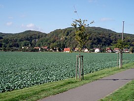
208:Mansfeld-Südharz
202:in the state of
193:
172:Thuringian Basin
162:
154:
153:
151:
150:
149:
144:
140:
137:
136:
135:
132:
90:
89:
83:
64:
28:
16:
546:
545:
541:
540:
539:
537:
536:
535:
491:
490:
489:
488:
432:
431:
374:
372:
371:
361:
357:
352:
313:
304:
293:
220:
188:
187:plateau, up to
160:
147:
145:
141:
138:
133:
130:
128:
126:
125:
107:
106:
105:
104:
103:
98:
97:
96:
95:
91:
62:
37:
12:
11:
5:
544:
542:
534:
533:
528:
523:
518:
513:
508:
503:
493:
492:
487:
486:
479:
472:
464:
461:
460:
443:
430:
429:
422:
415:
407:
404:
403:
386:
370:
369:
354:
353:
351:
348:
317:Nature Reserve
312:
309:
296:sea level (NN)
269:to northwest,
267:Herrmannsacker
253:to the south,
219:
216:
191:sea level (NN)
181:Alter Stolberg
175:
174:
164:
156:
155:
123:
117:
116:
113:
109:
108:
99:
94:Alter Stolberg
93:
92:
85:
84:
78:
77:
76:
75:
74:
71:
70:
66:
65:
60:
54:
53:
48:
44:
43:
39:
38:
35:Alter Stolberg
29:
21:
20:
19:Alter Stolberg
13:
10:
9:
6:
4:
3:
2:
543:
532:
529:
527:
524:
522:
519:
517:
514:
512:
509:
507:
504:
502:
499:
498:
496:
485:
480:
478:
473:
471:
466:
465:
459:
457:
453:
449:
448:Saxony-Anhalt
444:
441:
437:
428:
423:
421:
416:
414:
409:
408:
402:
400:
396:
392:
387:
384:
380:
375:
366:
365:
359:
356:
349:
347:
345:
341:
337:
333:
329:
324:
322:
318:
310:
308:
302:
297:
291:
286:
285:to the east.
284:
280:
276:
272:
268:
264:
261:to the west,
260:
256:
252:
248:
243:
241:
237:
233:
229:
225:
217:
215:
213:
212:Saxony-Anhalt
209:
205:
201:
197:
192:
186:
182:
173:
169:
165:
163:
157:
152:
124:
122:
118:
114:
110:
102:
82:
72:
67:
61:
59:
55:
52:
49:
45:
40:
36:
32:
27:
22:
17:
456:expanding it
445:
399:expanding it
388:
373:
363:
358:
331:
327:
325:
314:
300:
289:
287:
279:Rottleberode
244:
221:
183:is a wooded
180:
178:
161:Parent range
34:
259:Steigerthal
240:River Helme
236:Goldene Aue
230:stream and
166:South Harz
146: /
495:Categories
350:References
290:Königskopf
200:Nordhausen
196:South Harz
134:10°54′31″E
131:51°31′36″N
101:South Harz
51:Königskopf
391:Thuringia
332:Heimkehle
326:Near the
283:Uftrungen
275:Rodishain
228:Krebsbach
224:Zechstein
204:Thuringia
194:, in the
168:Zechstein
69:Geography
58:Elevation
340:medieval
336:Grasburg
328:Reesberg
301:Reesberg
271:Stempeda
263:Buchholz
255:Leimbach
247:Görsbach
31:Stempeda
242:flows.
115:Germany
112:Country
251:Urbach
170:Belt,
446:This
389:This
232:Thyra
185:karst
501:Harz
452:stub
395:stub
338:, a
281:and
265:and
257:and
249:and
206:and
179:The
47:Peak
497::
346:.
323:.
214:.
483:e
476:t
469:v
458:.
426:e
419:t
412:v
401:.
303:(
292:(
Text is available under the Creative Commons Attribution-ShareAlike License. Additional terms may apply.