327:
387:
363:
375:
351:
339:
399:
305:
40:
550:
60:
659:
67:
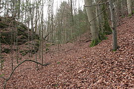
286:, and was probably deepened in the Middle as a spoil heap at both ends of the ditch, where it ends at steep slopes, indicates (Images 4 and 5). In the northern part of ditch is an eight-metre-long and roughly 1.8-metre-wide ditch-like depression. Whether this is natural or manmade is uncertain (Images 4 and 7).
289:
The ovale, relatively level castle site measures 30 by 18 metres and is about five metres above the floor of the ditch (Image 8). Its southern part is slightly higher (Image 9). Apart from the side bounded by the neck ditch, the edge of the site drops for several metres down vertical rock faces
281:
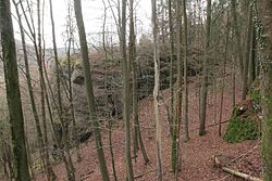
The castle rock is separated from the uphill slopes of the hillside on the southwestern side of the site by a gently arched gully in the terrain, about 6.5 metres deep and up to 20 metres wide (Image 6). It runs for about 45 metres in a northwest to southeast direction. This gully,
290:(title image and Image 2). No traces of the foundations walls of any castle buildings have been discovered to date. From the castle rock there are good views over the Trubach valley and it is on the line of sight to the neighbouring
326:
386:
529:
304:
362:
374:
201:
311:
522:
350:
338:
398:
90:
829:
515:
278:
that juts northwards into the
Trubach valley. (Image 3). It thus lies about 130 metres above the valley floor and is densely wooded today (Image 2).
59:
549:
684:
483:
471:
607:
951:
424:
1076:
722:
824:
622:
1117:
966:
1064:
956:
1107:
643:
576:
441:. (Materialhefte zur bayerischen Vorgeschichte, Series B, Volume 5). Verlag Michael Lassleben, Kallmünz, 1955, p. 98.
1070:
658:
597:
39:
1018:
717:
981:
910:
1043:
1023:
1003:
791:
971:
750:
1053:
946:
633:
628:
1059:
1008:
807:
762:
1033:
648:
592:
586:
1112:
1013:
976:
922:
878:
756:
570:
1038:
1028:
916:
812:
785:
617:
581:
1048:
986:
1081:
997:
883:
868:
728:
602:
539:
928:
904:
818:
712:
474:
at the
Bavarian State Office for the Preservation of Historic Buildings and Monuments (pdf; 142 kB)
291:
225:
29:
779:
888:
845:
739:
702:
638:
332:
Image 3: View of the
Zaunsbacher Berg from the NE above the valley of the Trubach (Dec 2014)
673:
1086:
802:
797:
773:
768:
696:
678:
420:
247:. It has been roughly dated to the mediaeval period. All that has survived of the castle is a
251:
which is probably largely natural. The site is listed as heritage site number D-4-6233-0072:
734:
707:
612:
565:
434:. 2. Auflage. Kommissionsverlag Degener & Co, Neustadt an der Aisch, 1990, pp. 260–261.
873:
690:
229:
205:
745:
1101:
507:
992:
863:
264:
125:
283:
270:
248:
168:
146:
105:
92:
233:
213:
191:
163:
25:
392:
Image 8: View over the slightly higher SE site of the site (Dec 2014)
556:
237:
221:
48:
of the Altes
Schloss. Castle rock seen from the NW (December 2014)
244:
224:. It lies around 1,000 metres south-shouteast of the village of
368:
Image 6: Profile of the ditch. L: the castle site (Dec 2014)
380:
Image 7: Ditch-like depression in the neck ditch (Dec 2014)
511:
439:
Die vor- und frühgeschichtlichen Geländedenkmäler
Oberfrankens
243:
No historical or archaeological information exists about this
937:
897:
854:
838:
666:
573: (Steinhaus, Großhaus, Nuremberg Pflegschloss)
555:
179:
174:
158:
153:
140:
132:
121:
84:
18:
419:. Verlag Palm und Enke, Erlangen and Jena, 1996,
282:which is probably largely natural, was used as a
500:Die Burgen der südwestlichen Fränkischen Schweiz
432:Die Burgen der südwestlichen Fränkischen Schweiz
66:
1000: (Rüsselbach Castle, Burg auf der Katze)
523:
8:
356:Image 5: SE end of the ditch (Dec 2014)
344:Image 4: NW end of the ditch (Dec 2014)
404:Image 9: N side of the site (Dec 2014)
530:
516:
508:
498:, pp. 192 ff. und Hellmut Kunstmann:
15:
484:Location of the burgstall at Bayern Atlas
462:Bayerisches Landesamt für Denkmalpflege
455:
322:
7:
314:Image 2: View from the hill of the
496:Ehemalige Adelssitze im Trubachtal
417:Ehemalige Adelssitze im Trubachtal
212:) is the site of a, now levelled,
14:
657:
548:
397:
385:
373:
361:
349:
337:
325:
303:
65:
58:
38:
274:on a rocky crag on the hill of
216:castle on the hillside of the
1:
962:Altes Schloss (Oberzaunsbach)
598:Neues Schloss (Hiltpoltstein)
236:in the south German state of
1073: (Eberhardstein Castle)
957:Altes Schloss (Affalterthal)
269:450 m above
253:Mittelalterlicher Burgstall
145:450 m above
1134:
989: (Leutenbach Castle?)
967:Altes Schloss (Drügendorf)
667:Castles and castle ruins:
655:
546:
538:Castles in the county of
53:
37:
23:
220:above the valley of the
940:(castle/hillfort sites)
318:terrain (Dec 2014)
263:The simple site of the
210:Burgstall Altes Schloss
106:49.724092°N 11.241601°E
73:Burgstall Altes Schloss
19:Burgstall Altes Schloss
1056: (Stadtmers Bürg)
209:
731: (Altes Schloss)
1118:Forchheim (district)
111:49.724092; 11.241601
32:-"Zaunsbacher Berg"
1067: (Heidenstein)
644:Wolfsberger Schloss
430:Hellmut Kunstmann:
292:Wichsenstein Castle
128:, hillside location
102: /
1108:Castles in Bavaria
1065:Schlossberg Castle
846:Forchheim Fortress
502:, pp. 260 ff.
1095:
1094:
952:Alter Schlossberg
187:
186:
1125:
1071:Thüngfelderstein
1049:Retterner Kanzel
925: (levelled)
919: (levelled)
913: (levelled)
907: (levelled)
821: (levelled)
815: (levelled)
794: (levelled)
788: (levelled)
782: (levelled)
776: (levelled)
765: (levelled)
759: (levelled)
753: (levelled)
751:Niederfellendorf
742: (levelled)
725: (levelled)
699: (levelled)
693: (levelled)
687: (levelled)
681: (levelled)
661:
625: (levelled)
589: (levelled)
552:
532:
525:
518:
509:
503:
492:
486:
481:
475:
469:
463:
460:
401:
389:
377:
365:
353:
341:
329:
307:
276:Zaunsbacher Berg
273:
232:municipality of
230:Upper Franconian
218:Zaunsbacher Berg
204:
154:Site information
149:
117:
116:
114:
113:
112:
107:
103:
100:
99:
98:
95:
69:
68:
62:
42:
33:
16:
1133:
1132:
1128:
1127:
1126:
1124:
1123:
1122:
1098:
1097:
1096:
1091:
1054:Sattelmannsburg
939:
933:
893:
856:
850:
834:
808:Unterleinleiter
763:Oberweilersbach
662:
653:
634:Unterleinleiter
553:
542:
536:
506:
493:
489:
482:
478:
470:
466:
461:
457:
453:
448:
437:Klaus Schwarz:
412:
405:
402:
393:
390:
381:
378:
369:
366:
357:
354:
345:
342:
333:
330:
321:
320:
319:
313:
308:
299:
268:
267:lies at around
261:
200:
199:("Old Castle",
144:
110:
108:
104:
101:
96:
93:
91:
89:
88:
80:
79:
78:
77:
76:
75:
74:
70:
49:
24:
12:
11:
5:
1131:
1129:
1121:
1120:
1115:
1110:
1100:
1099:
1093:
1092:
1090:
1089:
1084:
1079:
1074:
1068:
1062:
1057:
1051:
1046:
1041:
1036:
1031:
1026:
1021:
1016:
1011:
1006:
1001:
995:
990:
984:
979:
974:
969:
964:
959:
954:
949:
943:
941:
935:
934:
932:
931:
926:
920:
914:
908:
901:
899:
895:
894:
892:
891:
886:
881:
879:Niedermirsberg
876:
871:
866:
860:
858:
857:(all levelled)
855:Motte castles:
852:
851:
849:
848:
842:
840:
836:
835:
833:
832:
827:
822:
816:
810:
805:
800:
795:
792:Schlüsselstein
789:
783:
777:
771:
766:
760:
754:
748:
743:
737:
732:
726:
720:
715:
710:
705:
700:
694:
688:
682:
676:
670:
668:
664:
663:
656:
654:
652:
651:
646:
641:
636:
631:
626:
620:
615:
610:
605:
600:
595:
590:
584:
579:
574:
568:
562:
560:
554:
547:
544:
543:
537:
535:
534:
527:
520:
512:
505:
504:
494:Walter Heinz:
487:
476:
464:
454:
452:
449:
447:
446:External links
444:
443:
442:
435:
428:
427:, pp. 191–194.
415:Walter Heinz:
411:
408:
407:
406:
403:
396:
394:
391:
384:
382:
379:
372:
370:
367:
360:
358:
355:
348:
346:
343:
336:
334:
331:
324:
310:
309:
302:
301:
300:
298:
295:
271:sea level (NN)
260:
257:
185:
184:
181:
177:
176:
172:
171:
160:
156:
155:
151:
150:
147:sea level (NN)
142:
138:
137:
134:
130:
129:
123:
119:
118:
86:
82:
81:
72:
71:
64:
63:
57:
56:
55:
54:
51:
50:
43:
35:
34:
21:
20:
13:
10:
9:
6:
4:
3:
2:
1130:
1119:
1116:
1114:
1111:
1109:
1106:
1105:
1103:
1088:
1085:
1083:
1082:Unterailsfeld
1080:
1078:
1077:Tiefenstürmig
1075:
1072:
1069:
1066:
1063:
1061:
1058:
1055:
1052:
1050:
1047:
1045:
1042:
1040:
1037:
1035:
1032:
1030:
1027:
1025:
1022:
1020:
1017:
1015:
1012:
1010:
1009:Heiliger Bühl
1007:
1005:
1002:
999:
996:
994:
991:
988:
985:
983:
980:
978:
975:
973:
970:
968:
965:
963:
960:
958:
955:
953:
950:
948:
945:
944:
942:
936:
930:
927:
924:
921:
918:
915:
912:
909:
906:
903:
902:
900:
898:Manor houses:
896:
890:
887:
885:
882:
880:
877:
875:
872:
870:
869:Ebermannstadt
867:
865:
862:
861:
859:
853:
847:
844:
843:
841:
837:
831:
828:
826:
823:
820:
817:
814:
811:
809:
806:
804:
801:
799:
796:
793:
790:
787:
784:
781:
778:
775:
772:
770:
767:
764:
761:
758:
755:
752:
749:
747:
744:
741:
738:
736:
733:
730:
729:Hiltpoltstein
727:
724:
721:
719:
716:
714:
711:
709:
706:
704:
701:
698:
695:
692:
689:
686:
685:Dietrichstein
683:
680:
677:
675:
672:
671:
669:
665:
660:
650:
647:
645:
642:
640:
637:
635:
632:
630:
627:
624:
621:
619:
616:
614:
611:
609:
606:
604:
601:
599:
596:
594:
591:
588:
585:
583:
580:
578:
575:
572:
569:
567:
564:
563:
561:
558:
551:
545:
541:
533:
528:
526:
521:
519:
514:
513:
510:
501:
497:
491:
488:
485:
480:
477:
473:
472:for Pretzfeld
468:
465:
459:
456:
450:
445:
440:
436:
433:
429:
426:
425:3-7896-0554-9
422:
418:
414:
413:
409:
400:
395:
388:
383:
376:
371:
364:
359:
352:
347:
340:
335:
328:
323:
317:
312:
306:
296:
294:
293:
287:
285:
279:
277:
272:
266:
258:
256:
254:
250:
246:
241:
239:
235:
231:
227:
226:Oberzaunsbach
223:
219:
215:
211:
207:
203:
198:
197:Altes Schloss
194:
193:
182:
178:
173:
170:
166:
165:
161:
157:
152:
148:
143:
139:
135:
131:
127:
124:
120:
115:
87:
83:
61:
52:
47:
41:
36:
31:
30:Oberzaunsbach
27:
22:
17:
1113:Hill castles
961:
923:Walkersbrunn
819:Wichsenstein
718:Gößweinstein
713:Gaillenreuth
623:Schellenberg
603:Hundshaupten
499:
495:
490:
479:
467:
458:
438:
431:
416:
315:
288:
280:
275:
262:
252:
242:
217:
196:
190:
188:
175:Site history
162:
45:
1014:Hetzelsdorf
977:Breitensten
938:Burgställe:
917:Hammermühle
839:Fortresses:
830:Wolkenstein
757:Obertrubach
740:Moschendorf
703:Egloffstein
649:Wüstenstein
593:Heroldsbach
587:Hallerndorf
265:spur castle
259:Description
126:hill castle
109: /
85:Coordinates
1102:Categories
1087:Wartleiten
1060:Schießberg
1039:Lindelburg
1034:Lindelberg
1029:Leutenbach
1019:Hunnenberg
1004:Heidelberg
884:Rüssenbach
813:Vestenberg
803:Thuisbrunn
798:Streitburg
786:Rothenbühl
774:Reifenberg
769:Regensberg
723:Gräfenberg
679:Bieberbach
639:Wiesenthau
608:Jägersburg
577:Guttenburg
571:Gräfenberg
451:References
410:Literature
284:neck ditch
249:neck ditch
169:neck ditch
97:11°14′30″E
94:49°43′27″N
993:Ehrenbürg
987:Burgstein
947:Altenburg
911:Steinhaus
825:Wolfsberg
735:Kohlstein
708:Forchheim
618:Pretzfeld
582:Hagenbach
557:Schlösser
540:Forchheim
316:burgstall
234:Pretzfeld
214:mediaeval
202:‹See Tfd›
192:burgstall
164:burgstall
159:Condition
46:burgstall
26:Pretzfeld
1044:Reisberg
1024:Lehmberg
998:Hainburg
982:Burggraf
929:Wannbach
874:Kersbach
691:Dietzhof
674:Bärnfels
613:Kunreuth
566:Ermreuth
183:Medieval
972:Borschl
905:Dormitz
746:Neideck
697:Dörnhof
297:Gallery
238:Bavaria
228:in the
222:Trubach
195:of the
423:
245:castle
206:German
141:Height
780:Reuth
629:Thurn
180:Built
136:DE-BY
889:Wöhr
864:Burk
421:ISBN
189:The
133:Code
122:Type
44:The
1104::
255:.
240:.
208::
167:,
559::
531:e
524:t
517:v
28:-
Text is available under the Creative Commons Attribution-ShareAlike License. Additional terms may apply.