101:
356:
70:
1106:
1120:
1098:
1084:
108:
440:
85:
454:
The permanent population was 5,925 in the 2021 census. However, similar to adjacent townships, there are also numerous seasonal residents, predominantly cottagers from Ottawa or
Kingston. The total population including seasonal residents was estimated over 10,000, in 3,843 households in 2012.
979:
247:
237:
783:
431:
in 1973 and to
Havelock in 1987. A newer mainline was branched off west of Glen Tay southwest towards Belleville which still handles the CP Rail traffic from Smith Falls to Toronto.
1042:
1167:
100:
1162:
813:
50:
838:
1172:
129:
451:, DeWitts Corners, Elliot, Fallbrook, Feldspar, Glen Tay, Harper, Maberly, Playfairville, Pratt Corners, Scotch Line, Stanleyville and Wemyss.
384:
173:
1035:
54:
487:. With a land area of 528.67 km (204.12 sq mi), it had a population density of 11.2/km (29.0/sq mi) in 2021.
447:
The township comprises the communities of
Althorpe, Bathurst Station, Bells Corners, Bolingbroke, Bolingbroke Siding, Brooke,
1028:
742:
919:
754:
185:
892:
865:
489:
424:
416:
326:
69:
1069:
448:
420:
161:
84:
984:
944:
939:
924:
897:
870:
843:
788:
692:
679:
666:
653:
640:
627:
509:
504:
499:
464:
307:
376:
966:
962:
958:
1129:
989:
793:
734:
468:
368:
318:
297:
75:
1062:
388:
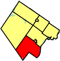
1134:
1020:
399:
The township was incorporated on
January 1, 1998 by amalgamating the former townships of
411:, which date back to the early 19th century. It was originally known as the township of
355:
1073:
428:
1156:
380:
335:
331:
190:
1139:
738:
30:
17:
144:
131:
288:
439:
372:
178:
483:
total private dwellings, a change of 4.6% from its 2016 population of
166:
438:
314:
293:
620:
391:. The township administrative offices are located in Glen Tay.
1024:
346:
1015:
1008:
615:
415:, but adopted the name of Tay Valley on July 30, 2002. The
814:"Tay Valley Township PSB Reports to Council 2012/2013"
491:
Canada census – Tay Valley, Ontario community profile
980:"Tay Valley, Ontario (Code 3509015) Census Profile"
784:"Tay Valley, Ontario (Code 3509015) Census Profile"
341:
325:
304:
287:
279:
271:
266:
258:
253:
243:
233:
225:
217:
209:
204:
196:
184:
172:
160:
41:
1036:
427:then on to Toronto before being abandoned to
8:
603:
1043:
1029:
1021:
721:English and French as first language: 0.6%
602:
493:
423:) passed through Glen Tay heading west to
354:
38:
778:
776:
774:
772:
770:
766:
741:passes through the township, including
583:
569:
556:
542:
539:549.12 km (212.02 sq mi)
536:550.01 km (212.36 sq mi)
533:528.67 km (204.12 sq mi)
528:
514:
495:
340:
324:
286:
265:
262:528.67 km (204.12 sq mi)
252:
203:
195:
159:
124:
93:
81:
66:
61:
1051:Places adjacent to Tay Valley, Ontario
385:United Counties of Leeds and Grenville
928:. Statistics Canada. August 20, 2019.
847:. Statistics Canada. February 4, 2022
303:
278:
270:
257:
248:Lanark—Frontenac—Lennox and Addington
242:
238:Lanark—Frontenac—Lennox and Addington
232:
224:
216:
208:
183:
171:
7:
1168:Lower-tier municipalities in Ontario
1058:
874:. Statistics Canada. August 12, 2021
574:3,750 (total) 2,419 (occupied)
948:. Statistics Canada. July 18, 2021.
901:. Statistics Canada. March 21, 2019
733:The main roads in the township are
1163:Township municipalities in Ontario
819:. Tay Valley Police Services Board
599:References: 2021 2016 2011 earlier
107:
25:
471:, Tay Valley had a population of
1118:
1104:
1096:
1082:
737:and Lanark County Road 10. The
715:English as first language: 93.7%
106:
99:
83:
68:
1173:Municipalities in Lanark County
605:Historical census populations –
89:Tay Valley within Lanark County
718:French as first language: 2.7%
1:
1119:
1083:
743:Murphys Point Provincial Park
724:Other as first language: 2.8%
1105:
1097:
755:List of townships in Ontario
413:Bathurst Burgess Sherbrooke
379:in the southwest corner of
234: • Federal riding
229:Tay Valley Township Council
36:Township in Ontario, Canada
1189:
28:
1056:
988:. Government of Canada -
940:"2001 Community Profiles"
920:"2006 Community Profiles"
893:"2011 Community Profiles"
866:"2016 Community Profiles"
839:"2021 Community Profiles"
792:. Government of Canada -
705:Source: Statistics Canada
704:
635:—
584:
570:
557:
543:
529:
515:
508:
503:
498:
465:2021 Census of Population
244: • Prov. riding
125:
94:
82:
67:
62:
48:
1016:Maberly Agriculture Fair
417:Canadian Pacific Railway
29:Not to be confused with
585:Median household income
564:54.5 (M: 54.3, F: 54.6)
561:57.2 (M: 57.2, F: 57.2)
553:10.1/km (26/sq mi)
550:10.3/km (27/sq mi)
547:11.2/km (29/sq mi)
525:5,571 (-1.1% from 2006)
522:5,665 (+1.7% from 2011)
519:5,925 (+4.6% from 2016)
421:CP Havelock Subdivision
283:11.2/km (29/sq mi)
1070:Drummond/North Elmsley
711:Mother tongue (2021):
444:
419:'s original mainline (
226: • Gov. Body
63:Township of Tay Valley
442:
306: • Summer (
945:2001 Canadian census
925:2006 Canadian census
898:2011 Canadian census
871:2016 Canadian census
844:2021 Canadian census
580:3,698 (total)
577:3,689 (total)
280: • Density
608:
607:Tay Valley, Ontario
141: /
544:Population density
445:
383:, adjacent to the
272: • Total
218: • Reeve
1150:
1149:
1145:
1144:
1130:Central Frontenac
990:Statistics Canada
794:Statistics Canada
709:
708:
597:
596:
571:Private dwellings
469:Statistics Canada
375:, Canada, on the
362:
361:
259: • Land
210: • Type
145:44.867°N 76.383°W
18:Althorpe, Ontario
16:(Redirected from
1180:
1122:
1121:
1108:
1107:
1100:
1099:
1086:
1085:
1063:Lanark Highlands
1059:
1045:
1038:
1031:
1022:
1012:
1011:
1009:Official website
994:
993:
976:
970:
956:
950:
949:
936:
930:
929:
916:
910:
909:
907:
906:
889:
883:
882:
880:
879:
862:
856:
855:
853:
852:
835:
829:
828:
826:
824:
818:
810:
804:
803:
801:
800:
780:
622:
617:
609:
606:
494:
486:
482:
478:
474:
405:South Sherbrooke
389:Frontenac County
358:
353:
350:
348:
311:
156:
155:
153:
152:
151:
146:
142:
139:
138:
137:
134:
110:
109:
103:
87:
74:Road sign along
72:
39:
21:
1188:
1187:
1183:
1182:
1181:
1179:
1178:
1177:
1153:
1152:
1151:
1146:
1135:South Frontenac
1109:
1052:
1049:
1007:
1006:
1003:
998:
997:
978:
977:
973:
957:
953:
938:
937:
933:
918:
917:
913:
904:
902:
891:
890:
886:
877:
875:
864:
863:
859:
850:
848:
837:
836:
832:
822:
820:
816:
812:
811:
807:
798:
796:
782:
781:
768:
763:
751:
731:
604:
601:
600:
492:
484:
480:
476:
472:
461:
437:
397:
345:
305:
200:January 1, 1998
150:44.867; -76.383
149:
147:
143:
140:
135:
132:
130:
128:
127:
121:
120:
119:
118:
117:
116:
115:
111:
90:
78:
58:
44:
37:
34:
23:
22:
15:
12:
11:
5:
1186:
1184:
1176:
1175:
1170:
1165:
1155:
1154:
1148:
1147:
1143:
1142:
1137:
1132:
1126:
1125:
1123:
1116:
1113:
1112:
1110:
1095:
1093:
1090:
1089:
1087:
1080:
1077:
1076:
1067:
1065:
1057:
1054:
1053:
1050:
1048:
1047:
1040:
1033:
1025:
1019:
1018:
1013:
1002:
1001:External links
999:
996:
995:
971:
951:
931:
911:
884:
857:
830:
805:
765:
764:
762:
759:
758:
757:
750:
747:
730:
729:Transportation
727:
726:
725:
722:
719:
716:
707:
706:
702:
701:
698:
695:
689:
688:
685:
682:
676:
675:
672:
669:
663:
662:
659:
656:
650:
649:
646:
643:
637:
636:
633:
630:
624:
623:
618:
613:
598:
595:
594:
592:
589:
586:
582:
581:
578:
575:
572:
568:
567:
565:
562:
559:
555:
554:
551:
548:
545:
541:
540:
537:
534:
531:
527:
526:
523:
520:
517:
513:
512:
507:
502:
497:
490:
460:
457:
436:
433:
396:
393:
360:
359:
343:
339:
338:
329:
323:
322:
312:
302:
301:
291:
285:
284:
281:
277:
276:
273:
269:
268:
264:
263:
260:
256:
255:
251:
250:
245:
241:
240:
235:
231:
230:
227:
223:
222:
219:
215:
214:
211:
207:
206:
202:
201:
198:
194:
193:
188:
182:
181:
176:
170:
169:
164:
158:
157:
123:
122:
113:
112:
105:
104:
98:
97:
96:
95:
92:
91:
88:
80:
79:
73:
65:
64:
60:
59:
49:
46:
45:
42:
35:
24:
14:
13:
10:
9:
6:
4:
3:
2:
1185:
1174:
1171:
1169:
1166:
1164:
1161:
1160:
1158:
1141:
1138:
1136:
1133:
1131:
1128:
1127:
1124:
1117:
1115:
1114:
1111:
1103:
1094:
1092:
1091:
1088:
1081:
1079:
1078:
1075:
1071:
1068:
1066:
1064:
1061:
1060:
1055:
1046:
1041:
1039:
1034:
1032:
1027:
1026:
1023:
1017:
1014:
1010:
1005:
1004:
1000:
991:
987:
986:
981:
975:
972:
968:
964:
960:
955:
952:
947:
946:
941:
935:
932:
927:
926:
921:
915:
912:
900:
899:
894:
888:
885:
873:
872:
867:
861:
858:
846:
845:
840:
834:
831:
815:
809:
806:
795:
791:
790:
785:
779:
777:
775:
773:
771:
767:
760:
756:
753:
752:
748:
746:
744:
740:
736:
728:
723:
720:
717:
714:
713:
712:
703:
699:
696:
694:
691:
690:
686:
683:
681:
678:
677:
673:
670:
668:
665:
664:
660:
657:
655:
652:
651:
647:
644:
642:
639:
638:
634:
631:
629:
626:
625:
619:
614:
611:
610:
593:
590:
587:
579:
576:
573:
566:
563:
560:
552:
549:
546:
538:
535:
532:
524:
521:
518:
511:
506:
501:
496:
488:
470:
467:conducted by
466:
458:
456:
452:
450:
449:Christie Lake
441:
434:
432:
430:
426:
422:
418:
414:
410:
409:North Burgess
406:
402:
394:
392:
390:
386:
382:
381:Lanark County
378:
374:
370:
366:
357:
352:
349:.tayvalleytwp
344:
337:
333:
330:
328:
320:
316:
313:
309:
299:
295:
292:
290:
282:
274:
261:
249:
246:
239:
236:
228:
220:
212:
199:
192:
189:
187:
180:
177:
175:
168:
165:
163:
154:
126:Coordinates:
102:
86:
77:
71:
56:
52:
47:
40:
32:
27:
19:
1140:Rideau Lakes
1101:
983:
974:
954:
943:
934:
923:
914:
903:. Retrieved
896:
887:
876:. Retrieved
869:
860:
849:. Retrieved
842:
833:
821:. Retrieved
808:
797:. Retrieved
787:
739:Rideau Trail
732:
710:
462:
459:Demographics
453:
446:
412:
408:
404:
400:
398:
364:
363:
327:Area code(s)
197:Incorporated
31:Tay, Ontario
26:
985:2016 census
789:2021 census
435:Communities
371:in eastern
148: /
1157:Categories
1102:Tay Valley
905:2012-02-15
878:2019-06-17
851:2024-09-27
799:2024-09-27
761:References
558:Median age
516:Population
475:living in
365:Tay Valley
267:Population
221:Rob Rainer
205:Government
114:Tay Valley
55:lower-tier
43:Tay Valley
735:Highway 7
530:Land area
377:Tay River
289:Time zone
76:Highway 7
823:25 April
749:See also
591:$ 77,686
588:$ 90,000
425:Havelock
401:Bathurst
369:township
213:Township
174:Province
51:Township
479:of its
463:In the
443:Maberly
395:History
373:Ontario
342:Website
179:Ontario
162:Country
136:76°23′W
133:44°52′N
969:census
191:Lanark
186:County
167:Canada
1074:Perth
817:(PDF)
700:+4.6%
697:5,925
687:+1.7%
684:5,665
674:−1.1%
671:5,571
661:+3.6%
658:5,634
648:+5.0%
645:5,440
632:5,180
485:5,665
481:3,750
477:2,419
473:5,925
429:Tweed
367:is a
315:UTC-4
294:UTC-5
275:5,925
967:2006
963:2001
959:1996
825:2018
693:2021
680:2016
667:2011
654:2006
641:2001
628:1996
616:Pop.
612:Year
510:2011
505:2016
500:2021
407:and
387:and
254:Area
351:.ca
347:www
336:343
332:613
319:EDT
308:DST
298:EST
1159::
1072:,
982:.
965:,
961:,
942:.
922:.
895:.
868:.
841:.
786:.
769:^
745:.
621:±%
403:,
334:,
1044:e
1037:t
1030:v
992:.
908:.
881:.
854:.
827:.
802:.
321:)
317:(
310:)
300:)
296:(
57:)
53:(
33:.
20:)
Text is available under the Creative Commons Attribution-ShareAlike License. Additional terms may apply.